|
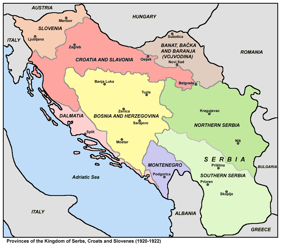
Subdivisions Of The Kingdom Of Yugoslavia
The subdivisions of the Kingdom of Yugoslavia (initially known as the Kingdom of Serbs, Croats, and Slovenes) existed successively in three different forms. From 1918 to 1922, the kingdom maintained the pre-World War I subdivisions of Yugoslavia's predecessor states. In 1922, the state was divided into 33 ''oblasts'' or provinces and, in 1929, a new system of nine banates (in Serbo-Croatian, the word for "banate" is ''banovina'') was implemented. Pre-Yugoslav subdivisions (1918–1922) From 1918 to 1922, Kingdom of Serbs, Croats, and Slovenes continued to be subdivided into the pre-World War I divisions of Austria-Hungary and the formerly independent kingdoms of Serbia and Montenegro. Provinces (''pokrajine'') were: # Slovenia # Croatia and Slavonia # Dalmatia # Bosnia and Herzegovina # Banat, Bačka and Baranja # Serbia ## Northern Serbia ## Southern Serbia # Montenegro These were subdivided into districts and counties: # District of Andrijevica (former Montenegro) # Distri ... [...More Info...] [...Related Items...] OR: [Wikipedia] [Google] [Baidu] |
Country Subdivision
Administrative division, administrative unit,Article 3(1). country subdivision, administrative region, subnational entity, constituent state, as well as many similar terms, are generic names for geographical areas into which a particular, independent sovereign state (country) is divided. Such a unit usually has an administrative authority with the power to take administrative or policy decisions for its area. Usually, the countries have several levels of administrative divisions. The common names for the principal (largest) administrative divisions are: states (i.e. "subnational states", rather than sovereign states), provinces, lands, oblasts, governorates, cantons, prefectures, counties, regions, departments, and emirates. These, in turn, are often subdivided into smaller administrative units known by names such as circuits, counties, ''comarcas'', raions, '' județe'', or districts, which are further subdivided into the municipalities, communes or communities co ... [...More Info...] [...Related Items...] OR: [Wikipedia] [Google] [Baidu] |
Bijelo Polje
Bijelo Polje ( cnr, Бијело Поље, ) is a town in northeastern Montenegro on the Lim River. It has an urban population of 15,400 (2011 census). It is the administrative, economic, cultural and educational centre of northern Montenegro. Bijelo Polje is the center of Bijelo Polje Municipality (population of 46,051). It is the unofficial center of the north-eastern region of Montenegro. Bijelo Polje means 'white field' in Serbo-Croatian. History Bijelo Polje's Saint Peter and Paul Church is the place where the UNESCO Miroslav's Gospel of Miroslav, brother of Serbian ruler Stefan Nemanja was written. During World War II, Bijelo Pole was a prominent location for the anti-fascist resistance movement in Yugoslavia, Montenegro in particular. Population Bijelo Polje is the administrative centre of the Bijelo Polje municipality, which in 2011 had a population of 46,251. The town of Bijelo Polje itself has 15,400 citizens. Population of Bijelo Polje (town): *1981 - 11,927 *1 ... [...More Info...] [...Related Items...] OR: [Wikipedia] [Google] [Baidu] |
Kosovska Mitrovica
Mitrovica ( sq-definite, Mitrovicë; sr-cyrl, Митровица) or Kosovska Mitrovica ( sr-cyrl, Косовска Митровица) is a city and municipality located in Kosovo. Settled on the banks of Ibar and Sitnica rivers, the city is the administrative center of the District of Mitrovica. In 2013, following the North Kosovo crisis, the Serb-majority municipality of North Mitrovica was created, dividing the city in two administrative units. According to the 2011 Census, in Mitrovica live 97,686 inhabitants, 85,360 of which in the southern municipality and 12,326 in North Mitrovica. Name The name of Mitrovica derives from the name ''Demetrius''. It was most probably named after the 8th century Byzantine church ''St. Demetrius'' which was built near Zvečan Fortress, just above the modern Mitrovica, in honor of Saint Demetrius of Thessaloniki. The city was called ''D(i)mitrovica'' until it fell under the Ottoman rule. In 1660, the Ottoman explorer Evliya Çeleb ... [...More Info...] [...Related Items...] OR: [Wikipedia] [Google] [Baidu] |
Kolašin
Kolašin (Montenegrin Cyrillic: Колашин, ) is a town in northern Montenegro. It has a population of 2,989 (2003 census). Kolašin is the centre of Kolašin Municipality (population 9,949) and an unofficial centre of Morača region, named after Morača River. History Ottoman period Kolašin, fortress-settlement, was raised by the Turks in the middle of the 17th century in the namesake village in Nikšić district (nahiye). The village of Kolašin was first mentioned in the Sultan's Decree in 1565, by which the deceased Grand Duke Miloš was replaced by his son Todor. The Turkish town was named after the former village of Kolašin. In 1651, Patriarch Gavrilo assigned Eparch of Zahumsko, the Eparchy of Nikšić, Plana, the Kolašinovićevs and the Morača to Basil of Ostrog. This document also, like the one from 1667, shows that the Orthodox Christian population of this region called the Kolašinovići, was organized in a recognized and respected tribal community of the ... [...More Info...] [...Related Items...] OR: [Wikipedia] [Google] [Baidu] |
Kavadarci
Kavadarci ( mk, Кавадарци ) is a town in the Tikveš region of North Macedonia. In the heart of North Macedonia's wine country, it is home to the largest winery in Southeast Europe, named after the Tikveš plain. The town of Kavadarci is the seat of Kavadarci Municipality. Situated near Kavadarci is North Macedonia's largest artificial lake, Lake Tikveš. History Classical period In the Tikveš region around Kavadarci, many artefacts and structures have been discovered dating back to prehistoric times. Bronze and ceramic artefacts were discovered at an archaeological site in the nearby town of Stobi ( mk, Стоби) dating to the 6th and 7th century BC. This town is said to have been established during the Hellenic civilization, Hellenic period; being on the main road of Via Egnatia that led from the Danube to the Aegean Sea meant it became an important military, economic and cultural hub. The establishment of a mint (coin), mint during the Ancient Rome, Roman period a ... [...More Info...] [...Related Items...] OR: [Wikipedia] [Google] [Baidu] |
Lika-Krbava
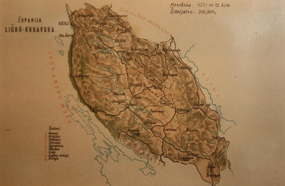
Lika-Krbava County ( hr, Ličko-krbavska županija; sr, Личко-крбавска жупанија; hu, Lika-Korbava vármegye) was a historic administrative subdivision of the Kingdom of Croatia-Slavonia. Croatia-Slavonia was an autonomous kingdom within the Lands of the Crown of Saint Stephen, the Hungarian part of the dual Austro-Hungarian Empire. Its territory is now in southwestern Croatia. Lika and Krbava are the names of two valleys in the county (Gospić lies in Lika). The capital of the county was Gospić (Croatian, in Hungarian: ''Goszpics''). Geography Lika-Krbava county shared borders with the Austrian Kingdom of Dalmatia and Bosnia-Herzegovina and the county of Modruš-Rijeka (also in Croatia-Slavonia). The county has a strip of Adriatic Sea coast. Its area was 6211 km2 around 1910. History The territory of the Lika-Krbava County was part of the Kingdom of Croatia when it entered a personal union with the Kingdom of Hungary in 1102, and with it became ... [...More Info...] [...Related Items...] OR: [Wikipedia] [Google] [Baidu] |
Gospić
Gospić () is a town in the mountainous and sparsely populated region of Lika, Croatia. It is the administrative centre of Lika-Senj County. Gospić is located near the Lika River in the middle of a karst field ( Ličko Polje). Gospić is the third smallest seat of a county government in Croatia. Its status as the county capital helped to spur some development in it, but the town as well as the entire region have suffered a constant decrease in population over the last several decades. Scientist and inventor Nikola Tesla was born in the nearby village of Smiljan and grew up in Gospić. Municipality * Aleksinica, population 169 * Barlete, population 28 * Bilaj, population 162 * , population 25 * Brušane, population 134 * Budak, population 151 * Bužim, population 74 * Debelo Brdo I, population 61 * Debelo Brdo II, population 8 * Divoselo, population 4 * Donje Pazarište, population 125 * Drenovac Radučki, population 0 * Gospić, population 6,575 * Kalinovača, popu ... [...More Info...] [...Related Items...] OR: [Wikipedia] [Google] [Baidu] |
Gornji Milanovac
Gornji Milanovac ( sr-Cyrl, Гoрњи Милановац, ) is a town and municipality located in the Moravica District of central Serbia. The population of the town is 24,216, while the population of the municipality is 44,406. The town was founded in 1853. Before 1859 the original name of the town was Despotovica ( sr-Cyrl, Деспотовица), after the Despotovica river passing by the town. In 1859 the name was changed to Gornji Milanovac at the request of the Prince of Serbia Miloš Obrenović. Its name means ''Upper Milanovac'' (there is a Lower Milanovac as well, while Milanovac stems from the name Milan in Serbian). History Initially, the settlement that was to become Gornji Milanovac (before 1853) was situated in the area of today's village Brusnica. There was some discussion about the suitability of the site for a settlement. The new municipality was to be called Despotovac after the river Despotovica which passes through this municipality (the river name originat ... [...More Info...] [...Related Items...] OR: [Wikipedia] [Google] [Baidu] |
Dubrovnik
Dubrovnik (), historically known as Ragusa (; see notes on naming), is a city on the Adriatic Sea in the region of Dalmatia, in the southeastern semi-exclave of Croatia. It is one of the most prominent tourist destinations in the Mediterranean, a seaport and the centre of the Dubrovnik-Neretva County. Its total population is 42,615 (2011 census). In 1979, the city of Dubrovnik was added to the UNESCO list of World Heritage Sites in recognition of its outstanding medieval architecture and fortified old town. The history of the city probably dates back to the 7th century, when the town known as was founded by refugees from Epidaurum (). It was under the protection of the Byzantine Empire and later under the sovereignty of the Republic of Venice. Between the 14th and 19th centuries, Dubrovnik ruled itself as a free state. The prosperity of the city was historically based on maritime trade; as the capital of the maritime Republic of Ragusa, it achieved a high level of devel ... [...More Info...] [...Related Items...] OR: [Wikipedia] [Google] [Baidu] |
Ćuprija
Ćuprija ( Serbian Cyrillic: Ћуприја, ) is a town and municipality located in the Pomoravlje District of central Serbia. The population of the town is 19,380, while the municipality has 30,645 inhabitants. History The Romans founded the town as a fort Horreum Margi (Horreum: ''Granary'', Margi: '' Morava'') on the road from Constantinople to Rome, where it crosses the river now known as Velika Morava. It served as a Roman military base, had a shield factory and gained the status of ''municipium'' before AD 224. In 505, the Romans were defeated by Goths and Huns under Mundo, a descendant of Attila the Hun. Under Slavic rule, it became known as Ravno (literal translation to English would be "flat"), since it is in a flat river valley. Some local names (of the villages Paljane and Isakovo, of the river Mirosava) recall the major clash in autumn 1191 between the Serbs (under Stefan Nemanja) and the Byzantines (under Emperor Isaac II Angelos). In the 15th century, Ćupr ... [...More Info...] [...Related Items...] OR: [Wikipedia] [Google] [Baidu] |
Cetinje
Cetinje (, ) is a town in Montenegro. It is the former royal capital (''prijestonica'' / приjестоница) of Montenegro and is the location of several national institutions, including the official residence of the president of Montenegro. According to the 2011 census, the town had a population of 14,093 while the Cetinje Municipality had 16,657 residents . Cetinje is the centre of Cetinje Municipality. The city rests on a small karst plain surrounded by limestone mountains, including Mount Lovćen, the legendary mountain in Montenegrin historiography. Cetinje was founded in the 15th century and became a cradle of the culture of Montenegro. Its status as the honorary capital of Montenegro is due to its heritage as a long-serving former capital of Montenegro. Name In Montenegrin, Bosnian, Croatian, and Serbian, it is known as ''Cetinje'' (archaically Цетинѣ / ''Cetině''); in Italian as ''Cettigne''; in Greek as Κετίγνη (''Ketígni''); in Turkish as ''Çetine ... [...More Info...] [...Related Items...] OR: [Wikipedia] [Google] [Baidu] |
Čačak
Čačak ( sr-Cyrl, Чачак, ) is a city and the administrative center of the Moravica District in central Serbia. It is located in the West Morava Valley within the geographical region of Šumadija. , the city proper has 73,331 inhabitants, while the administrative area comprises a total of 115,337 inhabitants. Long known as a spa town, the city lies about 144 km south of the Serbian capital, Belgrade. It is also located near the Ovčar-Kablar Gorge ("Serbian Mount Athos"), with over 30 monasteries built in the gorge since the 14th century. :sr:Ovčarsko-kablarski manastiri Geography Čačak is located in the western part of central Serbia, within the region of Šumadija. Once densely forested, the region is today characterized by its rolling hills and its fruit trees. To the south, past the Ovčar-Kablar Gorge, lie the mountains of the Dinaric Alps. These mountains incline in a gentle and wavy way toward the Čačak valley and the West Morava River. The city administ ... [...More Info...] [...Related Items...] OR: [Wikipedia] [Google] [Baidu] |


.jpg)


