|
Crumbles Murders
The Crumbles Murders are two separate and unrelated crimes which occurred on a shingle beach located between Eastbourne and Pevensey Bay, England—locally referred to as "the Crumbles"—in the 1920s. The first of these two murders is the 1920 bludgeoning murder of 17-year-old Irene Munro, committed by two men: Jack Field and William Gray. The second murder to occur upon the Crumbles is the 1924 murder of 38-year-old Emily Kaye, who was murdered by her lover, Patrick Mahon. The three perpetrators of the two "Crumbles Murders" were all tried at Lewes Assizes before Horace Avory, Mr Justice Avory. All three were executed by hanging at Wandsworth Prison. The executioner of all three men was Thomas Pierrepoint. Murder of Irene Munro Background Irene Violet Munro was a 17-year-old typist, employed by a firm of chartered accountants based in Oxford Street, London. In August 1920, Munro informed her mother, Flora, of her intentions to vacation alone in the seaside resort of Eastbour ... [...More Info...] [...Related Items...] OR: [Wikipedia] [Google] [Baidu] |
Lewes
Lewes () is the county town of East Sussex, England. The town is the administrative centre of the wider Lewes (district), district of the same name. It lies on the River Ouse, Sussex, River Ouse at the point where the river cuts through the South Downs. A traditional market town and centre of communications, in 1264 it was the site of the Battle of Lewes. The town's landmarks include Lewes Castle, Lewes Priory, Bull House (the former home of Thomas Paine), Southover Grange and public gardens, and a 16th-century timber-framed Wealden hall house known as Anne of Cleves House. Other notable features of the area include the Glyndebourne festival, the Lewes Bonfire celebrations and the Lewes Pound. Etymology The place-name "Lewes" is first attested in an Anglo-Saxon charter circa 961 AD, where it appears as ''Læwe''. It appears as ''Lewes'' in the Domesday Book of 1086. The addition of the suffix seems to have been part of a broader trend of Anglo-Normans, Anglo-Norman scribes plu ... [...More Info...] [...Related Items...] OR: [Wikipedia] [Google] [Baidu] |
Wapping
Wapping () is an area in the borough of Tower Hamlets in London, England. It is in East London and part of the East End. Wapping is on the north bank of the River Thames between Tower Bridge to the west, and Shadwell to the east. This position gives the district a strong maritime character. The area was historically composed of two parishes, St George in the East, and the much smaller St John's. Urbanisation of the shoreline began in earnest after the draining of Wapping marsh, and the consolidation of the river wall in the late 16th century. Many of the original buildings were demolished during the construction of the London Docks and Wapping was further seriously damaged during the Blitz. As the Port of London declined after the Second World War, the area became run down, with the great warehouses left empty. Some were demolished, but others such as Tobacco Dock survive. The area underwent further change during the 1980s when warehouses started to be converted into lux ... [...More Info...] [...Related Items...] OR: [Wikipedia] [Google] [Baidu] |
Ironstone
Ironstone is a sedimentary rock, either deposited directly as a ferruginous sediment or created by chemical replacement, that contains a substantial proportion of an iron ore compound from which iron (Fe) can be smelted commercially. Not to be confused with native or telluric iron, which is very rare and found in metallic form, the term ''ironstone'' is customarily restricted to hard, coarsely banded, non-banded, and non-cherty sedimentary rocks of Phanerozoic, post-Precambrian age. The Precambrian deposits, which have a different origin, are generally known as banded iron formations. The iron minerals comprising ironstones can consist either of oxides, i.e. limonite, hematite, and magnetite; carbonates, i.e. siderite; silicates, i.e. chamosite; or some combination of these minerals.U.S. Bureau of Mines Staff (1996) ''Dictionary of Mining, Mineral, & Related Terms.'' Report SP-96-1, U.S. Department of Interior, U.S. Bureau of Mines, Washington, D.C.Neuendorf, K. K. E., J. P. Mehl ... [...More Info...] [...Related Items...] OR: [Wikipedia] [Google] [Baidu] |
Ferrule
A ferrule (a corruption of Latin ' "small bracelet", under the influence of ' "iron") is any of a number of types of objects, generally used for fastening, joining, sealing, or reinforcement. They are often narrow circular rings made from metal, or less commonly, plastic. Ferrules are also often referred to as eyelets or grommets within the manufacturing industry. Most ferrules consist of a circular clamp used to hold together and attach fibers, wires, or posts, generally by crimping, swaging, or otherwise deforming the ferrule to permanently tighten it onto the parts that it holds. Examples *The sleeve, usually plastic or metal, on the end of a shoelace, preventing it from unraveling (called the aglet) *The metal sleeve which is crimped to hold the eraser in place on a pencil *The metal band that binds the bristles or hair of a brush to its handle *The metal ring which holds a chisel blade's tang to its handle *In fiber optic terminations, glass or plastic fi ... [...More Info...] [...Related Items...] OR: [Wikipedia] [Google] [Baidu] |
Pevensey Castle
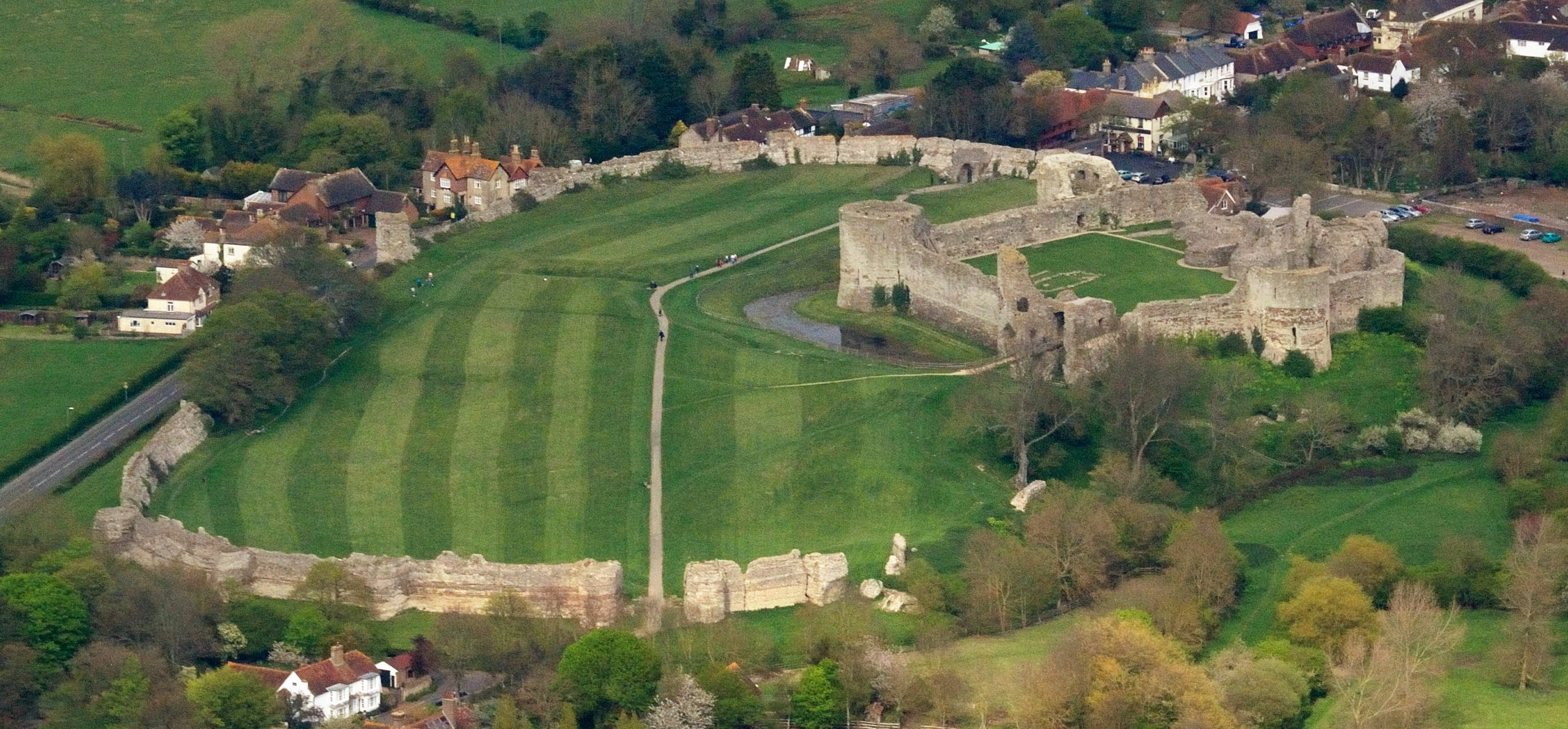
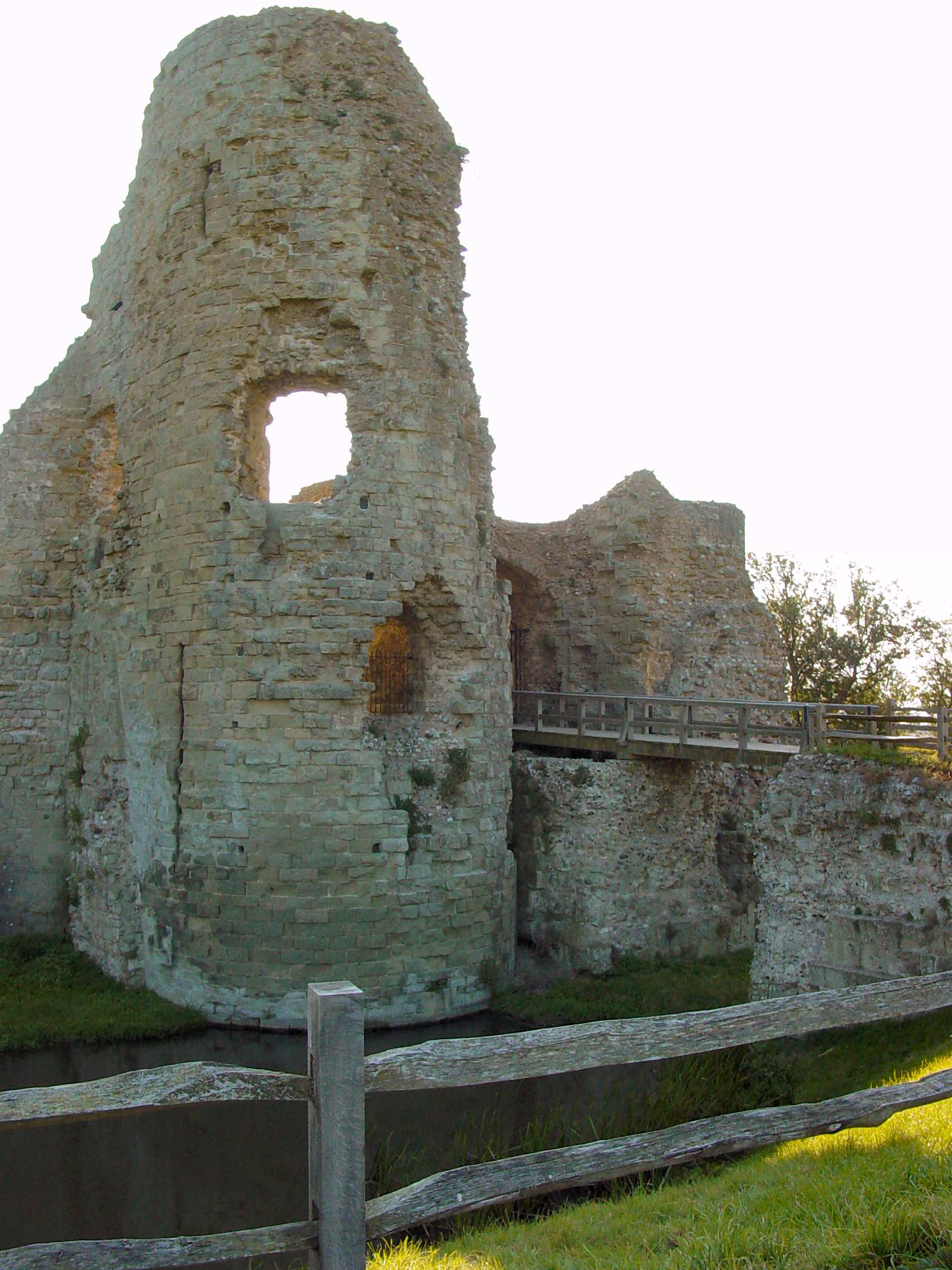
Pevensey Castle is a medieval castle and former Roman Saxon Shore fort at Pevensey in the English county of East Sussex. The site is a scheduled monument in the care of English Heritage and is open to visitors. Built around 290 AD and known to the Romans as ''Anderitum'', the fort appears to have been the base for a fleet called the ''Classis Anderidaensis''. The reasons for its construction are unclear; long thought to have been part of a Roman defensive system to guard the British and Gallic coasts against Saxon pirates, it has more recently been suggested that ''Anderitum'' and the other Saxon Shore forts were built by a usurper in an ultimately unsuccessful attempt to prevent Rome from reimposing its control over Britain. ''Anderitum'' fell into ruin following the end of the Roman occupation but was reoccupied in 1066 by the Normans, for whom it became a key strategic bulwark. A stone keep and fortification was built within the Roman walls and faced several sieges. Althoug ... [...More Info...] [...Related Items...] OR: [Wikipedia] [Google] [Baidu] |
Yard
The yard (symbol: yd) is an English units, English unit of length in both the British imperial units, imperial and US United States customary units, customary systems of measurement equalling 3 foot (unit), feet or 36 inches. Since 1959 it has been by international yard and pound, international agreement standardized as exactly 0.9144 Metre, meter. A distance of 1,760 yards is equal to 1 mile. The theoretical survey foot, US survey yard is very slightly longer. Name The term, ''yard'' derives from the Old English , etc., which was used for branches, staves and measuring rods. It is first attested in the late 7th century Ine of Wessex#Laws, laws of Ine of Wessex, wherein the "yard of land" mentioned is the virgate, yardland, an old English unit of tax assessment equal to hide (unit), hide. Around the same time the Lindisfarne Gospels account of the messengers from John the Baptist in the Gospel of Matthew used it for a branch swayed by the wind. ... [...More Info...] [...Related Items...] OR: [Wikipedia] [Google] [Baidu] |
Witness
In law, a witness is someone who, either voluntarily or under compulsion, provides testimonial evidence, either oral or written, of what they know or claim to know. A witness might be compelled to provide testimony in court, before a grand jury, before an administrative tribunal, before a deposition officer, or in a variety of other legal proceedings. A subpoena is a legal document that commands a person to appear at a proceeding. It is used to compel the testimony of a witness in a trial (law), trial. Usually, it can be issued by a judge or by the lawyer representing the plaintiff or the defendant in a civil trial or by the prosecutor or the defense attorney in a Criminal procedure, criminal proceeding, or by a government agency. In many jurisdictions, it is compulsory to comply with the subpoena and either take an oath or solemnly Affirmation in law, affirm to testify truthfully under penalty of perjury. Although informally a witness includes whoever perceived the event, in l ... [...More Info...] [...Related Items...] OR: [Wikipedia] [Google] [Baidu] |
Hampden Park, Eastbourne
Hampden Park is a suburb of Eastbourne, in the Eastbourne district, in the county of East Sussex, England. It is notable for its unique railway station, where trains on the East Coastway Line often travel through twice, and is thought to be the busiest level crossing in Europe This station, now known as Hampden Park station, was once named 'Willingdon Halt'. Attractions Hampden Park itself is a large pleasant space with a fair sized lake. There is a park cafe called Lakeside Cafe, a children's playground, outdoor tennis courts, playing fields and plenty of routes for joggers and strollers, as well as a large area of sports fields. The area is the home of Eastbourne Rugby Club and two bowls clubs are nearby. Its main inhabitants are the grey squirrel, and several species inhabit the lake, notably mallard ducks, Canada geese, mute swans, moorhen, herons, gulls and the rock pigeon. In 2011 there was a large pond enhancement program carried out on the Decoy Pond. This was funded ... [...More Info...] [...Related Items...] OR: [Wikipedia] [Google] [Baidu] |
Pevensey
Pevensey ( ) is a village and civil parishes in England, civil parish in the Wealden District, Wealden district of East Sussex, England. The main village is located north-east of Eastbourne, one mile (1.6 km) inland from Pevensey Bay. The settlement of Pevensey Bay forms part of the parish. It was here that William the Conqueror made the landing in his Norman Conquest, invasion of England in 1066 after crossing the English Channel from Normandy. Geography Pevensey is situated on a spur of sand and clay, about above sea level. In Roman times this spur was a peninsula that projected into a tidal lagoon and marshes. A small river, Pevensey Haven, runs along the north side of the peninsula and would originally have discharged into the lagoon, but is now largely silted up. The lagoon extended inland as far north as Hailsham and eastwards to Hooe, East Sussex, Hooe. With the effect of longshore drift this large bay was gradually cut off from the sea by shingle, so that today's ... [...More Info...] [...Related Items...] OR: [Wikipedia] [Google] [Baidu] |
Depression (mood)
Depression is a mental state of low Mood (psychology), mood and aversion to activity. It affects about 3.5% of the global population, or about 280 million people worldwide, as of 2020. Depression affects a person's thoughts, behavior, feelings, and subjective well-being, sense of well-being. The pleasure or joy that a person gets from certain experiences is reduced, and the afflicted person often experiences a loss of motivation or interest in those activities. People with depression may experience sadness, feelings of dejection or hopelessness, difficulty in thinking and concentration, or a significant change in appetite or time spent sleeping; Suicidal ideation, suicidal thoughts can also be experienced. Depression can have multiple, sometimes overlapping, origins. Depression can be a symptom of some mood disorders, some of which are also commonly called ''depression'', such as major depressive disorder, bipolar disorder and dysthymia. Additionally, depression can be a norm ... [...More Info...] [...Related Items...] OR: [Wikipedia] [Google] [Baidu] |
Beachy Head
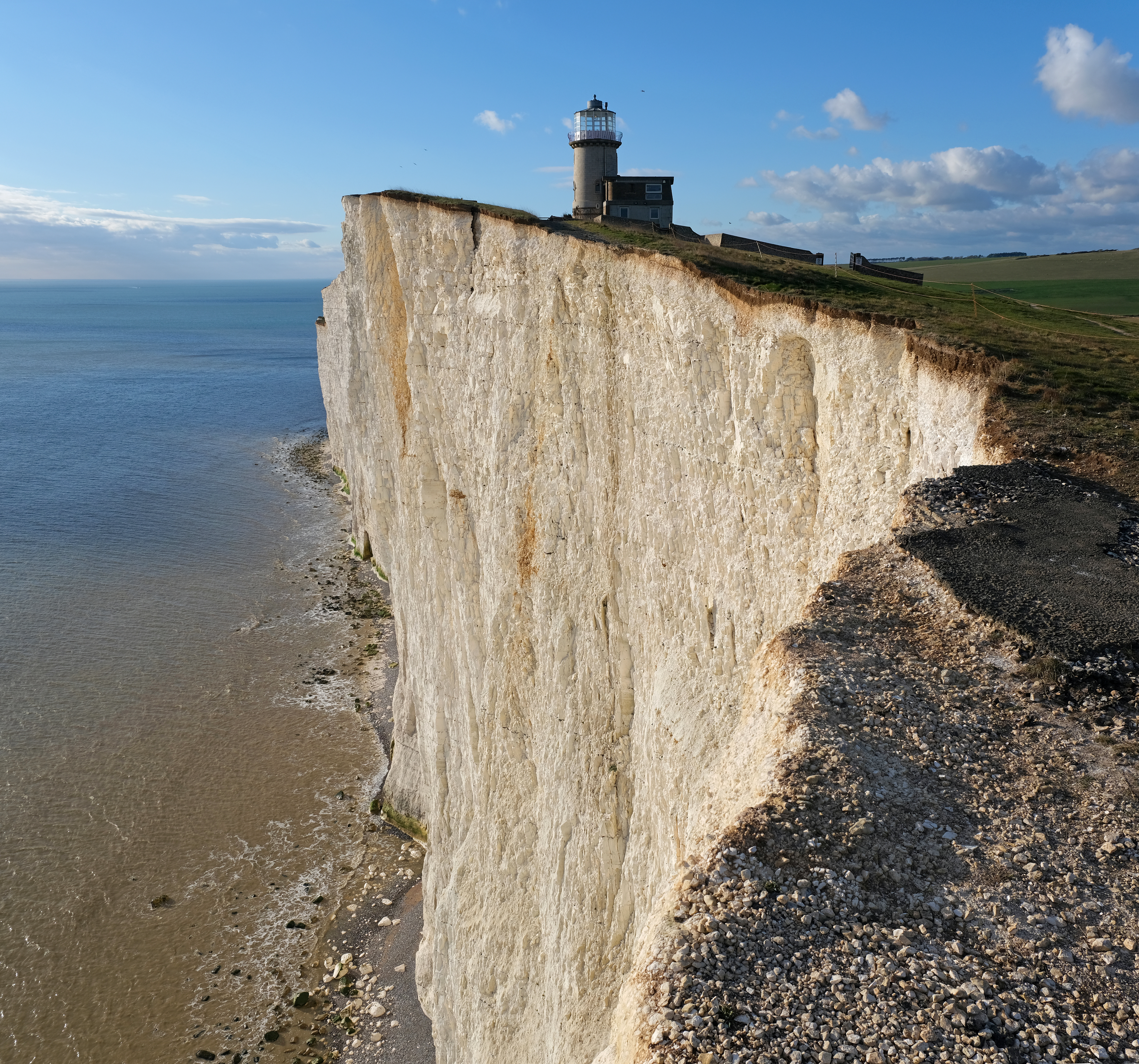
Beachy Head is a Chalk Group, chalk headland in East Sussex, England. It is situated close to Eastbourne, East Sussex, Eastbourne, immediately east of the Seven Sisters, Sussex, Seven Sisters. Beachy Head is located within the administrative area of Eastbourne Borough Council which owns the land, forming part of the Eastbourne Downland Estate. The cliff is the highest chalk sea cliff in Britain, rising to above sea level. The peak allows views of the south east coast towards Dungeness (headland), Dungeness in the east, and to the Isle of Wight in the west. LB&SCR H2 class 4-4-2 (locomotive), 4-4-2 steam locomotive number 424 (later B424, 2424, and 32424) was named ''Beachy Head'' after this landmark. Geology The chalk was formed in the Late Cretaceous epoch, between 66 and 100 million years ago, when the area was under the sea. During the Cenozoic Era, the chalk was tectonic uplift, uplifted (see Geology of England#Cenozoic era, Cenozoic Era). When the Last Glacial Period, las ... [...More Info...] [...Related Items...] OR: [Wikipedia] [Google] [Baidu] |


