Red Hills (Kansas) on:
[Wikipedia]
[Google]
[Amazon]
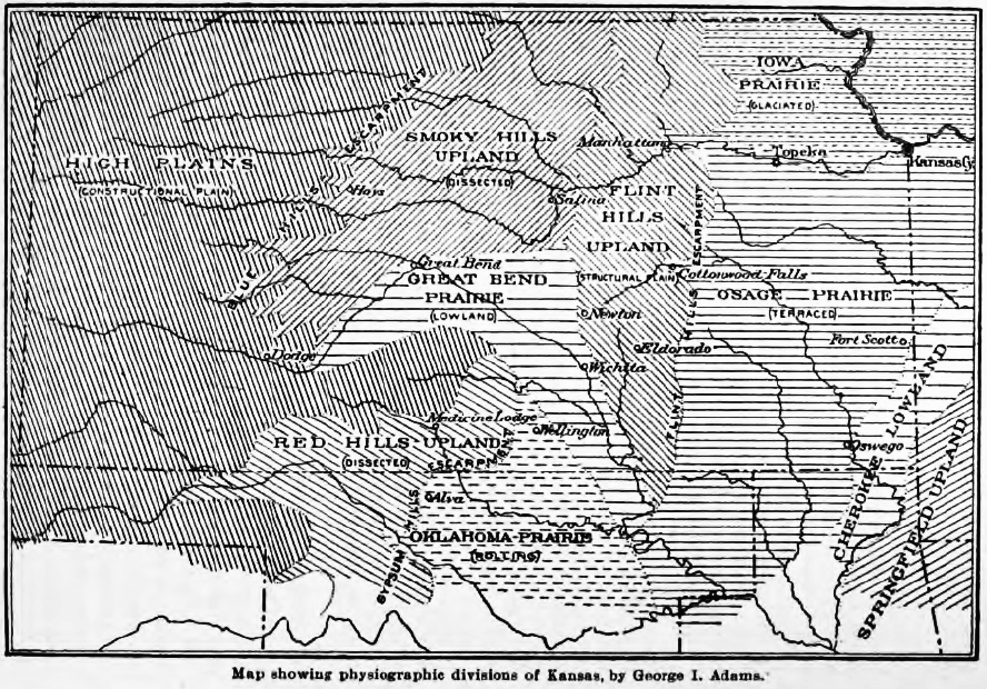
 The Red Hills, also referred to as Gypsum Hills, is the name of a
Red Hills Focus Area-U.S. Fish & Wildlife Service
Regions of Kansas Geology of Kansas {{BarberCountyKS-geo-stub
 The Red Hills, also referred to as Gypsum Hills, is the name of a
 physiographic region
Physiographic regions are a means of defining Earth's landforms into independently distinct, mutually exclusive areas, independent of political boundaries. It is based upon the classic three-tiered approach by Nevin M. Fenneman in 1916, that separ ...
located mostly in Clark, Comanche
The Comanche (), or Nʉmʉnʉʉ (, 'the people'), are a Tribe (Native American), Native American tribe from the Great Plains, Southern Plains of the present-day United States. Comanche people today belong to the List of federally recognized tri ...
and Barber counties in southern and central Kansas
Kansas ( ) is a landlocked U.S. state, state in the Midwestern United States, Midwestern region of the United States. It borders Nebraska to the north; Missouri to the east; Oklahoma to the south; and Colorado to the west. Kansas is named a ...
. This undulating terrain of red-tinted sediments, a product of the underlying geology, does not fit the conventional description of the Great Plains
The Great Plains is a broad expanse of plain, flatland in North America. The region stretches east of the Rocky Mountains, much of it covered in prairie, steppe, and grassland. They are the western part of the Interior Plains, which include th ...
landscape of Kansas.
The red bed sediment
Sediment is a solid material that is transported to a new location where it is deposited. It occurs naturally and, through the processes of weathering and erosion, is broken down and subsequently sediment transport, transported by the action of ...
s of the Red Hills were deposited in an arid continental closed basin that formed within the Pangaea
Pangaea or Pangea ( ) was a supercontinent that existed during the late Paleozoic and early Mesozoic eras. It assembled from the earlier continental units of Gondwana, Euramerica and Siberia during the Carboniferous period approximately 335 mi ...
n supercontinent during the Permian
The Permian ( ) is a geologic period and System (stratigraphy), stratigraphic system which spans 47 million years, from the end of the Carboniferous Period million years ago (Mya), to the beginning of the Triassic Period 251.902 Mya. It is the s ...
Period. Water often flooded this basin forming ephemeral playas of somewhat acidic waters.Benison, K.C. and Goldstein, R.H. 2001. Evaporites and siliciclastics of the Permian Nippewalla Group of Kansas, USA: a case for non-marine deposition in saline lakes and saline pans. Sedimentology 48(1):165-188. The shallow playas were intermittently flooded then dried leaving a mixture of lacustrine sediments and gypsum
Gypsum is a soft sulfate mineral composed of calcium sulfate Hydrate, dihydrate, with the chemical formula . It is widely mined and is used as a fertilizer and as the main constituent in many forms of plaster, drywall and blackboard or sidewalk ...
evaporite
An evaporite () is a water- soluble sedimentary mineral deposit that results from concentration and crystallization by evaporation from an aqueous solution. There are two types of evaporite deposits: marine, which can also be described as oce ...
s. The red color derives from the oxidation
Redox ( , , reduction–oxidation or oxidation–reduction) is a type of chemical reaction in which the oxidation states of the reactants change. Oxidation is the loss of electrons or an increase in the oxidation state, while reduction is ...
of iron
Iron is a chemical element; it has symbol Fe () and atomic number 26. It is a metal that belongs to the first transition series and group 8 of the periodic table. It is, by mass, the most common element on Earth, forming much of Earth's o ...
contained within the deposits.
The region is also known as the Gypsum Hills, because of the large natural deposits of gypsum in this area. The dissolution of underlying gypsum beds has led to the formation of sinkhole
A sinkhole is a depression or hole in the ground caused by some form of collapse of the surface layer. The term is sometimes used to refer to doline, enclosed depressions that are also known as shakeholes, and to openings where surface water ...
s which are common features within the Red Hills region. Big Basin and Little Basin are two well-known sinkholes in western Clark County.
The Red Hills have scenic vistas and some small steep canyons. High points include Mount Nebo (), Mount Jesus () and Mount Lookout (), in Clark County, Kansas.
See also
* Big Basin Prairie Preserve *Tallgrass Prairie National Preserve
Tallgrass Prairie National Preserve is a United States National Preserve located in the Flint Hills region of Kansas, north of Strong City, Kansas, Strong City. The preserve protects a nationally significant example of the once vast tallgrass ...
* Flint Hills
References
External links
Red Hills Focus Area-U.S. Fish & Wildlife Service
Regions of Kansas Geology of Kansas {{BarberCountyKS-geo-stub