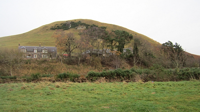
Mowhaugh on:
[Wikipedia]
[Google]
[Amazon]
 Mowhaugh is a hamlet and farm steading near the Calroust Burn and the
retrieved 11 May 2014 In the
retrieved 11 May 2014 It was recorded as early as the 12th century, but by 1607 was said to be ruinous. Today, all that remains is a small graveyard. Mow Parish is now Morebattle parish, and Mowhaugh, the remains of Mow Tower, and the hill of Mow Law, are marked on OS maps. The area is part of the Roxburghe Estate Farms.
Morebattle BorderNet: The former parish of Mow or MolleGeograph image: Looking up the Bowmont Water near MowhaughAmazon link
{{authority control Villages in the Scottish Borders
 Mowhaugh is a hamlet and farm steading near the Calroust Burn and the
 Bowmont Water
Bowmont Water is a stream in the Scottish Borders and Northumberland, England.
It rises in the Cheviot Hills and flows by Mowhaugh, Town Yetholm, and Kirk Yetholm. It then crosses the Anglo-Scottish border and continues past Mindrum Mill, Mi ...
, near Morebattle
Morebattle is a village in the Scottish Borders area of Scotland, on the B6401, seven miles south of Kelso, Scottish Borders, beside the Kale Water, a tributary of the River Teviot. The St. Cuthbert's Way long distance footpath passes through the ...
, in the Scottish Borders
The Scottish Borders ( sco, the Mairches, 'the Marches'; gd, Crìochan na h-Alba) is one of 32 council areas of Scotland. It borders the City of Edinburgh, Dumfries and Galloway, East Lothian, Midlothian, South Lanarkshire, West Lot ...
area of Scotland
Scotland (, ) is a country that is part of the United Kingdom. Covering the northern third of the island of Great Britain, mainland Scotland has a border with England to the southeast and is otherwise surrounded by the Atlantic Ocean to th ...
, and in the former Roxburghshire
Roxburghshire or the County of Roxburgh ( gd, Siorrachd Rosbroig) is a historic county and registration county in the Southern Uplands of Scotland. It borders Dumfriesshire to the west, Selkirkshire and Midlothian to the north-west, and ...
. It is situated about 5 miles (8 km) from the Anglo-Scottish Border
The Anglo-Scottish border () is a border separating Scotland and England which runs for between Marshall Meadows Bay on the east coast and the Solway Firth in the west. The surrounding area is sometimes referred to as "the Borderlands".
Th ...
.
History
The recorded history of 'Mow' or 'Molle' dates back to the 7th century, when it was granted with other lands and settlements on the Bowmont Water toLindisfarne
Lindisfarne, also called Holy Island, is a tidal island off the northeast coast of England, which constitutes the civil parish of Holy Island in Northumberland. Holy Island has a recorded history from the 6th century AD; it was an important ...
.The Former Parish of Mow or Molleretrieved 11 May 2014 In the
Middle Ages
In the history of Europe, the Middle Ages or medieval period lasted approximately from the late 5th to the late 15th centuries, similar to the post-classical period of global history. It began with the fall of the Western Roman Empire ...
it was a substantial settlement with a large population, a peel tower
Peel towers (also spelt pele) are small fortified keeps or tower houses, built along the English and Scottish borders in the Scottish Marches and North of England, mainly between the mid-14th century and about 1600. They were free-stan ...
, and many farmsteads around it. The monks of Kelso Abbey
Kelso Abbey is a ruined Scottish abbey in Kelso, Scotland. It was founded in the 12th century by a community of Tironensian monks first brought to Scotland in the reign of Alexander I. It occupies ground overlooking the confluence of the Tw ...
held fourteen cottages, each of which rented for two shillings yearly and six days' work.
The church of Molle stood on the summit of high ground on the right bank of the Bowmont Water.Church of Molleretrieved 11 May 2014 It was recorded as early as the 12th century, but by 1607 was said to be ruinous. Today, all that remains is a small graveyard. Mow Parish is now Morebattle parish, and Mowhaugh, the remains of Mow Tower, and the hill of Mow Law, are marked on OS maps. The area is part of the Roxburghe Estate Farms.
See also
*List of places in the Scottish Borders
''Map of places in the Scottish Borders compiled from this list'':See the list of places in Scotland for places in other counties.
This list of places in the Scottish Borders includes towns, villages, hamlets, castles, golf courses, historic ho ...
References
*Old Yetholm, Morebattle, Hownam and Mowhaugh, by Roy G. Perkins *Scottish landform examples - 8: Solifluction sheets in the Bowmont Valley, Cheviot Hills. Author: Stephan Harrison, Scottish Geographical Journal, Volume 109, Issue 2, September 1993, pages 119–122.External links
* *Morebattle BorderNet: The former parish of Mow or Molle
{{authority control Villages in the Scottish Borders