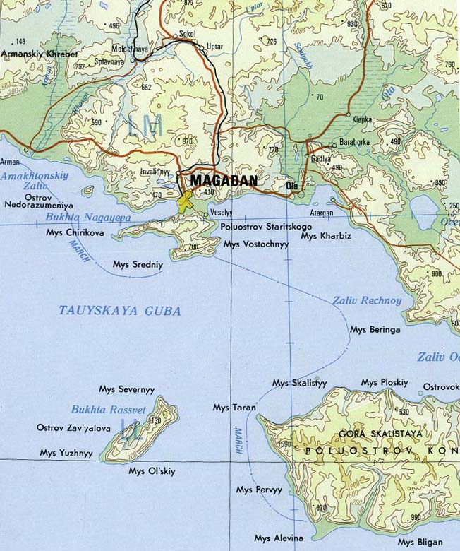
Koni Peninsula on:
[Wikipedia]
[Google]
[Amazon]
 The Koni Peninsula projects into the
 The Koni Peninsula projects into the
 Sea of Okhotsk
The Sea of Okhotsk; Historically also known as , or as ; ) is a marginal sea of the western Pacific Ocean. It is located between Russia's Kamchatka Peninsula on the east, the Kuril Islands on the southeast, Japan's island of Hokkaido on the sou ...
in Magadan Oblast
Magadan Oblast is a federal subjects of Russia, federal subject (an oblast) of Russia. It is geographically located in the Russian Far East, Far East region of the country, and is administratively part of the Far Eastern Federal District. Magadan ...
, in the Russian Far East
The Russian Far East ( rus, Дальний Восток России, p=ˈdalʲnʲɪj vɐˈstok rɐˈsʲiɪ) is a region in North Asia. It is the easternmost part of Russia and the Asia, Asian continent, and is coextensive with the Far Easte ...
, and has an area of 103,434 hectares.
Its north-western shores are on the Taui Bay
Taui Bay ( Russian: Тауйская губа; ''Tauyskaya Guba'') is a body of water in the Sea of Okhotsk off the coast of the Magadan Oblast in Russia. The bay opens to the south.
Geography
It is some 130 km (80 mi) wide and 75 km (4 ...
. Its north-eastern shores are on the Odyan Bay
Odyan Bay (Russian: Залив Одян, trans.: ''Zaliv Odyan'') is a small bay on the north coast of the Sea of Okhotsk. It is in the eastern corner of Taui Bay and washes the Koni Peninsula on the south. The bay is entered between Cape Beringa ...
; the latter one resolves into the ("Pusa
''Pusa'' is a genus of the earless seals, within the family Phocidae. The three species of this genus were split from the genus '' Phoca'', and some sources still give ''Phoca'' as an acceptable synonym for ''Pusa''.
The three species in this ...
Bay"). The Peninsula's south-eastern shore is on the . From the Zabiyaka Bay northwards the makes a notch into the isthmus
An isthmus (; : isthmuses or isthmi) is a narrow piece of land connecting two larger areas across an expanse of water by which they are otherwise separated. A tombolo is an isthmus that consists of a spit or bar, and a strait is the sea count ...
between the peninsula and the mainland, into the valley of the Siglan River.
The Ola
Ola may refer to:
Places Panama
*Olá, a subdistrict in Coclé Province
* Olá District
Russia
*Ola, Russia, an urban settlement in Magadan Oblast
* Ola District, an administrative division in Magadan Oblast
* Ola (river), a river in Magadan ...
sector of the Magadan Nature Reserve
Magadan Nature Reserve () (also Magadansky) is a Russian zapovednik (strict nature reserve) located in four different sectors across the Magadan region of the Russian Far East, including the northern shore of the Sea of Okhotsk. All sites are far ...
is situated on the peninsula, in its western part. Its eastern border runs from (Плоский, "Flat") in the north approximately south-eastwards along several watersheds down to the mouth of the Antara River (about 9 kilometers east of (Блиган).) The shores of the reserve are surrounded by the buffer zone, a 2-kilometer wide strip of the sea from Cape Ploskiy to two nameless streams 9km to the east of the Antara River. Like in the Reserve, any human activities (such as hunting, fishing, ''Laminaria
''Laminaria'' is a genus of brown algae, brown seaweed in the order Kelp, Laminariales (kelp), comprising 31 species native to the north Atlantic and northern Pacific Oceans. This economically important genus is characterized by long, leathery L ...
'' harvesting, etc.) are prohibited. The Ola sector was the first part of the Reserve, established in 1947 after the research carried out following the February 19, 1941 directive of Dalstroy
Dalstroy (, ), also known as Far North Construction Trust, was an organization set up in 1931 in order to manage road construction and the mining of gold in the Russian Far East, including the Magadan Region, Chukotka, parts of Yakutia and parts ...
directorate.
The peninsula adjoins the territory of the regional hunting reserve in the continental part of the Magadan Oblast.
The relief of the Koni Peninsula is mostly mountainous, with peaks rising to 1,300-1,500 meters above sea level. The highest of them is Mount Skalistaya, 1,548 meters. The rivers are small and rapid. In the central part there are small volcanic lakes.
Its westernmost promontory is ("Cape Ram
Ram, ram, or RAM most commonly refers to:
* A male sheep
* Random-access memory, computer memory
* Ram Trucks, US, since 2009
** List of vehicles named Dodge Ram, trucks and vans
** Ram Pickup, produced by Ram Trucks
Ram, ram, or RAM may also ref ...
"). There is a lighthouse (international code M 8015) on its slope.
Notes
References
Magadan Oblast Landforms of the Sea of Okhotsk Peninsulas of Russia Pacific Coast of Russia {{coord, 59.05, 151.52, display=title