Abermenai on:
[Wikipedia]
[Google]
[Amazon]
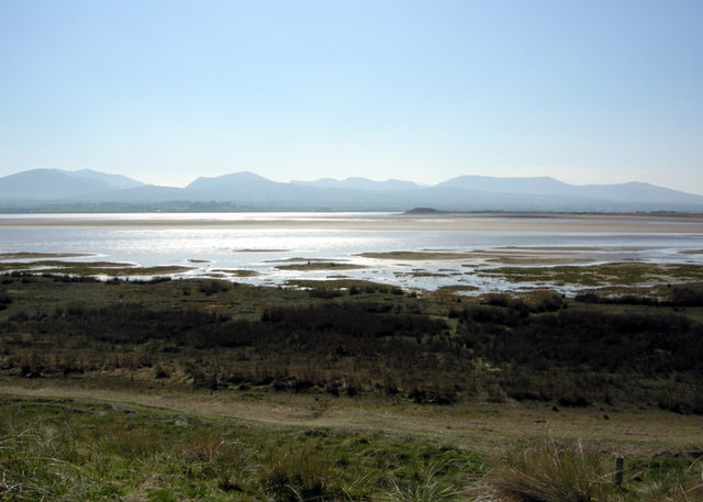
 Abermenai Point ( Welsh: Pwynt Abermenai) is a
 Abermenai Point ( Welsh: Pwynt Abermenai) is a
 headland
A headland, also known as a head, is a coastal landform, a point of land usually high and often with a sheer drop, that extends into a body of water. It is a type of promontory. A headland of considerable size often is called a cape.Whittow, Jo ...
in the southeast of the island of Anglesey
Anglesey ( ; ) is an island off the north-west coast of Wales. It forms the bulk of the Principal areas of Wales, county known as the Isle of Anglesey, which also includes Holy Island, Anglesey, Holy Island () and some islets and Skerry, sker ...
in Wales
Wales ( ) is a Countries of the United Kingdom, country that is part of the United Kingdom. It is bordered by the Irish Sea to the north and west, England to the England–Wales border, east, the Bristol Channel to the south, and the Celtic ...
. It is the southernmost point of the island and is the northern point of the western entrance of the Menai Strait
The Menai Strait () is a strait which separates the island of Anglesey from Gwynedd, on the mainland of Wales. It is situated between Caernarfon Bay in the south-west and Conwy Bay in the north-east, which are both inlets of the Irish Sea. The s ...
.
The headland is mainly composed of sand dunes
A dune is a landform composed of wind- or water-driven sand. It typically takes the form of a mound, ridge, or hill. An area with dunes is called a dune system or a dune complex. A large dune complex is called a dune field, while broad, flat ...
at the end of Newborough Warren and has no road leading up to or onto it. The nearest major public road, along which a public bus runs is the A4080 at Newborough. Due to its exposed location and the nature of the straits the Ordnance Survey
The Ordnance Survey (OS) is the national mapping agency for Great Britain. The agency's name indicates its original military purpose (see Artillery, ordnance and surveying), which was to map Scotland in the wake of the Jacobite rising of ...
map for the point carries a warning ''"Public Rights of Way to Abermenai Point can be dangerous under tidal conditions."''
The earliest recorded ferry crossing route from the island to the mainland ran from the point to the site at which Fort Belan now sits. Records in the late 11th century relating to the then King of Gwynedd
Gwynedd () is a county in the north-west of Wales. It borders Anglesey across the Menai Strait to the north, Conwy, Denbighshire, and Powys to the east, Ceredigion over the Dyfi estuary to the south, and the Irish Sea to the west. The ci ...
, Gruffudd ap Cynan
Gruffudd ap Cynan (–1137) was List of rulers of Gwynedd, King of Gwynedd from 1081 until his death in 1137. In the course of a long and eventful life, he became a key figure in Welsh resistance to House of Normandy, Norman rule.
As a descen ...
state that a ferryman was employed there and ferry houses at both locations have been recorded throughout history. On Gruffudd ap Cynan's death in 1137, the income from the port of Abermenai was inherited by his wife Angharad ferch Owain.
In 1725, Daniel Defoe
Daniel Defoe (; born Daniel Foe; 1660 – 24 April 1731) was an English writer, merchant and spy. He is most famous for his novel ''Robinson Crusoe'', published in 1719, which is claimed to be second only to the Bible in its number of translati ...
, the author of novels such as "''Robinson Crusoe
''Robinson Crusoe'' ( ) is an English adventure novel by Daniel Defoe, first published on 25 April 1719. Written with a combination of Epistolary novel, epistolary, Confessional writing, confessional, and Didacticism, didactic forms, the ...
''" used the crossing on his way to Holyhead
Holyhead (; , "Cybi's fort") is a historic port town, and is the list of Anglesey towns by population, largest town and a Community (Wales), community in the county of Isle of Anglesey, Wales. Holyhead is on Holy Island, Anglesey, Holy Island ...
.Hughes, Margaret: ''Anglesey from the Sea'', page 29. Carreg Gwalch, 2001 The ferry ceased to run in the mid-19th century and by the 1940s almost all trace of it had disappeared. The decline of the ferry service may have been due to the opening of the Menai Suspension Bridge
The Menai Suspension Bridge ( or ) is a suspension bridge spanning the Menai Strait between the island of Anglesey and the mainland of Wales. Designed by Thomas Telford and completed in 1826, it was the world's first major suspension bridge. Th ...
in 1826 and the Britannia Bridge
Britannia Bridge () is a bridge in Wales that crosses the Menai Strait between the Isle of Anglesey and city of Bangor, Gwynedd, Bangor. It was originally designed and built by the noted railway engineer Robert Stephenson as a tubular bridge of ...
in 1850, which provided road and rail links to Anglesey.
References
External links
* Rhosyr Menai Strait Headlands of Anglesey {{Anglesey-geo-stub