|
ZûÀpadnûˋ Slovensko
Western Slovakia () is a subdivision of Slovakia as defined by the Nomenclature of Territorial Units for Statistics (NUTS). It is one of the four classified NUTS-2 statistical regions of Slovakia. The region incorporates the western parts of the country excluding the Bratislava Region, and encompasses an area of . It incorporates three kraje–Nitra, Trnava and TrenáûÙn. It has a population of more than 1.8 million, and is the most populated of the four regions of Slovakia. Classification The country of Slovakia is organized into 12 regions ('' kraje'') for administrative purposes. The Nomenclature of Territorial Units for Statistics (NUTS) organizes the country into four broader level sub-divisions. These are classified as a NUTS-2 statistical regions of Slovakia, and incorporate one or more regions within it. The regions form the NUTS-3 territorial units under them. Geography Western Slovakia incorporates the western parts of the country excluding the Bratislava Reg ... [...More Info...] [...Related Items...] OR: [Wikipedia] [Google] [Baidu] |
Countries Of The World
The following is a list providing an overview of sovereign states around the world with information on their status and recognition of their sovereignty. The 205 listed states can be divided into three categories based on membership within the United Nations System: 193 member states of the United Nations, UN member states, two United Nations General Assembly observers#Current non-member observers, UN General Assembly non-member observer states, and ten other states. The ''sovereignty dispute'' column indicates states having undisputed sovereignty (188 states, of which there are 187 UN member states and one UN General Assembly non-member observer state), states having disputed sovereignty (15 states, of which there are six UN member states, one UN General Assembly non-member observer state, and eight de facto states), and states having a political status of the Cook Islands and Niue, special political status (two states, both in associated state, free association with New ... [...More Info...] [...Related Items...] OR: [Wikipedia] [Google] [Baidu] |
Central Slovakia
Central Slovakia () is a subdivision of Slovakia as defined by the Nomenclature of Territorial Units for Statistics (NUTS). It is one of the four classified NUTS-2 statistical regions of Slovakia. The region incorporates the central parts of the country, and encompasses an area of . It incorporates two kraje–é§ilina, and BanskûÀ Bystrica. The region is home to more than 1.3 million inhabitants. Despite being the largest region of Slovakia by area, it is the second least populated after the Bratislava region. Classification The country of Slovakia is organized into 12 regions ('' kraje'') for administrative purposes. The Nomenclature of Territorial Units for Statistics (NUTS) organizes the country into four broader level sub-divisions. These are classified as a NUTS-2 statistical regions of Slovakia, and incorporate one or more regions within it. The regions form the NUTS-3 territorial units under them. Geography Central Slovakia incorporates the central parts of the c ... [...More Info...] [...Related Items...] OR: [Wikipedia] [Google] [Baidu] |
Life Expectancy
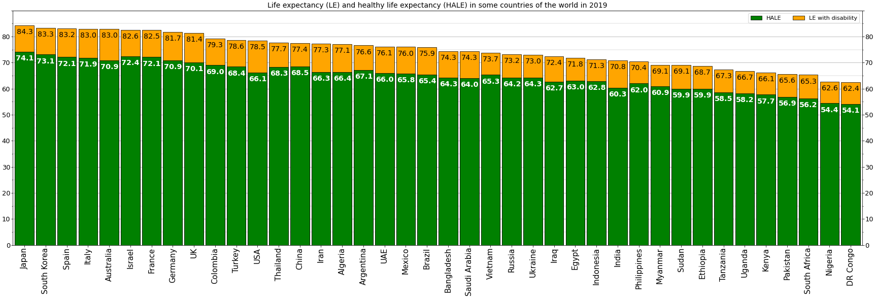
Human life expectancy is a statistical measure of the estimate of the average remaining years of life at a given age. The most commonly used measure is ''life expectancy at birth'' (LEB, or in demographic notation ''e''0, where ''e''x denotes the average life remaining at age ''x''). This can be defined in two ways. ''Cohort'' LEB is the mean length of life of a birth Cohort (statistics), cohort (in this case, all individuals born in a given year) and can be computed only for cohorts born so long ago that all their members have died. ''Period'' LEB is the mean length of life of a hypothetical cohort assumed to be exposed, from birth through death, to the mortality rates observed at a given year. National LEB figures reported by national agencies and international organizations for human populations are estimates of ''period'' LEB. Human remains from the early Bronze Age indicate an LEB of 24. In 2019, world LEB was 73.3. A combination of high infant mortality and d ... [...More Info...] [...Related Items...] OR: [Wikipedia] [Google] [Baidu] |
Unemployment
Unemployment, according to the OECD (Organisation for Economic Co-operation and Development), is the proportion of people above a specified age (usually 15) not being in paid employment or self-employment but currently available for work during the reference period. Unemployment is measured by the unemployment rate, which is the number of people who are unemployed as a percentage of the labour force (the total number of people employed added to those unemployed). Unemployment can have many sources, such as the following: * the status of the economy, which can be influenced by a recession * competition caused by globalization and international trade * new technologies and inventions * policies of the government * regulation and market * war, civil disorder, and natural disasters Unemployment and the status of the economy can be influenced by a country through, for example, fiscal policy. Furthermore, the monetary authority of a country, such as the central bank, can in ... [...More Info...] [...Related Items...] OR: [Wikipedia] [Google] [Baidu] |
Demographics Of Slovakia
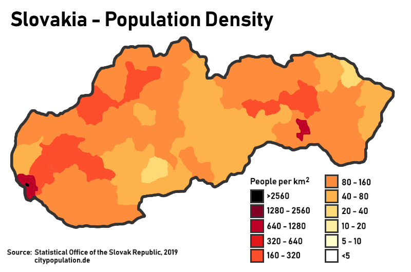
Demography, Demographic features of the population of Slovakia include population density, Ethnic group, ethnicity, education level, health of the populace, economic status, Religion in Slovakia, religious affiliations and other aspects of the population. The demographic statistics are from the Statistical Office of the SR, unless otherwise indicated. Population Total population: 5,422,194 as of 2024. Demographic statistics according to the World Population Review in 2021. *One birth every 10 minutes *One death every 9 minutes *One net migrant every 480 minutes *Net gain of one person every 1440 minutes Population over time Population growth rate :-0.08% (2021 est.) Country comparison to the world: 202nd Fertility The total fertility rate is the number of children born per woman. It is based on fairly good data for the entire period. Sources: Our World In Data and Gapminder Foundation. 1.45 children born/woman (2021 est.) Country comparison to the world: ... [...More Info...] [...Related Items...] OR: [Wikipedia] [Google] [Baidu] |
Statistical Regions Of Slovenia
The statistical regions of Slovenia are 12 administrative entities created in 2000 for legal and statistical purposes. Division By a decree in 2000, Slovenia has been divided into 12 statistical regions (Nomenclature of Territorial Units for Statistics, NUTS-3 level), which are grouped in two cohesion regions (NUTS-2 level). The statistical regions have been grouped into two cohesion regions are: *Eastern Slovenia (''Vzhodna Slovenija'' ã SI01), which groups the Mura, Drava, Carinthia, Savinja, Central Sava, Lower Sava, Southeast Slovenia, and LittoralãInner Carniola regions. *Western Slovenia (''Zahodna Slovenija'' ã SI02), which groups the Central Slovenia, Upper Carniola, Gorizia, and CoastalãKarst regions. Sources Slovenian regions in figures 2014 See also *List of Slovenian regions by Human Development Index *Municipalities of Slovenia *Traditional regions of Slovenia References External links Regions Stat.si (accessed 15 December 2020). Map of st ... [...More Info...] [...Related Items...] OR: [Wikipedia] [Google] [Baidu] |
VûÀh
The VûÀh (; , ; ; w Séowniku geograficznym Krû°lestwa Polskiego i innych krajû°w séowiaéskich (''in Geographical Dictionary of Polish Kingdom and other Slavic countries'').) is the longest within . Towns on the river include Liptovskû§ HrûÀdok, , Ruéƒomberok, [...More Info...] [...Related Items...] OR: [Wikipedia] [Google] [Baidu] |
Little Danube
The Little Danube (, , ) is a branch of the river Danube in Slovakia. It splits from the main river in Bratislava, and flows more or less parallel to the Danube until it flows into the river VûÀh in KolûÀrovo. It is long and its basin size is .PlûÀn manaéƒmentu povodéovûˋho rizikaváiastkovom povodûÙ VûÀhu p. 72 The part of the VûÀh between KolûÀrovo and its confluence with the Danube in is also called ''VûÀh Danube'' (Slovak: ''VûÀéƒsky Dunaj'', Hungarian: ''VûÀg-Duna''). The between the Danube, the Little Danube and the VûÀh Danube rivers ... [...More Info...] [...Related Items...] OR: [Wikipedia] [Google] [Baidu] |
Danube
The Danube ( ; see also #Names and etymology, other names) is the List of rivers of Europe#Longest rivers, second-longest river in Europe, after the Volga in Russia. It flows through Central and Southeastern Europe, from the Black Forest south into the Black Sea. A large and historically important river, it was once a frontier of the Roman Empire. In the 21st century, it connects ten European countries, running through their territories or marking a border. Originating in Germany, the Danube flows southeast for , passing through or bordering Austria, Slovakia, Hungary, Croatia, Serbia, Romania, Bulgaria, Moldova, and Ukraine. Among the many List of cities and towns on the river Danube, cities on the river are four national capitals: Vienna, Bratislava, Budapest, and Belgrade. Its drainage basin amounts to and extends into nine more countries. The Danube's longest headstream, the Breg (river), Breg, rises in Furtwangen im Schwarzwald, while the river carries its name from its ... [...More Info...] [...Related Items...] OR: [Wikipedia] [Google] [Baidu] |
KomûÀrno
KomûÀrno (, , ), colloquially also called ''RûˋvkomûÀrom'', ''ûregkomûÀrom'', ''ûszak-KomûÀrom'' in Hungarian language, Hungarian, is a town in Slovakia at the confluence of the Danube and the VûÀh rivers. Historically it was formed by the "old town" on the left bank of Danube, present day KomûÀrno in Slovakia, and by a "new town" on the right bank, present day KomûÀrom in Hungary, which were historically one administrative unit. Following World War I and the Treaty of Trianon, the border of the newly created Czechoslovakia cut the historical, unified town in half, creating two new independent towns in two countries. KomûÀrno and KomûÀrom are connected by the Elisabeth Bridge, which used to be an official border crossing between Slovakia and Hungary until border checks were lifted due to the Schengen Area rules. In 2020, a new road bridge was opened. KomûÀrno is Slovakia's principal port on the Danube. It is also the center of the Hungarians in Slovakia, Hungarian community in S ... [...More Info...] [...Related Items...] OR: [Wikipedia] [Google] [Baidu] |
River Island
River Island (stylised as RiverIsland and abbreviated as RI) is a London-based, multi-channel fashion brand, founded in 1948 by Bernard Lewis (entrepreneur), Bernard Lewis. The retailer has a presence in over 125 of worldwide markets, in stores and online. Best known for its trend focused womenswear offering, River Island also has menswear, kidswear and pet collections. River Island's collections are entirely designed in-house at the brand's West London head office, and it was one of the first vertical fashion retailers in the UK. In the 1960s, it became an influential name in the womenswear fashion scene, under its previous name: Chelsea Girl. Today, River Island is considered a key player on the UK high street, with 250 stores across the country, including flagship locations in London, Liverpool, Manchester and Birmingham, plus a significant online presence. In recent years, the business has expanded internationally, and continued to grow its online offer. River Island is a ... [...More Info...] [...Related Items...] OR: [Wikipedia] [Google] [Baidu] |
é§itnû§ Ostrov
é§itnû§ ostrov (), also called Veáƒkû§ é§itnû§ ostrov (; , ) to differentiate it from SzigetkûÑz, Malû§ é§itnû§ ostrov (; ; ), is a river island in southwestern Slovakia, extending from Bratislava to KomûÀrno. It lies between the Danube, its tributary Little Danube and VûÀh. The island is a major part of the Danubian Flat. It is the biggest river island in Europe, with an area of , measuring in length and in width. The main towns on the island are KomûÀrno, DunajskûÀ Streda and é amorûÙn. Two boroughs of Bratislava, Vrakuéa and Podunajskûˋ Biskupice, are also located on the island. The Slovnaft refinery is also located on the island. The island is the biggest drinking water reservoir in Slovakia, and one of the biggest in Europe as well. Because of its warm climate, good soils and water reservoirs it is an important agricultural region, with the best conditions for crop production. It is the most fertile region in Slovakia, causing the majority of the island to be deforested. S ... [...More Info...] [...Related Items...] OR: [Wikipedia] [Google] [Baidu] |


