|
Zarishat
Zarishat () is a village in the Amasia Municipality of the Shirak Province of Armenia. Demographics According to 1912 publication of ''Kavkazskiy kalendar'', there was a mainly Karapapakh The Karapapakhs (; ), or Terekeme (; ), are a Turkic people, who originally spoke the Karapapakh language, a western Oghuz language closely related to Azerbaijani and Turkish. Nowadays, the Karapapakh language has been largely supplanted by ... population of 260 in the village of Gonjali of the Kars Okrug in the Kars Oblast. The population of the village since 1897 is as follows: References * * Populated places in Shirak Province {{Shirak-geo-stub ... [...More Info...] [...Related Items...] OR: [Wikipedia] [Google] [Baidu] |
Shirak Province
Shirak (, ) is a provinces of Armenia, province () of Armenia. It is located in the north-west of the country, bordering the provinces of Lori Province, Lori to the east and Aragatsotn Province, Aragatsotn to the south and southeast, and the countries of Turkey to the west and Georgia (country), Georgia to the north. Its capital and largest city is Gyumri, which is the second largest city in Armenia. It is as much semi-desert as it is mountain meadow or high alpine. In the south, the high steppes merge into mountain terrain, being verdant green in the spring, with hues of reddish brown in the summer. The province is served by the Gyumri Shirak International Airport, Shirak International Airport of Gyumri. Etymology Shirak Province is named after the Shirak canton of the historical Ayrarat province of Kingdom of Armenia (antiquity), Ancient Armenia. The early medieval Armenian historian Movses Khorenatsi writes that the name Shirak derives from Shara, who was the great-grandson o ... [...More Info...] [...Related Items...] OR: [Wikipedia] [Google] [Baidu] |
Municipalities Of Armenia
A municipality in Armenia referred to as community ( ''hamaynk'', plural: ''hamaynkner''), is an administrative subdivision consisting of a settlement ( ''bnakavayr'') or a group of settlements ( ''bnakavayrer'') that enjoys local self-government. The settlements are classified as either towns ( ''kaghakner'', singular ''kaghak'') or villages ( ''gyugher'', singular ( ''gyugh''). The administrative centre of a community could either be an urban settlement (town) or a rural settlement (village). Two-thirds of the population are now urbanized. As of 2017, 63.6% of Armenians live in urban areas as compared to 36.4% in rural. As of the end of 2017, Armenia has 503 municipal communities (including Yerevan) of which 46 are urban and 457 are rural. The capital, Yerevan, also has the status of a community. Each municipality bears the same name as its administrative centre, with the exception of 7 municipalities, of which 4 are located in Shirak Province (Ani Municipality with its c ... [...More Info...] [...Related Items...] OR: [Wikipedia] [Google] [Baidu] |
Amasia Municipality
Shirak (, ) is a province () of Armenia. It is located in the north-west of the country, bordering the provinces of Lori to the east and Aragatsotn to the south and southeast, and the countries of Turkey to the west and Georgia to the north. Its capital and largest city is Gyumri, which is the second largest city in Armenia. It is as much semi-desert as it is mountain meadow or high alpine. In the south, the high steppes merge into mountain terrain, being verdant green in the spring, with hues of reddish brown in the summer. The province is served by the Shirak International Airport of Gyumri. Etymology Shirak Province is named after the Shirak canton of the historical Ayrarat province of Ancient Armenia. The early medieval Armenian historian Movses Khorenatsi writes that the name Shirak derives from Shara, who was the great-grandson of Hayk, the legendary patriarch and founder of the Armenian nation. Modern scholars connect Shirak with the name of the Siraces (), a North Cauc ... [...More Info...] [...Related Items...] OR: [Wikipedia] [Google] [Baidu] |
Armenia
Armenia, officially the Republic of Armenia, is a landlocked country in the Armenian Highlands of West Asia. It is a part of the Caucasus region and is bordered by Turkey to the west, Georgia (country), Georgia to the north and Azerbaijan to the east, and Iran and the Azerbaijani exclave of Nakhchivan Autonomous Republic, Nakhchivan to the south. Yerevan is the Capital city, capital, largest city and Economy of Armenia, financial center. The Armenian Highlands has been home to the Hayasa-Azzi, Shupria and Nairi. By at least 600 BC, an archaic form of Proto-Armenian language, Proto-Armenian, an Indo-European languages, Indo-European language, had diffused into the Armenian Highlands.Robert Drews (2017). ''Militarism and the Indo-Europeanizing of Europe''. Routledge. . p. 228: "The vernacular of the Great Kingdom of Biainili was quite certainly Armenian. The Armenian language was obviously the region's vernacular in the fifth century BC, when Persian commanders and Greek writers ... [...More Info...] [...Related Items...] OR: [Wikipedia] [Google] [Baidu] |
Provinces Of Armenia
Armenia is subdivided into eleven administrative divisions. Of these, ten are provinces, known as () or in the singular form () in Armenian. Yerevan is treated separately and granted special administrative status as the country's capital. The chief executive in each of 10 ''marz''es is the ''marzpet'', appointed by the government of Armenia. In Yerevan, the chief executive is the mayor, elected by the Yerevan City Council. First-level administrative divisions The following is a list of the provinces with population, area, and density information. Figures are from the Statistical Committee of Armenia. The area of the Gegharkunik Province includes Lake Sevan which covers of its territory: Municipalities (''hamaynkner'') Within each province of the republic, there are municipal communities (''hamaynkner'', singular ''hamaynk''), currently considered the second-level administrative division in Armenia. Each municipality - known officially as community, either rural or ... [...More Info...] [...Related Items...] OR: [Wikipedia] [Google] [Baidu] |
Kavkazskiy Kalendar
''Kavkazskiy kalendar'' (, ) was an annual almanac published in Tiflis (present-day Tbilisi) in the Russian Empire by the office of the Viceroy of the Caucasus from 1846 to 1917. History ''Kavkazskiy kalendar'' contained a large number of ethnographic and historical materials. Questions of public education, agricultural crops were considered, information about the customs of the Caucasian peoples, their religions, and much more was placed. In addition, there was the so-called "Chronological indication" section, containing a chronological list of significant dates in the history of the Caucasus since ancient times. A significant place in it was also given to statistical (including data on the population of the region), reference and address information about the Caucasus region, including the Dagestan, Kuban and Terek oblasts, as well as the Black Sea and Stavropol Stavropol (, ), known as Voroshilovsk from 1935 until 1943, is a city and the administrative centre of Stavro ... [...More Info...] [...Related Items...] OR: [Wikipedia] [Google] [Baidu] |
Karapapakh
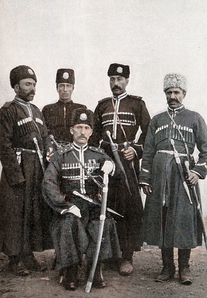
The Karapapakhs (; ), or Terekeme (; ), are a Turkic people, who originally spoke the Karapapakh language, a western Oghuz language closely related to Azerbaijani and Turkish. Nowadays, the Karapapakh language has been largely supplanted by Azerbaijani and Turkish. After moving into Western Asia in the Middle Ages together with other Turkic speakers and Mongol nomads, the Karapapakhs settled along the Debed river in eastern Georgia (along the present-day Georgian-Armenian border). They moved to Qajar Iran, and the Ottoman Empire after the Treaty of Turkmenchay was concluded between Iran and Russia in 1828. The Karapapakhs who remained within the Russian Empire were counted as a separate group in Tsarist population figures. During the Soviet Union's existence, the Karapapakhs were culturally and linguistically assimilated by the Azerbaijanis, and they were counted as "Azerbaijanis" in the 1959 and 1970 Soviet censuses. In 1944 the Karapapakh in the Soviet Union were deport ... [...More Info...] [...Related Items...] OR: [Wikipedia] [Google] [Baidu] |


