|
Yiling Bridge
The Yiling Yangtze River Bridge () is a cable-stayed bridge over the Yangtze River in the city-center of Yichang, Hubei. It has 3 towers and two main spans, with a total of 4 spans including the side spans. It is a road bridge which carries four lanes of roadway and has a toll booth at one end. The bridge has a singular cable tension system, which carries the deck from the center. The Bridge crosses the Yangtze River, near Dagongqiao in Yichang. The main spans are 346 meters each. At the end of the bridge, to the south there is a cloverleaf interchange after the toll booth which is and exchange for the road. The bridge is 6.4 kilometers downriver from the Three Gorges Dam. File:YilingThreeTowerBridgeClipAdj.jpg, From downstream Image:Yiling Bridge in Yichang.jpg, From Yichang Harbor Image:Yiling Yangtze River Bridge1050225.jpg, From northern shore See also * Yangtze River bridges and tunnels The bridges and tunnels across the Yangtze River carry rail and road traffic acros ... [...More Info...] [...Related Items...] OR: [Wikipedia] [Google] [Baidu] |
Yangtze River
The Yangtze or Yangzi ( or ) is the longest river in Eurasia and the third-longest in the world. It rises at Jari Hill in the Tanggula Mountains of the Tibetan Plateau and flows including Dam Qu River the longest source of the Yangtze, in a generally easterly direction to the East China Sea. It is the fifth-largest primary river by discharge volume in the world. Its drainage basin comprises one-fifth of the land area of China, and is home to nearly one-third of the country's population. The Yangtze has played a major role in the history, culture, and economy of China. For thousands of years, the river has been used for water, irrigation, sanitation, transportation, industry, boundary-marking, and war. The Yangtze Delta generates as much as 20% of China's GDP, and the Three Gorges Dam on the Yangtze is the largest hydro-electric power station in the world. In mid-2014, the Chinese government announced it was building a multi-tier transport network, comprising railways, ... [...More Info...] [...Related Items...] OR: [Wikipedia] [Google] [Baidu] |
Wujiagang District
Wujiagang District () is a district of the city of Yichang, Hubei Hubei is a province of China, province in Central China. It has the List of Chinese provincial-level divisions by GDP, seventh-largest economy among Chinese provinces, the second-largest within Central China, and the third-largest among inland ..., People's Republic of China. Administrative divisions Four subdistricts: * Dagongqiao Subdistrict (), Wanshouqiao Subdistrict (), Baotahe Subdistrict (), Wujiagang Subdistrict () The only township is Wujia Township () References County-level divisions of Hubei Geography of Yichang {{Hubei-geo-stub ... [...More Info...] [...Related Items...] OR: [Wikipedia] [Google] [Baidu] |
Hubei
Hubei is a province of China, province in Central China. It has the List of Chinese provincial-level divisions by GDP, seventh-largest economy among Chinese provinces, the second-largest within Central China, and the third-largest among inland provinces. Its provincial capital at Wuhan serves as a major political, cultural, and economic hub for the region. Hubei is associated with the historical state of E that existed during the Western Zhou dynasty (771 BCE). Its name means 'north of the lake', referring to Dongting Lake. It borders Henan to the north, Anhui and Jiangxi to the east, Hunan to the south, and Chongqing and Shaanxi to the west. The high-profile Three Gorges Dam is located at Yichang in the west of the province. History The Hubei region was home to sophisticated Neolithic cultures. By the Spring and Autumn period (770–476 BC), the territory of today's Hubei formed part of the powerful Chu (state), State of Chu. Chu, nominally a tributary state of the Zh ... [...More Info...] [...Related Items...] OR: [Wikipedia] [Google] [Baidu] |
China
China, officially the People's Republic of China (PRC), is a country in East Asia. With population of China, a population exceeding 1.4 billion, it is the list of countries by population (United Nations), second-most populous country after India, representing 17.4% of the world population. China spans the equivalent of five time zones and Borders of China, borders fourteen countries by land across an area of nearly , making it the list of countries and dependencies by area, third-largest country by land area. The country is divided into 33 Province-level divisions of China, province-level divisions: 22 provinces of China, provinces, 5 autonomous regions of China, autonomous regions, 4 direct-administered municipalities of China, municipalities, and 2 semi-autonomous special administrative regions. Beijing is the country's capital, while Shanghai is List of cities in China by population, its most populous city by urban area and largest financial center. Considered one of six ... [...More Info...] [...Related Items...] OR: [Wikipedia] [Google] [Baidu] |
Cable-stayed
A cable-stayed bridge has one or more ''towers'' (or ''pylons''), from which cables support the bridge deck. A distinctive feature are the cables or stays, which run directly from the tower to the deck, normally forming a fan-like pattern or a series of parallel lines. This is in contrast to the modern suspension bridge, where the cables supporting the deck are suspended vertically from the main cable, anchored at both ends of the bridge and running between the towers. The cable-stayed bridge is optimal for spans longer than cantilever bridges and shorter than suspension bridges. This is the range within which cantilever bridges would rapidly grow heavier, and suspension bridge cabling would be more costly. Cable-stayed bridges found wide use in the late 19th century. Early examples, including the Brooklyn Bridge, often combined features from both the cable-stayed and suspension designs. Cable-stayed designs fell from favor in the early 20th century as larger gaps were br ... [...More Info...] [...Related Items...] OR: [Wikipedia] [Google] [Baidu] |
Yichang
Yichang ( zh, s= ), Postal Map Romanization, alternatively romanized as Ichang, is a prefecture-level city located in western Hubei province, China. Yichang had a population of 3.92 million people at the 2022 census, making it the third most populous city in Hubei. The city is famous for the Three Gorges, the Three Gorges Dam and the Gezhouba Dam, all three of which are located in Yiling, Yichang, Yiling District, one of the city's districts. History In ancient times Yichang was known as Yiling. In 278 BC, during the Warring States period, the Qin (state), Qin general Bai Qi set fire to Yiling. In 222 AD, Yichang was also the site of the Battle of Yiling during the Three Kingdoms Period. Under the Qing Dynasty, Qing Guangxu Emperor, Yichang Treaty ports, was opened to foreign commerce as a trading port after the Qing and Great Britain agreed to the Chefoo Convention, which was signed by Sir Thomas Wade and Li Hongzhang in Yantai, Chefoo on 21 August 1876. The imperial government ... [...More Info...] [...Related Items...] OR: [Wikipedia] [Google] [Baidu] |
Cloverleaf Interchange
A cloverleaf interchange is a two-level interchange (road), interchange in which all turns are handled by slip roads. To go left (in right-hand traffic; reverse directions in left-driving regions), vehicles first continue as one road passes over or under the other, then exit right onto a one-way three-quarter loop ramp (270°) and merge onto the intersecting road. The objective of a cloverleaf is to allow two highways to cross without the need for any traffic to be stopped by traffic lights. The limiting factor in the capacity of a cloverleaf interchange is traffic weaving. Overview Cloverleaf interchanges, viewed from overhead or on maps, resemble the leaf, leaves of a four-leaf clover or less often a 3-leaf clover. In the United States, cloverleaf interchanges existed long before the Interstate highway, Interstate system. They were originally created for busier interchanges that the original diamond interchange system could not handle. Their chief advantage was that ... [...More Info...] [...Related Items...] OR: [Wikipedia] [Google] [Baidu] |
Three Gorges Dam
The Three Gorges Dam (), officially known as Yangtze River Three Gorges Water Conservancy Project () is a hydroelectric gravity dam that spans the Yangtze River near Sandouping in Yiling District, Yichang, Hubei province, central China, downstream of the Three Gorges. The List of reservoirs by volume, world's 27th largest dam by reservoir volume, and the List of largest power stations, world's largest power station by installed capacity (22,500 Megawatt, MW), the Three Gorges Dam generates 95±20 TWh of electricity per year on average, depending on the amount of precipitation in the river basin. After the extensive monsoon rainfalls of 2020, the dam produced nearly 112 TWh in a year, breaking the previous world record of ~103 TWh set by the Itaipu Dam in 2016. The dam's body was completed in 2006; the power plant became fully operational in 2012, when the last of the main water turbines in the underground plant began production. The last major component of ... [...More Info...] [...Related Items...] OR: [Wikipedia] [Google] [Baidu] |
Yangtze River Bridges And Tunnels
The bridges and tunnels across the Yangtze River carry rail and road traffic across China's longest and largest List of rivers of China, river and form a vital part of the Transport in China, country's transportation infrastructure. The river bisects China proper from west to east, and every major north–south bound China National Highways, highway and List of railway lines in China, railway must cross the Yangtze. Large urban centers along the river such as Chongqing, Wuhan, and Nanjing also have Urban rail transit in China, urban mass transit rail lines crossing the Yangtze. Pontoon bridges have been used by militaries for two thousand years on the Yangtze, but until the completion of the Wuhan Yangtze River Bridge in 1957, there were no permanent bridges along the main stretch of the river known as ''Chang Jiang'' (the "Yangtze River#Names, Long River"), from Yibin to the river mouth in Shanghai, a distance of . Since then, over 75 bridges and six tunnels have been built ov ... [...More Info...] [...Related Items...] OR: [Wikipedia] [Google] [Baidu] |
Yichang Railway Bridge
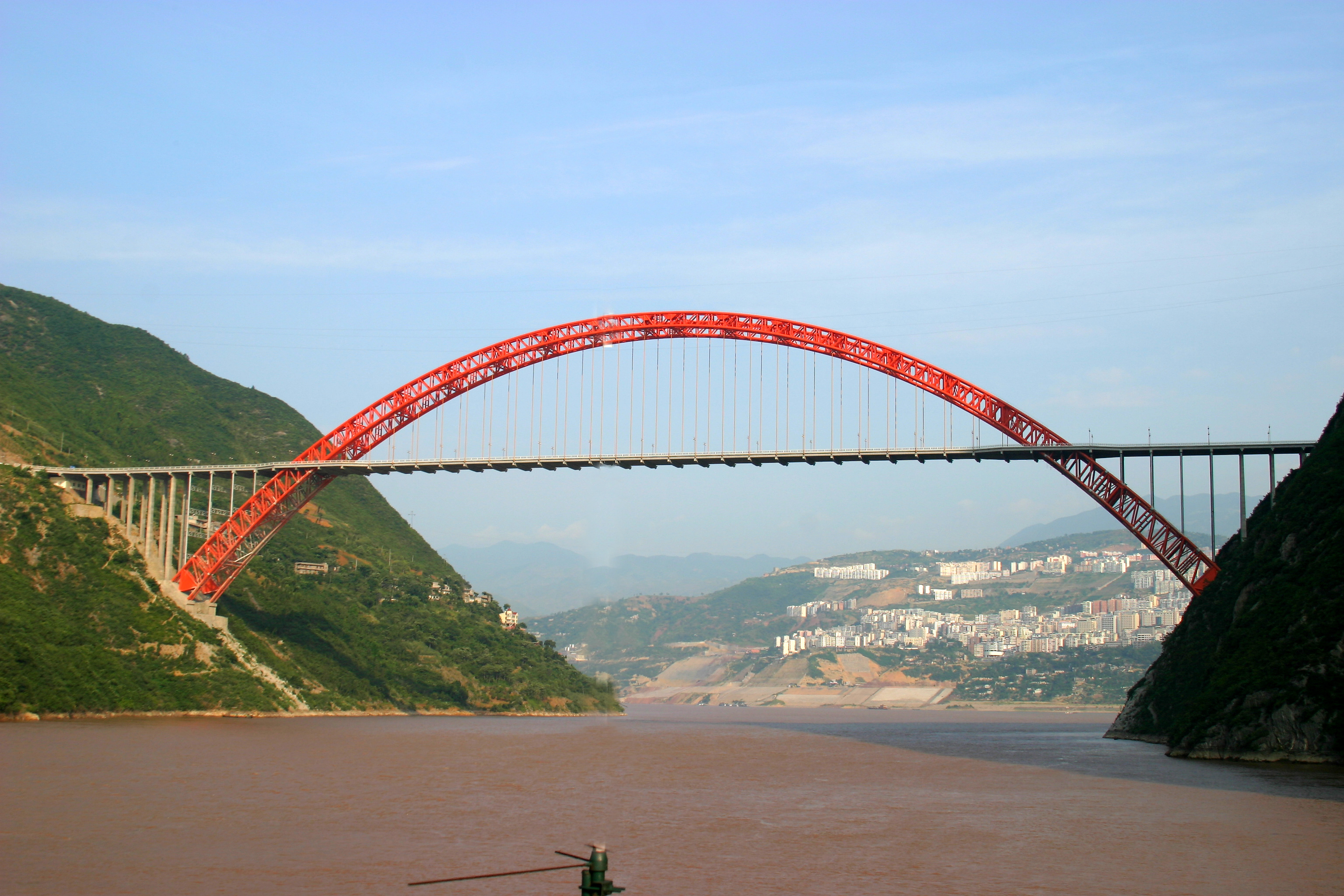
The Yichang Yangtze River Railway Bridge is an arch bridge in Yichang, Chongqing, China. The bridge was completed in 2008 and carries the Yichang−Wanzhou Railway across the Yangtze River. The bridge has two main spans of each. See also * Yangtze River bridges and tunnels The bridges and tunnels across the Yangtze River carry rail and road traffic across China's longest and largest List of rivers of China, river and form a vital part of the Transport in China, country's transportation infrastructure. The river bi ... References Bridges in Hubei Bridges completed in 2008 Bridges over the Yangtze River Railway bridges in China {{PRChina-bridge-struct-stub ... [...More Info...] [...Related Items...] OR: [Wikipedia] [Google] [Baidu] |
Bridges In Hubei
A bridge is a structure built to Span (engineering), span a physical obstacle (such as a body of water, valley, road, or railway) without blocking the path underneath. It is constructed for the purpose of providing passage over the obstacle, which is usually something that is otherwise difficult or impossible to cross. There are many different designs of bridges, each serving a particular purpose and applicable to different situations. Designs of bridges vary depending on factors such as the function of the bridge, the nature of the terrain where the bridge is constructed and anchored, the material used to make it, and the funds available to build it. The earliest bridges were likely made with fallen trees and stepping stones. The Neolithic people built boardwalk bridges across marshland. The Arkadiko Bridge, dating from the 13th century BC, in the Peloponnese is one of the oldest arch bridges in existence and use. Etymology The ''Oxford English Dictionary'' traces the origin of ... [...More Info...] [...Related Items...] OR: [Wikipedia] [Google] [Baidu] |


