|
Yavornytske
Yavornytske (), formerly Ilarionove (; ) is a rural settlement in Synelnykove Raion, Dnipropetrovsk Oblast, Ukraine. It is located midway between Dnipro and Synelnykove. Yavornytske hosts the administration of Ilarionove settlement hromada, one of the hromadas of Ukraine. Population: History Until 26 January 2024, Ilarionove was designated urban-type settlement. On this day, a new law entered into force which abolished this status, and Ilarionove became a rural settlement. On 19 September 2024, the Verkhovna Rada voted to rename Ilarionove to Yavornytske. Economy Transportation The settlement has access to Highway M18 connecting Kharkiv with Zaporizhzhia and Melitopol Melitopol is a city and municipality in Zaporizhzhia Oblast, southeastern Ukraine. It is situated on the Molochna River, which flows through the eastern edge of the city into the Molochnyi Lyman estuary. Melitopol is the second-largest city .... It is also connected by road with Dnipro. Ilarionove rai ... [...More Info...] [...Related Items...] OR: [Wikipedia] [Google] [Baidu] |
Synelnykove Raion
Synelnykove Raion () is a Raions of Ukraine, raion (district) of Dnipropetrovsk Oblast, southeastern-central Ukraine. Its administrative centre is located at Synelnykove. Population: On 18 July 2020, as part of the administrative reform of Ukraine, the number of raions of Dnipropetrovsk Oblast was reduced to seven, and the area of Synelnykove Raion was significantly expanded. Four abolished raions, Mezhova Raion, Mezhova, Petropavlivka Raion, Petropavlivka, Pokrovske Raion, Pokrovske, and Vasylkivka Raions, as well as the cities of Pershotravensk (later renamed to Shakhtarske) and Synelnykove, which were previously incorporated as City of regional significance (Ukraine), cities of oblast significance and did not belong to the raion, were merged into Synelnykove Raion. The January 2020 estimate of the raion population was Subdivisions Current After the reform in July 2020, the raion consists of 19 hromadas: * Bohynivka rural hromada with the administration in the Village#Ukraine, ... [...More Info...] [...Related Items...] OR: [Wikipedia] [Google] [Baidu] |
List Of Sovereign States
The following is a list providing an overview of sovereign states around the world with information on their status and recognition of their sovereignty. The 205 listed states can be divided into three categories based on membership within the United Nations System: 193 member states of the United Nations, UN member states, two United Nations General Assembly observers#Current non-member observers, UN General Assembly non-member observer states, and ten other states. The ''sovereignty dispute'' column indicates states having undisputed sovereignty (188 states, of which there are 187 UN member states and one UN General Assembly non-member observer state), states having disputed sovereignty (15 states, of which there are six UN member states, one UN General Assembly non-member observer state, and eight de facto states), and states having a political status of the Cook Islands and Niue, special political status (two states, both in associated state, free association with New ... [...More Info...] [...Related Items...] OR: [Wikipedia] [Google] [Baidu] |
Ukraine
Ukraine is a country in Eastern Europe. It is the List of European countries by area, second-largest country in Europe after Russia, which Russia–Ukraine border, borders it to the east and northeast. Ukraine also borders Belarus to the north; Poland and Slovakia to the west; Hungary, Romania and Moldova to the southwest; and the Black Sea and the Sea of Azov to the south and southeast. Kyiv is the nation's capital and List of cities in Ukraine, largest city, followed by Kharkiv, Odesa, and Dnipro. Ukraine's official language is Ukrainian language, Ukrainian. Humans have inhabited Ukraine since 32,000 BC. During the Middle Ages, it was the site of early Slavs, early Slavic expansion and later became a key centre of East Slavs, East Slavic culture under the state of Kievan Rus', which emerged in the 9th century. Kievan Rus' became the largest and most powerful realm in Europe in the 10th and 11th centuries, but gradually disintegrated into rival regional powers before being d ... [...More Info...] [...Related Items...] OR: [Wikipedia] [Google] [Baidu] |
Administrative Divisions Of Ukraine
The administrative divisions of Ukraine ( ) are under the jurisdiction of the Constitution of Ukraine, Ukrainian Constitution. Ukraine is a unitary state with three levels of administrative divisions: 27 regions (24 Oblasts of Ukraine, oblasts, two City with special status, cities with special status and one Autonomous Republic of Crimea, autonomous republic), 136 raions of Ukraine, raions (districts) and 1469 hromadas. The administrative reform of July 2020 merged most of the 490 legacy raions and 118 pre-2020 City of regional significance (Ukraine), cities of regional significance into 136 reorganized raions, or districts of Ukraine. The next level below raions are hromadas. Following the annexation of Crimea by the Russian Federation, annexations of Crimea and Annexation of southeastern Ukraine by the Russian Federation, southeastern Ukraine by the Russian Federation, Autonomous Republic of Crimea and Sevastopol as well as portions of Donetsk Oblast, Donetsk, Kherson Oblast ... [...More Info...] [...Related Items...] OR: [Wikipedia] [Google] [Baidu] |
Raions Of Ukraine
A raion (; ), often translated as district, is the second-level Administrative divisions of Ukraine, administrative division in Ukraine. Raions were created in a 1922 administrative reform of the Soviet Union, to which Ukraine, as the Ukrainian Soviet Socialist Republic, belonged. On 17 July 2020, the Verkhovna Rada (Ukraine's parliament) approved an administrative reform to merge most of the 490 raions, along with the "City of regional significance (Ukraine), cities of regional significance", which were previously outside the raions, into just 136 reformed raions. Most tasks of the raions (education, healthcare, sport facilities, culture, and social welfare) were taken over by new hromadas, the subdivisions of raions.Where did 354 ... [...More Info...] [...Related Items...] OR: [Wikipedia] [Google] [Baidu] |
Dnipro
Dnipro is Ukraine's fourth-largest city, with about one million inhabitants. It is located in the eastern part of Ukraine, southeast of the Ukrainian capital Kyiv on the Dnieper River, Dnipro River, from which it takes its name. Dnipro is the Capital (political), administrative centre of Dnipropetrovsk Oblast. It hosts the administration of Dnipro urban hromada. Dnipro has a population of Archeological evidence suggests the site of the present city was settled by Cossacks, Cossack communities from at least 1524. Yekaterinoslav ("glory of Catherine") was established by decree of the Emperor of all the Russias, Russian Empress Catherine the Great in 1787 as the administrative center of Novorossiya Governorate, Novorossiya. From the end of the 19th century, the town attracted foreign capital and an international, multi-ethnic workforce exploiting Kryvbas iron ore and Donbas coal. Renamed Dnipropetrovsk in 1926 after the Ukrainian Communist Party of the Soviet Union, Communist ... [...More Info...] [...Related Items...] OR: [Wikipedia] [Google] [Baidu] |
Synelnykove
Synelnykove (, ) is a city and municipality in Dnipropetrovsk Oblast, Ukraine. It is the largest city in the south-eastern part of the region. It serves as the administrative center of Synelnykove Raion within the oblast. It is named after the Russian governor Ivan Sinelnikov. Population: History It was created as a settlement in Yekaterinoslav Governorate in the 19th century on a private territory that was given as a gift to the Russian governor Ivan Sinelnikov by the Russian Imperial government. August 1868 is considered to be the official date of establishment, Synelnykove was then nothing more than a train station. It was named in honor of the noble Synelnikov family, who owned these lands until the end of the 18th century. In 1896, the train station was connected to the Kursk-Kharkiv-Sevastopol railways and was officially opened on 15 November 1873. With the development of the railway Synelnykove became an important transport hub. Industry and trade began to develop in the ... [...More Info...] [...Related Items...] OR: [Wikipedia] [Google] [Baidu] |
Dnipropetrovsk Oblast
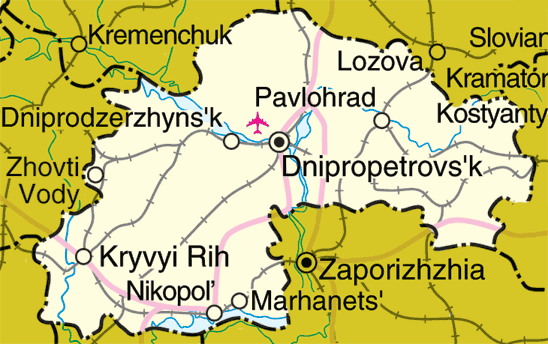
Dnipropetrovsk Oblast (), is an administrative divisions of Ukraine, oblast (province) in simultaneously southern, eastern and central Ukraine, the most important industrial region of the country. It was created on February 27, 1932. Dnipropetrovsk Oblast has a population of about approximately 80% of whom live centering on administrative centers: Dnipro, Kryvyi Rih, Kamianske, Nikopol, Ukraine, Nikopol and Pavlohrad. The Dnieper, Dnieper River runs through the oblast. Geography Most of Dnipropetrovsk Oblast, including Dnipro Raion, is located in eastern Ukraine, though some parts are in central Ukraine, central and southern Ukraine, such as Kamianske Raion and Nikopol Raion, respectively. The area of the oblast (31,974 km2) comprises about 5.3% of the total area of the country. Its longitude from north to south is 130 km, from east to west – 300 km. The oblast borders the Poltava Oblast, Poltava and Kharkiv Oblast, Kharkiv oblasts on the north, the Donetsk Obla ... [...More Info...] [...Related Items...] OR: [Wikipedia] [Google] [Baidu] |
Hromada
In Ukraine, a hromada () is the main type of municipality and the third level Administrative divisions of Ukraine, local self-government in Ukraine. The current hromadas were established by the Cabinet of ministers of Ukraine, Government of Ukraine on 12 June 2020. A municipality is designated ''urban hromada'' if its administration is located in a city; ''settlement hromada'' if it is located in a settlement (''selyshche''), and ''rural hromada'' if it is located in a village (Village#Ukraine, ''selo'') or a ''selyshche''. Hromadas are grouped to form Raions of Ukraine, raions (districts); groups of raions form Oblasts of Ukraine, oblasts (regions). Optionally, a municipality may be divided into Starosta okruh, starosta okruhs (similar to Civil parish, civil parishes in Great Britain or Frazione, frazioni in Italy), which are the lowest level of local government in Ukraine. Similar terms exist in Poland (''gromada'') and in Belarus (''hramada''). The literal translation of th ... [...More Info...] [...Related Items...] OR: [Wikipedia] [Google] [Baidu] |
Urban-type Settlement
Urban-type settlement, abbreviated: ; , abbreviated: ; ; ; ; . is an official designation for lesser urbanized settlements, used in several Central and Eastern Europe, Central and Eastern European countries. The term was primarily used in the Soviet Union and later also for a short time in People's Republic of Bulgaria, socialist Bulgaria and Polish People's Republic, socialist Poland. It remains in use today in nine of the post-Soviet states. The designation was used in all 15 member republics of the Soviet Union from 1922. It was introduced later in Poland (1954) and Bulgaria (1964). All the urban-type settlements in Poland were transformed into other types of settlement (town or village) in 1972. In Bulgaria and five of the post-Soviet republics (Armenia, Moldova, and the three Baltic states), they were changed in the early 1990s, while Ukraine followed suit in 2023. Today, this term is still used in the other nine post-Soviet republics – Azerbaijan, Belarus, Georgia (co ... [...More Info...] [...Related Items...] OR: [Wikipedia] [Google] [Baidu] |


