|
Whitehawk Camp
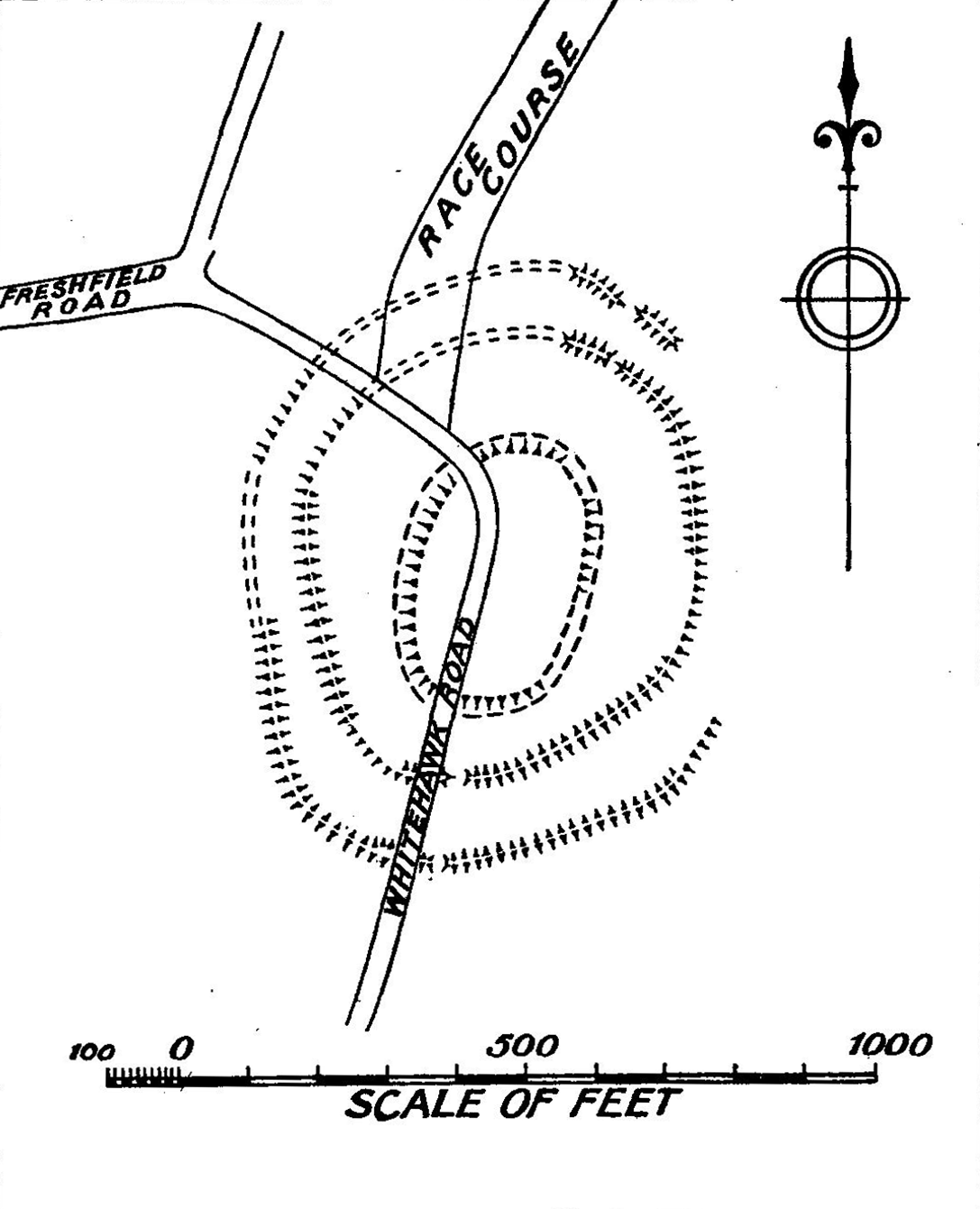
Whitehawk Camp is the remains of a causewayed enclosure on Whitehawk Hill near Brighton, East Sussex, England. Causewayed enclosures are a form of early Neolithic earthwork that were built in England from shortly before 3700 BC until at least 3500 BC, characterized by the full or partial enclosure of an area with ditches that are interrupted by gaps, or causeways. Their purpose is not known; they may have been settlements, or meeting places, or ritual sites. The Whitehawk site consists of four roughly concentric circular ditches, with banks of earth along the interior of the ditches evident in some places. There may have been a timber palisade on top of the banks. Outside the outermost circuit there are at least two more ditches, one of which is thought from radiocarbon evidence to date to the Bronze Age, about two thousand years after the earliest dated activity at the site. Whitehawk was first excavated by R. P. Ross Williamson and E. Cecil Curwen in 1929 in response to a plan ... [...More Info...] [...Related Items...] OR: [Wikipedia] [Google] [Baidu] |
Brighton
Brighton ( ) is a seaside resort in the city status in the United Kingdom, city of Brighton and Hove, East Sussex, England, south of London. Archaeological evidence of settlement in the area dates back to the Bronze Age Britain, Bronze Age, Roman conquest of Britain, Roman and Anglo-Saxons, Anglo-Saxon periods. The ancient settlement of "Brighthelmstone" was documented in the ''Domesday Book'' (1086). The town's importance grew in the Middle Ages as the Old Town developed, but it languished in the early modern period, affected by foreign attacks, storms, a suffering economy and a declining population. Brighton began to attract more visitors following improved road transport to London and becoming a boarding point for boats travelling to France. The town also developed in popularity as a health resort for sea bathing as a purported cure for illnesses. In the Georgian era, Brighton developed as a highly fashionable seaside resort, encouraged by the patronage of the Prince Regent ... [...More Info...] [...Related Items...] OR: [Wikipedia] [Google] [Baidu] |
Neolithic British Isles
The Neolithic period in the British Isles lasted from 4100 to 2,500 Before Christ, BC. Constituting the final stage of the Stone Age in the region, it was preceded by the Mesolithic and followed by the Bronze Age Britain, Bronze Age. During the Mesolithic period, the inhabitants of the British Isles had been hunter-gatherers. Around 4000 BC, migrants began arriving from Central Europe. These migrants brought new ideas, leading to a radical transformation of society and landscape that has been called the Neolithic Revolution. The Neolithic period in the British Isles was characterised by the adoption of agriculture and sedentism, sedentary living. To make room for the new farmland, the early agricultural communities undertook mass deforestation across the islands, which dramatically and permanently transformed the landscape. At the same time, new types of stone tools requiring more skill began to be produced, and new technologies included polishing. Although the earliest indis ... [...More Info...] [...Related Items...] OR: [Wikipedia] [Google] [Baidu] |
Windmill Hill, Avebury
Windmill Hill is a Neolithic causewayed enclosure in the English county of Wiltshire, part of the Avebury World Heritage Site, about 1 mile (2 km) northwest of Avebury. Enclosing an area of , it is the largest known causewayed enclosure in Britain. The site was first occupied around 3800 BC, although the only evidence is a series of pits apparently dug by an agrarian society using Hembury pottery. During a later phase, c. 3700 BC, three concentric segmented ditches were placed around the hilltop site, the outermost with a diameter of 365 metres. The causeways interrupting the ditches vary in width from a few centimetres to 7 m. Material from the ditches was piled up to create internal banks; the deepest ditches and largest banks are on the outer circuit. In the same period there was also a rectangular mortuary enclosure. The site was designated as a scheduled monument in 1925. It came into the ownership of the National Trust in 1942 and is under the guardianship of Englis ... [...More Info...] [...Related Items...] OR: [Wikipedia] [Google] [Baidu] |
Knap Hill
Knap Hill lies on the northern rim of the Vale of Pewsey, in northern Wiltshire, England, about a mile (1.6 km) north of the village of Alton Priors. At the top of the hill is a causewayed enclosure, a form of Neolithic earthwork that was constructed in England from about 3700 BC onwards, characterized by the full or partial enclosure of an area with ditches that are interrupted by gaps, or causeways. Their purpose is not known: they may have been settlements, or meeting places, or ritual sites of some kind. The site has been scheduled as an ancient monument. Knap Hill is notable as the first causewayed enclosure to be excavated and identified. In 1908 and 1909, Benjamin and Maud Cunnington spent two summers investigating the site, and Maud published two reports of their work, noting that there were several gaps in the ditch and bank surrounding the enclosure. In the late 1920s, after the excavation of Windmill Hill and other sites, it became apparent that causewayed enclo ... [...More Info...] [...Related Items...] OR: [Wikipedia] [Google] [Baidu] |
The Trundle
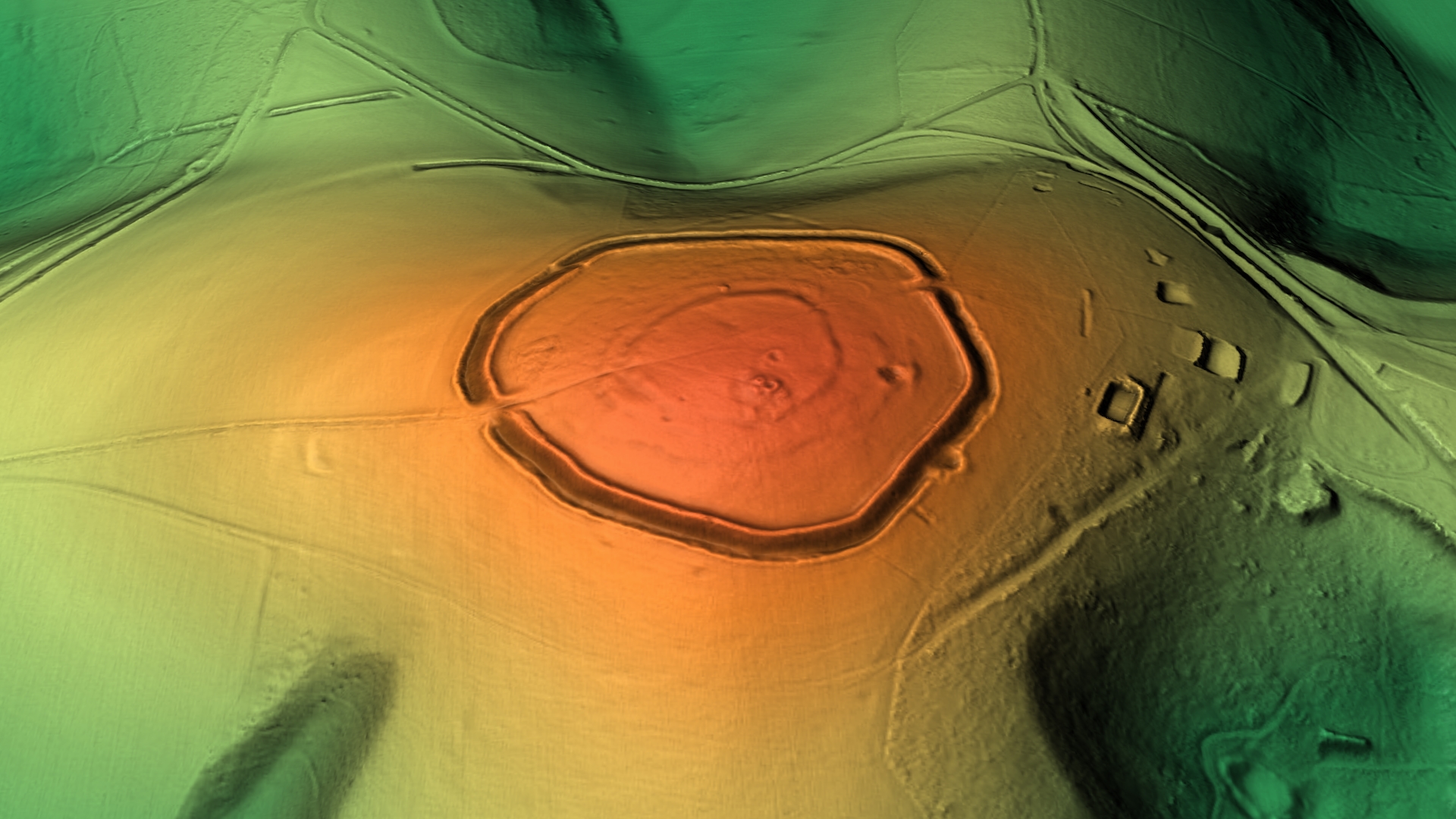
The Trundle is an Iron Age hillfort on St Roche's Hill about north of Chichester, West Sussex, England. It was built on the site of a causewayed enclosure, a form of early Neolithic earthwork found in northwestern Europe. Causewayed enclosures were built in England from shortly before 3700 BC until at least 3500 BC; they are characterized by the full or partial enclosure of an area with ditches that are interrupted by gaps, or causeways. Their purpose is not known; they may have been settlements, meeting places, or ritual sites. Hillforts were built as early as 1000 BC, in the Late Bronze Age, and continued to be built through the Iron Age until shortly before the Roman occupation. A chapel dedicated to St Roche was built on the hill around the end of the 14th century; it was in ruins by 1570. A windmill and a beacon were subsequently built on the hill. The site was occasionally used as a meeting place in the post-medieval period. The hillfort is still a substantial ... [...More Info...] [...Related Items...] OR: [Wikipedia] [Google] [Baidu] |
Mollusc
Mollusca is a phylum of protostome, protostomic invertebrate animals, whose members are known as molluscs or mollusks (). Around 76,000 extant taxon, extant species of molluscs are recognized, making it the second-largest animal phylum after Arthropoda. The number of additional fossil species is estimated between 60,000 and 100,000, and the proportion of undescribed species is very high. Many taxa remain poorly studied. Molluscs are the largest marine biology, marine phylum, comprising about 23% of all the named marine organisms. They are highly diverse, not just in size and anatomical structure, but also in behaviour and habitat, as numerous groups are freshwater mollusc, freshwater and even terrestrial molluscs, terrestrial species. The phylum is typically divided into 7 or 8 taxonomy (biology), taxonomic class (biology), classes, of which two are entirely extinct. Cephalopod molluscs, such as squid, cuttlefish, and octopuses, are among the most neurobiology, neurologi ... [...More Info...] [...Related Items...] OR: [Wikipedia] [Google] [Baidu] |
Long Barrow
Long barrows are a style of monument constructed across Western Europe in the fifth and fourth millennia BCE, during the Early Neolithic period. Typically constructed from earth and either timber or stone, those using the latter material represent the oldest widespread tradition of stone construction in the world. Around 40,000 long barrows survive today. The structures have a long earthen tumulus, or "barrow", that is flanked on two sides with linear ditches. These typically stretch for between 20 and 70 metres in length, although some exceptional examples are either longer or shorter than this. Some examples have a timber or stone chamber in one end of the tumulus. These monuments often contained human remains interred within their chambers, and as a result, are often interpreted as tombs, although there are some examples where this appears not to be the case. The choice of timber or stone may have arisen from the availability of local materials rather than cultural difference ... [...More Info...] [...Related Items...] OR: [Wikipedia] [Google] [Baidu] |
Round Barrow
A round barrow is a type of tumulus and is one of the most common types of archaeological monuments. Although concentrated in Europe, they are found in many parts of the world, probably because of their simple construction and universal purpose. In Britain, most of them were built between 2200BC and 1100BC. This was the Late Neolithic period to the Late Bronze Age. Later Iron Age barrows were mostly different, and sometimes square. Description At its simplest, a round barrow is a hemispherical mound of earth and/or stone raised over a burial placed in the middle. Beyond this there are numerous variations which may employ surrounding ditches, stone kerbs or flat berms between ditch and mound. Construction methods range from a single creation process of heaped material to a complex depositional sequence involving alternating layers of stone, soil and turf with timbers or wattle used to help hold the structure together. The center may be placed a stone chamber or cist or in ... [...More Info...] [...Related Items...] OR: [Wikipedia] [Google] [Baidu] |
Saddle (landform)
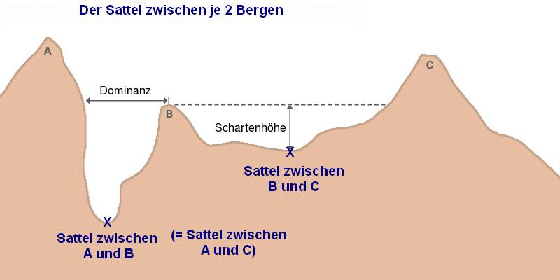
The saddle between two hills or mountains is the region surrounding the saddle point, the lowest point on the line tracing the drainage divide (the col) connecting the peaks. When, and if, the saddle is navigable, even if only on foot, the saddle of a (optimal) mountain pass, pass between the two massifs, is the area generally found around the lowest route on which one could pass between the two summits, which includes that point which is a mathematically when graphed a Maxima and minima, relative high along one axis, and a Maxima and minima, relative low in the perpendicular axis, simultaneously; that point being by definition the col of the saddle. Topography A saddle is the lowest area between two highlands (prominences or peaks) which has two wings which span the divide (the line between the two prominences) by crossing the divide at an angle, and, so is concurrently the local highpoint of the land surface which falls off in the lower direction. That is, the drainage divide ... [...More Info...] [...Related Items...] OR: [Wikipedia] [Google] [Baidu] |
Chalk Group
The Chalk Group (often just called the Chalk) is the lithostratigraphic unit (a certain number of rock strata) which contains the Upper Cretaceous limestone succession in southern and eastern England. The same or similar rock sequences occur across the wider northwest European chalk 'province'. It is characterised by thick deposits of chalk, a soft porous white limestone, deposited in a marine environment. Chalk is a limestone that consists of coccolith biomicrite. A biomicrite is a limestone composed of fossil debris ("bio") and calcium carbonate mud (" micrite"). Most of the fossil debris in chalk consists of the microscopic plates, which are called coccoliths, of microscopic green algae known as coccolithophores. In addition to the coccoliths, the fossil debris includes a variable, but minor, percentage of the fragments of foraminifera, ostracods and mollusks. The coccolithophores lived in the upper part of the water column. When they died, the microscopic calcium carbonat ... [...More Info...] [...Related Items...] OR: [Wikipedia] [Google] [Baidu] |
Toms Allcroft Whitehawk Plan 1916
Toms, Tom's or TOMS may refer to: People * Billy Toms (1895–unknown), Irish footballer * Carl Toms (1927–1999), British set and costume designer * David Toms (born 1967), American golfer on the PGA tour * Edward Toms (1899–1971), British athlete * Elaine Toms (other), multiple people :* Elaine G. Toms, Canadian and British information scientist :* M. Elaine Toms (1917–2019), Korean-born American physicist * Eric Toms (born 1979), American comedian * Frederick Toms (1885–1965), Canadian rower * Ivan Toms (1953–2008), South African physician and political activist * Jeff Toms (born 1974), Canadian ice hockey player * Kevin Toms, computer game designer * Peter Toms (painter) (c. 1728-1777), English portrait and drapery painter * Samuel Toms (c. 1842–1907), founder of Good, Toms & Co, South Australian wholesaler * Wendy Toms (born 1962), English football referee * William Henry Toms (c. 1700–1765), English engraver * Toms Hartmanis (born 1987), Latvian ... [...More Info...] [...Related Items...] OR: [Wikipedia] [Google] [Baidu] |
Chalk
Chalk is a soft, white, porous, sedimentary carbonate rock. It is a form of limestone composed of the mineral calcite and originally formed deep under the sea by the compression of microscopic plankton that had settled to the sea floor. Chalk is common throughout Western Europe, where deposits underlie parts of France, and steep cliffs are often seen where they meet the sea in places such as the Dover cliffs on the Kent coast of the English Channel. Chalk is mined for use in industry, such as for quicklime, bricks and builder's putty, and in agriculture, for raising pH in soils with high acidity. It is also used for " blackboard chalk" for writing and drawing on various types of surfaces, although these can also be manufactured from other carbonate-based minerals, or gypsum. Description Chalk is a fine-textured, earthy type of limestone distinguished by its light colour, softness, and high porosity. It is composed mostly of tiny fragments of the calcite shells or sk ... [...More Info...] [...Related Items...] OR: [Wikipedia] [Google] [Baidu] |


