|
Whinhill Lock
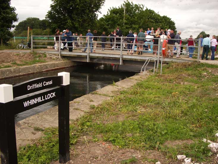
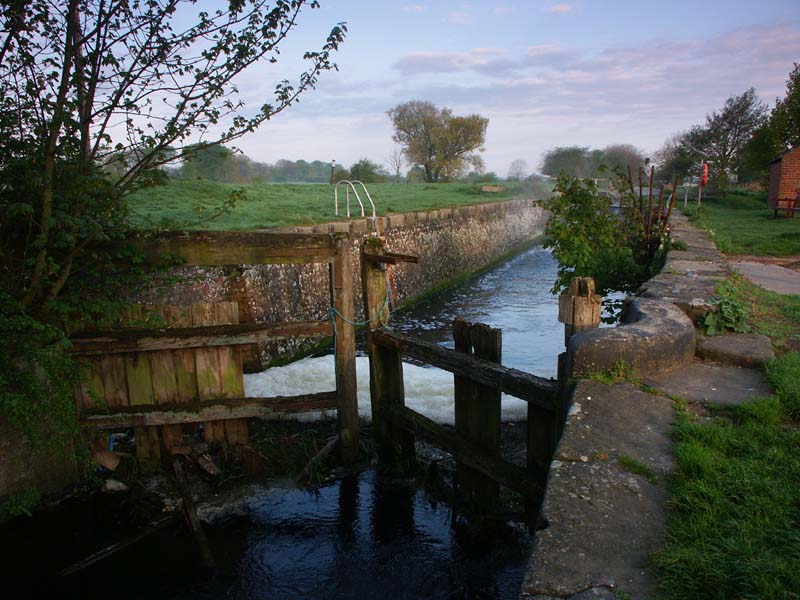
Whinhill Lock was built as part of the Driffield Navigation in the East Riding of Yorkshire, England. It was originally opened in 1770, and was restored in 2004. Location Located between the village of Wansford and town of Driffield, the lock is easily accessible from the B1249 road. ;Situated on the Driffield Navigation *Next Place Upstream: Town Lock *Next Place Downstream: Wansford Lock History The lock was built during the construction of the Driffield Navigation between 1767 and 1770, and is a grade II listed structure. After the last traffic to Driffield stopped around 1945 the lock gradually fell into disrepair. In 1968 the Driffield Navigation Amenities Association started to restore and maintain the canal and its structures. Various "working parties" have been held at the lock over the years, to conserve the structure, but in 2004 a lottery grant was secured to restore and re-gate it. The lock was reopened by the Mayor of Driffield Mrs Margaret Killin on 25 June 2 ... [...More Info...] [...Related Items...] OR: [Wikipedia] [Google] [Baidu] |
Wansford Lock
Wansford Lock was built as part of the Driffield Navigation in the East Riding of Yorkshire, England. It was opened in 1770, and restored in 2009. It was designated Grade II in 1985. Location In the village of Wansford, the lock is easily accessible from the B1249 road. ;Situated on the Driffield Navigation *Next Place Upstream: Whinhill Lock *Next Place Downstream: Wansford Bridge History The lock was built during the construction of the Driffield Navigation between 1767 and 1770. It was restored in two stages, the first of which involved the creation of a flood relief channel around the lock chamber, which was completed in Autumn 2008. New top and bottom gates were installed as part of the second phase, and the lock was officially opened on 4 July 2009. The funding for this project was provided by the Inland Waterways Association, the East Riding of Yorkshire Council, and Waste Recycling Environmental Limited (WREN), who give grants to organisations based near to landfill ... [...More Info...] [...Related Items...] OR: [Wikipedia] [Google] [Baidu] |
Transport In The East Riding Of Yorkshire
Transport (in British English), or transportation (in American English), is the intentional movement of humans, animals, and goods from one location to another. Modes of transport include air, land ( rail and road), water, cable, pipeline, and space. The field can be divided into infrastructure, vehicles, and operations. Transport enables human trade, which is essential for the development of civilizations. Transport infrastructure consists of both fixed installations, including roads, railways, airways, waterways, canals, and pipelines, and terminals such as airports, railway stations, bus stations, warehouses, trucking terminals, refueling depots (including fueling docks and fuel stations), and seaports. Terminals may be used both for interchange of passengers and cargo and for maintenance. Means of transport are any of the different kinds of transport facilities used to carry people or cargo. They may include vehicles, riding animals, and pack animals. Vehicles ma ... [...More Info...] [...Related Items...] OR: [Wikipedia] [Google] [Baidu] |
Buildings And Structures In The East Riding Of Yorkshire
A building, or edifice, is an enclosed structure with a roof and walls standing more or less permanently in one place, such as a house or factory (although there's also portable buildings). Buildings come in a variety of sizes, shapes, and functions, and have been adapted throughout history for a wide number of factors, from building materials available, to weather conditions, land prices, ground conditions, specific uses, prestige, and aesthetic reasons. To better understand the term ''building'' compare the list of nonbuilding structures. Buildings serve several societal needs – primarily as shelter from weather, security, living space, privacy, to store belongings, and to comfortably live and work. A building as a shelter represents a physical division of the human habitat (a place of comfort and safety) and the ''outside'' (a place that at times may be harsh and harmful). Ever since the first cave paintings, buildings have also become objects or canvasses of much artist ... [...More Info...] [...Related Items...] OR: [Wikipedia] [Google] [Baidu] |
Canal Lock
A lock is a device used for raising and lowering boats, ships and other watercraft between stretches of water of different levels on river and canal waterways. The distinguishing feature of a lock is a fixed chamber in which the water level can be varied; whereas in a caisson lock, a boat lift, or on a canal inclined plane, it is the chamber itself (usually then called a caisson) that rises and falls. Locks are used to make a river more easily navigable, or to allow a canal to cross land that is not level. Later canals used more and larger locks to allow a more direct route to be taken. Pound lock A ''pound lock'' is most commonly used on canals and rivers today. A pound lock has a chamber with gates at both ends that control the level of water in the pound. In contrast, an earlier design with a single gate was known as a flash lock. Pound locks were first used in China during the Song Dynasty (960–1279 AD), having been pioneered by the Song politician and naval ... [...More Info...] [...Related Items...] OR: [Wikipedia] [Google] [Baidu] |
Mayor
In many countries, a mayor is the highest-ranking official in a municipal government such as that of a city or a town. Worldwide, there is a wide variance in local laws and customs regarding the powers and responsibilities of a mayor as well as the means by which a mayor is elected or otherwise mandated. Depending on the system chosen, a mayor may be the chief executive officer of the municipal government, may simply chair a multi-member governing body with little or no independent power, or may play a solely ceremonial role. A mayor's duties and responsibilities may be to appoint and oversee municipal managers and employees, provide basic governmental services to constituents, and execute the laws and ordinances passed by a municipal governing body (or mandated by a state, territorial or national governing body). Options for selection of a mayor include direct election by the public, or selection by an elected governing council or board. The term ''mayor'' shares a linguistic o ... [...More Info...] [...Related Items...] OR: [Wikipedia] [Google] [Baidu] |
Driffield Navigation Amenities Association
Driffield, also known as Great Driffield, is a market town and civil parish in the East Riding of Yorkshire, England. The civil parish is formed by the town of Driffield and the village of Little Driffield. By road, it is north-east of Leeds, north-east of Sheffield, east of York, north of Hull and south-east of Middlesbrough. Driffield is named ''The Capital of the Wolds'', due to its location sitting centrally within the Yorkshire Wolds. According to the 2011 UK census, Driffield parish had a population of 13,080, an increase on the 2001 UK census figure of 11,477. The town was listed in the 2019 Sunday Times report on the Best Places to Live in northern England. History Driffield is of Anglo-Saxon origin, and the name is first attested in the ''Anglo-Saxon Chronicle'' where King Aldfrith of Northumbria died on the 14 December 705. It is also found in ''Domesday Book'' of 1086, meaning "dirty (manured) field". A Bronze Age mound outside Driffield was excavated in ... [...More Info...] [...Related Items...] OR: [Wikipedia] [Google] [Baidu] |
Grade II Listed
In the United Kingdom, a listed building or listed structure is one that has been placed on one of the four statutory lists maintained by Historic England in England, Historic Environment Scotland in Scotland, in Wales, and the Northern Ireland Environment Agency in Northern Ireland. The term has also been used in the Republic of Ireland, where buildings are protected under the Planning and Development Act 2000. The statutory term in Ireland is "protected structure". A listed building may not be demolished, extended, or altered without special permission from the local planning authority, which typically consults the relevant central government agency, particularly for significant alterations to the more notable listed buildings. In England and Wales, a national amenity society must be notified of any work to a listed building which involves any element of demolition. Exemption from secular listed building control is provided for some buildings in current use for worship ... [...More Info...] [...Related Items...] OR: [Wikipedia] [Google] [Baidu] |
Town Lock
A town is a human settlement. Towns are generally larger than villages and smaller than cities, though the criteria to distinguish between them vary considerably in different parts of the world. Origin and use The word "town" shares an origin with the German word , the Dutch word , and the Old Norse . The original Proto-Germanic word, *''tūnan'', is thought to be an early borrowing from Proto-Celtic *''dūnom'' (cf. Old Irish , Welsh ). The original sense of the word in both Germanic and Celtic was that of a fortress or an enclosure. Cognates of ''town'' in many modern Germanic languages designate a fence or a hedge. In English and Dutch, the meaning of the word took on the sense of the space which these fences enclosed, and through which a track must run. In England, a town was a small community that could not afford or was not allowed to build walls or other larger fortifications, and built a palisade or stockade instead. In the Netherlands, this space was a gar ... [...More Info...] [...Related Items...] OR: [Wikipedia] [Google] [Baidu] |
Driffield Navigation
The Driffield Navigation is an waterway, through the heart of the Holderness Plain to the market town of Driffield, East Riding of Yorkshire, England. The northern section of it is a canal, and the southern section is part of the River Hull. Construction was authorised in 1767, and it was fully open in 1770. Early use of the navigation was hampered by a small bridge at Hull Bridge, which was maintained by Beverley Corporation. After protracted negotiation, it was finally replaced in 1804, and a new lock was built to improve water levels at the same time. One curious feature of the new works were that they were managed quite separately for many years, with the original navigation called the Old Navigation, and the new works called the New Navigation. They were not fully amalgamated until 1888. The navigation gradually became more profitable, and although railways arrived at Driffield in 1846, the navigation continued to prosper and increase its traffic until the 1870s, after wh ... [...More Info...] [...Related Items...] OR: [Wikipedia] [Google] [Baidu] |
B1249 Road
B roads are numbered routes in Great Britain of lesser importance than A roads. See the article Great Britain road numbering scheme The Great Britain road numbering scheme is a numbering scheme used to classify and identify all roads in Great Britain. Each road is given a single letter (which represents the road's category) and a subsequent number (between 1 and 4 digits). ... for the rationale behind the numbers allocated. Zone 1 (3 digits) Zone 1 (4 digits) {{DEFAULTSORT:B Roads In Zone 1 Of The Great Britain Numbering Scheme 1 1 ... [...More Info...] [...Related Items...] OR: [Wikipedia] [Google] [Baidu] |
Driffield
Driffield, also known as Great Driffield, is a market town and civil parish in the East Riding of Yorkshire, England. The civil parish is formed by the town of Driffield and the village of Little Driffield. By road, it is north-east of Leeds, north-east of Sheffield, east of York, north of Hull and south-east of Middlesbrough. Driffield is named ''The Capital of the Wolds'', due to its location sitting centrally within the Yorkshire Wolds. According to the 2011 UK census, Driffield parish had a population of 13,080, an increase on the 2001 UK census figure of 11,477. The town was listed in the 2019 Sunday Times report on the Best Places to Live in northern England. History Driffield is of Anglo-Saxon origin, and the name is first attested in the ''Anglo-Saxon Chronicle'' where King Aldfrith of Northumbria died on the 14 December 705. It is also found in ''Domesday Book'' of 1086, meaning "dirty (manured) field". A Bronze Age mound outside Driffield was excavated i ... [...More Info...] [...Related Items...] OR: [Wikipedia] [Google] [Baidu] |


.jpg)
