|
Waihou
Waihou is a rural settlement in the Matamata-Piako District and Waikato region of New Zealand's North Island. It is located on between Te Aroha and Morrinsville and west of the Waihou River. Waihou Recreational Reserve provides sporting facilities. At the beginning of the 20th century, Waihou had a population of about 100, a railway siding and a primary school. Demographics Statistics New Zealand describes Waihou as a rural settlement, which covers . Waihou is part of the larger Waihou-Manawaru statistical area. Waihou had a population of 318 at the 2018 New Zealand census, an increase of 48 people (17.8%) since the 2013 census, and an increase of 57 people (21.8%) since the 2006 census. There were 120 households, comprising 165 males and 156 females, giving a sex ratio of 1.06 males per female, with 63 people (19.8%) aged under 15 years, 54 (17.0%) aged 15 to 29, 129 (40.6%) aged 30 to 64, and 75 (23.6%) aged 65 or older. Ethnicities were 88.7% European/Pākehā, 13.2% ... [...More Info...] [...Related Items...] OR: [Wikipedia] [Google] [Baidu] |
Waihou River
The Waihou River is located in the northern North Island of New Zealand. Its former name, Thames River, was bestowed by Captain James Cook in November 1769, when he explored of the river from the mouth. An older Māori name was "Wai Kahou Rounga". A 1947 Geographic Board enquiry ruled that the official name would be Waihou. Geography The river flows north for from the Mamaku Ranges past the towns of Putāruru, Te Aroha, Paeroa and Turua, before reaching the Firth of Thames at the south end of the Hauraki Gulf near the town of Thames, New Zealand, Thames. In its lower reaches, the river and the nearby Piako River form the wide alluvial Hauraki Plains. Just before the river reaches the ocean, State Highway 25 crosses the river over the Kopu Bridge, which was the longest single lane bridge in the country at and the only remaining swing bridge on a New Zealand state highway. The bridge was infamous for the queues of vehicles travelling to and from the Coromandel Peninsula ... [...More Info...] [...Related Items...] OR: [Wikipedia] [Google] [Baidu] |
Manawaru
Manawaru or Manawarū is a rural community in the Matamata-Piako District and Waikato region of New Zealand's North Island. It is located south-east of Te Aroha and north-east of Ngarua, and includes part of the Waihou River and some of the foothills of the Kaimai Ranges. It features a bible chapel, a school, a Playcentre for early childhood education, and a community hall that can accommodate up to 200 people. Demographics Manawaru is in an SA1 statistical area which covers . The SA1 area is part of the larger Waihou-Manawaru statistical area. The SA1 area had a population of 114 at the 2018 New Zealand census, an increase of 6 people (5.6%) since the 2013 census, and a decrease of 3 people (−2.6%) since the 2006 census. There were 42 households, comprising 54 males and 57 females, giving a sex ratio of 0.95 males per female. The median age was 37.3 years (compared with 37.4 years nationally), with 24 people (21.1%) aged under 15 years, 24 (21.1%) aged 15 to 29, 54 (47.4% ... [...More Info...] [...Related Items...] OR: [Wikipedia] [Google] [Baidu] |
Te Aroha
Te Aroha ( mi, Te Aroha-a-uta) is a rural town in the Waikato region of New Zealand with a population of 3,906 people in the 2013 census, an increase of 138 people since 2006. It is northeast of Hamilton and south of Thames. It sits at the foot of Mount Te Aroha, the highest point in the Kaimai Range. History The name Te Aroha derives from the Māori name of Mount Te Aroha. In one version, Rāhiri, the eponymous ancestor of Ngāti Rāhiri Tumutumu, climbed the mountain and saw his homeland in the distance and felt a sense of love () for it. The town is properly named ; meaning 'inland', so the town is named "love flowing inland". In some Tainui traditions, Rakataura, a tohunga of the '' Tainui'' waka, was one of the first people to leave the waka, settling at Rarotonga / Mount Smart. After a period of time, Rakataura decided to leave Tāmaki Makaurau and travel south, however during the journey his wife Kahukeke died. Eventually Rakataura settled at Te Aroha, ... [...More Info...] [...Related Items...] OR: [Wikipedia] [Google] [Baidu] |
Matamata-Piako District
Matamata-Piako District is a local government area in the Waikato region of New Zealand. It lies to the east of the city of Hamilton. Geography The district encompasses the southern end of the Hauraki Plains and much of the Thames Valley, and is bounded in the east by the Kaimai Range. The rivers Piako and Waihou run through the district. The towns of Matamata, Morrinsville and Te Aroha are all within the district, with the Council's head office based in Te Aroha. The main industry in the region is dairy farming and Thoroughbred breeding and training. Other communities in the district include Mangateparu and Waitoa. Populated places Matamata-Piako District consists of the following towns, localities, settlements and communities: * Matamata Ward: ** Buckland ** Gordon ** Hinuera ** Matai ** Matamata ** Okauia South ** Okauia ** Paratu ** Peria ** Piarere ** Richmond Downs ** Selwyn ** Taihoa ** Tamihana ** Te Poi ** Turangaomoana ** '' Waharoa'' ** ... [...More Info...] [...Related Items...] OR: [Wikipedia] [Google] [Baidu] |
Waikato
Waikato () is a local government region of the upper North Island of New Zealand. It covers the Waikato District, Waipa District, Matamata-Piako District, South Waikato District and Hamilton City, as well as Hauraki, Coromandel Peninsula, the northern King Country, much of the Taupō District, and parts of Rotorua District. It is governed by the Waikato Regional Council. The region stretches from Coromandel Peninsula in the north, to the north-eastern slopes of Mount Ruapehu in the south, and spans the North Island from the west coast, through the Waikato and Hauraki to Coromandel Peninsula on the east coast. Broadly, the extent of the region is the Waikato River catchment. Other major catchments are those of the Waihou, Piako, Awakino and Mokau rivers. The region is bounded by Auckland on the north, Bay of Plenty on the east, Hawke's Bay on the south-east, and Manawatū-Whanganui and Taranaki on the south. Waikato Region is the fourth largest region in the country in ar ... [...More Info...] [...Related Items...] OR: [Wikipedia] [Google] [Baidu] |
Waikato Regional Council
Waikato () is a local government region of the upper North Island of New Zealand. It covers the Waikato District, Waipa District, Matamata-Piako District, South Waikato District and Hamilton City, as well as Hauraki, Coromandel Peninsula, the northern King Country, much of the Taupō District, and parts of Rotorua District. It is governed by the Waikato Regional Council. The region stretches from Coromandel Peninsula in the north, to the north-eastern slopes of Mount Ruapehu in the south, and spans the North Island from the west coast, through the Waikato and Hauraki to Coromandel Peninsula on the east coast. Broadly, the extent of the region is the Waikato River catchment. Other major catchments are those of the Waihou, Piako, Awakino and Mokau rivers. The region is bounded by Auckland on the north, Bay of Plenty on the east, Hawke's Bay on the south-east, and Manawatū-Whanganui and Taranaki on the south. Waikato Region is the fourth largest region in the country in ... [...More Info...] [...Related Items...] OR: [Wikipedia] [Google] [Baidu] |
Morrinsville
Morrinsville is a provincial town in the Waikato region of New Zealand's North Island, with an estimated population of as of The town is located at the northern base of the Pakaroa Range, and on the south-western fringe of the Hauraki Plains. Morrinsville is around 33 kilometres east of Hamilton and 22 kilometres west of Te Aroha. The town is bordered by the Piako River to the east and the Waitakaruru Stream to the south. History and Culture Pre-European settlement Prior to European settlement of New Zealand, the hills around present-day Morrinsville were occupied by the Ngati Werewere Māori people of the Ngati Haua Iwi, and the site of the present-day town was on or near to an old Māori route between the upper Waihou-Piako basin and the Ngāruawāhia area. Following European settlement, some early European traders are believed to have traversed this route prior to 1834 when the Rev. J. Morgan travelled up the Piako River to near the future town site and crossed w ... [...More Info...] [...Related Items...] OR: [Wikipedia] [Google] [Baidu] |
2006 New Zealand Census
The New Zealand Census of Population and Dwellings ( mi, Te Tatauranga o ngā Tāngata Huri Noa i Aotearoa me ō rātou Whare Noho) is a national population and housing census conducted by government department Statistics New Zealand every five years. There have been 34 censuses since 1851. In addition to providing detailed information about national demographics, the results of the census play an important part in the calculation of resource allocation to local service providers. The 2018 census took place on Tuesday 6 March 2018. The next census is expected in March 2023. Census date Since 1926, the census has always been held on a Tuesday and since 1966, the census always occurs in March. These are statistically the month and weekday on which New Zealanders are least likely to be travelling. The census forms have to be returned by midnight on census day for them to be valid. Conducting the census Until 2018, census forms were hand-delivered by census workers during the lead ... [...More Info...] [...Related Items...] OR: [Wikipedia] [Google] [Baidu] |
Christianity In New Zealand
Christianity in New Zealand dates to the arrival of missionaries from the Church Missionary Society who were welcomed onto the beach at Rangihoua Bay in December 1814. It soon became the predominant belief amongst the indigenous people with an estimated 60% of Māori pledging allegiance to the Christian message within the first 35 years. It remains New Zealand's largest religious group despite there being no official state church A state religion (also called religious state or official religion) is a religion or creed officially endorsed by a sovereign state. A state with an official religion (also known as confessional state), while not secular, is not necessarily a t .... Today, slightly less than half the population identify as Christians, Christian. The largest Christian groups are Catholic Church in New Zealand, Catholic, Anglican Church in Aotearoa, New Zealand and Polynesia, Anglican and Presbyterian Church in New Zealand, Presbyterian. Christian organisations are t ... [...More Info...] [...Related Items...] OR: [Wikipedia] [Google] [Baidu] |
Asian New Zealanders
Asian New Zealanders are New Zealanders of Asian ancestry (including naturalised New Zealanders who are immigrants from specific regions in Asia and descendants of such immigrants). Terminology In the New Zealand census, the term refers to a pan-ethnic group that includes diverse populations who have ancestral origins in East Asia (e.g. Chinese New Zealanders, Korean New Zealanders, Japanese New Zealanders), Southeast Asia (e.g. Filipino New Zealanders, Vietnamese New Zealanders, Malaysian New Zealanders), and South Asia (e.g. Nepalese New Zealanders, Indian New Zealanders, Sri Lankan New Zealanders, Bangladeshi New Zealanders, Pakistani New Zealanders). Notably, New Zealanders of West Asian and Central Asian ancestry are excluded from this term. Colloquial usage of ''Asian'' in New Zealand excludes Indians and other peoples of South Asian descent. ''Asian'' as used by Statistics New Zealand includes South Asian ethnic group. The first Asians in New Zealand were ... [...More Info...] [...Related Items...] OR: [Wikipedia] [Google] [Baidu] |
Pasifika New Zealanders
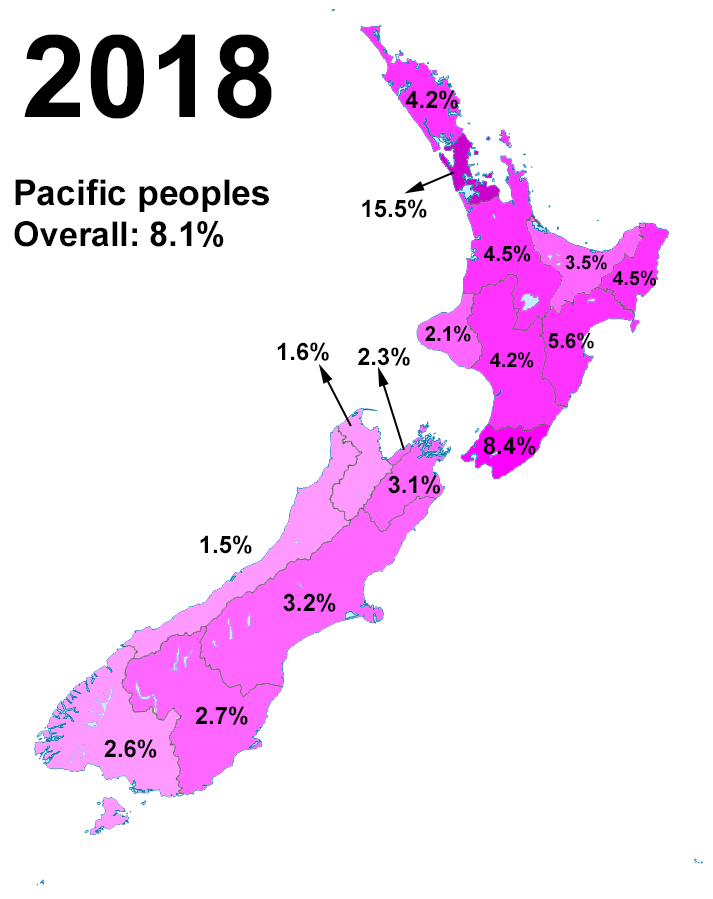
Pasifika New Zealanders are a pan-ethnic group of New Zealanders associated with, and descended from, the indigenous peoples of the Pacific Islands outside of New Zealand itself (also known as Pacific Islanders). They form the fourth-largest ethnic grouping in the country, after European-descended Pākehā, indigenous Māori, and Asian New Zealanders. There are over 380,000 Pasifika people in New Zealand, with the majority living in Auckland. 8% of the population of New Zealand identifies as being of Pacific origin. History Prior to the Second World War Pasifika in New Zealand numbered only a few hundred. Wide-scale Pasifika migration to New Zealand began in the 1950s and 1960s, typically from countries associated with the Commonwealth and the Realm of New Zealand, including Western Samoa (modern-day Samoa), the Cook Islands and Niue. In the 1970s, governments (both Labour and National), migration officials, and special police squads targeted Pasifika illegal overstayers. ... [...More Info...] [...Related Items...] OR: [Wikipedia] [Google] [Baidu] |
Māori People
The Māori (, ) are the indigenous Polynesian people of mainland New Zealand (). Māori originated with settlers from East Polynesia, who arrived in New Zealand in several waves of canoe voyages between roughly 1320 and 1350. Over several centuries in isolation, these settlers developed their own distinctive culture, whose language, mythology, crafts, and performing arts evolved independently from those of other eastern Polynesian cultures. Some early Māori moved to the Chatham Islands, where their descendants became New Zealand's other indigenous Polynesian ethnic group, the Moriori. Initial contact between Māori and Europeans, starting in the 18th century, ranged from beneficial trade to lethal violence; Māori actively adopted many technologies from the newcomers. With the signing of the Treaty of Waitangi in 1840, the two cultures coexisted for a generation. Rising tensions over disputed land sales led to conflict in the 1860s, and massive land confiscations, to ... [...More Info...] [...Related Items...] OR: [Wikipedia] [Google] [Baidu] |


