|
Waiheke
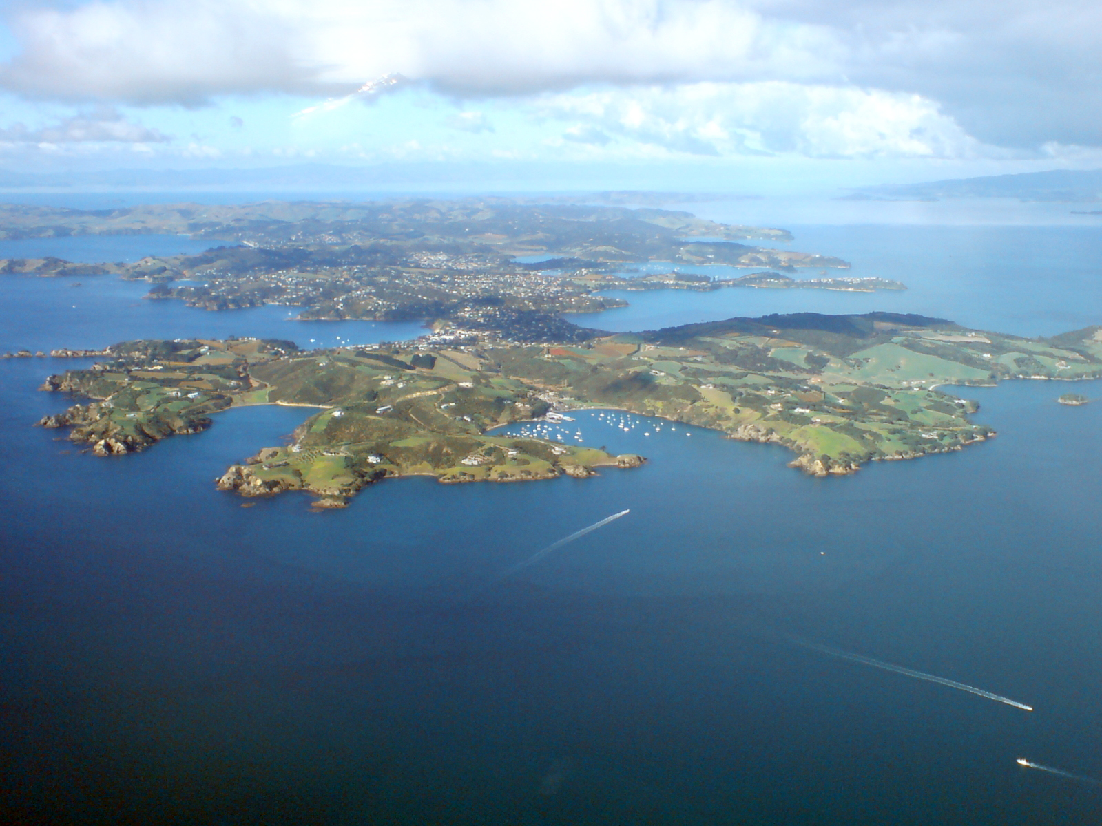
Waiheke Island is the second-largest island (after Great Barrier Island) in the Hauraki Gulf of New Zealand. Its ferry terminal in Matiatia Bay at the western end is from the central-city terminal in Auckland. It is the most populated island in the gulf, with permanent residents, and the third most populous island in New Zealand (behind the two main islands). An additional estimated 3,400 people have second homes or holiday homes on the island. It is more densely populated than the North and South Islands. It is the most accessible island in the gulf, with regular passenger and car-ferry services, a helicopter operator based on the island, and other air links. In November 2015, Lonely Planet rated Waiheke Island the fifth-best region in the world to visit in 2016. Geography Overview The island is off the coast of the North Island. It is in length from west to east, varies in width from , and has a surface area of . The coastline is , including of beaches. The port of ... [...More Info...] [...Related Items...] OR: [Wikipedia] [Google] [Baidu] |
Åmiha
Åmiha is a rural settlement on the southwest coast of Waiheke Island in the Auckland Region of New Zealand. The settlement began when the O'Brien brothers subdivided their farm in 1922, naming it "Omiha Beach Estate". The area is also known as Rocky Bay from the bay to the south. A proposal that the name change to Rocky Bay in 2017 met strong opposition and was rejected. The name Åmiha, with the macron, became official in 2018. Demographics Statistics New Zealand describes Åmiha as a rural settlement, which covers and had an estimated population of as of with a population density of people per km2. Åmiha is part of the larger Waiheke East statistical area. Åmiha had a population of 534 in the 2023 New Zealand census, a decrease of 24 people (â4.3%) since the 2018 census, and an increase of 81 people (17.9%) since the 2013 census. There were 255 males, 279 females and 3 people of other genders in 249 dwellings. 9.0% of people identified as LGBTIQ+. The median ag ... [...More Info...] [...Related Items...] OR: [Wikipedia] [Google] [Baidu] |
Palm Beach, New Zealand
Palm Beach is a settlement on Waiheke Island in northern New Zealand. The eponymous beach is named for phoenix palms at the eastern end, and has safe swimming and white sand. Demographics The statistical area of Oneroa East-Palm Beach, which includes several bays on the north coast of Waiheke, covers and had an estimated population of as of with a population density of people per km2. Oneroa East-Palm Beach had a population of 1,242 in the 2023 New Zealand census, a decrease of 12 people (â1.0%) since the 2018 census, and an increase of 63 people (5.3%) since the 2013 census. There were 624 males, 612 females and 9 people of other genders in 543 dwellings. 6.8% of people identified as LGBTIQ+. The median age was 51.2 years (compared with 38.1 years nationally). There were 147 people (11.8%) aged under 15 years, 138 (11.1%) aged 15 to 29, 606 (48.8%) aged 30 to 64, and 357 (28.7%) aged 65 or older. People could identify as more than one ethnicity. The results were ... [...More Info...] [...Related Items...] OR: [Wikipedia] [Google] [Baidu] |
Matiatia
Matiatia is a location at the western end of Waiheke Island, in New Zealand's Hauraki Gulf. The name is used for both a valley and its surrounding hills, with the valley stretching down to a foreshore and wharf on the gulf. Matiatia is known as "The Gateway to Waiheke Island". The MÄori language MÄori (; endonym: 'the MÄori language', commonly shortened to ) is an Eastern Polynesian languages, Eastern Polynesian language and the language of the MÄori people, the indigenous population of mainland New Zealand. The southernmost membe ... name is shared with a type of beach grass, now rare, which was known to grow at the gateway. References Populated places on Waiheke Island {{Auckland-geo-stub ... [...More Info...] [...Related Items...] OR: [Wikipedia] [Google] [Baidu] |
Auckland City
Auckland City () was a territorial authority area with city status covering the central isthmus of the urban area of Auckland, New Zealand. It was governed by the Auckland City Council from 1989 to 2010, and as a territory within the wider Auckland Region, was also governed by Auckland Regional Council. Auckland City was disestablished as a local authority on 1 November 2010, when Auckland City Council was amalgamated with other councils of the Auckland Region into the new Auckland Council. At the time of its disestablishment, the city had a resident population of around 450,000. The Auckland City included the Auckland CBD â a major financial and commercial centre â the surrounding suburbs, and Hauraki Gulf islands such as Waiheke and Great Barrier Island. Geography The mainland part of Auckland City occupied the Auckland isthmus, also known as the TÄmaki isthmus. The WaitematÄ Harbour, which opens to the Hauraki Gulf, separated North Shore City from the isthmus. T ... [...More Info...] [...Related Items...] OR: [Wikipedia] [Google] [Baidu] |
Hauraki Gulf
The Hauraki Gulf / TÄ«kapa Moana is a coastal feature of the North Island of New Zealand. It has an area of 4000 km2, Zeldisl, J. R. et al. (1995) Salp grazing: effects on phytoplankton abundance, vertical distribution and taxonomic composition in a coastal habitat. Marine Ecology Progress Series, Vol. 126, p 267-283 and lies between, in anticlockwise order, the , the Hauraki Plains, the Coromandel Peninsula, and |
Great Barrier Island
Great Barrier Island () lies in the outer Hauraki Gulf, New Zealand, north-east of central Auckland. With an area of it is the sixth-largest List of islands of New Zealand, island of New Zealand. Its highest point, Mount Hobson, Great Barrier Island, Mount Hobson, is above sea level.Great Barrier Island Aotea page on the DOC website (from the New Zealand Department of Conservation, Department of Conservation. Accessed 2008-06-04.) The local government in New Zealand, local authority is the Auckland Council. The island was initially exploited for its minerals and kauri trees and saw only limited agriculture. In 2013, it was inhabited by 939 people, from Statistics New Zealand. mostly living from ... [...More Info...] [...Related Items...] OR: [Wikipedia] [Google] [Baidu] |
List Of Islands Of New Zealand
New Zealand consists of more than six hundred islands, mainly remnants of Zealandia, a larger land mass now beneath the sea. New Zealand is the List of island countries#UN member states and states with limited recognition, sixth-largest island country, and the third-largest located entirely in the Southern Hemisphere. The following is a list of islands of New Zealand. The two largest islands â where most of the population lives â have names in both English and in the MÄori language. They are the North Island or ''Te Ika-a-MÄui'' and the South Island or ''Te Waipounamu''. Various MÄori iwi sometimes use other names, with some preferring to call the South Island ''Te Waka o Aoraki''. The two islands are separated by the Cook Strait. In general practice, the term ''mainland'' refers to the North Island and South Island. However, the South Island alone is sometimes called "the mainland" â especially by its residents, as a nickname â because it is the larger of the two ma ... [...More Info...] [...Related Items...] OR: [Wikipedia] [Google] [Baidu] |
Hauraki Gulf / TÄ«kapa Moana
The Hauraki Gulf / TÄ«kapa Moana is a coastal feature of the North Island of New Zealand. It has an area of 4000 km2, Zeldisl, J. R. et al. (1995) Salp grazing: effects on phytoplankton abundance, vertical distribution and taxonomic composition in a coastal habitat. Marine Ecology Progress Series, Vol. 126, p 267-283 and lies between, in anticlockwise order, the , the , the , and |
Oneroa, New Zealand
Oneroa is a settlement on Waiheke Island in northern New Zealand. The New Zealand Ministry for Culture and Heritage gives a translation of "long beach" for ''Oneroa''. Whittaker's Music Museum, a specialist music museum, has operated in Oneroa since 1996. Demographics The statistical area of Oneroa West, which includes the suburb and areas west of it, covers and had an estimated population of as of with a population density of people per km2. Oneroa West had a population of 1,344 in the 2023 New Zealand census, a decrease of 90 people (â6.3%) since the 2018 census, and a decrease of 81 people (â5.7%) since the 2013 census. There were 636 males, 702 females and 6 people of other genders in 660 dwellings. 6.9% of people identified as LGBTIQ+. The median age was 53.1 years (compared with 38.1 years nationally). There were 159 people (11.8%) aged under 15 years, 138 (10.3%) aged 15 to 29, 654 (48.7%) aged 30 to 64, and 393 (29.2%) aged 65 or older. People could i ... [...More Info...] [...Related Items...] OR: [Wikipedia] [Google] [Baidu] |
Auckland Region
Auckland () is one of the 16 regions of New Zealand, which takes its name from the eponymous urban areas of New Zealand, urban area. The region encompasses the Auckland, Auckland metropolitan area, smaller towns, rural areas, and the islands of the Hauraki Gulf. Containing percent of the nation's residents, it has by far the largest population and economy of any region of New Zealand, but the second-smallest land area. On 1 November 2010, the Auckland region became a unitary authority administered by the Auckland Council, replacing the previous regional council and seven local councils. In the process, an area in its southeastern corner was transferred to the neighbouring Waikato region. Since then, the Auckland Council has introduced a system of local boards to divide the region for local government. Geography On the mainland, the region extends from the mouth of the Kaipara Harbour in the north across the southern stretches of the Northland Peninsula, through the WaitÄ ... [...More Info...] [...Related Items...] OR: [Wikipedia] [Google] [Baidu] |
Auckland
Auckland ( ; ) is a large metropolitan city in the North Island of New Zealand. It has an urban population of about It is located in the greater Auckland Region, the area governed by Auckland Council, which includes outlying rural areas and the islands of the Hauraki Gulf, and which has a total population of as of It is the List of cities in New Zealand, most populous city of New Zealand and the List of cities in Oceania by population, fifth-largest city in Oceania. The city lies between the Hauraki Gulf to the east, the Hunua Ranges to the south-east, the Manukau Harbour to the south-west, and the WaitÄkere Ranges and smaller ranges to the west and north-west. The surrounding hills are covered in rainforest and the landscape is dotted with 53 volcanic centres that make up the Auckland Volcanic Field. The central part of the urban area occupies a narrow isthmus between the Manukau Harbour on the Tasman Sea and the WaitematÄ Harbour on the Pacific Ocean. Auckland is one of ... [...More Info...] [...Related Items...] OR: [Wikipedia] [Google] [Baidu] |


