|
Visim Nature Reserve
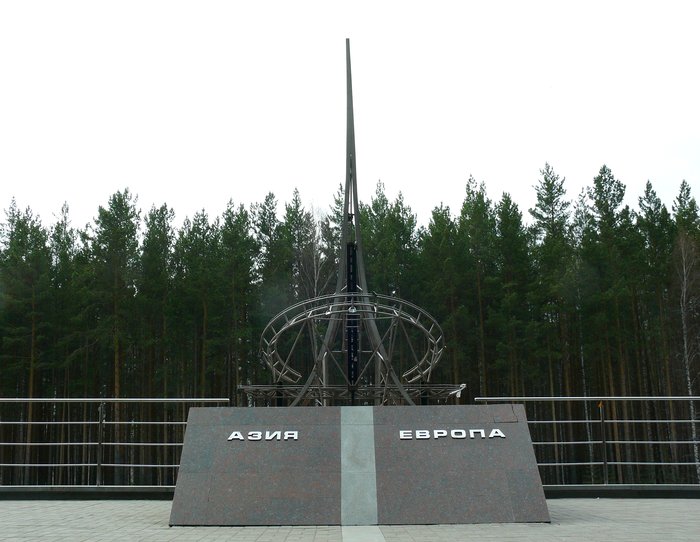
Visim Nature Reserve (russian: Висимский заповедник) (also Visimskiy) is a Russian ' zapovednik' (strict nature reserve) protecting an area of southern taiga in the low Middle Ural Mountains. In 2001, it was named a UNESCO MAB Biosphere Reserve. It is named for the ancient village of Visim, which was home to the Russian writer Dmitry Mamin-Sibiryak, who wrote about rural life in the Urals. Most of the reserve is located on its western slope in the headwaters of the Sulёm River, a right tributary of the Chusovoi River, part of the vast Volga-Kama basin. Part, however is on the eastern slope in the Ob River watershed. The reserve thus straddles the Europe-Asia continental divide: water from the reserve flows into both the Caspian Sea through the Volga River, and the Kara Sea through the Ob River. The reserve is situated in the Kirovgrad District of Sverdlovsk Oblast, about 100 km northwest of Yekaterinburg. Topography The Visim Reserve has a terrain ... [...More Info...] [...Related Items...] OR: [Wikipedia] [Google] [Baidu] |
Sverdlovsk Oblast
Sverdlovsk Oblast ( rus, Свердловская область, Sverdlovskaya oblast) is a federal subject (an oblast) of Russia located in the Ural Federal District. Its administrative center is the city of Yekaterinburg, formerly known as Sverdlovsk. Its population is 4,297,747 (according to the 2010 Census). Geography Most of the oblast is spread over the eastern slopes of the Middle and North Urals and the Western Siberian Plain. Only in the southwest does the oblast stretch onto the western slopes of the Ural Mountains. The highest mountains all rise in the North Urals, Konzhakovsky Kamen at and Denezhkin Kamen at . The Middle Urals is mostly hilly country with no discernible peaks; the mean elevation is closer to above sea level. Principal rivers include the Tavda, the Tura, the Chusovaya, and the Ufa, the latter two being tributaries of the Kama. Sverdlovsk Oblast borders with, clockwise from the west, Perm Krai, the Komi Republic, Khanty–Mansi Auton ... [...More Info...] [...Related Items...] OR: [Wikipedia] [Google] [Baidu] |
Yekaterinburg
Yekaterinburg ( ; rus, Екатеринбург, p=jɪkətʲɪrʲɪnˈburk), alternatively romanized as Ekaterinburg and formerly known as Sverdlovsk ( rus, Свердло́вск, , svʲɪrˈdlofsk, 1924–1991), is a city and the administrative centre of Sverdlovsk Oblast and the Ural Federal District, Russia. The city is located on the Iset River between the Volga-Ural region and Siberia, with a population of roughly 1.5 million residents, up to 2.2 million residents in the urban agglomeration. Yekaterinburg is the fourth-largest city in Russia, the largest city in the Ural Federal District, and one of Russia's main cultural and industrial centres. Yekaterinburg has been dubbed the "Third capital of Russia", as it is ranked third by the size of its economy, culture, transportation and tourism. Yekaterinburg was founded on 18 November 1723 and named after the Russian emperor Peter the Great's wife, who after his death became Catherine I, Yekaterina being the Russian for ... [...More Info...] [...Related Items...] OR: [Wikipedia] [Google] [Baidu] |
Protected Areas Established In 1971
Protection is any measure taken to guard a thing against damage caused by outside forces. Protection can be provided to physical objects, including organisms, to systems, and to intangible things like civil and political rights. Although the mechanisms for providing protection vary widely, the basic meaning of the term remains the same. This is illustrated by an explanation found in a manual on electrical wiring: Some kind of protection is a characteristic of all life, as living things have evolved at least some protective mechanisms to counter damaging environmental phenomena, such as ultraviolet light. Biological membranes such as bark on trees and skin on animals offer protection from various threats, with skin playing a key role in protecting organisms against pathogens and excessive water loss. Additional structures like scales and hair offer further protection from the elements and from predators, with some animals having features such as spines or camouflage serv ... [...More Info...] [...Related Items...] OR: [Wikipedia] [Google] [Baidu] |
1971 Establishments In Russia
* The year 1971 had three partial solar eclipses (Solar eclipse of February 25, 1971, February 25, Solar eclipse of July 22, 1971, July 22 and Solar eclipse of August 20, 1971, August 20) and two total lunar eclipses (February 1971 lunar eclipse, February 10, and August 1971 lunar eclipse, August 6). The world population increased by 2.1% this year, the highest increase in history. Events January * January 2 – 66 people are killed and over 200 injured 1971 Ibrox disaster, during a crush in Glasgow, Scotland. * January 5 – The first ever One Day International cricket match is played between Australia and England at the Melbourne Cricket Ground. * January 8 – Tupamaros kidnap Geoffrey Jackson, British ambassador to Uruguay, in Montevideo, keeping him captive until September. * January 9 – Uruguayan president Jorge Pacheco Areco demands emergency powers for 90 days due to kidnappings, and receives them the next day. * January 12 – The landmark United ... [...More Info...] [...Related Items...] OR: [Wikipedia] [Google] [Baidu] |
Nature Reserves In Russia
Protected areas of Russia, (official Russian title: russian: Особо охраняемые природные территории, literally "Specially Protected Natural Areas"), is governed by the corresponding 1995 law of the Russian Federation. Categories The law establishes the following categories of protected areas: # State nature zapovedniks, including Biosphere reserves (''biosphere zapovedniks'') # National Parks # Nature parks # State nature zakazniks # Natural Monuments # Dendrological parks and botanical gardens # Health recuperation areas and health resorts Other areas Other areas that are protected in Russia include: * UNESCO World Heritage Sites. * city and regional parks. * Ramsar sites — ''wetlands of international significance''. * Russian Cultural heritage monuments. * Historic buildings and gardens — ''e.g.: Imperial Russian palaces and their landscape parks''. Total Land Area On May 21, 2019, the '' Moscow Times'' cited a World Wildlife Fund repo ... [...More Info...] [...Related Items...] OR: [Wikipedia] [Google] [Baidu] |
Zapovednik
Zapovednik (russian: заповедник, plural , from the Russian , 'sacred, prohibited from disturbance, committed o protect committed o heritage; ) is an established term on the territory of the former Soviet Union for a protected area which is kept "forever wild". It is the highest degree of environmental protection for the assigned areas, which are strictly protected and access to the public is restricted. Overview The literal English translation of ''zapovednik'' is "nature sanctuary" (like animal sanctuary); however, in practice, zapovedniks sometimes have to do with the protection of things other than nature and can incorporate historical-cultural, historical–archaeological, and other types of cultural or natural heritage. They also function as important sites for historical research and education and so are comparable to the Sites of Special Scientific Interest as found in the United Kingdom and Hong Kong. The term ''zapovednik'', which refers to the reserve, staff ... [...More Info...] [...Related Items...] OR: [Wikipedia] [Google] [Baidu] |
Old-growth Forest
An old-growth forestalso termed primary forest, virgin forest, late seral forest, primeval forest, or first-growth forestis a forest that has attained great age without significant disturbance, and thereby exhibits unique ecological features, and might be classified as a climax community. The Food and Agriculture Organization of the United Nations defines primary forests as naturally regenerated forests of native tree species where there are no clearly visible indications of human activity and the ecological processes are not significantly disturbed. More than one-third (34 percent) of the world's forests are primary forests. Old-growth features include diverse tree-related structures that provide diverse wildlife habitat that increases the biodiversity of the forested ecosystem. Virgin or first-growth forests are old-growth forests that have never been logged. The concept of diverse tree structure includes multi-layered canopies and canopy gaps, greatly varying tree heig ... [...More Info...] [...Related Items...] OR: [Wikipedia] [Google] [Baidu] |
Köppen Climate Classification
The Köppen climate classification is one of the most widely used climate classification systems. It was first published by German-Russian climatologist Wladimir Köppen (1846–1940) in 1884, with several later modifications by Köppen, notably in 1918 and 1936. Later, the climatologist Rudolf Geiger (1894–1981) introduced some changes to the classification system, which is thus sometimes called the Köppen–Geiger climate classification system. The Köppen climate classification divides climates into five main climate groups, with each group being divided based on seasonal precipitation and temperature patterns. The five main groups are ''A'' (tropical), ''B'' (arid), ''C'' (temperate), ''D'' (continental), and ''E'' (polar). Each group and subgroup is represented by a letter. All climates are assigned a main group (the first letter). All climates except for those in the ''E'' group are assigned a seasonal precipitation subgroup (the second letter). For example, ''Af'' i ... [...More Info...] [...Related Items...] OR: [Wikipedia] [Google] [Baidu] |
Humid Continental Climate
A humid continental climate is a climatic region defined by Russo-German climatologist Wladimir Köppen in 1900, typified by four distinct seasons and large seasonal temperature differences, with warm to hot (and often humid) summers and freezing cold (sometimes severely cold in the northern areas) winters. Precipitation is usually distributed throughout the year but often do have dry seasons. The definition of this climate regarding temperature is as follows: the mean temperature of the coldest month must be below or depending on the isotherm, and there must be at least four months whose mean temperatures are at or above . In addition, the location in question must not be semi-arid or arid. The cooler ''Dfb'', ''Dwb'', and ''Dsb'' subtypes are also known as hemiboreal climates. Humid continental climates are generally found between latitudes 30° N and 60° N, within the central and northeastern portions of North America, Europe, and Asia. They are rare and i ... [...More Info...] [...Related Items...] OR: [Wikipedia] [Google] [Baidu] |
Urals Montane Tundra And Taiga
The Urals montane tundra and taiga ecoregion (WWF ID: PA0610) covers the main ridge of the Ural Mountains (both sides) - a 2,000 km (north-south) by 300 km (west-east) region. The region is on the divide between European and Asian ecoregions, and also the meeting point of tundra and taiga. It is in the Palearctic realm, and mostly in the Boreal forests/taiga ecoregion with a Humid continental climate, cool summer climate. It covers . Location and description The ecoregion is centered on the Ural mountains, a range that reaches heights of . The western edge of the region is the Russian Plain, and the eastern edge is the beginning of the West Siberian Plain. To the north is the Northwest Russian-Novaya Zemlya tundra ecoregion, to the west are the Scandinavian and Russian taiga, Sarmatic mixed forests and East European forest steppe ecoregions, to the east the West Siberian taiga, and to the south the Kazakh steppe. Climate The climate of the Urals is '' Humid c ... [...More Info...] [...Related Items...] OR: [Wikipedia] [Google] [Baidu] |
Kara Sea
The Kara Sea (russian: Ка́рское мо́ре, ''Karskoye more'') is a marginal sea, separated from the Barents Sea to the west by the Kara Strait and Novaya Zemlya, and from the Laptev Sea to the east by the Severnaya Zemlya archipelago. Ultimately the Kara, Barents and Laptev Seas are all extensions of the Arctic Ocean north of Siberia. The Kara Sea's northern limit is marked geographically by a line running from Cape Kohlsaat in Graham Bell Island, Franz Josef Land, to Cape Molotov (Arctic Cape), the northernmost point of Komsomolets Island in Severnaya Zemlya. The Kara Sea is roughly long and wide with an area of around and a mean depth of . Its main ports are Novy Port and Dikson and it is important as a fishing ground although the sea is ice-bound for all but two months of the year. The Kara Sea contains the East-Prinovozemelsky field (an extension of the West Siberian Oil Basin), containing significant undeveloped petroleum and natural gas. In 2014, ... [...More Info...] [...Related Items...] OR: [Wikipedia] [Google] [Baidu] |


