|
Verlaten
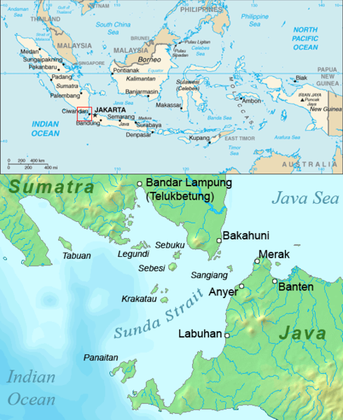
Verlaten Island (Dutch: "Abandoned", "Deserted" or "Forsaken"; modern Indonesian: Sertung) is a volcanic island. It may have been created in the 535 AD eruption of Krakatoa. It is located in the Sunda Strait in Indonesia, between Java and Sumatra. It is part of the Krakatoa Archipelago, above the famous Krakatoa volcano. Other than some minor collapse in the southeast (closest to the main island of Krakatoa), Verlaten suffered little damage in the 1883 eruption. Instead, it grew almost three times in area due to pumice fall, although most of the gain was quickly eroded away. Form Verlaten is a rather low island with a hill in the middle. After the 1883 eruption, Verlaten developed a low spit of land to the northeast with a brackish lake near the end. This lake became a waterfowl Anseriformes is an order of birds also known as waterfowl that comprises about 180 living species of birds in three families: Anhimidae (three species of screamers), Anseranatidae (the magpie g ... [...More Info...] [...Related Items...] OR: [Wikipedia] [Google] [Baidu] |
Krakatoa
Krakatoa (), also transcribed (), is a caldera in the Sunda Strait between the islands of Java and Sumatra in the Indonesian province of Lampung. The caldera is part of a volcanic island group (Krakatoa archipelago) comprising four islands. Two of them are known as Lang Island, Lang and Verlaten Island, Verlaten; another, Rakata, is the only remnant of an island mostly destroyed by an 1883 eruption of Krakatoa, eruption in 1883 which created the caldera. In 1927, a fourth island, Anak Krakatoa, or "Child of Krakatoa", emerged from the caldera formed in 1883. There has been new eruptive activity since the late 20th century, with a large collapse causing 2018 Sunda Strait tsunami, a deadly tsunami in December 2018. Historical significance The most notable eruptions of Krakatoa culminated in a series of massive explosions over 26–27 August 1883, which were among the most violent volcanic events in recorded history. With an estimated Volcanic explosivity index (VEI) of 6, t ... [...More Info...] [...Related Items...] OR: [Wikipedia] [Google] [Baidu] |
Sunda Strait
The Sunda Strait () is the strait between the Indonesian islands of Java island, Java and Sumatra. It connects the Java Sea with the Indian Ocean. Etymology The strait takes its name from the Sunda Kingdom, which ruled the western portion of Java (an area covering the present day West Java, Jakarta, Banten, and some of western Central Java) from 669 to around 1579."Sunda Islands". Concise Dictionary of World Place-Names. John Everett-Heath. Oxford University Press 2005. Oxford Reference Online. Oxford University Press. The name also alludes to the Sundanese people native to West Java and Banten. Geography Extending in a roughly southwest/northeast orientation, with a minimum width of at its northeastern end between Cape Tua on Sumatra and Cape Pujat on Java, the strait is part of the Java Sea. It is essentially triangular in shape, with two large bays on its northern side. It is also very broad and deep at its southwestern end, but as it narrows to the northeast it becomes mu ... [...More Info...] [...Related Items...] OR: [Wikipedia] [Google] [Baidu] |
Indonesia
Indonesia, officially the Republic of Indonesia, is a country in Southeast Asia and Oceania, between the Indian Ocean, Indian and Pacific Ocean, Pacific oceans. Comprising over List of islands of Indonesia, 17,000 islands, including Sumatra, Java, Sulawesi, and parts of Borneo and New Guinea, Indonesia is the world's largest archipelagic state and the List of countries and dependencies by area, 14th-largest country by area, at . With over 280 million people, Indonesia is the world's List of countries and dependencies by population, fourth-most-populous country and the most populous Islam by country, Muslim-majority country. Java, the world's List of islands by population, most populous island, is home to more than half of the country's population. Indonesia operates as a Presidential system, presidential republic with an elected People's Consultative Assembly, legislature and consists of Provinces of Indonesia, 38 provinces, nine of which have Autonomous administrative divisi ... [...More Info...] [...Related Items...] OR: [Wikipedia] [Google] [Baidu] |
Java (island)
Java is one of the Greater Sunda Islands in Indonesia. It is bordered by the Indian Ocean to the south and the Java Sea (a part of Pacific Ocean) to the north. With a population of 156.9 million people (including Madura) in mid 2024, projected to rise to 158 million at mid 2025, Java is the world's List of islands by population, most populous island, home to approximately 55.7% of the Demographics of Indonesia, Indonesian population (only approximately 44.3% of Indonesian population live outside Java). Indonesia's capital city, Jakarta, is on Java's northwestern coast. Many of the best known events in Indonesian history took place on Java. It was the centre of powerful Hindu-Buddhist empires, the Islamic sultanates, and the core of the colonial Dutch East Indies. Java was also the center of the History of Indonesia, Indonesian struggle for independence during the 1930s and 1940s. Java dominates Indonesia politically, economically and culturally. Four of Indonesia's e ... [...More Info...] [...Related Items...] OR: [Wikipedia] [Google] [Baidu] |
Sumatra
Sumatra () is one of the Sunda Islands of western Indonesia. It is the largest island that is fully within Indonesian territory, as well as the list of islands by area, sixth-largest island in the world at 482,286.55 km2 (182,812 mi.2), including adjacent islands such as the Simeulue Island, Simeulue, Nias Island, Nias, Mentawai Islands, Mentawai, Enggano Island, Enggano, Riau Islands, Bangka Belitung and Krakatoa archipelago. Sumatra is an elongated landmass spanning a diagonal northwest–southeast axis. The Indian Ocean borders the northwest, west, and southwest coasts of Sumatra, with the island chain of Simeulue, Nias, Mentawai Islands, Mentawai, and Enggano off the western coast. In the northeast, the narrow Strait of Malacca separates the island from the Malay Peninsula, which is an extension of the Eurasian continent. In the southeast, the narrow Sunda Strait, containing the Krakatoa archipelago, separates Sumatra from Java. The northern tip of Sumatra is near ... [...More Info...] [...Related Items...] OR: [Wikipedia] [Google] [Baidu] |
Volcano
A volcano is commonly defined as a vent or fissure in the crust of a planetary-mass object, such as Earth, that allows hot lava, volcanic ash, and gases to escape from a magma chamber below the surface. On Earth, volcanoes are most often found where tectonic plates are diverging or converging, and because most of Earth's plate boundaries are underwater, most volcanoes are found underwater. For example, a mid-ocean ridge, such as the Mid-Atlantic Ridge, has volcanoes caused by divergent tectonic plates whereas the Pacific Ring of Fire has volcanoes caused by convergent tectonic plates. Volcanoes resulting from divergent tectonic activity are usually non-explosive whereas those resulting from convergent tectonic activity cause violent eruptions."Mid-ocean ridge tectonics, volcanism and geomorphology." Geology 26, no. 455 (2001): 458. https://macdonald.faculty.geol.ucsb.edu/papers/Macdonald%20Mid-Ocean%20Ridge%20Tectonics.pdf Volcanoes can also form where there is str ... [...More Info...] [...Related Items...] OR: [Wikipedia] [Google] [Baidu] |
Pumice
Pumice (), called pumicite in its powdered or dust form, is a volcanic rock that consists of extremely vesicular rough-textured volcanic glass, which may or may not contain crystals. It is typically light-colored. Scoria is another vesicular volcanic rock that differs from pumice in having larger vesicles, thicker vesicle walls, and being dark colored and denser.Jackson, J.A., J. Mehl, and K. Neuendorf (2005) ''Glossary of Geology'' American Geological Institute, Alexandria, Virginia. 800 pp. McPhie, J., M. Doyle, and R. Allen (1993) ''Volcanic Textures A guide to the interpretation of textures in volcanic rocks'' Centre for Ore Deposit and Exploration Studies, University of Tasmania, Hobart, Tasmania..198 pp. Pumice is created when super-heated, highly pressurized rock is rapidly ejected from a volcano. The unusual foamy configuration of pumice happens because of simultaneous rapid cooling and rapid depressurization. The depressurization creates bubbles by lowering the sol ... [...More Info...] [...Related Items...] OR: [Wikipedia] [Google] [Baidu] |
Erosion
Erosion is the action of surface processes (such as Surface runoff, water flow or wind) that removes soil, Rock (geology), rock, or dissolved material from one location on the Earth's crust#Crust, Earth's crust and then sediment transport, transports it to another location where it is deposit (geology), deposited. Erosion is distinct from weathering which involves no movement. Removal of rock or soil as clastic sediment is referred to as ''physical'' or ''mechanical'' erosion; this contrasts with ''chemical'' erosion, where soil or rock material is removed from an area by Solvation, dissolution. Eroded sediment or solutes may be transported just a few millimetres, or for thousands of kilometres. Agents of erosion include rainfall; bedrock wear in rivers; coastal erosion by the sea and Wind wave, waves; glacier, glacial Plucking (glaciation), plucking, Abrasion (geology), abrasion, and scour; areal flooding; Aeolian processes, wind abrasion; groundwater processes; and Mass wastin ... [...More Info...] [...Related Items...] OR: [Wikipedia] [Google] [Baidu] |
Spit (landform)
A spit (cognate with the word for a rotisserie bar) or sandspit is a deposition (geology), deposition shoal, bar or beach landform off coasts or lake shores. It develops in places where re-entrance occurs, such as at a cove's headlands, by the process of longshore drift by longshore currents. The drift occurs due to waves meeting the beach at an oblique angle, moving sediment down the beach in a zigzag pattern. This is complemented by longshore currents, which further sediment transport, transport sediment through the water alongside the beach. These currents are caused by the same waves that cause the drift. Hydrology and geology Where the direction of the shore inland ''re-enters'', or changes direction, for example at a headland, the longshore current spreads out or dissipates. No longer able to carry the full load, much of the sediment is dropped. This is called deposition. This submerged bar of sediment allows longshore drift or littoral drift to continue to transport sed ... [...More Info...] [...Related Items...] OR: [Wikipedia] [Google] [Baidu] |
Brackish Water
Brackish water, sometimes termed brack water, is water occurring in a natural environment that has more salinity than freshwater, but not as much as seawater. It may result from mixing seawater (salt water) and fresh water together, as in estuary, estuaries, or it may occur in brackish Fossil water, fossil aquifers. The word comes from the Middle Dutch root '':wikt:brak#Dutch, brak''. Certain human activities can produce brackish water, in particular civil engineering projects such as dikes and the flooding of coastal marshland to produce brackish water pools for freshwater prawn farming. Brackish water is also the primary waste product of the Osmotic power, salinity gradient power process. Because brackish water is hostile to the growth of most terrestrial plant species, without appropriate management it can be damaging to the environment (see article on shrimp farming, shrimp farms). Technically, brackish water contains between 0.5 and 30 grams of salt per litre—more ofte ... [...More Info...] [...Related Items...] OR: [Wikipedia] [Google] [Baidu] |
Waterfowl
Anseriformes is an order of birds also known as waterfowl that comprises about 180 living species of birds in three families: Anhimidae (three species of screamers), Anseranatidae (the magpie goose), and Anatidae, the largest family, which includes over 170 species of waterfowl, among them the ducks, geese, and swans. Most modern species in the order are highly adapted for an aquatic existence at the water surface. With the exception of screamers, males have penises, a trait that has been lost in the Neoaves, the clade consisting of all other modern birds except the galliformes and paleognaths. Due to their aquatic nature, most species are web-footed. Evolution Anseriformes are one of only two types of modern bird to be confirmed present during the Mesozoic alongside the other dinosaurs, and in fact were among the very few birds to survive their extinction, along with their cousins, the Galliformes. These two groups only occupied two ecological niches during the Mesozoic, ... [...More Info...] [...Related Items...] OR: [Wikipedia] [Google] [Baidu] |


