|
Vandiperiyar
Vandiperiyar, , is a spice village in Idukki district, in the Indian state of Kerala. It is known for tourism, tea and coffee plantations, black pepper and other spice products. It is also known as an educational city and a number of tea factories are situated in the town. The Periyar River flows through the town. Colleges: govt poly technic college. Schools : phss, st Joseph, high range, goodluck educations, govt upper primary, fathima school, govt lower primary, trinity garden. Geography It is located at an altitude of 836 m above MSL. The Periyar River flows through Vandiperiyar. Demographics As of 2011 Census, Periyar village had a population of 22,978 which constitutes 11,397 males and 11,581 females. Periyar village has an area of with 5,749 families residing in it. In Periyar, 9.38% of the population was under 6 years of age. Periyar had an average literacy of 86.38% higher than the national average of 74% and lower than state average of 94%. Location Vandiperiyar ... [...More Info...] [...Related Items...] OR: [Wikipedia] [Google] [Baidu] |
Idukki District
Idukki (ഇടുക്കി; ) is one of the 14 districts in the Indian state of Kerala in the southwest of the country. It is the largest district in Kerala and lies amid the Cardamom Hills of Western Ghats in Kerala. Idukki district contains two municipal towns – Kattappana and Thodupuzha, and five taluks. The district was constituted on 26 January 1972, by taking Peerumade, Udumbanchola, Devikulam taluks of the former High Range division from Kottayam district and the Thodupuzha taluk from Ernakulam district. Its division was previously headquartered at Kottayam city but moved to Kuyilimala near Painavu and Cheruthoni in June 1976. Malayalam and English are the two official administrative languages in the district. Tamil is the second most spoken language in Idukki district after Malayalam. Around 66% of Kerala's power needs come from various hydroelectric power projects in Idukki district. Numerous cash crops and spices are cultivated throughout the dist ... [...More Info...] [...Related Items...] OR: [Wikipedia] [Google] [Baidu] |
National Highway 183 (India)
National Highways 183 (NH 183) is located in India. It connects Kollam High school Jn in Kerala with Dindigul in Tamil Nadu. Starting from Kollam it runs northwards to Thiruvalla and turns east at Kottayam and runs along the northern border of Periyar Wildlife Sanctuary before crossing the border into Tamil Nadu and end near Dindigul, where it joins NH 83(Coimbatore - Nagapattinam). This highway was previously known as NH 220. Check the NH 183 videos. Route Kerala Kollam H.S Jn. → Thevally → Thrikkadavoor → Anchalumoodu → Perinad → Kundara (Elampalloor) → Perayam → Chittumala → East Kallada → Bharanikkavu → Sooranad North → Thamarakulam → Charummoodu → Chunakkara → Mankamkuzhi → Kollakadavu → Kodukulanji → Pennukkara → Chengannur → Kallissery → Kuttoor → Thiruvalla → Changanassery → Chingavanam → Kottayam → Manarkadu → Pampady → Vazhoor → Ponkunnam → Kanjirapalli → Podimattom → Mundaka ... [...More Info...] [...Related Items...] OR: [Wikipedia] [Google] [Baidu] |
Kumily
Kumily, also spelt as Kumaly () is a revenue village and Gram Panchayat in the Idukki district of the state of Kerala. It is a town in Cardamom Hills near Thekkady and Periyar Tiger Reserve and a well frequented tourist destination. Kumily is a border town between Kerala and Tamil Nadu. Demographics Kumily has a population of 35,915 people. As of 2011 Census of India, 2011 Census, Kumily had a population of 30,276 (15,162 male and 15,114 female). Kumily village spreads over an area of with 7,404 families residing in it. The average List of states and union territories of India by sex ratio, sex ratio was a bit lower than the state average (997 vs 1084). 10.3% of the population was under 6 years old. Kumily had an average literacy of 90.5%, which is lower than the state average of 94%; male literacy was 93.6% and female literacy was 87.4%. Transportation Two national highways pass through Kumily town, National Highway 183 (India), National Highway 183 and National Highway 185 ... [...More Info...] [...Related Items...] OR: [Wikipedia] [Google] [Baidu] |
Peerumedu Taluk
Peerumedu taluk is one of the 5 taluks in Idukki district in the Indian state of Kerala. It consists of 10 revenue villages. Constituent Villages The 10 villages of the Peerumedu taluk are: Elappara, Kokkayar, Kumily, Manjumala, Mlappara, Peerumedu, Periyar, Peruvanthanam, Upputhara and Vagamon. Demographics As per 2011 census report, Peerumedu taluk has population of 175,622 of which 87,391 are males and 88,231 are females. The sex-ratio of Peerumedu taluk is around 1010 compared to 1084 which is average of Kerala state. The literacy rate of Peerumade Taluk is 81.33% out of which 84.72% males are literate and 77.98% females are literate. Languages Malayalam is the most widely spoken language in Peerumedu taluk, followed by Tamil Tamil may refer to: People, culture and language * Tamils, an ethno-linguistic group native to India, Sri Lanka, and some other parts of Asia **Sri Lankan Tamils, Tamil people native to Sri Lanka ** Myanmar or Burmese Tamils, Tamil people ... [...More Info...] [...Related Items...] OR: [Wikipedia] [Google] [Baidu] |
States And Territories Of India
India is a federalism, federal union comprising 28 federated state, states and 8 union territory, union territories, for a total of 36 subnational entities. The states and union territories are further subdivided into 800 List of districts in India, districts and smaller administrative divisions of India, administrative divisions by the respective subnational government. The states of India are self-governing administrative divisions, each having a State governments of India, state government. The governing powers of the states are shared between the state government and the Government of India, union government. On the other hand, the union territories are directly governed by the union government. History 1876–1919 The British Raj was a very complex political entity consisting of various imperial divisions and states and territories of varying autonomy. At the time of its establishment in 1876, it was made up of 584 princely state, constituent states and the prov ... [...More Info...] [...Related Items...] OR: [Wikipedia] [Google] [Baidu] |
Thekkady
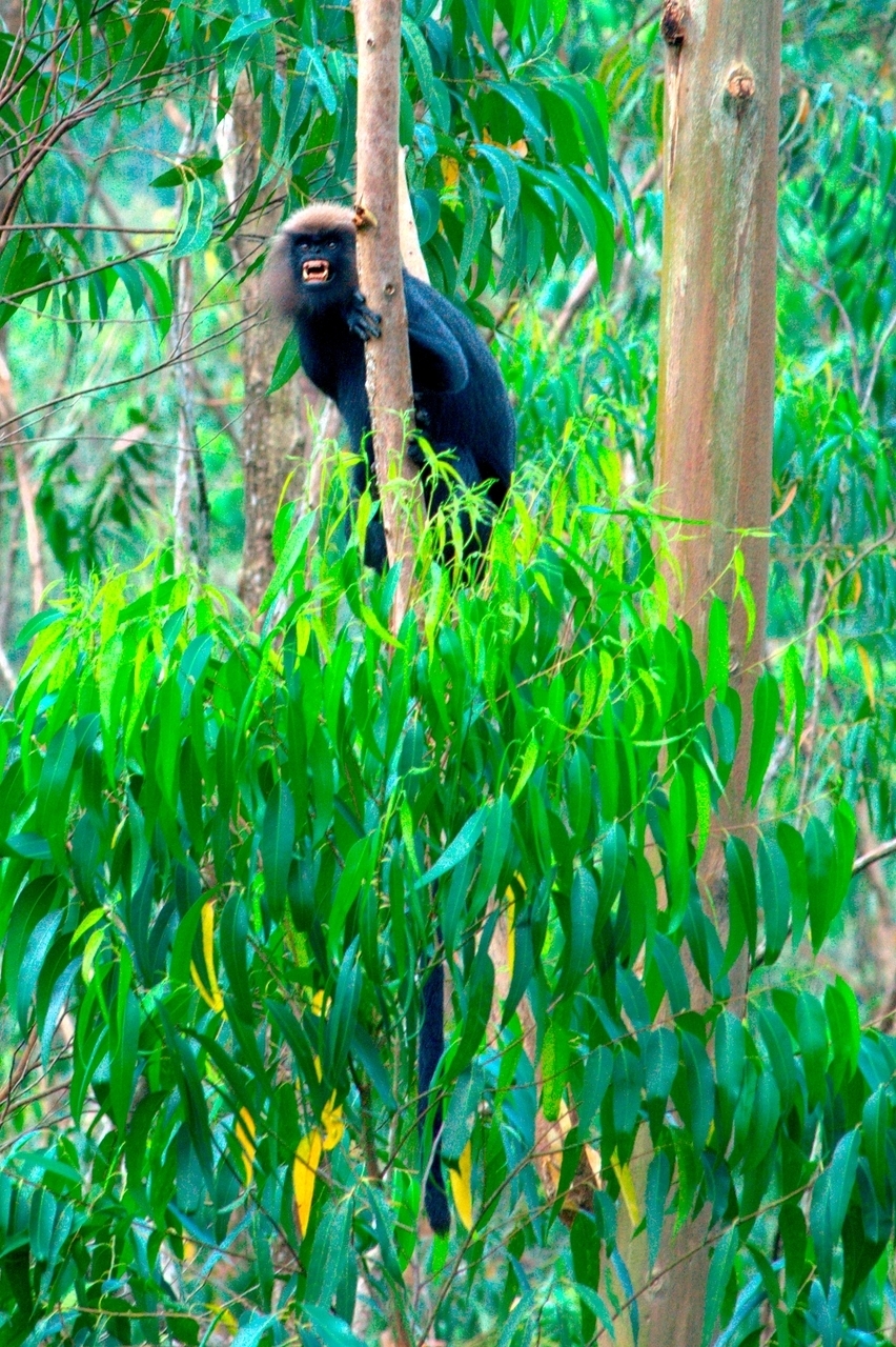
Thekkady () in Idukki district is a town near Periyar National Park, an important tourist attraction in the Kerala States and territories of India, state of India. The name Thekkady is derived from the word "thekku" which means teak and "adi" meaning bottom. Temperatures are lowest in the months of December–January and highest in the months of April–May. Overview Thekkady is situated about from Thiruvananthapuram, Trivandrum, 145 km from Cochin International Airport and 114 km from Kottayam railway station. It is 4 km from Kumily, a plantation town on the Kerala-Tamil Nadu border. The sanctuary is famous for its dense evergreen, semi-evergreen, moist deciduous forests and savanna grass lands. It is home to herds of elephants, sambar deer, sambar, tigers, gaur, lion-tailed macaques and Nilgiri langurs. Due to the density of the forest, sightings of elephants and especially tigers are highly unlikely. The Periyar Wildlife Sanctuary is spread across , of ... [...More Info...] [...Related Items...] OR: [Wikipedia] [Google] [Baidu] |
Kottayam
Kottayam () is a city in the Kottayam district of Kerala, India. It is the district headquarters of the district and is located about north of the state capital Thiruvananthapuram. As per the 2011 Indian census, Kottayam has a population of 489,615 people, and a population density of . The total Kottayam Metropolitan area (the combined area of Kottayam municipality and its adjacent suburbs) has a population of 802,419 people, and a population density of . Kottayam is also referred to as "the City of Letters" as many of the first Malayalam daily newspapers, such as ''Deepika (newspaper), Deepika,'' ''Malayala Manorama,'' and ''Mangalam Publications, Mangalam,'' were started and are headquartered in Kottayam, as are a number of publishing houses. Etymology The royal palace of the Thekkumkur ruler was protected by a fort called ''Thaliyilkotta''. It is believed that the name ''Kottayam'' is derived from a combination of the Malayalam words ''kotta'' which means fort (''Thaliyi ... [...More Info...] [...Related Items...] OR: [Wikipedia] [Google] [Baidu] |
Lion Tailed Macaque In Periyar
The lion (''Panthera leo'') is a large Felidae, cat of the genus ''Panthera'', native to Sub-Saharan Africa and India. It has a muscular, broad-chested body (biology), body; a short, rounded head; round ears; and a dark, hairy tuft at the tip of its tail. It is sexually dimorphic; adult male lions are larger than females and have a prominent mane. It is a social species, forming groups called prides. A lion's pride consists of a few adult males, related females, and cubs. Groups of female lions usually hunt together, preying mostly on medium-sized and large ungulates. The lion is an apex predator, apex and keystone predator. The lion inhabits grasslands, savannahs, and shrublands. It is usually more diurnality, diurnal than other wild cats, but when persecuted, it adapts to being active nocturnality, at night and crepuscular, at twilight. During the Neolithic period, the lion ranged throughout Africa and Eurasia, from Southeast Europe to India, but it has been reduced to fr ... [...More Info...] [...Related Items...] OR: [Wikipedia] [Google] [Baidu] |
Kattappana
Kattappana ( aʈ:ap:ɐna is a municipality in the Idukki district of Kerala, India. It is located 21 km (13.0 mi) southeast of the district headquarters in Painavu and about 140 km (87.0 mi) north of the state capital, Thiruvananthapuram. Kattappana is the second-largest municipality in the district by population, and serves as a major hub for commercial and economic activity for the surrounding region. Kattappana was formed primarily by settlers from Pala, Kanjirapally, Thodupuzha, Muvattupuzha and Kothamangalam in the 1950s, and was given the status of gram panchayat in 1962. The town later attained the Municipality status in 2015. History Historical development The area was mainly settled by people from Pala, Kottayam, Kothamangalam and Thodupuzha. Initially, it was a part of the Udumbanchola Tehsil (Taluk) within the Idukki district. Subsequently, it became a part of the newly formed Idukki Tehsil. Notably, Kattappana emerged as the second m ... [...More Info...] [...Related Items...] OR: [Wikipedia] [Google] [Baidu] |
Postal Index Number
A Postal Index Number (PIN; sometimes redundantly a PIN code) refers to a six-digit code in the Indian postal code system used by India Post. On 15 August 2022, the PIN system celebrated its 50th anniversary. History The PIN system was introduced on 15 August 1972 by Shriram Bhikaji Velankar, an additional secretary in the Government of India, Government of India's Ministry of Communications (India), Ministry of Communications. The system was introduced to simplify the manual sorting and delivery of mail by eliminating confusion over incorrect addresses, similar place names, and different languages used by the public. PIN structure The first digit of a PIN indicates the zone, the second indicates the sub-zone, and the third, combined with the first two, indicates the sorting district within that zone. The final three digits are assigned to individual post offices within the sorting district. Postal zones There are nine postal zones in India, including eight regional zon ... [...More Info...] [...Related Items...] OR: [Wikipedia] [Google] [Baidu] |


