|
Valleuse
In the Pays de Caux, Normandy, France a ''valleuse'' is a depression in the land surface of the plateau which permits access to the sea; it is sometimes translated into English as a "cliff hallow." On the rest of this coast, that access is prevented by the height of the chalk cliffs. There are three (major) sorts: * living valleuse (''valleuse vive''): a natural depression as at Fécamp, Yport and Étretat. * dead valleuse (''valleuse morte''): to obtain the final access to the beach it is necessary to set up a stairway. * perched valleuse (''valleuse perchée''): a simple depression in the plateau surface which do not descend far enough to permit access to the beach. Elsewhere, it might be called a hanging valley though it is formed, not by a glacier but by maritime erosion. There are also three types by stratigraphy: # Simple, # Resistant pedestal, and # Complex. Origins The word is peculiar to the Pays de Caux but the feature is not, though it shows itself particularly well ... [...More Info...] [...Related Items...] OR: [Wikipedia] [Google] [Baidu] |
Pays De Caux
The Pays de Caux (, , literally ''Land of Caux'') is an area in Normandy occupying the greater part of the French '' département'' of Seine Maritime in Normandy. It is a chalk plateau to the north of the Seine Estuary and extending to the cliffs on the English Channel coast; its coastline is known as the Côte d'Albâtre. In the east, it borders on the Pays de Bray where the strata below the chalk show through. Cauchois is a notable dialect of the Norman language. The Pays de Caux is one of the remaining strongholds of the Norman language outside the Cotentin (or Cherbourg) peninsula. The principal communities are Le Havre, Dieppe, Fécamp, Yvetot, and Étretat. Etymology In the Norman language ''caux'' means lime, calcium carbonate. In French, for comparison, the word is ''chaux'' (the French 'ch' being pronounced as an English 'sh'. Example: Caux dialect ''candelle'', English ''candle'', French ''chandelle''). The name of the neighbouring '' Pays de Bray'' c ... [...More Info...] [...Related Items...] OR: [Wikipedia] [Google] [Baidu] |
Geomorphology
Geomorphology () is the scientific study of the origin and evolution of topographic and bathymetric features generated by physical, chemical or biological processes operating at or near Earth's surface. Geomorphologists seek to understand why landscapes look the way they do, to understand landform and terrain history and dynamics and to predict changes through a combination of field observations, physical experiments and numerical modeling. Geomorphologists work within disciplines such as physical geography, geology, geodesy, engineering geology, archaeology, climatology, and geotechnical engineering. This broad base of interests contributes to many research styles and interests within the field. Overview Earth's surface is modified by a combination of surface processes that shape landscapes, and geologic processes that cause tectonic uplift and subsidence, and shape the coastal geography. Surface processes comprise the action of water, wind, ice, wildfire, and lif ... [...More Info...] [...Related Items...] OR: [Wikipedia] [Google] [Baidu] |
Interglacial
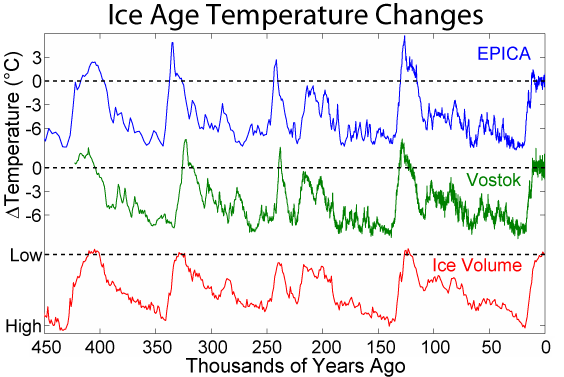
An interglacial period (or alternatively interglacial, interglaciation) is a geological interval of warmer global average temperature lasting thousands of years that separates consecutive glacial periods within an ice age. The current Holocene interglacial began at the end of the Pleistocene, about 11,700 years ago. Pleistocene During the 2.5 million years of the Pleistocene, numerous glacials, or significant advances of continental ice sheets, in North America and Europe, occurred at intervals of approximately 40,000 to 100,000 years. The long glacial periods were separated by more temperate and shorter interglacials. During interglacials, such as the present one, the climate warms and the tundra recedes polewards following the ice sheets. Forests return to areas that once supported tundra vegetation. Interglacials are identified on land or in shallow epicontinental seas by their paleontology. Floral and faunal remains of species pointing to temperate climate and indicating a ... [...More Info...] [...Related Items...] OR: [Wikipedia] [Google] [Baidu] |
English Channel
The English Channel, also known as the Channel, is an arm of the Atlantic Ocean that separates Southern England from northern France. It links to the southern part of the North Sea by the Strait of Dover at its northeastern end. It is the busiest Sea lane, shipping area in the world. It is about long and varies in width from at its widest to at its narrowest in the Strait of Dover."English Channel". ''The Columbia Encyclopedia'', 2004. It is the smallest of the shallow seas around the continental shelf of Europe, covering an area of some . The Channel aided the United Kingdom in becoming a naval superpower, serving as a natural defence against invasions, such as in the Napoleonic Wars and in the World War II, Second World War. The northern, English coast of the Channel is more populous than the southern, French coast. The major languages spoken in this region are English language, English and French language, French. Names Roman historiography, Roman sources as (or , ... [...More Info...] [...Related Items...] OR: [Wikipedia] [Google] [Baidu] |
Permafrost
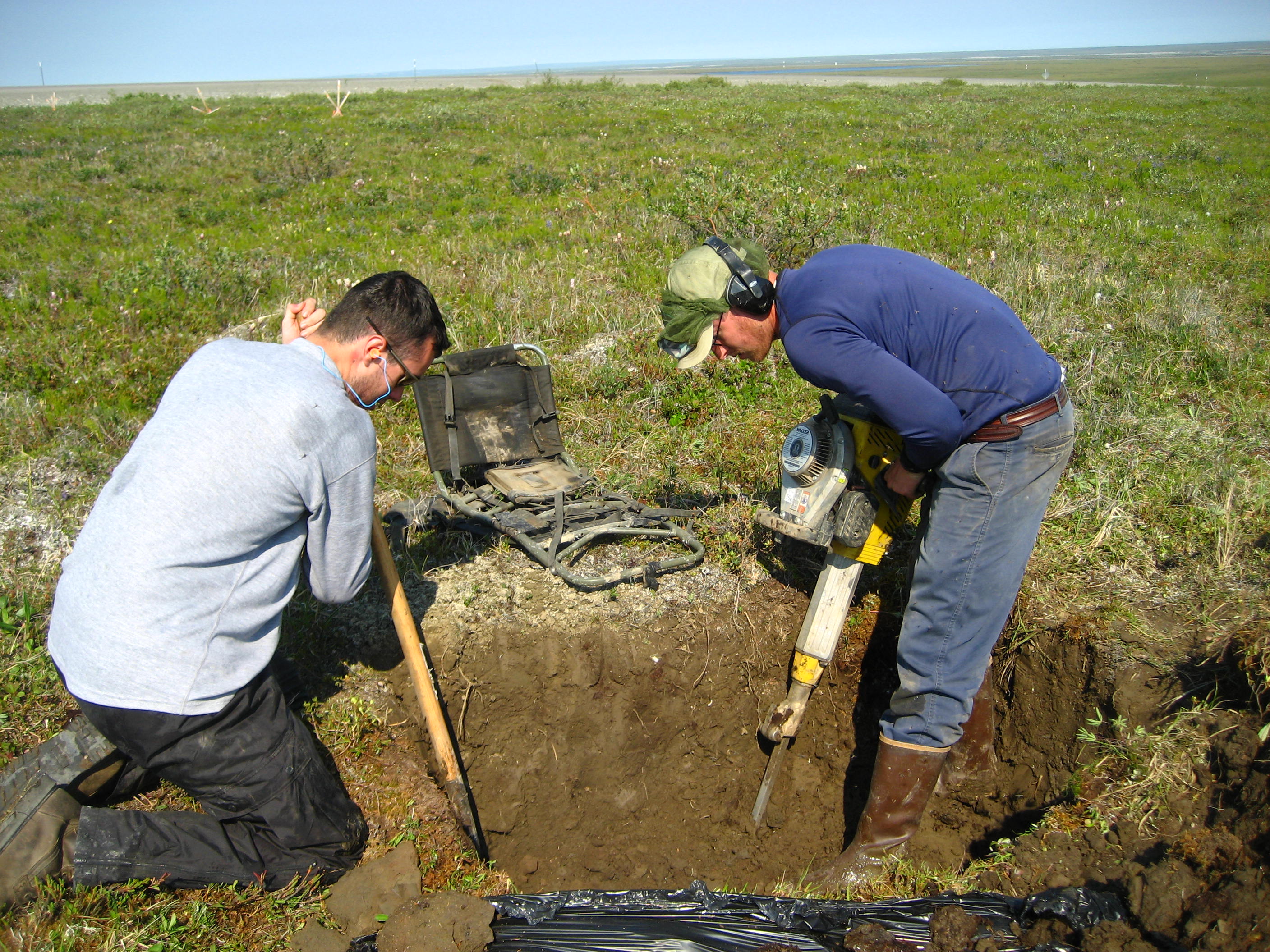
Permafrost () is soil or underwater sediment which continuously remains below for two years or more; the oldest permafrost has been continuously frozen for around 700,000 years. Whilst the shallowest permafrost has a vertical extent of below a meter (3 ft), the deepest is greater than . Similarly, the area of individual permafrost zones may be limited to narrow mountain summits or extend across vast Arctic regions. The ground beneath glaciers and ice sheets is not usually defined as permafrost, so on land, permafrost is generally located beneath a so-called active layer of soil which freezes and thaws depending on the season. Around 15% of the Northern Hemisphere or 11% of the global surface is underlain by permafrost, covering a total area of around . This includes large areas of Alaska, Canada, Greenland, and Siberia. It is also located in high mountain regions, with the Tibetan Plateau being a prominent example. Only a minority of permafrost exists in the Southern Hemi ... [...More Info...] [...Related Items...] OR: [Wikipedia] [Google] [Baidu] |
Ground Water
Groundwater is the water present beneath Earth's surface in rock and soil pore spaces and in the fractures of rock formations. About 30 percent of all readily available fresh water in the world is groundwater. A unit of rock or an unconsolidated deposit is called an ''aquifer'' when it can yield a usable quantity of water. The depth at which soil pore spaces or fractures and voids in rock become completely saturated with water is called the ''water table''. Groundwater is recharged from the surface; it may discharge from the surface naturally at springs and seeps, and can form oases or wetlands. Groundwater is also often withdrawn for agricultural, municipal, and industrial use by constructing and operating extraction wells. The study of the distribution and movement of groundwater is ''hydrogeology'', also called groundwater hydrology. Typically, groundwater is thought of as water flowing through shallow aquifers, but, in the technical sense, it can also contain soil mois ... [...More Info...] [...Related Items...] OR: [Wikipedia] [Google] [Baidu] |
Spring (season)
Spring, also known as springtime, is one of the four temperate seasons, succeeding winter and preceding summer. There are various technical definitions of spring, but local usage of the term varies according to local climate, cultures and customs. When it is spring in the Northern Hemisphere, it is autumn in the Southern Hemisphere and vice versa. At the spring equinox, also called the vernal equinox, Daytime (astronomy), days and nights are approximately twelve hours long, with daytime length increasing and nighttime length decreasing as the season progresses until the summer solstice. The spring equinox is in March in the Northern Hemisphere and in September in the Southern Hemisphere, while the summer solstice is in June in the Northern Hemisphere and in December in the Southern Hemisphere. Spring and "springtime" refer to the season, and also to ideas of rebirth, rejuvenation, renewal, resurrection and regrowth. Subtropical and tropical areas have climates better described ... [...More Info...] [...Related Items...] OR: [Wikipedia] [Google] [Baidu] |
Periglacial
Periglaciation (adjective: "periglacial", referring to places at the edges of glacial areas) describes geomorphic processes that result from seasonal thawing and freezing, very often in areas of permafrost. The meltwater may refreeze in ice wedges and other structures. "Periglacial" originally suggested an environment located on the margin of past glaciers. However, freeze and thaw cycles influence landscapes also outside areas of past glaciation. Therefore, periglacial environments are anywhere when freezing and thawing modify the landscape in a significant manner. History Periglaciation became a distinct subject within the study of geology after Walery Łoziński, a Polish geologist, introduced the term in 1909. Łoziński drew upon the early work of Johan Gunnar Andersson. According to Alfred Jahn, his introduction of his work at the 1910 International Geological Congress held in Stockholm caused significant discussion. In the field trip to Svalbard that followed the congres ... [...More Info...] [...Related Items...] OR: [Wikipedia] [Google] [Baidu] |
Tundra
In physical geography, a tundra () is a type of biome where tree growth is hindered by frigid temperatures and short growing seasons. There are three regions and associated types of tundra: #Arctic, Arctic, Alpine tundra, Alpine, and #Antarctic, Antarctic. Tundra vegetation is composed of dwarf shrubs, Cyperaceae, sedges, Poaceae, grasses, mosses, and lichens. Scattered trees grow in some tundra regions. The ecotone (or ecological boundary region) between the tundra and the forest is known as the tree line or timberline. The tundra soil is rich in nitrogen and phosphorus. The soil also contains large amounts of biomass and decomposed biomass that has been stored as methane and carbon dioxide in the permafrost, making the tundra soil a carbon sink. As global warming heats the ecosystem and causes soil thawing, the permafrost carbon cycle accelerates and releases much of these soil-contained greenhouse gases into the atmosphere, creating Climate change feedback, a feedback cycle t ... [...More Info...] [...Related Items...] OR: [Wikipedia] [Google] [Baidu] |
Ice Cap
In glaciology, an ice cap is a mass of ice that covers less than of land area (usually covering a highland area). Larger ice masses covering more than are termed ice sheets. Description By definition, ice caps are not constrained by topographical features (i.e., they must lie over the top of mountains). By contrast, ice masses of similar size that ''are'' constrained by topographical features are known as ice fields. The ''dome'' of an ice cap is usually centred on the highest point of a massif. Ice flows away from this high point (the ice divide) towards the ice cap's periphery. Ice caps significantly affect the geomorphology of the area they occupy. Plastic moulding, gouging and other glacial erosional features become present upon the glacier's retreat. Many lakes, such as the Great Lakes in North America, as well as numerous valleys have been formed by glacial action over hundreds of thousands of years. The Antarctic and Greenland contain 99% of the ice volume on earth, ... [...More Info...] [...Related Items...] OR: [Wikipedia] [Google] [Baidu] |
Stream
A stream is a continuous body of water, body of surface water Current (stream), flowing within the stream bed, bed and bank (geography), banks of a channel (geography), channel. Depending on its location or certain characteristics, a stream may be referred to by a variety of local or regional names. Long, large streams are usually called rivers, while smaller, less voluminous and more intermittent river, intermittent streams are known, amongst others, as brook, creek, rivulet, rill, run, tributary, feeder, freshet, narrow river, and streamlet. The flow of a stream is controlled by three inputs – surface runoff (from precipitation or meltwater), daylighting (streams), daylighted subterranean river, subterranean water, and surfaced groundwater (Spring (hydrology), spring water). The surface and subterranean water are highly variable between periods of rainfall. Groundwater, on the other hand, has a relatively constant input and is controlled more by long-term patterns of pr ... [...More Info...] [...Related Items...] OR: [Wikipedia] [Google] [Baidu] |


