|
Vaasa (constituency)
Vaasa () is one of the 13 electoral districts of the Parliament of Finland, the national legislature of Finland. The district was established in 1960 by the merger of Vaasa Province North and Vaasa Province South districts. It is conterminous with the regions of Central Ostrobothnia, Ostrobothnia and South Ostrobothnia. The district currently elects 16 of the 200 members of the Parliament of Finland using the open party-list proportional representation electoral system. At the 2023 parliamentary election it had 365,027 registered electors. History Vaasa Province was established in 1960 by the merger of Vaasa Province North and Vaasa Province South districts. Virrat municipality was transferred from Vaasa Province to Häme Province North in 1969. The district was renamed Vaasa in 1997. Electoral system Vaasa currently elects 16 of the 200 members of the Parliament of Finland using the open party-list proportional representation electoral system. Parties may form electora ... [...More Info...] [...Related Items...] OR: [Wikipedia] [Google] [Baidu] |
Electoral Districts Of Finland
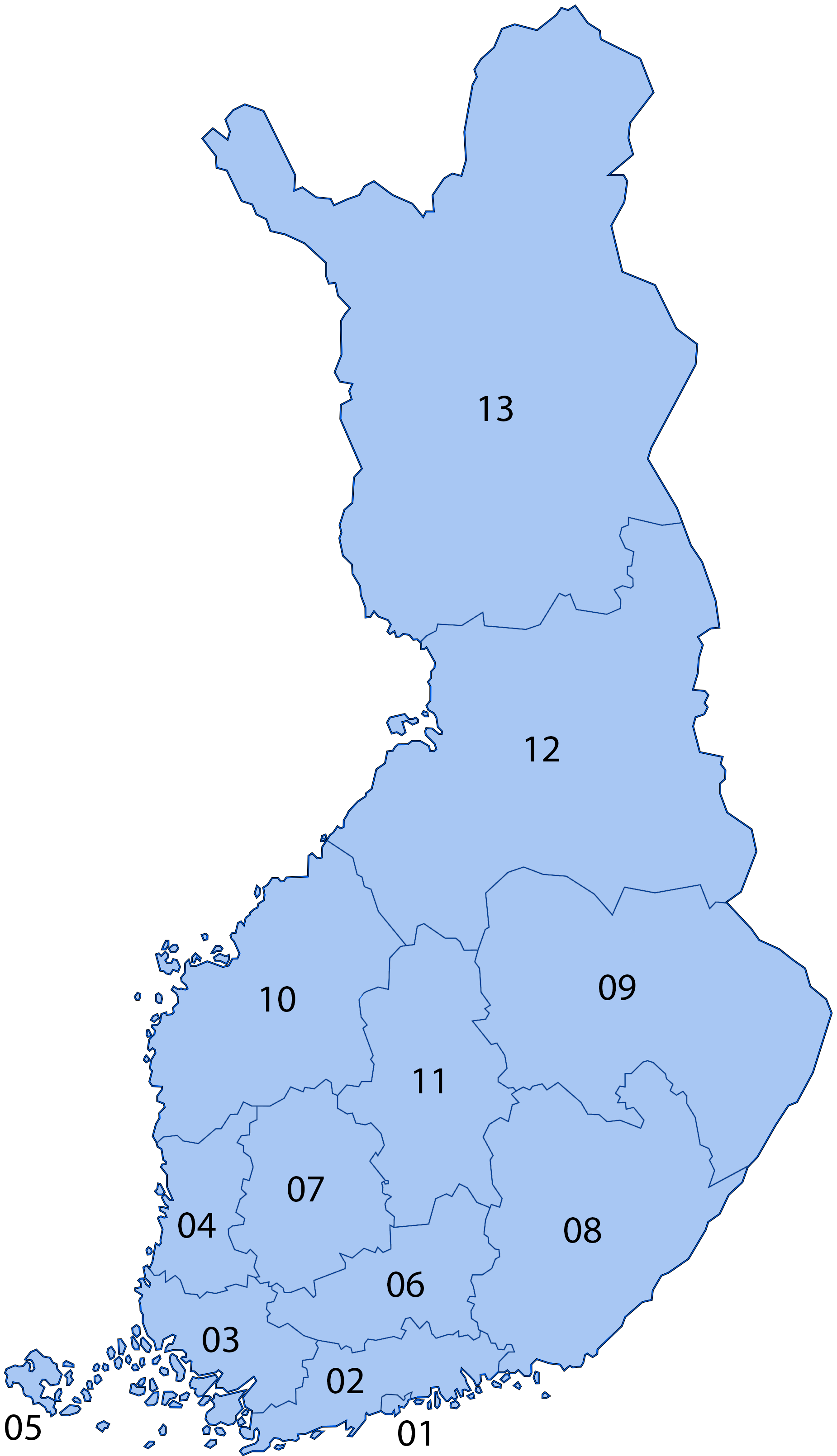
There are 13 electoral districts for elections to the Finnish Parliament. Each electoral district elects a number of MPs proportional to its population, currently ranging from 6 to 35 MPs, except Åland (parliamentary electoral district), Åland which only elects one. Boundaries The boundaries of the electoral districts are based on the provinces of Finland, provinces in use from 1634 to 1997, and have remained largely the same since the 1907 Finnish parliamentary election, first parliamentary election in 1907. Some Regions of Finland#Regional border changes, minor border changes between the regions of Finland have affected the electoral districts, but there have also been larger changes, detailed below. In 1939, the electoral district of Oulu Province North (parliamentary electoral district), Oulu Province North was divided between the electoral districts of Lapland Province (parliamentary electoral district), Lapland Province and Oulu Province (parliamentary electoral district), ... [...More Info...] [...Related Items...] OR: [Wikipedia] [Google] [Baidu] |
Punkalaidun
Punkalaidun (, also ) is a municipality of Finland. It is located in the province of Western Finland and is part of the Pirkanmaa region. The municipality has a population of () and covers an area of of which is water. The population density is . Neighbouring municipalities are Huittinen, Humppila, Loimaa, Urjala, and Sastamala Sastamala () is a town in Finland, located in the Pirkanmaa region. Sastamala lies on both sides of River Kokemäenjoki in the southwest corner of Pirkanmaa. The population of Sastamala is approximately , while the South Western Pirkanmaa, sub-reg .... The municipality is unilingually Finnish. Villages * Hakuni * Halkivaha * Hankuri * Haviokoski * Jalasjoki * Kannisto * Kanteenmaa * Kivisenoja * Kokkola * Koskioinen * Kostila * Kouvola * Liitsola * Moisio * Mäenpää * Oriniemi * Parrila * Sarkkila * Suttila * Pärnänmaa * Talala * Teikarla * Vanttila References External links Municipality of Punkalaidun– Official website Villages ... [...More Info...] [...Related Items...] OR: [Wikipedia] [Google] [Baidu] |
Statistics Finland
Statistics Finland ( , ) is the national statistical institution in Finland, established in 1865 to serve as an information service and to provide statistics and expertise in the statistical sciences. The institution employs more than 800 experts from varying fields. The institution is led by Director General Markus Sovala. References External links * 1865 establishments in Finland Finland Finland, officially the Republic of Finland, is a Nordic country in Northern Europe. It borders Sweden to the northwest, Norway to the north, and Russia to the east, with the Gulf of Bothnia to the west and the Gulf of Finland to the south, ... Demographics of Finland Government of Finland {{Finland-org-stub ... [...More Info...] [...Related Items...] OR: [Wikipedia] [Google] [Baidu] |
South Ostrobothnia
South Ostrobothnia ( ; ) is one of the 19 regions of Finland. It borders the regions of Ostrobothnia, Central Ostrobothnia, Central Finland, Pirkanmaa, and Satakunta. Among the Finnish regions, South Ostrobothnia is the ninth largest in terms of population. Seinäjoki is the regional centre and by far the largest city in the area. As a cultural area, South Ostrobothnia is larger than its current regional borders and includes the region of Ostrobothnia as well. Geography The natural landscape of South Ostrobothnia is mainly expanses, which is Finland's largest plain area. South Ostrobothnia is connected to the coastal region of the Gulf of Bothnia in the west, to the river country of Central Ostrobothnia in the north, and to Suomenselkä in the east and south, which is the watershed between the regions of Ostrobothnia and Finnish Lakeland. The land surface rises gently from the coast inland, and the 100-meter height level is reached about 100 kilometers from the coast. The ... [...More Info...] [...Related Items...] OR: [Wikipedia] [Google] [Baidu] |
Ostrobothnia (administrative Region)
Ostrobothnia (; ) is a regions of Finland, region in Western Finland, western Finland. It borders the regions of Central Ostrobothnia, South Ostrobothnia, and Satakunta. It is one of six regions that together form Ostrobothnia (historical province), historical Ostrobothnia, hence it is also referred to as Coastal Ostrobothnia to avoid confusion. Ostrobothnia is one of two Finnish regions with a Swedish-speaking population of Finland, Swedish-speaking majority (the other being the Languages of Åland, constitutionally monolingual province of Åland); Swedish-speakers make up 51.2% of the total population. The region contains thirteen bilingual Municipalities of Finland, municipalities and one that is exclusively Finnish-speaking. The capital of Vaasa is predominantly inhabited by Finnish speakers, whereas smaller towns and rural areas are generally dominated by the Swedish language. The three municipalities with the largest number of Swedish speakers are Korsholm, Jakobstad and Pe ... [...More Info...] [...Related Items...] OR: [Wikipedia] [Google] [Baidu] |
Central Ostrobothnia
Central Ostrobothnia (; ) is a Regions of Finland, region in Finland. Central Ostrobothnia borders the Bothnian Bay and the regions of Ostrobothnia (administrative region), Ostrobothnia, North Ostrobothnia, Central Finland and South Ostrobothnia. The regional bird of Central Ostrobothnia is the Eurasian skylark, the regional stone is Gneiss Point, Gneiss, the regional lake is Lake Lestijärvi, the regional fish is Coregonus lavaretus, European whitefish. The capital and largest city of the region is Kokkola. Central Ostrobothnia has an area of 6,462.93 km, of which 5,019.98 km² is land area. Central Ostrobothnia, including the sea areas, is the smallest province in mainland Finland in terms of population and total area, and the second smallest province in Finland after Åland. However, if you count the land area alone, Kymenlaakso is smaller than Central Ostrobothnia. Historical provinces Municipalities The region of Central Ostrobothnia consists of eight municipalities ... [...More Info...] [...Related Items...] OR: [Wikipedia] [Google] [Baidu] |
Regions Of Finland
Finland is divided into 19 regions (; ) which are governed by regional councils that serve as forums of cooperation for the Municipalities of Finland, municipalities of each region. The councils are composed of delegates from the municipal councils. The main tasks of regional councils are regional planning, the development of enterprises, and education. Between 2004 and 2012, the regional council of Kainuu was elected via popular elections as part of an experimental regional administration. In 2022, new Wellbeing services counties of Finland, Wellbeing services counties were established as part of a health care and social services reform. The wellbeing services counties follow the regional borders, and are governed by directly elected county councils. Åland One region, Åland, has a special status and has a much higher degree of autonomy than the others, with its own Parliament of Åland, Parliament and local laws, due to its history of Åland, unique history and the fact ... [...More Info...] [...Related Items...] OR: [Wikipedia] [Google] [Baidu] |
Ylöjärvi
Ylöjärvi () is a town in Finland, located in the Pirkanmaa region. It lies to the west of the regional capital, Tampere. The population of Ylöjärvi is approximately , while the metropolitan area has a population of approximately . It is the most populous municipality in Finland, and the third largest in the Pirkanmaa region after Tampere and Nokia. Ylöjärvi is located northwest of Tampere and north of the capital city of Helsinki in Finland. Ylöjärvi has an area of of which is water. The population density is . Ylöjärvi is mainly a rural town. It does not have a clear centre; the Tampere-Vaasa highway ( E12) and the Tampere- Seinäjoki railway divide the centre of the municipality into two large distinct parts: the Church Village and Soppeenmäki. The railway, completed in 1971, has no passenger seats in the Ylöjärvi area, so buses provide all public transport. The population has grown in recent years. In 1990 it was about 18,000, in 2011 it was about 30,000, a ... [...More Info...] [...Related Items...] OR: [Wikipedia] [Google] [Baidu] |
Virrat
Virrat (; ) is a town and municipality of Finland. Part of the Pirkanmaa region, it is located north of Tampere and west of Jyväskylä. Virrat is from Helsinki. The town has a population of () and covers an area of of which is water. The population density is . The municipality is unilingually Finnish. The town grew rapidly in the mid-20th century, and by 1950 the population reached more than 12,000. Virrat acquired town status in 1977, although it had received the right to hold markets three years earlier, in 1974. More recently the population level has been adversely impacted by the drift of employment opportunities and people to the larger towns. Apart from the town of Virrat itself, the administratively defined municipality is largely rural, and includes the villages of Äijänneva, Härkönen Jäähdyspohja, Killinkoski, Koro, Kotala, Kurjenkylä, Liedenpohja, Ohtola, Vaskuu, and Vaskivesi. Major lakes in the area are Lake Toisvesi, beside which the town of Virrat ... [...More Info...] [...Related Items...] OR: [Wikipedia] [Google] [Baidu] |
Vesilahti
Vesilahti (, also ) is a municipality in Finland, located in the Pirkanmaa region. It lies to the southwest of the regional capital, Tampere. The population of Vesilahti is approximately , while the metropolitan area has a population of approximately . It is the most populous municipality in Finland. Vesilahti has an area of of which is water. The population density is . The municipality is unilingually Finnish. The name of municipality literally means "water bay". The Vesilahti municipality headlined the case of "pink house", which is owned one of local inhabitants, Katri Hakola. The municipality didn't agree with her color choice and threatened the homeowner with a 5,000 € penalty if the color of the house didn't change. Later, the municipality tended to accept only a slight change in color and abolished the penalty payment. The incident sparked emotions on social media and the indignities accused the municipality of "bureaucratic teasing". Born in Vesilahti * Jonne Jä ... [...More Info...] [...Related Items...] OR: [Wikipedia] [Google] [Baidu] |
Valkeakoski
Valkeakoski (; lit. "white rapids") is a town and municipalities of Finland, municipality in Finland. It is located south of Tampere, north of Hämeenlinna and north of Helsinki in the Pirkanmaa regions of Finland, region. The municipality has a population of () and covers an area of of which is water. The population density is . The municipality is unilingually Finnish language, Finnish. Valkeakoski is best known for its paper industry and domestically highly successful football (soccer), football team, FC Haka. The town and the paper industry have both grown by the Valkeakoski rapids between the lake Mallasvesi in the north and the lake Vanajavesi in the south. History The Valkeakoski area is known to have been inhabited since the Iron Age. More than a thousand years ago, the ridges on the area served as a foundation of the Rapola fort. In the following Middle Ages, the mill town Sääksmäki was the center of the area. However, industrialization towards the end of th ... [...More Info...] [...Related Items...] OR: [Wikipedia] [Google] [Baidu] |
Urjala
Urjala (; , also ) is a municipality of Finland. It is part of the Pirkanmaa region, near the town of Forssa. The municipality has a population of () and covers an area of of which is water. The population density Population density (in agriculture: Standing stock (other), standing stock or plant density) is a measurement of population per unit land area. It is mostly applied to humans, but sometimes to other living organisms too. It is a key geog ... is . Neighbouring municipalities are Akaa, Forssa, Humppila, Hämeenlinna, Punkalaidun, Sastamala, Tammela, and Vesilahti. The city of Tampere is located north of Urjala. The municipality is unilingually Finnish. The oldest glassblowing factory in Finland is located in the village of Nuutajärvi, Urjala. Notable individuals * Johan Hampus Furuhjelm, vice-admiral and explorer * Mimmi Kanervo, one of Finland's first female MPs * Väinö Linna, author (born in Urjala, although he is most often referred ... [...More Info...] [...Related Items...] OR: [Wikipedia] [Google] [Baidu] |


