|
Umboi
Umboi (also named Rooke or Siassi) is a volcanic island between the mainland of Papua New Guinea and the island of New Britain. It is separated from New Britain by the Dampier Strait and Huon Peninsula, and New Guinea by the Vitiaz Strait. It has an elevation of . Languages are Papuan Kobai; and Austronesian: Mbula, Karanai, and Saveng languages. The Siassi Archipelago lies off the southeast coast of Umboi Island (a total of 18 islands, only seven are inhabited). During the mid-1920s, the population of the Siassi Islands was a little over 700 people. It had more than doubled (to almost 1700 people) by the early 1960s, and then decreased to a little more than 1600 people by the early 1980s. The Siassi support themselves through traditional trade based on a barter system; they are important middlemen who deliver pigs, pots and wooden bowls by sea in their canoes. See also * List of volcanoes in Papua New Guinea * Siassi Rural LLG Siassi Rural LLG is a local-level go ... [...More Info...] [...Related Items...] OR: [Wikipedia] [Google] [Baidu] |
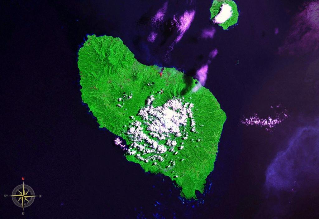
Umboi Island NASA
Umboi (also named Rooke or Siassi) is a volcanic island between the mainland of Papua New Guinea and the island of New Britain. It is separated from New Britain by the Dampier Strait and Huon Peninsula, and New Guinea by the Vitiaz Strait. It has an elevation of . Languages are Papuan Kobai; and Austronesian: Mbula, Karanai, and Saveng languages. The Siassi Archipelago lies off the southeast coast of Umboi Island (a total of 18 islands, only seven are inhabited). During the mid-1920s, the population of the Siassi Islands was a little over 700 people. It had more than doubled (to almost 1700 people) by the early 1960s, and then decreased to a little more than 1600 people by the early 1980s. The Siassi support themselves through traditional trade based on a barter system; they are important middlemen who deliver pigs, pots and wooden bowls by sea in their canoes. See also * List of volcanoes in Papua New Guinea * Siassi Rural LLG Siassi Rural LLG is a local-level governmen ... [...More Info...] [...Related Items...] OR: [Wikipedia] [Google] [Baidu] |
Vitiaz Strait
Vitiaz Strait is a strait between New Britain and the Huon Peninsula, northern New Guinea. The Vitiaz Strait was so named by Nicholai Nicholaievich Mikluho-Maklai to commemorate the Russian corvette '' Vitiaz'' in which he sailed from October 1870 by way of South America and the Pacific Islands reaching Astrolabe Bay in September 1871. Hydrography The 1200 m deep Vitiaz Strait "was a focus of attention by Australian and USA oceanographers on voyages in 1985, 1986, 1988, 1991 and 1992 as part of the Western Equatorial Pacific Ocean Circulation Study, WEPOCS". The New Guinea Coastal Undercurrent transports "high-salinity, low-tritium, high-oxygen, low-nutrient water from the Solomon Sea northwestward along the north coast of Papua New Guinea through the Vitiaz Strait". However, the surface layer current running through the strait, the New Guinea Coastal Current, experiences a seasonal reversal. In boreal summer (northern hemisphere summer) characterized by the south-easterly mo ... [...More Info...] [...Related Items...] OR: [Wikipedia] [Google] [Baidu] |
Dampier Strait (Papua New Guinea)
Dampier Strait in Papua New Guinea separates Umboi Island and New Britain, linking the Bismarck Sea to the north with the deeper Solomon Sea to the south. History The strait is named after the first European to sail through it, British navigator William Dampier in 1700 in . Dampier described his discoveries in his ''A Continuation of a Voyage to New Holland'Ch. 4 New Britain Discoveredin these terms: NEW BRITAIN. The easternmost part of New Guinea lies 40 miles to the westward of this tract of land, and by hydrographers they are made joining together: but here I found an opening and passage between, with many islands; the largest of which lie on the north side of this passage or strait. The channel is very good, between the islands and the land to the eastward. ... As we stood over to the islands we looked out very well to the north, but could see no land that way; by which I was well assured that we were got through, and that this east land does not join to New Guinea; ther ... [...More Info...] [...Related Items...] OR: [Wikipedia] [Google] [Baidu] |
Mbula Language
Mbula (also known as Mangap-Mbula, Mangaaba, Mangaawa, Mangaava, Kaimanga) is an Austronesian language spoken by around 2,500 people on Umboi Island and Sakar Island in the Morobe Province of Papua New Guinea. Its basic word order is subject–verb–object; it has a nominative–accusative case-marking strategy. Name Mbula speakers generally display difficulty expressing a name for their language. Historically it has been referenced as ''Mangap'' or ''Kaimanga'' but ''Kaimanga'' is considered an offensive term along the lines of "unsophisticated bush person". ''Mangap'' is not in known use; however, ''Mangaaba'' is the name given to Mbula speakers by Siassi Islanders. ''Mbula'' is the only name known to have been used by Mbula speakers themselves, though many of them are unfamiliar with this. Language family and origin Mbula is a member of the Oceanic group of Austronesian languages. It was originally proposed as a member of the Siassi language group which is a set of langu ... [...More Info...] [...Related Items...] OR: [Wikipedia] [Google] [Baidu] |
Volcanoes Of Papua New Guinea ...
This is a list of active and extinct volcanoes in Papua New Guinea. New Guinea Admiralty Islands Bougainville D'Entrecasteaux Islands New Britain New Ireland Offshore islands References * Volcanoes of the World External links * {{Global Volcanism Program Papua New Guinea * Volcanoes A volcano is a rupture in the crust of a planetary-mass object, such as Earth, that allows hot lava, volcanic ash, and gases to escape from a magma chamber below the surface. On Earth, volcanoes are most often found where tectonic plates a ... [...More Info...] [...Related Items...] OR: [Wikipedia] [Google] [Baidu] |
New Britain
New Britain ( tpi, Niu Briten) is the largest island in the Bismarck Archipelago, part of the Islands Region of Papua New Guinea. It is separated from New Guinea by a northwest corner of the Solomon Sea (or with an island hop of Umboi the Dampier and Vitiaz Straits) and from New Ireland by St. George's Channel. The main towns of New Britain are Rabaul/ Kokopo and Kimbe. The island is roughly the size of Taiwan. While the island was part of German New Guinea, it was named Neupommern ("New Pomerania"). In common with most of the Bismarcks it was largely formed by volcanic processes, and has active volcanoes including Ulawun (highest volcano nationally), Langila, the Garbuna Group, the Sulu Range, and the volcanoes Tavurvur and Vulcan of the Rabaul caldera. A major eruption of Tavurvur in 1994 destroyed the East New Britain provincial capital of Rabaul. Most of the town still lies under metres of ash, and the capital has been moved to nearby Kokopo. Geography ... [...More Info...] [...Related Items...] OR: [Wikipedia] [Google] [Baidu] |
List Of Volcanoes In Papua New Guinea
This is a list of active and extinct volcanoes in Papua New Guinea. New Guinea Admiralty Islands Bougainville D'Entrecasteaux Islands New Britain New Ireland Offshore islands References * Volcanoes of the World External links * {{Global Volcanism Program Papua New Guinea Papua New Guinea (abbreviated PNG; , ; tpi, Papua Niugini; ho, Papua Niu Gini), officially the Independent State of Papua New Guinea ( tpi, Independen Stet bilong Papua Niugini; ho, Independen Stet bilong Papua Niu Gini), is a country i ... * Volcanoes ... [...More Info...] [...Related Items...] OR: [Wikipedia] [Google] [Baidu] |
Bismarck Archipelago
The Bismarck Archipelago (, ) is a group of islands off the northeastern coast of New Guinea in the western Pacific Ocean and is part of the Islands Region of Papua New Guinea. Its area is about 50,000 square km. History The first inhabitants of the archipelago arrived around 30–40,000 years ago. They may have traveled from New Guinea, by boat across the Bismarck Sea or via a temporary land bridge, created by an uplift in the Earth's Crust (geology), crust. Later arrivals included the Lapita people. The first European to visit these islands was Dutch explorer Willem Schouten in 1616. The islands remained unsettled by western Europeans until they were annexed as part of the German protectorate of German New Guinea in 1884. The area was named in honour of the Chancellor of Germany (German Reich), Chancellor Otto von Bismarck. On 1888 Ritter Island eruption and tsunami, 13 March 1888, a volcano erupted on Ritter Island causing a megatsunami. Almost the entire volcano fell into t ... [...More Info...] [...Related Items...] OR: [Wikipedia] [Google] [Baidu] |
Subduction Volcanoes
Subduction is a geological process in which the oceanic lithosphere is recycled into the Earth's mantle at convergent boundaries. Where the oceanic lithosphere of a tectonic plate converges with the less dense lithosphere of a second plate, the heavier plate dives beneath the second plate and sinks into the mantle. A region where this process occurs is known as a subduction zone, and its surface expression is known as an arc-trench complex. The process of subduction has created most of the Earth's continental crust. Rates of subduction are typically measured in centimeters per year, with the average rate of convergence being approximately two to eight centimeters per year along most plate boundaries. Subduction is possible because the cold oceanic lithosphere is slightly denser than the underlying asthenosphere, the hot, ductile layer in the upper mantle underlying the cold, rigid lithosphere. Once initiated, stable subduction is driven mostly by the negative buoyancy of th ... [...More Info...] [...Related Items...] OR: [Wikipedia] [Google] [Baidu] |
Islands Of Papua New Guinea
An island or isle is a piece of subcontinental land completely surrounded by water. Very small islands such as emergent land features on atolls can be called islets, skerries, cays or keys. An island in a river or a lake island may be called an eyot or ait, and a small island off the coast may be called a holm. Sedimentary islands in the Ganges Delta are called chars. A grouping of geographically or geologically related islands, such as the Philippines, is referred to as an archipelago. There are two main types of islands in the sea: continental islands and oceanic islands. There are also artificial islands (man-made islands). There are about 900,000 official islands in the world. This number consists of all the officially-reported islands of each country. The total number of islands in the world is unknown. There may be hundreds of thousands of tiny islands that are unknown and uncounted. The number of sea islands in the world is estimated to be more than 200,000. The ... [...More Info...] [...Related Items...] OR: [Wikipedia] [Google] [Baidu] |
Siassi Rural LLG
Siassi Rural LLG is a local-level government (LLG) of Morobe Province, Papua New Guinea Papua New Guinea (abbreviated PNG; , ; tpi, Papua Niugini; ho, Papua Niu Gini), officially the Independent State of Papua New Guinea ( tpi, Independen Stet bilong Papua Niugini; ho, Independen Stet bilong Papua Niu Gini), is a country i .... Wards *01. Lokep *02. Masele *03. Aimalu *04. Aupwel *05. Samanai *06. Semo *07. Pandamot *08. Tagop *09. Opai *10. Bunsil *11. Aronai *12. Malai *13. Tuam *14. Mandok *15. Giam *16. Gune *17. Lablab 1 *18. Marile *19. Mabey *20. Movi References * * Local-level governments of Morobe Province {{MorobeProvince-geo-stub ... [...More Info...] [...Related Items...] OR: [Wikipedia] [Google] [Baidu] |


