|
Typhoon Nuri (2014)
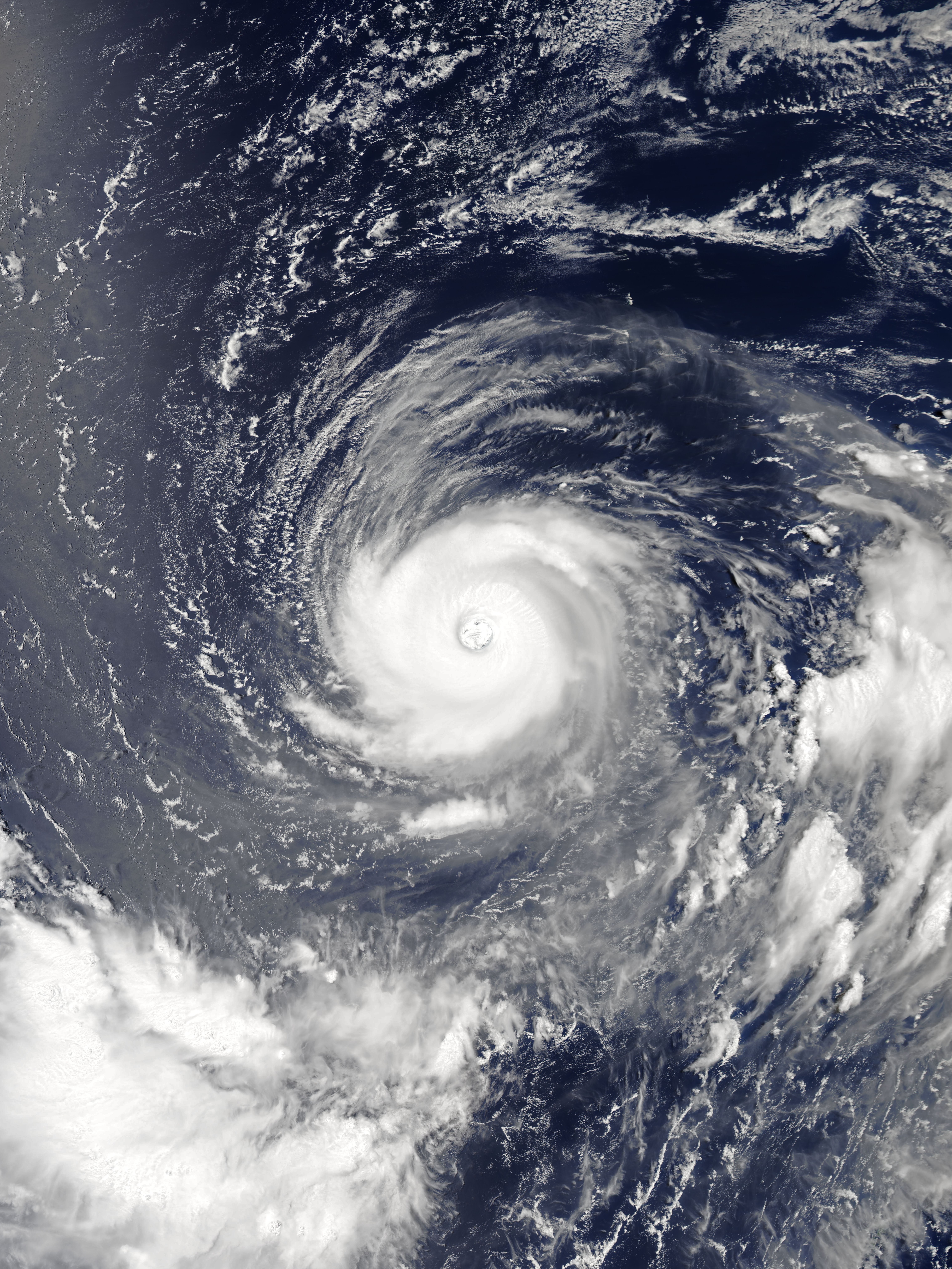
Typhoon Nuri, known in the Philippines as Super Typhoon Paeng, was the third most intense tropical cyclone worldwide in 2014. Nuri developed into a tropical storm and received the name ''Paeng'' from the PAGASA on October 31, before it intensified into a typhoon on the next day. Under excellent conditions, especially the synoptic scale outflow, Nuri underwent rapid deepening and reached its peak intensity on November 2, forming a round eye in a symmetric Central dense overcast (CDO). Having maintained the impressive structure for over one day, the typhoon began to weaken on November 4, with a cloud-filled eye. Because of increasing vertical wind shear from the mid-latitude westerlies, Nuri lost the eye on November 5, and deep convection continued to diminish. The storm accelerated northeastward and completely became extratropical on November 6. However, on November 7, Nuri's circulation split, and the new center absorbed the storm. Meteorological history A low-pressure area f ... [...More Info...] [...Related Items...] OR: [Wikipedia] [Google] [Baidu] |
2014 Pacific Typhoon Season
The 2014 Pacific typhoon season was a slightly below average season in terms of named storms, but featured the highest amount of Category 5 typhoons since 1997 Pacific typhoon season, 1997. This was mainly due to a developing El Niño that favors multiple powerful storms to form in the basin. The season formed twenty-three tropical storms (including one that crossed over from the Eastern/Central Pacific), eleven typhoons, eight super typhoons, and seven Category 5 typhoons. The season's peak months August and September saw minimal activity caused by an unusually strong and a persistent suppressing phase of the Madden–Julian oscillation (MJO). The season ran throughout 2014, though most tropical cyclones typically tropical cyclogenesis, develop between June and October. The season began with the development of Tropical Storm Lingling (2014), Tropical Storm Lingling on January 18, and ended after Tropical Storm Jangmi (2014), Tropical Storm Jangmi which di ... [...More Info...] [...Related Items...] OR: [Wikipedia] [Google] [Baidu] |
Outflow (meteorology)
Outflow, in meteorology, is air that flows outwards from a storm system. It is associated with ridging, or anticyclone, anticyclonic flow. In the low levels of the troposphere, outflow radiates from thunderstorms in the form of a wedge of rain-cooled air, which is visible as a thin rope-like cloud on weather satellite imagery or a fine line on weather radar imagery. For observers on the ground, a thunderstorm outflow boundary often approaches in otherwise clear skies as a low, thick cloud that brings with it a gust front. Low-level outflow boundaries can disrupt the center of small tropical cyclones. However, outflow aloft is essential for the strengthening of a tropical cyclone. If this outflow is restricted or undercut, the tropical cyclone weakens. If two tropical cyclones are close, the upper-level outflow from the upwind system can limit the development of the other system. Thunderstorms For thunderstorms, outflow tends to indicate the development of a system. Large quan ... [...More Info...] [...Related Items...] OR: [Wikipedia] [Google] [Baidu] |
Typhoon Hagupit (2014)
Typhoon Hagupit, (, ) known in the Philippines as Super Typhoon Ruby, was the second most intense tropical cyclone in 2014. Hagupit particularly impacted the Philippines in early December while gradually weakening, killing 18 people and causing $114 million (2014 USD) of damage in the country. Prior to making landfall, Hagupit was considered the worst threat to the Philippines in 2014, but it was significantly smaller than 2013's Typhoon Haiyan. Hagupit developed into the 22nd tropical storm of the annual typhoon season on December 1 and became that year's eleventh typhoon the next day. Under a favorable environment, the typhoon underwent rapid deepening and reached peak intensity northwest of Palau on December 4, with a clear eye. Hagupit slightly weakened but restrengthened on December 5, but subsequently started to weaken again, due to subsidence associated with an upper-level trough. The typhoon made its first landfall over the province of Eastern Samar in the Philippine ... [...More Info...] [...Related Items...] OR: [Wikipedia] [Google] [Baidu] |
Typhoon Vongfong (2014)
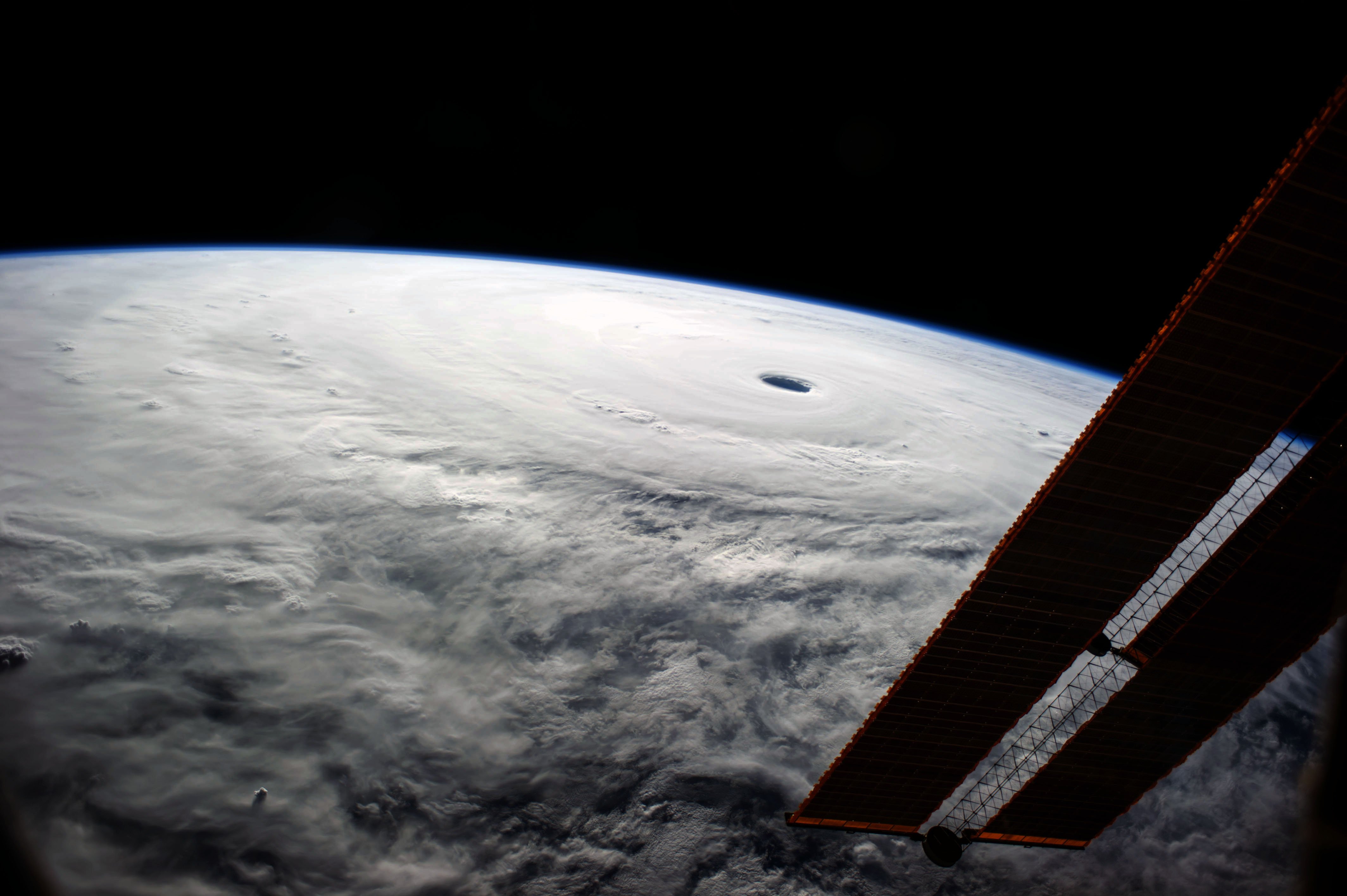
Typhoon Vongfong, known in the Philippines as Super Typhoon Ompong, was the most intense tropical cyclone Tropical cyclones in 2014, worldwide in 2014, and struck Japan as a large tropical system. It also indirectly affected the Philippines and Taiwan. Vongfong was the nineteenth named storm and the ninth typhoon of the 2014 Pacific typhoon season. Estimates assess damage from Vongfong to have been over United States dollar, US$160 million, mainly for striking mainland Japan. At least 9 people were killed along the path of the typhoon in those countries. Both the Japan Meteorological Agency, JMA and the Joint Typhoon Warning Center, JTWC upgraded Vongfong to a tropical storm on October 3. Under low vertical wind shear and excellent Outflow (meteorology), outflow, Vongfong intensified into a typhoon east of Guam on October 5. Afterwards, Subsidence (atmosphere), subsidence and moderate to strong vertical wind shear caused the typhoon to struggle to intensify. On October 7, the PAG ... [...More Info...] [...Related Items...] OR: [Wikipedia] [Google] [Baidu] |
Okinotorishima
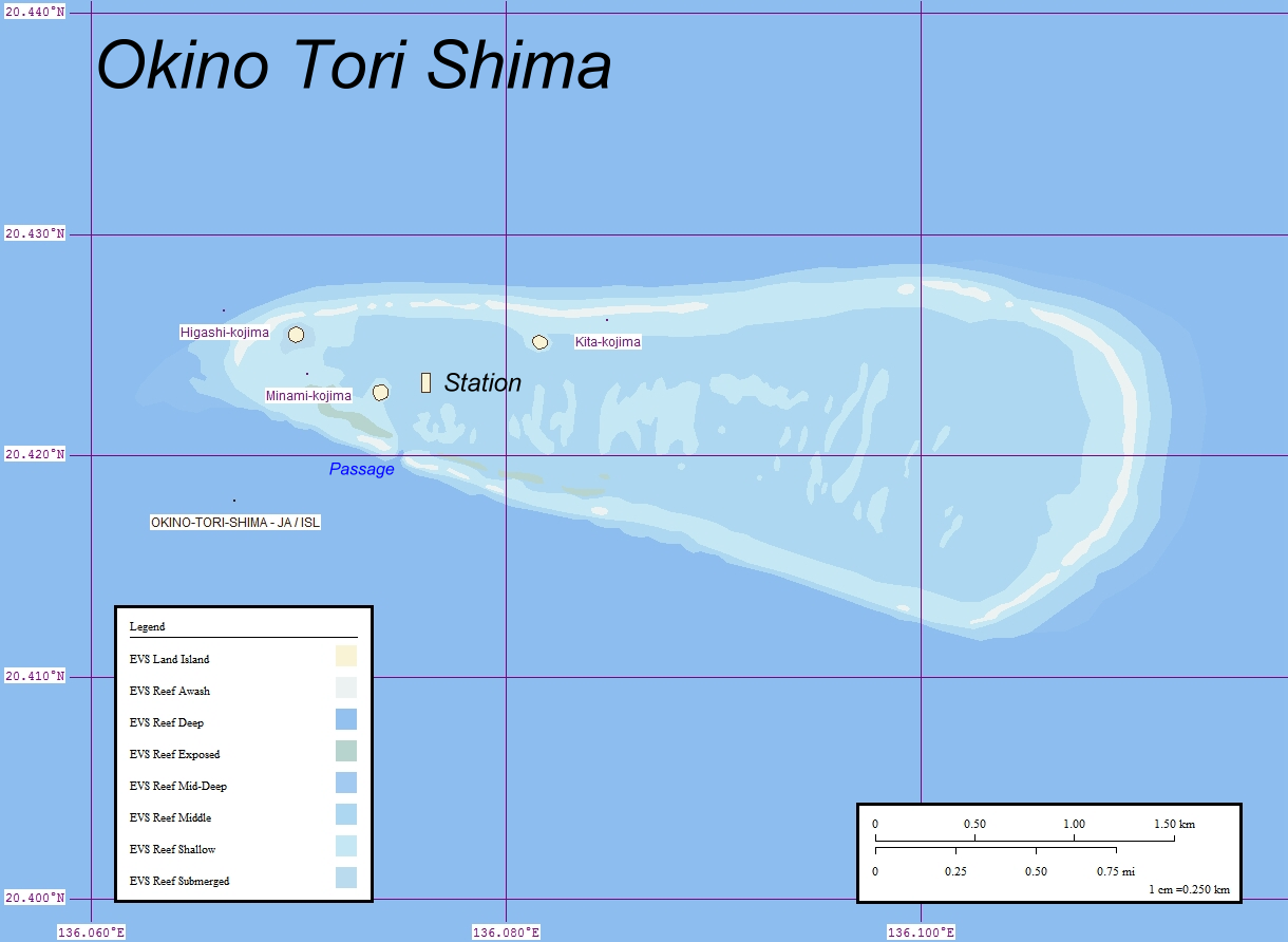
, or Parece Vela, is a coral reef, geologically an atoll, with two rocks enlarged with tetrapod-cement structures. It is administered by Japan with a total shoal area of and land area . Its dry land area is mostly made up by three concrete encasings and there is a stilt platform in the lagoon housing a research station. There is a third completely artificial tetrapod-cement islet. Okinotorishima is located on the Palau–Kyushu Ridge in the Philippine Sea, southeast of Okidaitōjima and west-southwest of South Iwo Jima in the Bonin Islands or south of Tokyo, Japan. Okinotorishima is the southernmost part of Japan and the only Japanese territory south of the Tropic of Cancer. Japan argues that Okinotorishima is significant enough for it to claim a exclusive economic zone (EEZ) around it, but China, South Korea, and Taiwan dispute the Japanese EEZ, saying that the atoll does not meet the definition of an island under the United Nations Convention on the Law of the Sea. ... [...More Info...] [...Related Items...] OR: [Wikipedia] [Google] [Baidu] |
InHg
Inch of mercury (inHg, ″Hg, or in) is a non- SI unit of measurement for pressure. It is used for barometric pressure in weather reports, refrigeration and aviation in the United States. It is the pressure exerted by a column of mercury in height at the standard acceleration of gravity. Conversion to metric units depends on the density of mercury, and hence its temperature; typical conversion factors are: In older literature, an "inch of mercury" is based on the height of a column of mercury at .Barry N. Taylor, ''Guide for the Use of the International System of Units (SI),'' 1995, NIST Special Publication 811, Appendix /ref> :1 inHg60 °F = In Imperial units: 1 inHg60 °F = 0.489 771 Pounds per square inch, psi, or 2.041 771 inHg60 °F = 1 psi. Applications Aircraft and automobiles Aircraft altimeters measure the relative pressure difference between the lower ambient pressure at altitude and a calibrated reading on the ground. ... [...More Info...] [...Related Items...] OR: [Wikipedia] [Google] [Baidu] |
Pascal (unit)
The pascal (symbol: Pa) is the unit of pressure in the International System of Units (SI). It is also used to quantify internal pressure, stress, Young's modulus, and ultimate tensile strength. The unit, named after Blaise Pascal, is an SI coherent derived unit defined as one newton per square metre (N/m2). It is also equivalent to 10 barye (10 Ba) in the CGS system. Common multiple units of the pascal are the hectopascal (1 hPa = 100 Pa), which is equal to one millibar, and the kilopascal (1 kPa = 1000 Pa), which is equal to one centibar. The unit of measurement called '' standard atmosphere (atm)'' is defined as . Meteorological observations typically report atmospheric pressure in hectopascals per the recommendation of the World Meteorological Organization, thus a standard atmosphere (atm) or typical sea-level air pressure is about 1013 hPa. Reports in the United States typically use inches of mercury or millibars (hectopascals). In Cana ... [...More Info...] [...Related Items...] OR: [Wikipedia] [Google] [Baidu] |
Anticyclone
A high-pressure area, high, or anticyclone, is an area near the surface of a planet where the atmospheric pressure is greater than the pressure in the surrounding regions. Highs are middle-scale meteorological features that result from interplays between the relatively larger-scale dynamics of an entire planet's atmospheric circulation. The strongest high-pressure areas result from masses of cold air which spread out from polar regions into cool neighboring regions. These highs weaken once they extend out over warmer bodies of water. Weaker—but more frequently occurring—are high-pressure areas caused by atmospheric subsidence: Air becomes cool enough to precipitate out its water vapor, and large masses of cooler, drier air descend from above. Within high-pressure areas, winds flow from where the pressure is highest, at the center of the area, towards the periphery where the pressure is lower. However, the direction is not straight from the center outwards, but curved du ... [...More Info...] [...Related Items...] OR: [Wikipedia] [Google] [Baidu] |
Mesoscale Meteorology
Mesoscale meteorology is the study of weather systems and processes at horizontal scales of approximately to several hundred kilometres. It is smaller than synoptic scale meteorology, synoptic-scale systems (1,000 km or larger) but larger than Microscale meteorology, microscale (less than 1 km). At the small end, it includes storm-scale phenomena (the size of an individual thunderstorm). Examples of mesoscale weather systems are sea breezes, squall lines, and mesoscale convective complexes. Vertical velocity often equals or exceeds horizontal velocities in mesoscale meteorological systems due to nonhydrostatic processes such as buoyant acceleration of a rising thermal or acceleration through a narrow mountain pass. Classification The History of weather forecasting, earliest networks of weather observations in the late 1800s and early 1900s could detect the movement and evolution of larger, synoptic scale, synoptic-scale systems like high pressure area, high and low-pressure area ... [...More Info...] [...Related Items...] OR: [Wikipedia] [Google] [Baidu] |
Convection
Convection is single or Multiphase flow, multiphase fluid flow that occurs Spontaneous process, spontaneously through the combined effects of material property heterogeneity and body forces on a fluid, most commonly density and gravity (see buoyancy). When the cause of the convection is unspecified, convection due to the effects of thermal expansion and buoyancy can be assumed. Convection may also take place in soft solids or mixtures where particles can flow. Convective flow may be Transient state, transient (such as when a Multiphasic liquid, multiphase mixture of oil and water separates) or steady state (see convection cell). The convection may be due to Gravity, gravitational, Electromagnetism, electromagnetic or Fictitious force, fictitious body forces. Convection (heat transfer), Heat transfer by natural convection plays a role in the structure of Earth's atmosphere, its oceans, and its Earth's mantle, mantle. Discrete convective cells in the atmosphere can be identified by ... [...More Info...] [...Related Items...] OR: [Wikipedia] [Google] [Baidu] |
Microwave
Microwave is a form of electromagnetic radiation with wavelengths shorter than other radio waves but longer than infrared waves. Its wavelength ranges from about one meter to one millimeter, corresponding to frequency, frequencies between 300 MHz and 300 GHz, broadly construed. A more common definition in radio-frequency engineering is the range between 1 and 100 GHz (wavelengths between 30 cm and 3 mm), or between 1 and 3000 GHz (30 cm and 0.1 mm). In all cases, microwaves include the entire super high frequency, super high frequency (SHF) band (3 to 30 GHz, or 10 to 1 cm) at minimum. The boundaries between far infrared, terahertz radiation, microwaves, and ultra-high-frequency (UHF) are fairly arbitrary and differ between different fields of study. The prefix ' in ''microwave'' indicates that microwaves are small (having shorter wavelengths), compared to the radio waves used in prior radio technology. Frequencies in the micr ... [...More Info...] [...Related Items...] OR: [Wikipedia] [Google] [Baidu] |
Typhoon
A typhoon is a tropical cyclone that develops between 180° and 100°E in the Northern Hemisphere and which produces sustained hurricane-force winds of at least . This region is referred to as the Northwestern Pacific Basin, accounting for almost one third of the world's tropical cyclones. For organizational purposes, the northern Pacific Ocean is divided into three regions: the eastern (North America to 140°W), central (140°W to 180°), and western (180° to 100°E). The Regional Specialized Meteorological Center (RSMC) for tropical cyclone forecasts is in Japan, with other tropical cyclone warning centres for the northwest Pacific in Hawaii (the Joint Typhoon Warning Center), the Philippines, and Hong Kong. Although the RSMC names each system, the main name list itself is coordinated among 18 countries that have territories threatened by typhoons each year. Within most of the northwestern Pacific, there are no official typhoon seasons as tropical cyclones form througho ... [...More Info...] [...Related Items...] OR: [Wikipedia] [Google] [Baidu] |


