|
Typhoon Lekima (2019)
Typhoon Lekima, known in the Philippines as Typhoon Hanna, was the fourth costliest typhoon in Chinese history. The ninth Tropical cyclone naming, named storm of the 2019 Pacific typhoon season, Lekima originated from a tropical depression that formed east of the Philippines on 30 July. It gradually organized, became a tropical storm, and was named on 4 August. Lekima intensified under favorable environmental conditions and peaked as a Category 4–equivalent Super typhoon. However, an eyewall replacement cycle caused the typhoon to weaken before it made landfall in Zhejiang early on 10 August, as a Category 2–equivalent typhoon. Lekima weakened subsequently while moving across Eastern China, and made its second landfall in Shandong on 11 August. Lekima's precursor enhanced the southwestern monsoon in the Philippines, which brought heavy rain to the country. The rains caused three boats to sink and 31 people died in this accident. Lekima brought catastrophic damage in mainland Ch ... [...More Info...] [...Related Items...] OR: [Wikipedia] [Google] [Baidu] |
Ryukyu Islands
The , also known as the or the , are a chain of Japanese islands that stretch southwest from Kyushu to Geography of Taiwan, Taiwan: the Ryukyu Islands are divided into the Satsunan Islands (Ōsumi Islands, Ōsumi, Tokara Islands, Tokara and Amami Islands, Amami) and Okinawa Prefecture (Daitō Islands, Daitō, Miyako Islands, Miyako, Yaeyama Islands, Yaeyama, Senkaku Islands, Senkaku, Okinawa Islands, Okinawa, Sakishima Islands (further divided into the Miyako Islands, Miyako and Yaeyama Islands), and Yonaguni as the westernmost). The larger ones are mostly volcanic islands and the smaller mostly coral island, coral. The largest is Okinawa Island. The climate of the islands ranges from humid subtropical climate (Köppen climate classification ''Cfa'') in the north to tropical rainforest climate (Köppen climate classification ''Af'') in the south. Precipitation is very high and is affected by the rainy season and typhoons. Except the outlying Daitō Islands, the island chain ha ... [...More Info...] [...Related Items...] OR: [Wikipedia] [Google] [Baidu] |
Philippine Sea
The Philippine Sea is a List of seas#Marginal seas by ocean, marginal sea of the Pacific Ocean, Western Pacific Ocean east of the list of islands of the Philippines, Philippine Archipelago (hence the name) and the List of seas#Largest seas by area, largest sea in the world, occupying an estimated surface area of . The Philippine Sea Plate forms the floor of the sea. Its western border is the first island chain to the west, comprising the Ryukyu Islands in the northwest and Taiwan in the west. Its southwestern border comprises the Philippines, Philippine islands of Luzon, Catanduanes, Samar, Leyte, and Mindanao. Its northern border comprises the Japanese islands of Honshu, Shikoku and Kyūshū. Its eastern border is the second island chain to the east, comprising the Bonin Islands and Iwo Jima in the northeast, the Mariana Islands (including Guam, Saipan, and Tinian) in the due east, and Halmahera, Palau, Yap and Ulithi (of the Caroline Islands) in the southeast. Its southern ... [...More Info...] [...Related Items...] OR: [Wikipedia] [Google] [Baidu] |
Miyako-jima
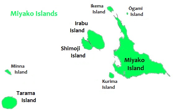
is the largest and the most populous island among the Miyako Islands of Okinawa Prefecture, Japan. Miyako Island is administered as part of the City of Miyako Island, which includes not only Miyako Island, but also five other islands. Geography Miyako Island lies approximately southwest of Okinawa Island. With an area of , Miyako is the fourth-largest island in Okinawa Prefecture. The island is triangular in shape and is composed of limestone. Miyako Island is subject to drought and is frequently struck by typhoons. Miyako Island is well known for its beauty, particularly the , a nationally designated Place of Scenic Beauty at the southeasternmost point of Miyako Island. It is considered by many as one of the most beautiful spots in Japan. Other notable locations include Yonaha Maehama beach, Sunayama beach, Painagama Beach and the sights on Irabu-jima. There are three islands nearby which are connected by bridges to Miyako Island, Irabujima (as of early 2015), , and . ... [...More Info...] [...Related Items...] OR: [Wikipedia] [Google] [Baidu] |
Maximum Sustained Wind
The maximum sustained wind associated with a tropical cyclone is a common indicator of the intensity of the storm. Within a mature tropical cyclone, it is found within the eyewall at a certain distance from the center, known as the radius of maximum wind, or RMW. Unlike gusts, the value of these winds are determined via their sampling and averaging the sampled results over a period of time. Wind measuring has been standardized globally to reflect the winds at above mean sea level, and the maximum sustained wind represents the highest average wind over either a one-minute (US) or ten-minute time span (see the definition, below), anywhere within the tropical cyclone. Surface winds are highly variable due to friction between the atmosphere and the Earth's surface, as well as near hills and mountains over land. Over the ocean, satellite imagery is often used to estimate the maximum sustained winds within a tropical cyclone. Land, ship, aircraft reconnaissance observations, an ... [...More Info...] [...Related Items...] OR: [Wikipedia] [Google] [Baidu] |
Annular Tropical Cyclone
An annular tropical cyclone is a tropical cyclone that features a normal to large, symmetric eye surrounded by a thick and uniform ring of intense convection, often having a relative lack of discrete rainbands, and bearing a symmetric appearance in general. As a result, the appearance of an annular tropical cyclone can be referred to as akin to a tire or doughnut. Annular characteristics can be attained as tropical cyclones intensify; however, outside the processes that drive the transition from asymmetric systems to annular systems and the abnormal resistance to negative environmental factors found in storms with annular features, annular tropical cyclones behave similarly to asymmetric storms. Most research related to annular tropical cyclones is limited to satellite imagery and aircraft reconnaissance as the conditions thought to give rise to annular characteristics normally occur over open water, well removed from landmasses where surface observations are possible. Characte ... [...More Info...] [...Related Items...] OR: [Wikipedia] [Google] [Baidu] |
Satellite Imagery
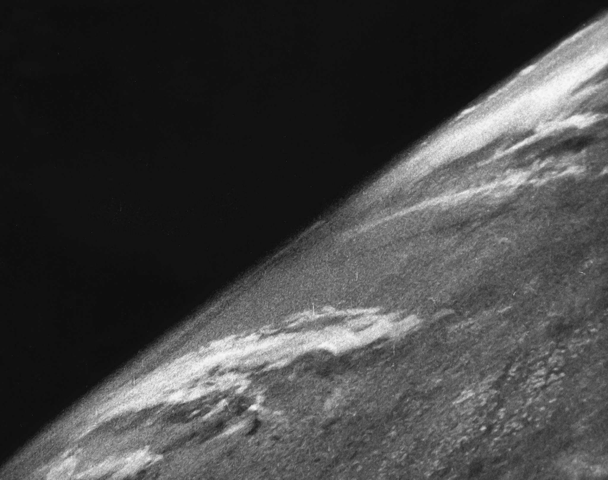
Satellite images (also Earth observation imagery, spaceborne photography, or simply satellite photo) are images of Earth collected by imaging satellites operated by governments and businesses around the world. Satellite imaging companies sell images by licensing them to governments and businesses such as Apple Maps and Google Maps. History The first images from space were taken on Sub-orbital spaceflight, sub-orbital flights. The US-launched V-2 flight on October 24, 1946, took one image every 1.5 seconds. With an Apsis, apogee of 65 miles (105 km), these photos were from five times higher than the previous record, the 13.7 miles (22 km) by the Explorer II balloon mission in 1935. The first satellite (orbital) photographs of Earth were made on August 14, 1959, by the U.S. Explorer 6. The first satellite photographs of the Moon might have been made on October 6, 1959, by the Soviet satellite Luna 3, on a mission to photograph the far side of the Moon. The Blue Marble ... [...More Info...] [...Related Items...] OR: [Wikipedia] [Google] [Baidu] |
Eye (cyclone)
The eye is a region of mostly calm weather at the center of a tropical cyclone. The eye of a storm is a roughly circular area, typically in diameter. It is surrounded by the eyewall, a ring of towering thunderstorms where the most severe weather and highest winds of the cyclone occur. The cyclone's lowest barometric pressure occurs in the eye and can be as much as 15 percent lower than the pressure outside the storm. In strong tropical cyclones, the eye is characterized by light winds and clear skies, surrounded on all sides by a towering, symmetric eyewall. In weaker tropical cyclones, the eye is less well defined and can be covered by the central dense overcast, an area of high, thick clouds that show up brightly on satellite imagery. Weaker or disorganized storms may also feature an eyewall that does not completely encircle the eye or have an eye that features heavy rain. In all storms, however, the eye is where the barometer reading is lowest. Structure A typical tropi ... [...More Info...] [...Related Items...] OR: [Wikipedia] [Google] [Baidu] |
Rapid Intensification
Rapid intensification (RI) is any process wherein a tropical cyclone strengthens very dramatically in a short period of time. Tropical cyclone forecasting agencies utilize differing thresholds for designating rapid intensification events, though the most widely used definition stipulates an increase in the maximum sustained winds of a tropical cyclone of at least in a 24-hour period. However, periods of rapid intensification often last longer than a day. About 20–30% of all tropical cyclones undergo rapid intensification, including a majority of tropical cyclones with peak wind speeds exceeding . Rapid intensification constitutes a major source of error for tropical cyclone forecasting, and its predictability is commonly cited as a key area for improvement. The specific physical mechanisms that underlie rapid intensification and the environmental conditions necessary to support rapid intensification are unclear due to the complex interactions between the environment surr ... [...More Info...] [...Related Items...] OR: [Wikipedia] [Google] [Baidu] |
Central Dense Overcast
The central dense overcast, or CDO, of a tropical cyclone or strong subtropical cyclone is the large central area of thunderstorms surrounding its circulation center, caused by the formation of its eyewall. It can be round, angular, oval, or irregular in shape. This feature shows up in tropical cyclones of tropical storm or hurricane strength. How far the center is embedded within the CDO, and the temperature difference between the cloud tops within the CDO and the cyclone's eye, can help determine a tropical cyclone's intensity with the Dvorak technique. Locating the center within the CDO can be a problem with strong tropical storms and minimal hurricanes as its location can be obscured by the CDO's high cloud canopy. This center location problem can be resolved through the use of microwave satellite imagery. After a cyclone strengthens to around hurricane intensity, an eye appears at the center of the CDO, defining its center of low pressure and its cyclonic wind field. Tropi ... [...More Info...] [...Related Items...] OR: [Wikipedia] [Google] [Baidu] |
Subtropical Ridge
The horse latitudes are the latitudes about 30 degrees north and south of the Equator. They are characterized by sunny skies, calm winds, and very little precipitation. They are also known as subtropical ridges or highs. It is a high-pressure area at the divergence of trade winds and the westerlies. Etymology A likely and documented explanation is that the term is derived from the "dead horse" ritual of seamen (see Beating a dead horse). In this practice, the seaman paraded a straw-stuffed effigy of a horse around the deck before throwing it overboard. Seamen were paid partly in advance before a long voyage, and they frequently spent their pay all at once, resulting in a period of time without income. This period was called the "dead horse" time, and it usually lasted a month or two. The seaman's ceremony was to celebrate having worked off the "dead horse" debt. As west-bound shipping from Europe usually reached the subtropics at about the time the "dead horse" was worke ... [...More Info...] [...Related Items...] OR: [Wikipedia] [Google] [Baidu] |
Outflow (meteorology)
Outflow, in meteorology, is air that flows outwards from a storm system. It is associated with ridging, or anticyclone, anticyclonic flow. In the low levels of the troposphere, outflow radiates from thunderstorms in the form of a wedge of rain-cooled air, which is visible as a thin rope-like cloud on weather satellite imagery or a fine line on weather radar imagery. For observers on the ground, a thunderstorm outflow boundary often approaches in otherwise clear skies as a low, thick cloud that brings with it a gust front. Low-level outflow boundaries can disrupt the center of small tropical cyclones. However, outflow aloft is essential for the strengthening of a tropical cyclone. If this outflow is restricted or undercut, the tropical cyclone weakens. If two tropical cyclones are close, the upper-level outflow from the upwind system can limit the development of the other system. Thunderstorms For thunderstorms, outflow tends to indicate the development of a system. Large quan ... [...More Info...] [...Related Items...] OR: [Wikipedia] [Google] [Baidu] |
Wind Shear
Wind shear (; also written windshear), sometimes referred to as wind gradient, is a difference in wind speed and/or direction over a relatively short distance in the atmosphere. Atmospheric wind shear is normally described as either vertical or horizontal wind shear. Vertical wind shear is a change in wind speed or direction with a change in altitude. Horizontal wind shear is a change in wind speed with a change in lateral position for a given altitude. Wind shear is a microscale meteorological phenomenon occurring over a very small distance, but it can be associated with mesoscale or synoptic scale weather features such as squall lines and cold fronts. It is commonly observed near microbursts and downbursts caused by thunderstorms, fronts, areas of locally higher low-level winds referred to as low-level jets, near mountains, radiation inversions that occur due to clear skies and calm winds, buildings, wind turbines, and sailboats. Wind shear has significant effects on ... [...More Info...] [...Related Items...] OR: [Wikipedia] [Google] [Baidu] |


