|
Transdanubian Hungary
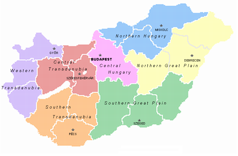
Transdanubia ( hu, Dunántúl; german: Transdanubien, hr, Prekodunavlje or ', sk, Zadunajsko :sk:Zadunajsko) is a traditional region of Hungary. It is also referred to as Hungarian Pannonia, or Pannonian Hungary. Administrative divisions Traditional interpretation The borders of Transdanubia are the Danube River (north and east), the Drava and Mura rivers (south), and the foothills of the Alps roughly along the border between Hungary and Austria (west). Transdanubia comprises the counties of Győr-Moson-Sopron, Komárom-Esztergom, Fejér, Veszprém, Vas, Zala, Somogy, Tolna, Baranya and the part of Pest that lies west of the Danube. (In the early Middle Ages the latter was known as Pilis county.) This article deals with Transdanubia in this geographical meaning. Territorial changes While the northern, eastern and southern borders of the region are clearly marked by the Danube and Drava rivers, the western border was always identical with the political bounda ... [...More Info...] [...Related Items...] OR: [Wikipedia] [Google] [Baidu] |
Ibafa
Ibafa ( hr, Ibaba) is a small village with a population of 250 in Baranya county, Hungary. The village is in the valleys of Zselic. The mayor is László Benes. Ibafa became known in the 20th century, because the local priest liked pipes. He was a strange ecclesiastical person, always seen with a pipe in his mouth, playing cards with pals in the pub. A journalist stumbled on him, and wrote a tongue-twister verse beginning with the line: :"Az ibafai papnak fapipája van, ezért az ibafai papi pipa papi fapipa" meaning :"The priest of Ibafa has a wooden pipe, so the priestly pipe of Ibafa is a priestly wooden pipe". Sights There is a Pipe Museum in the village, where you can find the pipe of Ferenc Deák and Mihály Károlyi Count Mihály Ádám György Miklós Károlyi de Nagykároly ( hu, gróf nagykárolyi Károlyi Mihály Ádám György Miklós; archaically English: Michael Adam George Nicholas Károlyi, or in short simple form: Michael Károlyi; 4 March 1875 � .... ... [...More Info...] [...Related Items...] OR: [Wikipedia] [Google] [Baidu] |
Pannonia
Pannonia (, ) was a province of the Roman Empire bounded on the north and east by the Danube, coterminous westward with Noricum and upper Italy, and southward with Dalmatia and upper Moesia. Pannonia was located in the territory that is now western Hungary, western Slovakia, eastern Austria, northern Croatia, north-western Serbia, northern Slovenia, and northern Bosnia and Herzegovina. Name Julius Pokorny believed the name ''Pannonia'' is derived from Illyrian, from the Proto-Indo-European root ''*pen-'', "swamp, water, wet" (cf. English ''fen'', "marsh"; Hindi ''pani'', "water"). Pliny the Elder, in '' Natural History'', places the eastern regions of the Hercynium jugum, the "Hercynian mountain chain", in Pannonia and Dacia (now Romania). He also gives us some dramaticised description of its composition, in which the proximity of the forest trees causes competitive struggle among them (''inter se rixantes''). He mentions its gigantic oaks. But even he—if the passage in ... [...More Info...] [...Related Items...] OR: [Wikipedia] [Google] [Baidu] |
Rusovce
Rusovce ( hu, Oroszvár, hr, Rosvar german: Karlburg, Rossenburg, Kerchenburg) is a borough in southern Bratislava on the right bank of the Danube river, close to the Austrian border. History In the 1st century, there was a Roman settlement named Gerulata in today's Rusovce area. The first preserved written reference to the settlement is from 1208. In 1910 Oroszvár had 1.802 inhabitants. Among them were 1.268 Germans, 439 Hungarians, 30 Slovaks, 20 Croats and 39 Others. It remained Hungarian after 1920 but became a border village close to Austria and Czechoslovakia. The German inhabitants were expulsed after 1945. On October 15, 1947 - together with Čunovo and Jarovce - Rusovce became part of Czechoslovakia according to the Paris Peace Treaty. On January 1, 1972, it was made a borough of Bratislava. Transport A motorway and road border crossings into Hungary are located in Rusovce. Across the border is Rajka in Győr-Moson-Sopron County. There are no more border chec ... [...More Info...] [...Related Items...] OR: [Wikipedia] [Google] [Baidu] |
Prekmurje
Prekmurje (; dialectically: ''Prèkmürsko'' or ''Prèkmüre''; hu, Muravidék) is a geographically, linguistically, culturally and ethnically defined region of Slovenia, settled by Slovenes and a Hungarian minority, lying between the Mur River in Slovenia and the Rába Valley (the watershed of the Rába; sl, Porabje) in the westernmost part of Hungary. It maintains certain specific linguistic, cultural and religious features that differentiate it from other Slovenian traditional regions. It covers an area of and has a population of 78,000 people. Name It is named after the Mur River, which separates it from the rest of Slovenia (a literal translation from Slovene would be ''Over-Mur'' or ''Transmurania''). In Hungarian, the region is known as ''Muravidék'', and in German as ''Übermurgebiet''. The name Prekmurje was introduced in the twentieth century, although it is derived from an older term. Before 1919, the Slovenian-inhabited lands of Vas County in the King ... [...More Info...] [...Related Items...] OR: [Wikipedia] [Google] [Baidu] |
Burgenland
Burgenland (; hu, Őrvidék; hr, Gradišće; Austro-Bavarian: ''Burgnland;'' Slovene: ''Gradiščanska'') is the easternmost and least populous state of Austria. It consists of two statutory cities and seven rural districts, with a total of 171 municipalities. It is long from north to south but much narrower from west to east ( wide at Sieggraben). The region is part of the Centrope Project. Geography Burgenland is the third-smallest of Austria's nine states, or ''Bundesländer'', at . The highest point in the province is exactly on the border with Hungary, on the Geschriebenstein, above sea level. The highest point entirely within Burgenland is 879 metres above sea level; the lowest point (which is also the lowest point of Austria) at , is in the municipal area of Apetlon. Burgenland borders the Austrian state of Styria to the southwest, and the state of Lower Austria to the northwest. To the east it borders Hungary ( Vas County and Győr-Moson-Sopron County). In ... [...More Info...] [...Related Items...] OR: [Wikipedia] [Google] [Baidu] |
Treaty Of Trianon
The Treaty of Trianon (french: Traité de Trianon, hu, Trianoni békeszerződés, it, Trattato del Trianon) was prepared at the Paris Peace Conference and was signed in the Grand Trianon château in Versailles on 4 June 1920. It formally ended World War I between most of the Allies of World War I and the Kingdom of Hungary. French diplomats played the major role in designing the treaty, with a view to establishing a French-led coalition of the newly formed states. It regulated the status of the Kingdom of Hungary and defined its borders generally within the ceasefire lines established in November–December 1918 and left Hungary as a landlocked state that included , 28% of the that had constituted the pre-war Kingdom of Hungary (the Hungarian half of the Austro-Hungarian monarchy). The truncated kingdom had a population of 7.6 million, 36% compared to the pre-war kingdom's population of 20.9 million. Though the areas that were allocated to neighbouring countries had a ... [...More Info...] [...Related Items...] OR: [Wikipedia] [Google] [Baidu] |
Pilis County
Pilis () is a town in Pest County, Hungary. History The town was inhabited in prehistoric times, but was abandoned at the end of the Roman rule. Pilis was then first mentioned in 1326. It was destroyed during the Ottoman rule in the 16th century, and was reestablished only in 1711, by János Beleznay, the local landlord. He brought Slovak settlers from Upper Hungary, and built a palace in 1717 for himself and his family. The Beleznay family sold the town and its surroundings in the 19th century to the Nyári family, who renamed the palace to "Beleznay-Nyári palace". Even though the town's ethnic composition has changed in the last centuries, there is still a sizable Slovak minority which has its own local government that is responsible for keeping the Slovak traditions and memories of Pilis. Etymology The name comes from Slavic ''Pleš'' – bald (area or mountain), an area with sparse or missing trees or vegetation. There are similar names in several Slavic countries ... [...More Info...] [...Related Items...] OR: [Wikipedia] [Google] [Baidu] |
Baranya (county)
Baranya ( hu, Baranya megye, ) is a county () in southern Hungary. It is part of the Southern Transdanubia statistical region and the historical Baranya region, which was a county ('' comitatus'') in the Kingdom of Hungary dating back to the 11th century. Its current status as one of the 19 counties of Hungary was established in 1950 as part of wider Soviet administrative territorial reform following World War II. It is bordered by Somogy County to the northwest, Tolna County to the north, Bács-Kiskun County and the Danube to the east, and the border with Croatia (part of which is formed by the Drava River) to the south. As of the 2011 census, it had a population of 386,441 residents. Of the 19 counties of Hungary (excluding Budapest), it is ranked 10th by both geographic area and population. Its county seat and largest city is Pécs. Etymology In German, it is known as , and in Croatian as . The county was probably named after its first comes 'Brana' or 'Braina'. Ge ... [...More Info...] [...Related Items...] OR: [Wikipedia] [Google] [Baidu] |
Tolna (county)
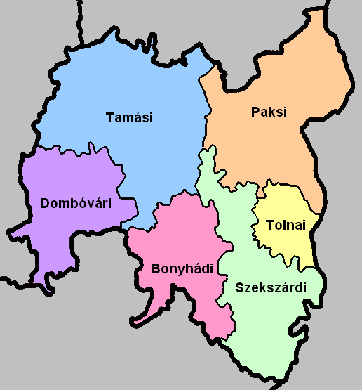
Tolna ( hu, Tolna megye, ; german: Komitat Tolnau) is an administrative county (comitatus or megye) in present Hungary as it was of the former Kingdom of Hungary. It lies in central Hungary, on the west bank of the river Danube. It shares borders with the Hungarian counties Somogy, Fejér, Bács-Kiskun, and Baranya. The capital of Tolna county is Szekszárd. Its area is 3703 km2. History Tolna (in Latin: ''comitatus Tolnensis'') was also the name of a historic administrative county (comitatus) of the Kingdom of Hungary. Its territory, which was about the same as that of present Tolna county, is now in central Hungary. The capital of the county was Szekszárd. Demographics In 2015, it had a population of 225,936 and the population density was . Ethnicity Besides the Hungarian majority, the main minorities are the Germans (approx. 10,000) and Roma (8,500). Total population (2011 census): 230,361 Ethnic groups (2011 census): Identified themselves: 214 953 persons: *H ... [...More Info...] [...Related Items...] OR: [Wikipedia] [Google] [Baidu] |


