|
Tinée
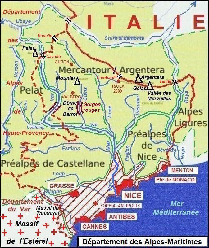
The Tinée (; ) is a river that flows through the Alpes-Maritimes department of southeastern France. It is long. Its drainage basin is .Bassin versant : Tinée (La) Observatoire Régional Eau et Milieux Aquatiques en PACA Its source is on the east side of the Col de la Bonette, in the . It flows through , [...More Info...] [...Related Items...] OR: [Wikipedia] [Google] [Baidu] |
Saint-Étienne-de-Tinée
Saint-Étienne-de-Tinée (, literally ''Saint-Étienne of Tinée''; ; Vivaro-Alpine: ''Sant Estève d'en Tiniá'') is a commune in the Alpes-Maritimes department in southeastern France. It was part of the historic County of Nice until 1860. The ski resort of Auron is located on the territory of the commune, and linked to the village of Saint-Étienne-de-Tinée directly by a gondola lift. Population See also *Communes of the Alpes-Maritimes department The following is a list of the 163 communes of the Alpes-Maritimes department of France France, officially the French Republic, is a country located primarily in Western Europe. Overseas France, Its overseas regions and territories inclu ... References External links Communes of Alpes-Maritimes Alpes-Maritimes communes articles needing translation from French Wikipedia {{AlpesMaritimes-geo-stub ... [...More Info...] [...Related Items...] OR: [Wikipedia] [Google] [Baidu] |
Alpes-Maritimes
Alpes-Maritimes (; ; ; ) is a Departments of France, department of France located in the country's southeast corner, on the France–Italy border, Italian border and Mediterranean Sea, Mediterranean coast. Part of the Provence-Alpes-Côte d'Azur Regions of France, region, it encompasses the French Riviera alongside neighbouring Var (department), Var. Alpes-Maritimes had a population of 1,094,283 in 2019.Populations légales 2019: 06 Alpes-Maritimes INSEE Its Prefectures in France, prefecture (and largest city) is Nice, with Grasse as the sole Subprefectures in France, subprefecture. Alpes-Maritimes has become one of the world's most attractive tourist destinations in recent decades, featuring renowned cities and towns such as Nice, Grasse, Cannes, Antibes, Menton, Èze, Roquebrune-Ca ... [...More Info...] [...Related Items...] OR: [Wikipedia] [Google] [Baidu] |
Saint-Sauveur-sur-Tinée
Saint-Sauveur-sur-Tinée (, literally ''Saint-Sauveur on Tinée''; Vivaro-Alpine: ''Sant Sarvaor''; ) is a commune in the Alpes-Maritimes department in the Provence-Alpes-Côte d'Azur region in southeastern France. Population Its inhabitants are called ''Blavets'' or ''Sansavornins'' in French. See also *Communes of the Alpes-Maritimes department The following is a list of the 163 communes of the Alpes-Maritimes department of France France, officially the French Republic, is a country located primarily in Western Europe. Overseas France, Its overseas regions and territories inclu ... References Communes of Alpes-Maritimes Alpes-Maritimes communes articles needing translation from French Wikipedia {{AlpesMaritimes-geo-stub ... [...More Info...] [...Related Items...] OR: [Wikipedia] [Google] [Baidu] |
Vionène
The Vionène is a small river that flows through the Alpes-Maritimes department of southeastern France. It flows into the Tinée in Saint-Sauveur-sur-Tinée Saint-Sauveur-sur-Tinée (, literally ''Saint-Sauveur on Tinée''; Vivaro-Alpine: ''Sant Sarvaor''; ) is a commune in the Alpes-Maritimes department in the Provence-Alpes-Côte d'Azur region in southeastern France. Population Its inhabita .... It is long. References Rivers of France Rivers of Alpes-Maritimes Rivers of Provence-Alpes-Côte d'Azur {{France-river-stub ... [...More Info...] [...Related Items...] OR: [Wikipedia] [Google] [Baidu] |
Maritime Alps
The Maritime Alps ( ; ) are a mountain range in the southwestern part of the Alps. They form the border between the regions of France, French region of Provence-Alpes-Côte d'Azur and the regions of Italy, Italian regions of Piedmont and Liguria. They are the southernmost part of the Alps. Geography Administratively the range is divided between the Provinces of Italy, Italian provinces of Province of Cuneo, Cuneo and Province of Imperia, Imperia (eastern slopes) and the Departments of France, French department of Alpes-Maritimes (western slopes). The Maritime Alps are drained by the rivers Roya (river), Roya, Var River, Var and Verdon River, Verdon and their tributaries on the French side; by the Stura di Demonte and other tributaries of the Tanaro River, Tanaro and Po River, Po on the Italian side. There are many attractive perched villages, such as Belvédère at the entrance to the spectacular Gordolasque valley, some concealing unexpected architectural riches (for example ... [...More Info...] [...Related Items...] OR: [Wikipedia] [Google] [Baidu] |
Guercha
The Guercha is a short mountain river that flows through the Alpes-Maritimes department of southeastern France. It is long. Its source is in the Maritime Alps, close to the Italian border. It flows into the Tinée The Tinée (; ) is a river that flows through the Alpes-Maritimes department of southeastern France. It is long. Its drainage basin is .Isola. References Rivers of France Rivers of Alpes-Maritimes Rivers of Provence-Alpes-Côte d'Azur { ...[...More Info...] [...Related Items...] OR: [Wikipedia] [Google] [Baidu] |
Var (river)
The Var (, ; ; ) is a river located in the southeast of France. It is long. Its drainage basin is .Bassin versant : Var (Le) Observatoire Régional Eau et Milieux Aquatiques en PACA The Var flows through the '''' for most of its length, with a short (~15 km or ~9 mi) stretch in the ''département''. It is a unique case in France of a ... [...More Info...] [...Related Items...] OR: [Wikipedia] [Google] [Baidu] |
Col De La Bonette
Col de la Bonette (el. ) is a high mountain pass in the French Alps, near the border with Italy. It is situated within the Mercantour National Park on the border of the departments of Alpes-Maritimes and Alpes-de-Haute-Provence. The road over the col is the eight highest paved road in the Alps. Col de Restefond The passage over the Col de la Bonette is often mistakenly referred to as the '' Col de Restefond'', and in the 2008 Tour de France the summit was referred to as the ''Cime de la Bonette-Restefond''. Stage 16 of the tour approached the summit from Saint-Étienne-de-Tinée (south-east), and after reaching the Col de la Bonette, took a loop round the Cime de la Bonette reaching the summit of , which is the highest point reached by the Tour de France, before re-passing the Col de la Bonette. On the descent to Jausiers, the actual Col de Restefond was then passed on the right approximately 1 km from the summit. “Highest road in Europe” The two kilometre long te ... [...More Info...] [...Related Items...] OR: [Wikipedia] [Google] [Baidu] |
Rivers Of France
This is a list of rivers that are at least partially in France. The rivers are grouped by sea or ocean. The rivers flowing into the sea are sorted along the coast. Rivers flowing into other rivers are listed by the rivers they flow into. Some rivers (e.g. Sûre/Sauer) do not flow through France themselves, but they are mentioned for having French tributaries. They are given in ''italics''. For clarity, only rivers that are longer than 50 km (or have longer tributaries) are shown. In French, rivers are traditionally classified either as ''fleuves'' when they flow into the sea (or into a desert or lake), or as ''rivières'' when they flow into another river. The ''fleuves'' are shown in bold. For an alphabetical overview of rivers of France, see the category Rivers of France. Tributary list North Sea The rivers in this section are sorted north-east (Netherlands) to south-west (Calais). * Rhine/Rhin (main branch at Hook of Holland, Netherlands) ** Moselle (in Koblenz, Germ ... [...More Info...] [...Related Items...] OR: [Wikipedia] [Google] [Baidu] |
France
France, officially the French Republic, is a country located primarily in Western Europe. Overseas France, Its overseas regions and territories include French Guiana in South America, Saint Pierre and Miquelon in the Atlantic Ocean#North Atlantic, North Atlantic, the French West Indies, and List of islands of France, many islands in Oceania and the Indian Ocean, giving it Exclusive economic zone of France, one of the largest discontiguous exclusive economic zones in the world. Metropolitan France shares borders with Belgium and Luxembourg to the north; Germany to the northeast; Switzerland to the east; Italy and Monaco to the southeast; Andorra and Spain to the south; and a maritime border with the United Kingdom to the northwest. Its metropolitan area extends from the Rhine to the Atlantic Ocean and from the Mediterranean Sea to the English Channel and the North Sea. Its Regions of France, eighteen integral regions—five of which are overseas—span a combined area of and hav ... [...More Info...] [...Related Items...] OR: [Wikipedia] [Google] [Baidu] |
River
A river is a natural stream of fresh water that flows on land or inside Subterranean river, caves towards another body of water at a lower elevation, such as an ocean, lake, or another river. A river may run dry before reaching the end of its course if it runs out of water, or only flow during certain seasons. Rivers are regulated by the water cycle, the processes by which water moves around the Earth. Water first enters rivers through precipitation, whether from rainfall, the Runoff (hydrology), runoff of water down a slope, the melting of glaciers or snow, or seepage from aquifers beneath the surface of the Earth. Rivers flow in channeled watercourses and merge in confluences to form drainage basins, or catchments, areas where surface water eventually flows to a common outlet. Rivers have a great effect on the landscape around them. They may regularly overflow their Bank (geography), banks and flood the surrounding area, spreading nutrients to the surrounding area. Sedime ... [...More Info...] [...Related Items...] OR: [Wikipedia] [Google] [Baidu] |
Isola, Alpes-Maritimes
Isola (; ) is a commune of the Alpes-Maritimes department in southeastern France. The Alpine ski resort of Isola 2000 is located on the territory of the commune. Geography Climate Isola has a subarctic climate (Köppen climate classification The Köppen climate classification divides Earth climates into five main climate groups, with each group being divided based on patterns of seasonal precipitation and temperature. The five main groups are ''A'' (tropical), ''B'' (arid), ''C'' (te ... ''Dfc''). The average annual temperature in Isola is . The average annual rainfall is with November as the wettest month. The temperatures are highest on average in July, at around , and lowest in January, at around . The highest temperature ever recorded in Isola was on 19 July 2023; the coldest temperature ever recorded was on 4 February 1978. Population International relations Since April 2010, Isola has been officially twinned with Castiglione di Garfagnana. See also ... [...More Info...] [...Related Items...] OR: [Wikipedia] [Google] [Baidu] |


