|
Tiltmeter
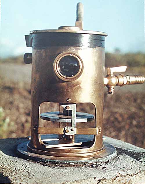
A tiltmeter is a sensitive inclinometer designed to measure very small changes from the vertical level, either on the ground or in structures. Tiltmeters are used extensively for monitoring volcanoes, the response of dams to filling, the small movements of potential landslides, the orientation and volume of Hydraulic fracturing, hydraulic fractures, and the response of structures to various influences such as loading and foundation settlement. Tiltmeters may be purely mechanical or incorporate vibrating-wire or electrolytic sensors for electronic measurement. A sensitive instrument can detect changes of as little as one Minute of arc, arc second. Tiltmeters have a long, diverse history, somewhat parallel to the history of the seismometer. The very first tiltmeter was a long-length stationary pendulum. These were used in the very first large concrete dams, and are still in use today, augmented with newer technology such as laser reflectors. Although they had been used for other ... [...More Info...] [...Related Items...] OR: [Wikipedia] [Google] [Baidu] |
Inclinometer
An inclinometer or clinometer is an measuring instrument, instrument used for measuring angles of slope, elevation, or depression (geology), depression of an object with respect to gravity's direction. It is also known as a ''tilt indicator'', ''tilt sensor'', tiltmeter, ''tilt meter'', ''slope alert'', ''slope gauge'', ''gradient meter'', ''gradiometer'', ''level gauge'', ''level meter'', ''declinometer'', and ''pitch & roll indicator''. Clinometers measure both inclines and declines using three different units of measure: degree (angle), degrees, percentage points, and topos. The Astrolabes, astrolabe is an example of an inclinometer that was used for celestial navigation and location of astronomical objects from ancient history, ancient times to the Renaissance. A ''tilt sensor'' can measure the wikt:tilt, tilting in often two axes of a reference plane in two axes. In contrast, a full motion would use at least three axes and often additional sensors. One way to measure tilt a ... [...More Info...] [...Related Items...] OR: [Wikipedia] [Google] [Baidu] |
Dam Safety System
Dam safety systems are used to monitor the state of dams, including external physical threats to the dams, and issuing emergency warnings at various degrees of automation. This includes the use of differential GPS and Synthetic aperture radar, SAR remote sensing to monitor the risks imposed by landslides and subsidence. For large dams, seismographs are used to detect reservoir-induced seismicity that could threaten the stability of the dam. The output of these systems can emergency population warning, provide warning to the local population ahead of a potential collapse. Particular applications Ukraine The monitoring and warning system safeguarding the Kyiv Reservoir dam is complicated enough to include protection from a Impact event, space object impact. Italy The dam monitoring system of Enel green Power in the Riolunato Dam controls all of the dam's important parameters. Optical and physical alignment systems are installed to control any movement of the land under and around t ... [...More Info...] [...Related Items...] OR: [Wikipedia] [Google] [Baidu] |
Deformation (volcanology)
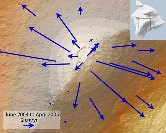
In volcanology, deformation refers to the change in the shape of a volcano or the surrounding landscape due to the movement of magma. This can be in the form of inflation, which is a response to pressurization, or deflation, which is a response to depressurization. Inflation is represented by swelling of the ground surface, a volcanic edifice, or a subsurface magma body. It can be caused by magma accumulation, exsolution of Volatile (astrogeology), volatiles, Geothermal energy, geothermal processes, heating, and tectonic Compression (geology), compression. Deflation is represented by shrinking of the ground surface, a volcanic edifice, or a subsurface magma body. It can be caused by magma withdrawal (related to intrusion or Types of volcanic eruptions, eruption), volatile escape, thermal contraction, phase changes during crystallization, and Extensional tectonics, tectonic extension. Deformation is a key indicator of pre-eruptive unrest at many active volcanoes, but deformation si ... [...More Info...] [...Related Items...] OR: [Wikipedia] [Google] [Baidu] |
Volcanology
Volcanology (also spelled vulcanology) is the study of volcanoes, lava, magma and related geology, geological, geophysical and geochemistry, geochemical phenomena (volcanism). The term ''volcanology'' is derived from the Latin language, Latin word ''Vulcan (mythology), vulcan''. Vulcan was the ancient Roman mythology, Roman god of fire. A volcanologist is a geologist who studies the eruptive activity and formation of volcanoes and their current and historic eruptions. Volcanologists frequently visit volcanoes, especially active ones, to observe volcanic eruptions, collect eruptive products including tephra (such as Volcanic ash, ash or pumice), Rock (geology), rock and lava samples. One major focus of enquiry is the prediction of eruptions; there is currently no accurate way to do this, but predicting or forecasting eruptions, like predicting earthquakes, could save many lives. Modern volcanology image:Icelandic tephra.JPG, Volcanologist examining tephra horizons in south- ... [...More Info...] [...Related Items...] OR: [Wikipedia] [Google] [Baidu] |
Pendulum
A pendulum is a device made of a weight suspended from a pivot so that it can swing freely. When a pendulum is displaced sideways from its resting, equilibrium position, it is subject to a restoring force due to gravity that will accelerate it back toward the equilibrium position. When released, the restoring force acting on the pendulum's mass causes it to oscillate about the equilibrium position, swinging back and forth. The time for one complete cycle, a left swing and a right swing, is called the period. The period depends on the length of the pendulum and also to a slight degree on the amplitude, the width of the pendulum's swing. Pendulums were widely used in early mechanical clocks for timekeeping. The regular motion of pendulums was used for timekeeping and was the world's most accurate timekeeping technology until the 1930s. The pendulum clock invented by Christiaan Huygens in 1656 became the world's standard timekeeper, used in homes and offices for 270 years, and ... [...More Info...] [...Related Items...] OR: [Wikipedia] [Google] [Baidu] |
Differential GPS
Differential Global Positioning Systems (DGPSs) supplement and enhance the positional data available from global navigation satellite systems (GNSSs). A DGPS can increase accuracy of positional data by about a thousandfold, from approximately to . DGPSs consist of networks of fixed position, ground-based reference stations. Each reference station calculates the difference between its highly accurate known position and its less accurate satellite-derived position. The stations broadcast this data locally—typically using ground-based transmitters of shorter range. Non-fixed (mobile) receivers use it to correct their position by the same amount, thereby improving their accuracy. The United States Coast Guard (USCG) previously ran DGPS in the United States on longwave radio frequencies between and near major waterways and harbors. It was discontinued in March 2022. The USCG's DGPS was known as NDGPS (Nationwide DGPS) and was jointly administered by the Coast Guard and the United ... [...More Info...] [...Related Items...] OR: [Wikipedia] [Google] [Baidu] |
Seismology Instruments
Seismology (; from Ancient Greek σεισμός (''seismós'') meaning "earthquake" and -λογία (''-logía'') meaning "study of") is the scientific study of earthquakes (or generally, quakes) and the generation and propagation of elastic waves through planetary bodies. It also includes studies of the environmental effects of earthquakes such as tsunamis; other seismic sources such as volcanoes, plate tectonics, glaciers, rivers, oceanic microseisms, and the atmosphere; and artificial processes such as explosions. Paleoseismology is a related field that uses geology to infer information regarding past earthquakes. A recording of Earth's motion as a function of time, created by a seismograph is called a seismogram. A seismologist is a scientist who works in basic or applied seismology. History Scholarly interest in earthquakes can be traced back to antiquity. Early speculations on the natural causes of earthquakes were included in the writings of Thales of Miletus (), An ... [...More Info...] [...Related Items...] OR: [Wikipedia] [Google] [Baidu] |
Volcano
A volcano is commonly defined as a vent or fissure in the crust of a planetary-mass object, such as Earth, that allows hot lava, volcanic ash, and gases to escape from a magma chamber below the surface. On Earth, volcanoes are most often found where tectonic plates are diverging or converging, and because most of Earth's plate boundaries are underwater, most volcanoes are found underwater. For example, a mid-ocean ridge, such as the Mid-Atlantic Ridge, has volcanoes caused by divergent tectonic plates whereas the Pacific Ring of Fire has volcanoes caused by convergent tectonic plates. Volcanoes resulting from divergent tectonic activity are usually non-explosive whereas those resulting from convergent tectonic activity cause violent eruptions."Mid-ocean ridge tectonics, volcanism and geomorphology." Geology 26, no. 455 (2001): 458. https://macdonald.faculty.geol.ucsb.edu/papers/Macdonald%20Mid-Ocean%20Ridge%20Tectonics.pdf Volcanoes can also form where there is str ... [...More Info...] [...Related Items...] OR: [Wikipedia] [Google] [Baidu] |
Tilt Test (geotechnical Engineering)
In geomechanics, a tilt test is a simple test to estimate the shear strength (discontinuity), shear strength parameters of a Discontinuity (geotechnical engineering), discontinuity. Two pieces of rock containing a discontinuity are held in hand or mounted in test equipment with the discontinuity horizontal. The sample is slowly tilted until the top block moves. The angle with the horizontal at onset of movement is called the ''tilt-angle''. The size of the specimen is limited to 10–20 cm for hand-held tests, while machine-operated tilt test equipment may handle up to meter-sized samples. In the field, the angle can be determined most easily with an inclinometer as present in most compass, geological or structural compasses. Tilt-angle The ''tilt-angle'' equals the material friction of the Discontinuity (geotechnical engineering), discontinuity wall plus the roughness i-angle (''tilt-angle'' = ''φwall material'' + ''i'') if no real cohesion is present (i.e. no cementing or g ... [...More Info...] [...Related Items...] OR: [Wikipedia] [Google] [Baidu] |


