|
Thaumasia Planum
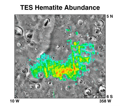
The Thaumasia Planum of Mars lies south of Melas Chasmata and Coprates Chasmata. It is in the Coprates quadrangle. Its center is located at 21.66 S and 294.78 E. It was named after a classical albedo feature. The name was approved in 2006. Some forms on its surface are evidence of a flow of lava or water the Melas Chasma. Many wrinkle ridges and grabens are visible. One set of grabens, called Nia Fossae, seem to follow the curve of Melas Chasmata which lies just to the north. Some researchers have discovered dikes in this region. For the study, Thermal Emission Imaging System (THEMIS) daytime infrared images, THEMIS nighttime infrared images, CTX images, and HiRISE images were used. These dikes contain magnesium-rich olivine which indicates a primitive magma composition. Dikes occur when magma follows cracks and faults under the ground. Sometimes erosion reveals them. The presence of pit craters, narrow grabens, linear troughs, and ovoid troughs are also evidence o ... [...More Info...] [...Related Items...] OR: [Wikipedia] [Google] [Baidu] |
Thermal Emission Imaging System
The Thermal Emission Imaging System (THEMIS) is a camera on board the 2001 Mars Odyssey orbiter. It images Mars in the visible and infrared parts of the electromagnetic spectrum in order to determine the thermal properties of the surface and to refine the distribution of minerals on the surface of Mars as determined by the Thermal Emission Spectrometer (TES). Additionally, it helps scientists to understand how the mineralogy of Mars relates to its landforms, and it can be used to search for thermal hotspots in the Martian subsurface. THEMIS is managed from the Mars Space Flight Facility at Arizona State University and was built by the Santa Barbara Remote Sensing division of Raytheon Technologies Corporation, an American multinational conglomerate headquartered in Waltham, Massachusetts. The instrument is named after Themis, the goddess of justice in ancient Greek mythology. Infrared camera THEMIS detects thermal infrared energy emitted by the Martian surface at nin ... [...More Info...] [...Related Items...] OR: [Wikipedia] [Google] [Baidu] |
List Of Plains On Mars
This is a list of plains on Mars. Such features are named after the nearest classical albedo feature in compliance with the International Astronomical Union's rules of planetary nomenclature. Plains may be named denoted "planitia" or "planum", depending on height. Planitia Planitia (plural: planitiae) is Latin for plain. It is the IAU descriptor term for features which are "low plains". Plana Planum (plural: plana) is the Latin word for plateau. It is the IAU descriptor term for plateaus and high plains. Interactive Mars map References This article was based on the USGS The United States Geological Survey (USGS), formerly simply known as the Geological Survey, is a scientific agency of the United States government. The scientists of the USGS study the landscape of the United States, its natural resources, a ...'Gazetteer of Planetary Nomenclature * — current list of ''planitiae'' on Mars * — current list of ''plana'' on Mars External links ... [...More Info...] [...Related Items...] OR: [Wikipedia] [Google] [Baidu] |
Mars Reconnaissance Orbiter
''Mars Reconnaissance Orbiter'' (MRO) is a spacecraft designed to study the geology and climate of Mars, provide reconnaissance of future landing sites, and relay data from surface missions back to Earth. It was launched on August 12, 2005, and reached Mars on March 10, 2006. In November 2006, after five months of aerobraking, it entered its final science orbit and began its primary science phase. The cost to develop and operate MRO through the end of its prime mission in 2010 was . The spacecraft continues to operate at Mars, far beyond its intended design life. Due to its critical role as a high-speed data-relay for ground missions, NASA intends to continue the mission as long as possible, at least through the late 2020s. Pre-launch After the twin failures of the '' Mars Climate Orbiter'' and the Mars Polar Lander missions in 1999, NASA reorganized and replanned its Mars Exploration Program. In October 2000, NASA announced its reformulated Mars plans, which reduced the ... [...More Info...] [...Related Items...] OR: [Wikipedia] [Google] [Baidu] |
Lassell (Martian Crater)
Lassell may refer to: * Michael Lassell (born 1947), American writer and editor *William Lassell (1799–1880), English astronomer. Objects named after him include ** 2636 Lassell, a minor planet ** Lassell (lunar crater) Lassell is a small lunar impact crater that is located in the eastern part of the Mare Nubium. It was named after British astronomer William Lassell. It lies to the west of the crater Alpetragius and southwest of Alphonsus. Description Th ... ** Lassell (Martian crater) ** Mount Lassell in Antarctica {{disambiguation, surname, geo ... [...More Info...] [...Related Items...] OR: [Wikipedia] [Google] [Baidu] |
Valles Marineris
Valles Marineris (; Latin for '' Mariner Valleys'', named after the ''Mariner 9'' Mars orbiter of 1971–72 which discovered it) is a system of canyons that runs along the Martian surface east of the Tharsis region. At more than long, wide and up to deep, Valles Marineris is one of the largest canyons of the Solar System, surpassed in length only by the rift valleys of the mid-ocean ridge system of Earth. Valles Marineris is located along the equator of Mars, on the east side of the Tharsis Bulge, and stretches for nearly a quarter of the planet's circumference. The canyon system starts in the west with Noctis Labyrinthus; proceeding to the east are Tithonium and Ius chasmata, then Melas, Candor and Ophir chasmata, then Coprates Chasma, then Ganges, Capri and Eos chasmata; finally it empties into an outflow channel region containing chaotic terrain that ends in the basin of Chryse Planitia. It has been recently suggested that Valles Marineris is a large tectonic " ... [...More Info...] [...Related Items...] OR: [Wikipedia] [Google] [Baidu] |
Pit Crater
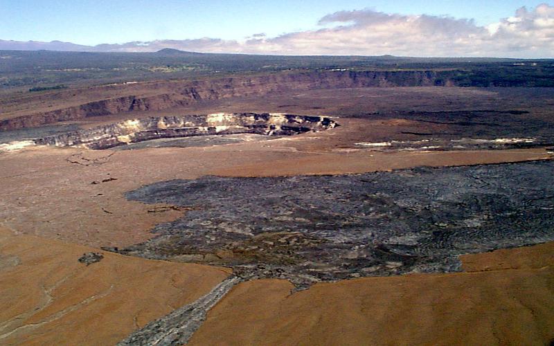
A pit crater (also called a subsidence crater or collapse crater) is a depression formed by a sinking or collapse of the surface lying above a void or empty chamber, rather than by the eruption of a volcano or lava vent. Pit craters are found on Mercury, Venus, Earth, Mars, and the Moon. Pit craters are often found in a series of aligned or offset chains and in these cases, the features is called a pit crater chain. Pit crater chains are distinguished from catenae or crater chains by their origin. When adjoining walls between pits in a pit crater chain collapse, they become troughs. In these cases, the craters may merge into a linear alignment and are commonly found along extensional structures such as fractures, fissures and graben. Pit craters usually lack an elevated rim as well as the ejecta deposits and lava flows that are associated with impact craters.Okubo, Chris, and Stephen Martel. "Pit crater formation on Kilauea volcano, Hawaii." Journal of Volcanology and Geothe ... [...More Info...] [...Related Items...] OR: [Wikipedia] [Google] [Baidu] |
Olivine
The mineral olivine () is a magnesium iron silicate with the chemical formula . It is a type of nesosilicate or orthosilicate. The primary component of the Earth's upper mantle, it is a common mineral in Earth's subsurface, but weathers quickly on the surface. For this reason, olivine has been proposed as a good candidate for accelerated weathering to sequester carbon dioxide from the Earth's oceans and atmosphere, as part of climate change mitigation. Olivine also has many other historical uses, such as the gemstone peridot (or chrysolite), as well as industrial applications like metalworking processes. The ratio of magnesium to iron varies between the two endmembers of the solid solution series: forsterite (Mg-endmember: ) and fayalite (Fe-endmember: ). Compositions of olivine are commonly expressed as molar percentages of forsterite (Fo) and fayalite (Fa) (''e.g.'', Fo70Fa30). Forsterite's melting temperature is unusually high at atmospheric pressure, almost , whi ... [...More Info...] [...Related Items...] OR: [Wikipedia] [Google] [Baidu] |
HiRISE
High Resolution Imaging Science Experiment is a camera on board the ''Mars Reconnaissance Orbiter'' which has been orbiting and studying Mars since 2006. The 65 kg (143 lb), US$40 million instrument was built under the direction of the University of Arizona's Lunar and Planetary Laboratory by Ball Aerospace & Technologies Corp. It consists of a 0.5m (19.7 in) aperture reflecting telescope, the largest so far of any deep space mission, which allows it to take pictures of Mars with resolutions of 0.3m/pixel (1ft/pixel), resolving objects below a meter across. HiRISE has imaged Mars exploration rovers on the surface, including the ''Opportunity'' rover and the ongoing ''Curiosity'' mission. History In the late 1980s, of Ball Aerospace & Technologies began planning the kind of high-resolution imaging needed to support sample return and surface exploration of Mars. In early 2001 he teamed up with Alfred McEwen of the University of Arizona to propose such ... [...More Info...] [...Related Items...] OR: [Wikipedia] [Google] [Baidu] |
Dike (geology)
A dike or dyke, in geological usage, is a sheet of rock that is formed in a fracture of a pre-existing rock body. Dikes can be either magmatic or sedimentary in origin. Magmatic dikes form when magma flows into a crack then solidifies as a sheet intrusion, either cutting across layers of rock or through a contiguous mass of rock. Clastic dikes are formed when sediment fills a pre-existing crack.Essentials of Geology, 3rd Ed, Stephen Marshak Magmatic dikes A magmatic dike is a sheet of igneous rock that cuts across older rock beds. It is formed when magma fills a fracture in the older beds and then cools and solidifies. The dike rock is usually more resistant to weathering than the surrounding rock, so that erosion exposes the dike as a natural wall or ridge. It is from these natural walls that dikes get their name. Dikes preserve a record of the fissures through which most mafic magma (fluid magma low in silica) reaches the surface. They are studied by geologists for the cl ... [...More Info...] [...Related Items...] OR: [Wikipedia] [Google] [Baidu] |


