|
Thangjing Hills
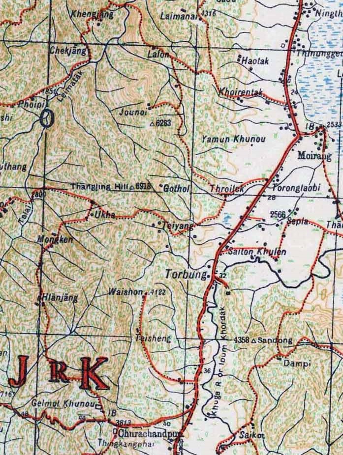
Thangjing Hill (also called Thangching Hill and Thangting Hill), Debanish AchomRow Over Cross And Flag Atop Manipur's "Sacred" Hill, Police Case Filed NDTV News, 6 October 2023. is a mountain peak in the Indian state of Manipur. It is in the Churachandpur district, to the west of Moirang. The north–south-running mountain range on which it sits is also called Thangjing range or Thangjing Hills. The range forms part of the western border of the Imphal Valley. The Thangjing Hill is believed by Manipuris to be the abode of Thangching, the ancestral deity of Moirang. In the Meitei cosmology, the "body" of Manipur is represented with various natural features of the land, including the Thangjing hill as its right leg. The Meiteis of the Moirang region carry out an annual pilgrimage to the top of the hill. Geography The Thangjing Hill is at an elevation of about above the mean sea level. It is part of the western hill range that bounds the Imphal Valley. The entire hill is in the ... [...More Info...] [...Related Items...] OR: [Wikipedia] [Google] [Baidu] |
Churachandpur District
Churachandpur District (Meitei language, Meitei pronunciation: ''/tʃʊraːˌtʃaːnɗpʊr/''), is one of the 16 List of districts of Manipur, districts of the Indian state of Manipur populated mainly by Kuki-Zo people. The name honours former Maharaja Churachand Singh, Sir Churachand Singh of Manipur (princely state), Manipur. The district headquarters is located in the Churachandpur town, which is also locally known by the name Lamka. The Churachandpur district first came into being as the South-West Area hill subdivision of Manipur in 1919. It soon acquired the name "Churachandpur subdivision" based on its headquarters at Songpi, which was also called "Churachandpur". After the independence of India, it remained one of the eight subdivisions of Manipur. A "New Churachandpur" town was built at the present location to serve as its headquarters. In 1969, the subdivision was upgraded to a district, initially called "Manipur South" and later "Churachandpur district". In 2016, the ... [...More Info...] [...Related Items...] OR: [Wikipedia] [Google] [Baidu] |
Songpi
Songpi, at one time called "Churachandpur", is a village in the Churachandpur district, Manipur, India. It served as the headquarters of one of the first hill subdivisions established under the British Raj in the 1920s, which also came to be called the "Churachandpur Subdivision". Later, the Songpi cum "Churachandpur" village served as the headquarters of the Christian missionary organisation, North-East India General Mission (NEIGM). After the British departure, a new headquarters was built at "New Churachandpur" 6 km to the east (which became the presen-day Churachandpur Town), and Songpi reverted to a regular village. The area around the old headquarters is called the Mission Compound and listed in the census as a separate village. Geography Songpi is 6 km west of the Churachandpur Town on the Tipaimukh Road ( National Highway 2). History During the Kuki Rebellion of 1917-1919, the chief of Songpi, Semthong Haokip, refrained from taking part in the rebellio ... [...More Info...] [...Related Items...] OR: [Wikipedia] [Google] [Baidu] |
British Raj
The British Raj ( ; from Hindustani language, Hindustani , 'reign', 'rule' or 'government') was the colonial rule of the British The Crown, Crown on the Indian subcontinent, * * lasting from 1858 to 1947. * * It is also called Crown rule in India, * * * * or direct rule in India. * Quote: "Mill, who was himself employed by the British East India company from the age of seventeen until the British government assumed direct rule over India in 1858." * * The region under British control was commonly called India in contemporaneous usage and included areas directly administered by the United Kingdom of Great Britain and Ireland, United Kingdom, which were collectively called ''Presidencies and provinces of British India, British India'', and areas ruled by indigenous rulers, but under British British paramountcy, paramountcy, called the princely states. The region was sometimes called the Indian Empire, though not officially. As ''India'', it was a founding member of th ... [...More Info...] [...Related Items...] OR: [Wikipedia] [Google] [Baidu] |
Kabui Naga
The Rongmeis (also known as Kabui) are one of the Naga ethnic communities of North-East India. They are recognised as a scheduled tribe (STs) in the Constitution of India. They share similarity with their kindred tribes of Zeme, Liangmai and Inpui, which together are known as Zeliangrong. Some historians and anthropologists have earlier recorded them as Kabui along with Inpui people. Festival The Gaan-Ngai festival (post-harvest festival) is celebrated annually between December and January. It follows the lunar calendar and is celebrated on the 13th day of the Wakching or Gaan Ngai buh. It is celebrated to worship the Supreme God Haipou Tingkao Ragwang. Rebellion During the Colonial period, under the leadership of Haipou Jadonang Malangmei and his successor Rani Gaidinliu Pamei, the Rongmeis along with other Zeliangrong tribes rebelled against British rule in the 1930s. See also *Hill tribes of Northeast India * Tamenglong *Zeliangrong *List of Naga tribes Na ... [...More Info...] [...Related Items...] OR: [Wikipedia] [Google] [Baidu] |
Kangpokpi District
Kangpokpi district ( Meitei pronunciation: /kāng-pōk-pī/) is one of the 16 districts in the Indian state of Manipur. It was created in December 2016 from areas in the Sadar Hills region which were previously part of Senapati District. The district headquarters is located in Kangpokpi. The district was formed from three sub-divisions of Senapati District: Sadar Hills West, Sadar Hills East and Saitu–Gamphazol. History After its merger into the Republic of India, the Manipur state was administered as a single district. It was divided into eight subdivisions, of which the Sadar subdivision (central subdivision) constituted the region around the Imphal city. By 1961, the Sadar subdivision was replaced by two plains subdivisions, Imphal West and Imphal East, while the surrounding hill regions were added to the Mao subdivision in the north to form a combined "Mao and Sadar Hills" subdivision. In 1969, the single district of Manipur was divided into five districts, with Mao ... [...More Info...] [...Related Items...] OR: [Wikipedia] [Google] [Baidu] |
Chiru People
The Naga people, Chiru people are a Naga people, Naga ethnic group, inextricably belonging to a unique ancestral kindred of the REM NAGA family or kinship of five tribes (Aimol, Kharam, Purum, Chiru, Koren) in the context of the Kangleipak Kingdom (Manipur Hills). Despite the lack of linguistic, anthropological, or scholarly details, it is pertinent to note that the larger Rem inclusivity is revered amongst the tribes of ''Ranglong, Ranglong, Hrangkhawl, /Rangkhol Sakisep(Sakachep), Chorai/Chorei, and other Halam tribes of Tripura and Assam'' who rather share 70%-90% of communicable language structures till today. The kindred term "Rem" never applied to any of the Thadou-Zo-Chin tribes in the overall course of history. The term "LU-TU", or head severers/head hunters was completely denounced as a satanic/devilish culture/tradition after the early 20th century evangelization and early Christian leaders succeeded in complete eradication of its usage. Rongmei Naga evangelists ... [...More Info...] [...Related Items...] OR: [Wikipedia] [Google] [Baidu] |
Old Kukis
The Kuki people, or Kuki-Zo people,Rakhi BoseIn Tense Manipur, Sub-Categorisation And 'Creamy Layer' Could Open A Pandora's Box Outlook, 11 September 2024. uoting general secretary of the Committee on Tribal Unity (COTU), Kangpokpi''At present, all tribal communities in Manipur (other than the Nagas) are united and organised under the banner of Kuki-Zo, and we want separate administration for our regions in Kangpokpi, Churachandpur and Tengnoupal.” are an ethnic group in the Northeastern Indian states of Manipur, Nagaland, Assam, Meghalaya, Tripura and Mizoram, as well as the neighbouring countries of Bangladesh and Myanmar. The Kukis form one of the largest hill tribe communities in this region. In Northeast India, they are present in all states except Arunachal Pradesh. The Chin people of Myanmar and the Mizo people of Mizoram are kindred tribes of the Kukis. Collectively, they are termed the Zo people. Some fifty tribes of Kuki peoples in India are recognised as schedu ... [...More Info...] [...Related Items...] OR: [Wikipedia] [Google] [Baidu] |
Koireng People
The Koireng people are one of the ethnic groups inhabiting Manipur in North-East India. They speak the oireng language They are mentioned in the Meitei royal chronicle Cheitharol Kumbaba in the year 1404, one of the oldest tribes to be so mentioned. They have a shared common ancestry, history, cultural traits, folklore and dialects with their kindred people like Aimol and Kom. They use Meitei language as their second language (L2) according to the Ethnologue ''Ethnologue: Languages of the World'' is an annual reference publication in print and online that provides statistics and other information on the living languages of the world. It is the world's most comprehensive catalogue of languages. It w .... References Bibliography * Shakespear, J. (1909) 'The Kuki–Lushai Clans.' ''The Journal of the Royal Anthropological Institute of Great Britain and Ireland.'' Vol. 39 (Jul., 1909), pp. 371–385 * https://web.archive.org/web/20131107225208/http://censusindia.g ... [...More Info...] [...Related Items...] OR: [Wikipedia] [Google] [Baidu] |
Khamba Thoibi
The ancient legend of Khamba and Thoibi () is a classic, as well as one of the epic cycles of incarnations of Meitei mythology and folklore, that is originated from Ancient Moirang kingdom of Ancient Kangleipak (early Manipur). It is referred to as the "national romantic legend of Manipur" by Indian scholar Suniti Kumar Chatterjee. Among the countless retelling editions of the epic story, is '' Khamba Thoibi Sheireng'' () an eight-volume, 39,000-line epic poem composed by Hijam Angangha and published in 1940. It was written in Pena Saisak folk ballad style and has been called the national epic of Manipur. The classic tale of Khamba and Thoibi became an Assamese classic as well, after being translated into Assamese language as ''Khamba Thoibir Sadhukatha'', by Assamese author and anthropologist Rajanikanta Bordoloi (1869-1939). Background According to legend, Keke Moirang was created by the God Thangching. The first King of Moirang was Iwang Fang Fang Ponglenhanba, ... [...More Info...] [...Related Items...] OR: [Wikipedia] [Google] [Baidu] |
Kangleipak
Kangleipak was an ancient, lesser known civilisation, consisting of the modern day Manipur, India which is still known to some residents as Kangleipak, and other neighbouring regions. The Kangla served as the foremost capital city of this realm from the 15th century BCE, up to medieval times. History The Kingdom of Kangleipak (present-day Manipur, India) was an independent monarchy in Northeast India with a rich cultural and political history. Traditionally believed to have been founded in 33 CE by King Nongda Lairen Pakhangba, Kangleipak was ruled by the Meitei kings, who established a distinct administrative system and patronized the indigenous Sanamahism religion. Throughout its history, Kangleipak experienced periods of internal consolidation, external conflicts, and cultural exchanges with neighboring regions, including Burma (Myanmar) and Assam. The kingdom saw a significant transformation during the reign of Garibniwaj (1709–1748), who expanded its territory and in ... [...More Info...] [...Related Items...] OR: [Wikipedia] [Google] [Baidu] |
Eputhou Thangjing
Thangching or Thangjing is a primordial deity in Sanamahism, the indigenous religion of Manipur. He is the ruling deity of the Moirang dynasty. He rules supreme on the banks of the landlocked sea, Loktak lake. He is one of the four cardinal Umang Lais. The guardianship of the south western direction is attributed to Thangjing and the other directions to Koubru (north west), Marjing (north east) and Wangbren (south east). Two of his most prominent pantheons are the Thangching Temple and the Thangching Hill (Thangjing Peak). Origin Thangjing is a deity of pre-Hindu origin. The Moirang Ningthourol Lambuba mentioned that Moirang was the amalgamation of different groups of people with different traditional beliefs. During the reign of King Fang Fang Ponglenhanpa (52 BC- 28 AD), all the diversities were merged into one with God Thangjing as the central figure. When the cult of Thangjing was merged into the Umang Laism, the folk deities associated with God Thangjing began to ... [...More Info...] [...Related Items...] OR: [Wikipedia] [Google] [Baidu] |


