|
Teshio, Hokkaidō
is a town located in Rumoi, Hokkaido, Japan. , the town had an estimated population of 2,642 in 1,444 households, and a population density of 7.5 people per km2. The total area of the town is . Geography Teshio is located in the northernmost part of Rumoi jurisdiction in northern Hokkaido, surrounded by the left bank of the downstream Teshio River. The central town area, where the town hall is located, is at the mouth of the river, and the hamlet of Onobunai is located along Japan National Route 40. Neighbouring municipalities * Hokkaido ** Enbetsu ** Horonobe ** Nakagawa Climate Teshio has a Humid continental climate (Köppen ''Dfb'') characterized by cold summers and cold winters with heavy snowfall. The average annual temperature in Teshio is 6.9 °C. The average annual rainfall is 1176 mm with September as the wettest month. The temperatures are highest on average in August, at around 20.1 °C, and lowest in January, at around -5.2 °C. Demographic ... [...More Info...] [...Related Items...] OR: [Wikipedia] [Google] [Baidu] |
Towns Of Japan
A town (町; ''chō'' or ''machi'') is a Local government, local administrative unit in Japan. It is a local public body along with Prefectures of Japan, prefecture (''ken'' or other equivalents), Cities of Japan, city (''shi''), and Villages of Japan, village (''mura''). Geographically, a town is contained within a Districts of Japan, district. The same word (町; ''machi'' or ''chō'') is also used in names of smaller regions, usually a part of a Wards of Japan, ward in a city. This is a legacy of when smaller towns were formed on the outskirts of a city, only to eventually merge into it. Towns See also * Municipalities of Japan * List of villages in Japan * List of cities in Japan * Japanese addressing system References External links "Large City System of Japan"; graphic shows towns compared with other Japanese city types at p. 1 [PDF 7 of 40 /nowiki>] {{Asia topic, List of towns in Towns in Japan, * ... [...More Info...] [...Related Items...] OR: [Wikipedia] [Google] [Baidu] |
Population Density
Population density (in agriculture: Standing stock (other), standing stock or plant density) is a measurement of population per unit land area. It is mostly applied to humans, but sometimes to other living organisms too. It is a key geographical term.Matt RosenberPopulation Density Geography.about.com. March 2, 2011. Retrieved on December 10, 2011. Biological population densities Population density is population divided by total land area, sometimes including seas and oceans, as appropriate. Low densities may cause an extinction vortex and further reduce fertility. This is called the Allee effect after the scientist who identified it. Examples of the causes of reduced fertility in low population densities are: * Increased problems with locating sexual mates * Increased inbreeding Human densities Population density is the number of people per unit of area, usually transcribed as "per square kilometre" or square mile, and which may include or exclude, for example, ar ... [...More Info...] [...Related Items...] OR: [Wikipedia] [Google] [Baidu] |
Hokuriku Region
The is located in the northwestern part of Honshu, the main island of Japan. It lies along the Sea of Japan and is part of the larger Chūbu region. It is almost equivalent to the former Koshi Province (Japan), Koshi Province and Hokurikudō area in pre-modern Japan. From the Heian period until the Edo period, the region was a core recipient of population, and grew to be proportionately much larger than it is today, despite the rural character; in modern times, its population has remained consistent, with most urban growth in the 20th century instead taking place in Kantō region, Kanto, Nagoya, Chūkyō, and Kansai region, Kansai. The Hokuriku region is also known for traditional culture that originated from elsewhere that has been long lost along the Taiheiyō Belt. The Hokuriku region includes the four prefectures of Ishikawa Prefecture, Ishikawa, Fukui Prefecture, Fukui, Niigata Prefecture, Niigata and Toyama Prefecture, Toyama, although Niigata is sometimes included as an a ... [...More Info...] [...Related Items...] OR: [Wikipedia] [Google] [Baidu] |
Meiji Period
The was an era of Japanese history that extended from October 23, 1868, to July 30, 1912. The Meiji era was the first half of the Empire of Japan, when the Japanese people moved from being an isolated feudal society at risk of colonization by Western powers to the new paradigm of a modern, industrialized nation state and emergent great power, influenced by Western scientific, technological, philosophical, political, legal, and aesthetic ideas. As a result of such wholesale adoption of radically different ideas, the changes to Japan were profound, and affected its social structure, internal politics, economy, military, and foreign relations. The period corresponded to the reign of Emperor Meiji. It was preceded by the Keiō era and was succeeded by the Taishō era, upon the accession of Emperor Taishō. The rapid modernization during the Meiji era was not without its opponents, as the rapid changes to society caused many disaffected traditionalists from the former samu ... [...More Info...] [...Related Items...] OR: [Wikipedia] [Google] [Baidu] |
Edo Period
The , also known as the , is the period between 1600 or 1603 and 1868 in the history of Japan, when the country was under the rule of the Tokugawa shogunate and some 300 regional ''daimyo'', or feudal lords. Emerging from the chaos of the Sengoku period, the Edo period was characterized by prolonged peace and stability, urbanization and economic growth, strict social order, Isolationism, isolationist foreign policies, and popular enjoyment of Japanese art, arts and Culture of Japan, culture. In 1600, Tokugawa Ieyasu prevailed at the Battle of Sekigahara and established hegemony over most of Japan, and in 1603 was given the title ''shogun'' by Emperor Go-Yōzei. Ieyasu resigned two years later in favor of his son Tokugawa Hidetada, Hidetada, but maintained power, and defeated the primary rival to his authority, Toyotomi Hideyori, at the Siege of Osaka in 1615 before his death the next year. Peace generally prevailed from this point on, making samurai largely redundant. Tokugawa sh ... [...More Info...] [...Related Items...] OR: [Wikipedia] [Google] [Baidu] |
Matsumae Domain
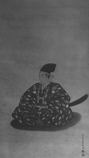
file:Matsumae Nagahiro.jpg, 270px, Matsumae Nagahiro, final daimyo of Matsumae Domain The Matsumae Domain (松前藩), a prominent domain during the Edo period, was situated in Matsumae, Matsumae Island (Ishijima), which is currently known as Matsumae Town, Matsumae District, Hokkaido, Matsumae District, Hokkaido, via Tsugaru District, Mutsu, Tsugaru District, Oshima Province. The clan's leader, also known as the lord of the domain, constructed Matsumae Castle, Matsumae Fukuyama Castle in the same location and henceforth, the clan came to be referred to as the Fukuyama clan. In 1868, the castle was relocated to Tatejo in Assabu-cho, Hiyama-gun, within the territory, and was known as Tatehan during the Meiji era, Meiji period. Initially, the Matsumae clan's jurisdiction was limited to the Wajin territory on the Oshima Peninsula in southwest Hokkaido. However, they gradually expanded their control over the Ezo region, which is now part of Hokkaido, and transformed it into their dom ... [...More Info...] [...Related Items...] OR: [Wikipedia] [Google] [Baidu] |
Ainu People
The Ainu are an Indigenous peoples, indigenous ethnic group who reside in northern Japan and southeastern Russia, including Hokkaido and the Tōhoku region of Honshu, as well as the land surrounding the Sea of Okhotsk, such as Sakhalin, the Kuril Islands, the Kamchatka Peninsula, and the Khabarovsk Krai. They have occupied these areas, known to them as "Ainu Mosir" (), since before the arrival of the modern Yamato people, Yamato and Treaty of Aigun, Russians. These regions are often referred to as and its inhabitants as in historical Japanese texts. Along with the Yamato and Ryukyuan people, Ryukyu ethnic groups, the Ainu people are one of the primary historic ethnic groups of Japan. Official surveys of the known Ainu population in Hokkaido received 11,450 responses in 2023, and the Ainu population in Russia was estimated at 300 in 2021. Unofficial estimates in 2002 placed the total population in Japan at 200,000 or higher, as the near-total Cultural assimilation, assimilatio ... [...More Info...] [...Related Items...] OR: [Wikipedia] [Google] [Baidu] |
Kotan (village)
A kotan (Katakana: コタン) is a traditional settlement of the Ainu people. Introduction Due to the scarcity of primary source materials (as the Ainu did not have a system of writing), all studies on the Ainu kotan (based on Russian, Japanese, and English works) will have different analyzations and opinions, varying largely depending on the researchers and the duration of their work. The word ''kotan'' is often erroneously translated to as a "village"; the term generally applies to all human settlements, regardless of their size. For example, in the Ainu translation of the Bible, Rome and Jerusalem are referred to as ''yerusalem kotan'' and ''roma kotan'', respectively. Description Unlike other hunter gatherers, who did not settle in one place at any given time, the Ainu were highly dependent on fishing, therefore they settled by places that had good fishing (like river estuaries) and built settlements there, though depending on the season the Ainu would move to a new ... [...More Info...] [...Related Items...] OR: [Wikipedia] [Google] [Baidu] |


