|
Tebaga Gap
The Tebaga Gap of southern Tunisia is a low mountain pass located in rough rocky broken country giving entry to the inhabited coastal plain to the north and east from much less hospitable desert dominated terrain in southern and south-western Tunisia. The pass separates the Matmata hills to the east running roughly north to south from the Djebel Tebaga hills, another line of high ground to the west of the gap running east–west. The terrain of the region about the pass was of great tactical importance during the Second World War in 1939–1940 and in 1943.. North and west of this region is the great salt lake known as the Chott el Djerid or Chotts. West of the Matmata Hills, the terrain is dry country, the Jebel Dahar, and then impassable sand of the Grand Erg Oriental. The oasis town of Gabès lies on the coast where the plain meets the route from the Tebaga Gap. North of Gabès, the road to Sfax, an ancient caravan route to Libya and points east, passes between the sea ... [...More Info...] [...Related Items...] OR: [Wikipedia] [Google] [Baidu] |
Oasis
In ecology, an oasis (; ) is a fertile area of a desert or semi-desert environmentBattesti, Vincent (2005) Jardins au désert: Évolution des pratiques et savoirs oasiens: Jérid tunisien. Paris: IRD éditions. . that sustains plant life and provides habitat for animals. Surface water may be present, or water may only be accessible from wells or underground channels created by humans. In geography, an oasis may be a current or past rest stop on a transportation route, or less-than-verdant location that nonetheless provides access to underground water through deep wells created and maintained by humans. The word ''oasis'' came into English from la, oasis, from grc, ὄασις, , which in turn is a direct borrowing fro ... [...More Info...] [...Related Items...] OR: [Wikipedia] [Google] [Baidu] |
Operation Pugilist
The Battle of the Mareth Line or the Battle of Mareth was an attack in the Second World War by the British Eighth Army (General Bernard Montgomery) in Tunisia, against the Mareth Line held by the Italo-German 1st Army (General Giovanni Messe). It was the first big operation by the Eighth Army since the Second Battle of El Alamein months previously. On 19 March 1943, Operation Pugilist, the first British attack, established a bridgehead but a break-out attempt was defeated by Axis counter-attacks. Pugilist established an alternative route of attack and Operation Supercharge II, an outflanking manoeuvre via the Tebaga Gap was planned. Montgomery reinforced the flanking attack, which from 26 to 31 March, forced the 1st Army to retreat to Wadi Akarit, another back in Tunisia. Background Axis retreat from El Alamein The retreat of Panzer Army Africa (known as the / from October 1942) took place from 5 November 1942 to 15 February 1943. On 8 November, Operation Torch began in Morocc ... [...More Info...] [...Related Items...] OR: [Wikipedia] [Google] [Baidu] |
Operation Torch
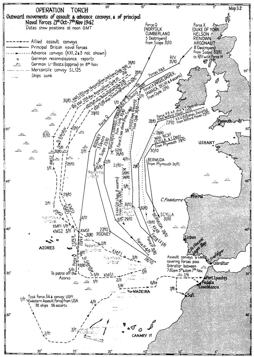
Operation Torch (8 November 1942 – 16 November 1942) was an Allied invasion of French North Africa during the Second World War. Torch was a compromise operation that met the British objective of securing victory in North Africa while allowing American armed forces the opportunity to engage in the fight against Nazi Germany on a limited scale. It was the first mass involvement of US troops in the European–North African Theatre, and saw the first major airborne assault carried out by the United States. While the French colonies were formally aligned with Germany via Vichy France, the loyalties of the population were mixed. Reports indicated that they might support the Allies. American General Dwight D. Eisenhower, supreme commander of the Allied forces in Mediterranean Theater of Operations, planned a three-pronged attack on Casablanca (Western), Oran (Center) and Algiers (Eastern), then a rapid move on Tunis to catch Axis forces (Afrika Korps) in North Africa from the ... [...More Info...] [...Related Items...] OR: [Wikipedia] [Google] [Baidu] |
Tunisia Campaign
The Tunisian campaign (also known as the Battle of Tunisia) was a series of battles that took place in Tunisia during the North African campaign of the Second World War, between Axis and Allied forces from 17 November 1942 to 13 May 1943. The Allies consisted of British Imperial Forces, including a Greek contingent, with American and French corps. The battle opened with initial success by the German and Italian forces but the massive supply interdiction efforts led to the decisive defeat of the Axis. Over 250,000 German and Italian troops were taken as prisoners of war, including most of the Afrika Korps. Background Western Desert The first two years of the war in North Africa were characterized by chronic supply shortages and transport problems. The North African coast has few natural harbors and the British base at Alexandria on the Nile delta was some by road from the main Italian port at Tripoli in Libya. Smaller ports at Benghazi and Tobruk were and west of Alexan ... [...More Info...] [...Related Items...] OR: [Wikipedia] [Google] [Baidu] |
Town
A town is a human settlement. Towns are generally larger than villages and smaller than city, cities, though the criteria to distinguish between them vary considerably in different parts of the world. Origin and use The word "town" shares an origin with the German language, German word , the Dutch language, Dutch word , and the Old Norse . The original Proto-Germanic language, Proto-Germanic word, *''tūnan'', is thought to be an early borrowing from Proto-Celtic language, Proto-Celtic *''dūnom'' (cf. Old Irish , Welsh language, Welsh ). The original sense of the word in both Germanic and Celtic was that of a fortress or an enclosure. Cognates of ''town'' in many modern Germanic languages designate a fence or a hedge. In English and Dutch, the meaning of the word took on the sense of the space which these fences enclosed, and through which a track must run. In England, a town was a small community that could not afford or was not allowed to build walls or other larger fort ... [...More Info...] [...Related Items...] OR: [Wikipedia] [Google] [Baidu] |
Matmata, Tunisia
Matmata ( ar, مطماطة '; Berber: ⵎⴰⵜⵎⴰⵜⴰ) is a small Berber speaking town in southern Tunisia. Some of the local Berber residents live in traditional underground " troglodyte" structures. In 2004 it had a population of 2,116. The structures typical for the village are created by digging a large pit in the ground. Around the perimeter of this pit artificial caves are then dug to be used as rooms, with some homes comprising multiple pits, connected by trench-like passageways. History It was not generally known until 1969 that there were regular settlements in this area besides wandering nomadic tribes. That year, intensive rains that lasted for 22 days inundated the troglodyte homes and caused many of them to collapse. In order to get help from the authorities, a delegation was sent to the community center of the region in the town of Gabès. The visit came as a surprise, but help was provided, and the above-ground settlement of Matmâta was built. Howev ... [...More Info...] [...Related Items...] OR: [Wikipedia] [Google] [Baidu] |
Libya
Libya (; ar, ليبيا, Lībiyā), officially the State of Libya ( ar, دولة ليبيا, Dawlat Lībiyā), is a country in the Maghreb region in North Africa. It is bordered by the Mediterranean Sea to the north, Egypt to the east, Sudan to the southeast, Chad to the south, Niger to the southwest, Algeria to the west, and Tunisia to the northwest. Libya is made of three historical regions: Tripolitania, Fezzan, and Cyrenaica. With an area of almost 700,000 square miles (1.8 million km2), it is the fourth-largest country in Africa and the Arab world, and the 16th-largest in the world. Libya has the 10th-largest proven oil reserves in the world. The largest city and capital, Tripoli, is located in western Libya and contains over three million of Libya's seven million people. Libya has been inhabited by Berbers since the late Bronze Age as descendants from Iberomaurusian and Capsian cultures. In ancient times, the Phoenicians established city-states and tr ... [...More Info...] [...Related Items...] OR: [Wikipedia] [Google] [Baidu] |
Sfax
Sfax (; ar, صفاقس, Ṣafāqis ) is a city in Tunisia, located southeast of Tunis. The city, founded in AD849 on the ruins of Berber Taparura, is the capital of the Sfax Governorate (about 955,421 inhabitants in 2014), and a Mediterranean port. Sfax has a population of 330,440 (census 2014). The main industries are phosphate, olive and nut processing, fishing (largest fishing port in Tunisia) and international trade. The city is the second-most populous after the capital, Tunis. History Carthaginian and Aghlabid eras Present-day Sfax was founded in AD849 on the site of the Berber town of Taparura. The modern city has also grown to cover some other ancient settlements, most notably Thenae in its southern suburb of Thyna. Almohad era By the end of the 10th century, Sfax had become an independent city-state. The city was conquered by Roger II of Sicily in 1148 and occupied until it was liberated in 1156 by the Almohads, and was briefly occupied by European ... [...More Info...] [...Related Items...] OR: [Wikipedia] [Google] [Baidu] |
Gabès
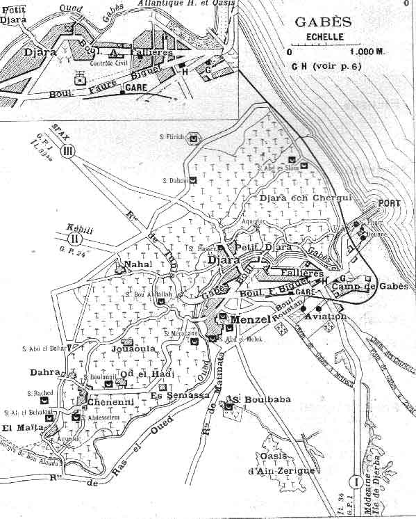
Gabès (, ; ar, قابس, ), also spelled Cabès, Cabes, Kabes, Gabbs and Gaps, is the capital city of the Gabès Governorate in Tunisia. It is located on the coast of the Gulf of Gabès. With a population of 152,921, Gabès is the 6th largest Tunisian city. Gabes is 327 km away from Tunis and 113 km away from Sfax. History Etymology Takapes, the ancient name of Gabès, is a Numidian ( Berber) toponym. Later, the prefix "Ta" (meaning "to" in Berber) was dropped, and the place became known as Kapes. As in Arabic the sound /p/ is unknown, Kapes became known as Kabes, and later known as Gabès. Roman period Gabès is the ancient ''Tacapae'' or ''Tacape'' (Τακάπη in Ancient greek) or ''Tacapes'' of the Roman province of Tripolitania. Strabo refers to this city as an important entrepot of the Lesser Syrtis. Pliny (18.22) remarks that the waters of a copious fountain at Tacape were divided among the cultivators according to a system where each had the use of the water d ... [...More Info...] [...Related Items...] OR: [Wikipedia] [Google] [Baidu] |
Grand Erg Oriental
The Grand Erg Oriental (English: 'Great Eastern Sand Sea') is a large '' erg'' or "field of sand dunes" in the Sahara Desert. Situated for the most part in Saharan lowlands of northeast Algeria, the Grand Erg Oriental covers an area some 600 km wide by 200 km north to south. The erg's northeastern edge spills over into neighbouring Tunisia. Natural phenomena The Grand Erg Oriental is a desert, a natural region receiving very little rainfall. It is the largest ''Erg'' in Algeria, the next in size being the much smaller Grand Erg Occidental ('Western Sand Sea'). The largest erg of the Sahara is probably As-Sahra al-Libiyah, which straddles the inland border of Libya and Egypt. Erg is a Tamachek Berber word, and also a geographic term of art. The Grand Erg Oriental used to be associated with the Wadi Igharghar, a mostly dry and buried river with a sizable network of tributaries which, should it possess any water, would flow north into the erg from the Ahaggar mountain ... [...More Info...] [...Related Items...] OR: [Wikipedia] [Google] [Baidu] |
.jpg)


.jpg)
.jpg)


