|
Tchirozérine
Tchirozerine is a town and urban commune in Niger. As of 2012, the commune's population was 63,503. Economy Nearby Tchirozerine is the Anou Araren mining area. The state company SONICHAR, established in 1975, has produced coal in an open pit mine since 1980. The production, 246,558 tonnes in 2010, is almost entirely used on site in a power plant, operated by the same company, to power the uranium processing plants of Arlit Arlit is an industrial town and capital of the Arlit Department of the Agadez Region of northern-central Niger, built between the Sahara Desert and the eastern edge of the Aïr Mountains. It is 200 kilometers south by road from the bord ... and Akokan and for the main cities of the Agadez region. References Communes of Niger {{Niger-geo-stub ... [...More Info...] [...Related Items...] OR: [Wikipedia] [Google] [Baidu] |
Agadez Region
Agadez Region is one of the seven regions of Niger. At , it covers more than half of Niger's land area, and is the largest region in the country, as well as the list of the largest country subdivisions by area, largest African state subdivision. The capital of the department is Agadez. History The region is a centre for palaeontology, with numerous dinosaur skeletons being found here, including the ''Ouranosaurus nigeriensis''. Cave painting and the remains of ancient human settlements are also located here. Tuareg peoples began migrating to the region from the mid-8th century. From the mid-15th century to the early 20th, much of the region was under the control of the Sultanate of Agadez, except for a period when the area came under the rule of the Songhai Empire in the 1500s. The region suffered with the advent of French colonialism as power shifted away to the southwest; Tuareg disaffection with French rule resulted in the Kaocen revolt in 1916–17. This process continued fol ... [...More Info...] [...Related Items...] OR: [Wikipedia] [Google] [Baidu] |
Tchirozerine Department
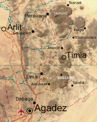
Tchirozerine is a department of the Agadez Region in Niger. Its capital lies at the city of Tchirozerine. As of 2012, the department had a total population of 244,706 people. It is divided administratively into the following communes: *Communes urbaines (urban commune): Tchirozérine, Agadez Agadez ( Air Tamajeq: ⴰⴶⴰⴷⴰⵣ, ''Agadaz''), formerly spelled Agadès, is the fifth largest city in Niger, with a population of 110,497 based on the 2012 census. The capital of the eponymous Agadez Region, the city lies in the Sahara ... (the capital of the Agadez Region) *Communes rurales (rural communes): Dabaga, Tabelot References Departments of Niger Agadez Region {{Niger-geo-stub ... [...More Info...] [...Related Items...] OR: [Wikipedia] [Google] [Baidu] |
Communes Of Niger
The Departments of Niger, Departments of Niger are subdivided into communes. As of 2005, in the seven Regions of Niger, Regions and one Capital Area, there were 36 ''départements'', divided into 265 ''communes'', 122 ''cantons'' and 81 ''groupements''. The latter two categories cover all areas not covered by ''Urban Communes'' (population over 10000) or ''Rural Communes'' (population under 10000), and are governed by the Department, whereas Communes have (since 1999) elected councils and mayors. Additional semi-autonomous sub-divisions include ''Sultanates'', ''Provinces'' and ''Tribes'' (''tribus''). The Nigerien government estimates there are an additional 17000 Villages administered by ''Rural Communes'', while there are over 100 ''Quartiers'' (boroughs or neighborhoods) administered by ''Urban Communes''. The territorial reorganisation of Niger's local administration, known informally as the ''Decentralisation process'', was carried out through a series of laws from 1998 ... [...More Info...] [...Related Items...] OR: [Wikipedia] [Google] [Baidu] |
Regions Of Niger
Niger is divided into seven regions (French: ''régions;'' singular''région)'', each of which is named after its capital. Additionally, the national capital, Niamey, comprises a capital district. Current regions *capital district. Current administrative structure Each of Niger's regions are subdivided into departments and communes. As of 2005, there were 36 ''départements'', divided into 265 communes, 122 cantons and 81 ''groupements''. The latter two categories cover all areas not covered by urban communes (population over 10000) or rural communes (total population 13 million), and are governed by the department, whereas communes have had elected councils and mayors since 1999. Additional semi-autonomous subdivisions include sultanates, provinces and tributaries (''tribus''). The Nigerien government estimates there are an additional 17000 villages administered by rural communes, while there are a number of ''quartiers'' (boroughs or neighborhoods) administered by urban ... [...More Info...] [...Related Items...] OR: [Wikipedia] [Google] [Baidu] |
Departments Of Niger
The regions of Niger are subdivided into 63 Department (country subdivision), departments (). Before the devolution program on 1999–2005, these departments were styled arrondissements. Confusingly, the next level up (regions) had, before 2002-2005 been styled departments. Prior to a revision in 2011, there had been 36 departments. Until 2010, arrondissements remained a proposed subdivision of departments, though none were used. The decentralisation process, begun in the 1995-1999 period replaced appointed Prefects at Departmental or Arrondissement level with elected councils, first elected in 1999. These were the first local elections held in the history of Niger. Officials elected at Communes of Niger, commune level are then selected as representatives at Departmental, regional, and National level councils and administration. The Ministry of Decentralisation was created to oversee this task, and to create a national consultative council of local officials. On 1 August 2 ... [...More Info...] [...Related Items...] OR: [Wikipedia] [Google] [Baidu] |
West Africa Time
West Africa Time, or WAT, is a time zone used in west-central Africa. West Africa Time is one hour ahead of Coordinated Universal Time ( UTC+01:00), which aligns it with Central European Time (CET) during winter, and Western European Summer Time (WEST) / British Summer Time (BST) during summer. As most of this time zone is in the tropical region, there is little change in day length throughout the year and therefore daylight saving time is not observed. West Africa Time is the time zone for the following countries: * (as Central European Time) * * * * * * (western provinces) * * * (as Central European Time) * * * * (as Central European Time) * Countries west of Benin (except Morocco and Western Sahara) are in the UTC+00:00 time zone. See also * Central European Time, an equivalent time zone covering most European countries during winter, also at UTC+01:00 * Western European Summer Time, an equivalent time zone covering western European countries during daylight ... [...More Info...] [...Related Items...] OR: [Wikipedia] [Google] [Baidu] |
Niger
Niger, officially the Republic of the Niger, is a landlocked country in West Africa. It is a unitary state Geography of Niger#Political geography, bordered by Libya to the Libya–Niger border, north-east, Chad to the Chad–Niger border, east, Nigeria to the Niger–Nigeria border, south, Benin and Burkina Faso to the Benin-Niger border, south-west, Mali to the Mali–Niger border, west, and Algeria to the Algeria–Niger border, north-west. It covers a land area of almost , making it the largest landlocked country in West Africa and the second-largest landlocked nation in Africa behind Chad. Over 80% of its land area lies in the Sahara. Its Islam in Niger, predominantly Muslim population of about million lives mostly in clusters in the south and west of the country. The capital Niamey is located in Niger's south-west corner along the namesake Niger River. Following the spread of Islam to the region, Niger was on the fringes of some states, including the Kanem–Bornu Empire ... [...More Info...] [...Related Items...] OR: [Wikipedia] [Google] [Baidu] |
Institut National De La Statistique Du Niger
The ''Institut National de la Statistique du Niger'' (INS-Niger) is a national institute of Niger, which is dedicated to collecting data in the country. It is responsible for compiling data in the country and obtaining census data. It collects data on demographics, population, climatology, transport, industry, electricity, education and employment etc. References External linksOfficial siteUnited Nations Statistical Agency information on the INSN Niger Niger, officially the Republic of the Niger, is a landlocked country in West Africa. It is a unitary state Geography of Niger#Political geography, bordered by Libya to the Libya–Niger border, north-east, Chad to the Chad–Niger border, east ... Government of Niger {{niger-stub ... [...More Info...] [...Related Items...] OR: [Wikipedia] [Google] [Baidu] |
Arlit
Arlit is an industrial town and capital of the Arlit Department of the Agadez Region of northern-central Niger, built between the Sahara Desert and the eastern edge of the Aïr Mountains. It is 200 kilometers south by road from the border with Algeria. As of 2012, the commune had a total population of 79,725 people. Uranium industry Founded in 1969 following the discovery of uranium, it has grown around the mining industry, developed by the French government. Two large uranium mines, at Arlit and nearby Akouta, are exploited by open top strip mining. One open-pit mine was built in 1971 by the National Mining Company of Niger, SOMAIR. The second open-pit mine, as well as a third underground mine, was built by the French Compagnie Minière d'Akouta (or COMINAK). All the ore from both is now processed and transported by a French company Orano Cycle, a holding of the Orano group, itself a state-owned operation of the French ''Commissariat à l'énergie atomique'' ... [...More Info...] [...Related Items...] OR: [Wikipedia] [Google] [Baidu] |
Akokan, Niger
Akokan is a mining town in the Arlit Department of the Agadez Region of northern-central Niger. It is located about southwest of Arlit in the Sahara Desert, and roughly north of Agadez. It is considered to be Niger's "second uranium town". SOMAIR and COMINAK (Compagnie minière d'Akokan), run by Areva and the Nigerien state, operate uranium mines in the vicinity of the towns of Akokan and Arlit. In the maps of the area, Akokan is classified under "Mine - Agadez-Niger". The Tuareg and Toubou people are local to the area. History The Akokan deposit was initially prospected by a France-Japan-Niger tripartite affiliation in the early 1970s. In 1975, underground mining at Akokan was estimated to require over $100 million in investment. Today over 100,000 people live in Akokan and Arlit. Greenpeace has expressed concerns over the high radiation levels found on the streets of Akokan. Afasto, south of Akokan, was the site of newly discovered uranium reserves in 2001. The operation ... [...More Info...] [...Related Items...] OR: [Wikipedia] [Google] [Baidu] |

