|
Tang-e Gharu
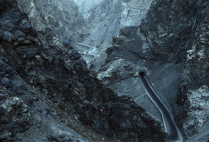
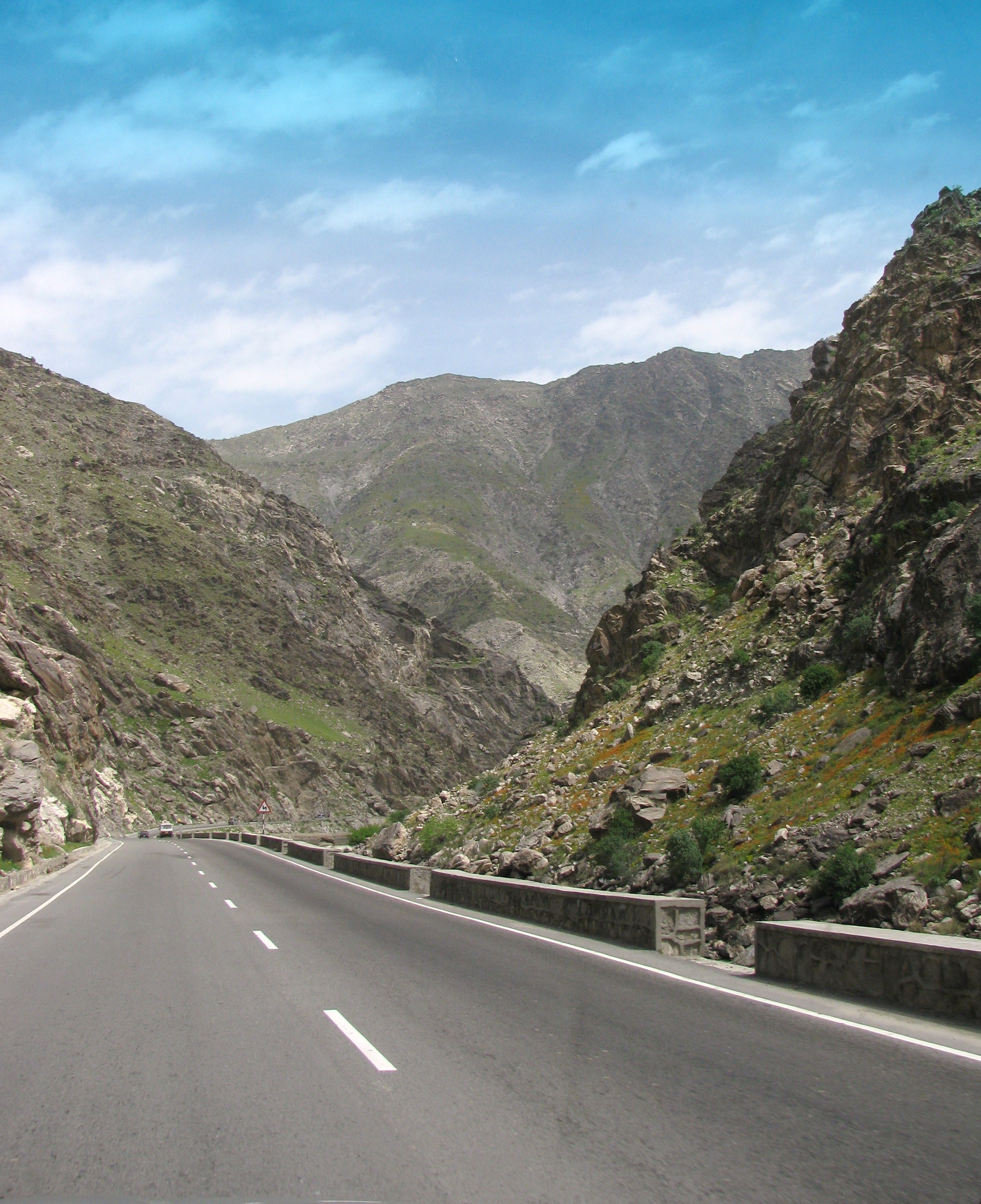
Tang-e Gharu, also known as Tang-e Gharo (Pashto: تنگ غارو), is a gorge and a mountain pass in the Hindu Kush mountain range of Kabul Province, Afghanistan. The Kabul River passes through the gorge, flowing eastward. The Kabul–Jalalabad Road runs through the gorge, parallel to the river. Construction on the road began in the 1940s and was completed in the 1960s, replacing the ancient Lataband Pass in the Karkacha hills connecting Kabul and Jalalabad to Pakistan. Both the pass and the road are considered to be of major strategic importance, as they provide Afghanistan a connection to Pakistan and Russia. Due to heavy usage during recent conflicts in Afghanistan and frequent traffic accidents, the pass and the surrounding areas have become heavily damaged and periodically closed off. Geology The cliffs of Tang-e Gharu gorge are a blue-grey limestone, which was formed some 250 million years ago. However, the gorge itself is only about 2 million years old and was formed as ... [...More Info...] [...Related Items...] OR: [Wikipedia] [Google] [Baidu] |
KABUL GORGE - AFGHANISTAN
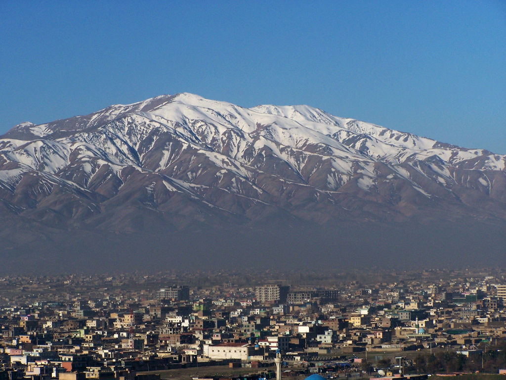
Kabul is the capital and largest city of Afghanistan. Located in the eastern half of the country, it is also a municipality, forming part of the Kabul Province. The city is divided for administration into 22 municipal districts. A 2025 estimate puts the city's population at 7.175 million. In contemporary times, Kabul has served as Afghanistan's political, cultural and economical center. Rapid urbanisation has made it the country's primate city and one of the largest cities in the world. The modern-day city of Kabul is located high in a narrow valley in the Hindu Kush mountain range, and is bounded by the Kabul River. At an elevation of , it is one of the highest capital cities in the world. The center of the city contains its old neighborhoods, including the areas of Khashti Bridge, Khabgah, Kahforoshi, Saraji, Chandavel, Shorbazar, Deh-Afghanan and Ghaderdiwane. Kabul is said to be over 3,500 years old, and was mentioned at the time of the Achaemenid Persian Empire. Located ... [...More Info...] [...Related Items...] OR: [Wikipedia] [Google] [Baidu] |
Pashto
Pashto ( , ; , ) is an eastern Iranian language in the Indo-European language family, natively spoken in northwestern Pakistan and southern and eastern Afghanistan. It has official status in Afghanistan and the Pakistani province of Khyber Pakhtunkhwa. It is known in historical Persian literature as Afghani (). Spoken as a native language mostly by ethnic Pashtuns, it is one of the two official languages of Afghanistan alongside Dari, Constitution of Afghanistan �''Chapter 1 The State, Article 16 (Languages) and Article 20 (Anthem)''/ref> and it is the second-largest provincial language of Pakistan, spoken mainly in Khyber Pakhtunkhwa and the northern districts of Balochistan. Likewise, it is the primary language of the Pashtun diaspora around the world. The total number of Pashto-speakers is at least 40 million, (40 million) although some estimates place it as high as 60 million. Pashto is "one of the primary markers of ethnic identity" amongst Pashtuns. Geograph ... [...More Info...] [...Related Items...] OR: [Wikipedia] [Google] [Baidu] |
Hindu Kush
The Hindu Kush is an mountain range in Central Asia, Central and South Asia to the west of the Himalayas. It stretches from central and eastern Afghanistan into northwestern Pakistan and far southeastern Tajikistan. The range forms the western section of the ''Hindu Kush Himalayan Region'' (''HKH''); to the north, near its northeastern end, the Hindu Kush buttresses the Pamir Mountains near the point where the borders of China, Pakistan and Afghanistan meet, after which it runs southwest through Pakistan and into Afghanistan near their border. The eastern end of the Hindu Kush in the north merges with the Karakoram Range. Towards its southern end, it connects with the White Mountains, Afghanistan, White Mountains near the Kabul River. It divides the valley of the Amu Darya (the ancient ''Oxus'') to the north from the Indus River valley to the south. The range has numerous high snow-capped peaks, with the highest point being Tirich Mir or Terichmir at in the Chitral District ... [...More Info...] [...Related Items...] OR: [Wikipedia] [Google] [Baidu] |
Kabul Province
Kabul (Dari/Pashto: ), situated in the east of the country, is one of the thirty-four provinces of Afghanistan. The capital of the province is Kabul city, which is Afghanistan's capital and largest city. The population of the Kabul Province is over 5.5 million people as of 2022, of which over 85 percent live in urban areas. The current governor of the province is Mohammad Aman Obaid. It borders the provinces of Parwan to the north, Kapisa to the north-east, Laghman to the east, Nangarhar to the south-east, Logar to the south, and Wardak to the west. Geography Kabul is located between Latitude 34-31' North and Longitude 69-12' East at an altitude of 1800 m (6000 feet) above sea level, which makes it one of the world's highest capital cities. Kabul is strategically situated in a valley surrounded by high mountains at crossroads of north-south and east-west trade routes. One million years ago the Kabul region was surrounded from south-east between Lowgar and Paghm ... [...More Info...] [...Related Items...] OR: [Wikipedia] [Google] [Baidu] |
Afghanistan
Afghanistan, officially the Islamic Emirate of Afghanistan, is a landlocked country located at the crossroads of Central Asia and South Asia. It is bordered by Pakistan to the Durand Line, east and south, Iran to the Afghanistan–Iran border, west, Turkmenistan to the Afghanistan–Turkmenistan border, northwest, Uzbekistan to the Afghanistan–Uzbekistan border, north, Tajikistan to the Afghanistan–Tajikistan border, northeast, and China to the Afghanistan–China border, northeast and east. Occupying of land, the country is predominantly mountainous with plains Afghan Turkestan, in the north and Sistan Basin, the southwest, which are separated by the Hindu Kush mountain range. Kabul is the country's capital and largest city. Demographics of Afghanistan, Afghanistan's population is estimated to be between 36 and 50 million. Ancient history of Afghanistan, Human habitation in Afghanistan dates to the Middle Paleolithic era. Popularly referred to as the graveyard of empire ... [...More Info...] [...Related Items...] OR: [Wikipedia] [Google] [Baidu] |
Kabul River
The Kabul River (; ), the classical Cophen , is a river that emerges in the Sanglakh Range of the Hindu Kush mountains in the northeastern part of Maidan Wardak Province, Afghanistan. It is separated from the watershed of the Helmand River by the Unai Pass. The Kabul River empties into the Indus River near Attock, Pakistan. It is the main river in eastern Afghanistan and the Khyber Pakhtunkhwa province of Pakistan. Course The Kabul River, which measures long, rises in the Sanglākh Range at Sar Čašma, located at an elevation of 14,000 feet above sea level in the Kōh-e Bābā mountains northwest of Kabul. It passes through the cities of Kabul and Jalalabad in Afghanistan. Its large drainage basin covers the eastern provinces of Nangarhār, Kunar, Laghmān, Lōgar, Kabul, Kāpisā, Parwān, Panjshēr, and Bāmyān before it flows into Khyber Pakhtunkhwa in Pakistan some north of the Durand Line border crossing at Torkham. In Khyber Pakhtunkhwa, the river passes ... [...More Info...] [...Related Items...] OR: [Wikipedia] [Google] [Baidu] |
Kabul–Jalalabad Road
The Kabul–Jalalabad Road, also known as National Highway 08 (NH08), is a highway between the Afghan cities of Kabul (the national capital) and Jalalabad, the largest city in eastern Afghanistan and capital of Nangarhar Province. A portion of the road runs through the Tang-e Gharu gorge, through which the Kabul River also flows. The road is about long and travels upwards from an elevation of 575 meters in Jalalabad to 1,790 meters in Kabul. Because of the many traffic accidents, the road between Jalalabad and Kabul is considered one of the most dangerous in the world. It consists of narrow roads with sharp turns past high cliffs and a valley of the Kabul River below, with which it runs parallel. It is a large part of the Afghan leg of the Grand Trunk Road. Parts of the road follow the route of the British Army The British Army is the principal Army, land warfare force of the United Kingdom. the British Army comprises 73,847 regular full-time personnel, 4,127 Brigad ... [...More Info...] [...Related Items...] OR: [Wikipedia] [Google] [Baidu] |
Lataband Pass
The Lataband Pass or Kotal-e Latah Band, in pashto کوتل لته بند, (elevation: ) is a mountain pass connecting Kabul and Jalalabad on the way to Pakistan in the Karkacha hills between Seh Baba and Butkhak in the Hindukush Range. The name, Lataband, means 'Mountain of Rags' as there was an old belief that people who hung bits of clothing on the bushes along the way, had their wishes granted. Description The Lataband Pass is a difficult and dangerous pass which was on the only road suitable for carriages or motor vehicles between Kabul and Jalalabad until the longer, but less precipitous route via the Khord Kabul was used by the Mughuls in the 16th century. An integral part of the ancient Silk Road, it was still in use until 1960, when the route via Tang-e Gharu route was finally completed and paved. This new road reduced travel time between Kabul and the Pakistan border from two days to only a few hours. It was for many centuries an important link on the trade route betwe ... [...More Info...] [...Related Items...] OR: [Wikipedia] [Google] [Baidu] |
Kabul
Kabul is the capital and largest city of Afghanistan. Located in the eastern half of the country, it is also a municipality, forming part of the Kabul Province. The city is divided for administration into #Districts, 22 municipal districts. A 2025 estimate puts the city's population at 7.175 million. In contemporary times, Kabul has served as Afghanistan's political, cultural and economical center. Rapid urbanisation has made it the country's primate city and one of the largest cities in the world. The modern-day city of Kabul is located high in a narrow valley in the Hindu Kush mountain range, and is bounded by the Kabul River. At an elevation of , it is one of the List of capital cities by elevation, highest capital cities in the world. The center of the city contains its old neighborhoods, including the areas of Khashti Bridge, Khabgah, Kahforoshi, Saraji, Chandavel, Shorbazar, Deh-Afghanan and Ghaderdiwane. Kabul is said to be over 3,500 years old, and was mentioned at the ... [...More Info...] [...Related Items...] OR: [Wikipedia] [Google] [Baidu] |
Jalalabad
Jalalabad (; Help:IPA/Persian, [d͡ʒä.lɑː.lɑː.bɑːd̪]) is the list of cities in Afghanistan, fifth-largest city of Afghanistan. It has a population of about 200,331, and serves as the capital of Nangarhar Province in the eastern part of the country, about from the capital Kabul. Jalalabad is located at the junction of the Kabul River and the Kunar River in a plateau to the south of the Hindu Kush mountains. It is linked by the Kabul-Jalalabad Road to the west and Peshawar in Khyber Pakhtunkhwa, Pakistan, to the east through Torkham border crossing, Torkham and the Khyber Pass. Jalalabad is a leading center of social and trade activity because of its proximity with the Torkham border checkpoint and border crossing, away. Major industries include papermaking, as well as agricultural products including oranges, lemon, rice, and sugarcane, helped by its warm climate. It hosts Afghanistan's second largest educational institute, Nangarhar University. For centuries the city ... [...More Info...] [...Related Items...] OR: [Wikipedia] [Google] [Baidu] |
Pakistan
Pakistan, officially the Islamic Republic of Pakistan, is a country in South Asia. It is the List of countries and dependencies by population, fifth-most populous country, with a population of over 241.5 million, having the Islam by country#Countries, second-largest Muslim population as of 2023. Islamabad is the nation's capital, while Karachi is List of cities in Pakistan by population, its largest city and financial centre. Pakistan is the List of countries and dependencies by area, 33rd-largest country by area. Bounded by the Arabian Sea on the south, the Gulf of Oman on the southwest, and the Sir Creek on the southeast, it shares land borders with India to the east; Afghanistan to the west; Iran to the southwest; and China to the northeast. It shares a maritime border with Oman in the Gulf of Oman, and is separated from Tajikistan in the northwest by Afghanistan's narrow Wakhan Corridor. Pakistan is the site of History of Pakistan, several ancient cultures, including the ... [...More Info...] [...Related Items...] OR: [Wikipedia] [Google] [Baidu] |
Russia
Russia, or the Russian Federation, is a country spanning Eastern Europe and North Asia. It is the list of countries and dependencies by area, largest country in the world, and extends across Time in Russia, eleven time zones, sharing Borders of Russia, land borders with fourteen countries. Russia is the List of European countries by population, most populous country in Europe and the List of countries and dependencies by population, ninth-most populous country in the world. It is a Urbanization by sovereign state, highly urbanised country, with sixteen of its urban areas having more than 1 million inhabitants. Moscow, the List of metropolitan areas in Europe, most populous metropolitan area in Europe, is the capital and List of cities and towns in Russia by population, largest city of Russia, while Saint Petersburg is its second-largest city and Society and culture in Saint Petersburg, cultural centre. Human settlement on the territory of modern Russia dates back to the ... [...More Info...] [...Related Items...] OR: [Wikipedia] [Google] [Baidu] |


