|
Sirikwa
The Sirikwa culture was the predominant Kenyan hinterland culture of the Pastoral Iron Age, c.2000 BP. Seen to have developed out of the Elmenteitan culture of the East African Pastoral Neolithic c.3300-1200 BP, it was followed in much of its area by the Kalenjin, Maa, western and central Kenyan communities of the 18th and 19th centuries. The archaeological evidence indicates that from about AD 1200, the Central Rift and Western Highlands of Kenya were relatively densely inhabited by a group (or groups) of people who practiced both cereal cultivation and pastoralism. They made occasional use of metals and created distinctive roulette-decorated pottery. These people are principally known from their characteristic settlement sites, commonly known as 'Sirikwa holes or hollows'. These comprise a shallow depression, sometimes reinforced at the edges by stone revetments, around which habitation structures were built. There are a number of indicators that the central depression was ... [...More Info...] [...Related Items...] OR: [Wikipedia] [Google] [Baidu] |
Hyrax Hill
Hyrax Hill is a prehistoric site near Nakuru in the Rift Valley province of Kenya. It is a rocky spur roughly half a kilometer in length, with an elevation of 1,900 meters above sea level at its summit. The site was first discovered in 1926 by Louis Leakey during excavations at the nearby Nakuru Burial Site, and Mary Leakey conducted the first major excavations between 1937 and 1938. There are two distinct areas of occupation at Hyrax Hill: one which was occupied during the Pastoral Neolithic and late Iron Age, and one which was occupied by the Sirikwa earlier in the Iron Age. Hyrax Hill is named after the hyrax, a small mammal that lives in rocky areas. Hyraxes were once common in the rocky crevasses of Hyrax Hill, but their numbers have dropped in recent years due to the rapid urbanization of the surrounding area. Hyrax Hill is the location of Hyrax Hill Prehistoric Site and Museum. History of excavation Louis Leakey discovered the remains of prehistoric settlements at Hyra ... [...More Info...] [...Related Items...] OR: [Wikipedia] [Google] [Baidu] |
Sirikwa Holes
Sirikwa holes are saucer-shaped hollows found on hillsides in the western highlands of Kenya and in the elevated stretch of the central Rift Valley around Nakuru. These hollows, each having a diameter of 10–20 metres and an average depth of 2.4 metres, occur in groups, sometimes numbering fewer than ten and at times more than a hundred. Archaeologists believe that construction of these features may have begun in the Iron Age. Etymology Some accounts credit Mary Leakey with having introduced the term "Sirkiwa holes' following excavations at Hyrax Hill between 1937 and 1938. An account in the introduction to Hollis' book on the Nandi, published in 1909, indicates that the term Sirikwa was already in use: An origin narrative from the Sengwer gives an earlier origin of the name: It is thus likely that Sirikwa was the name of one of the two major groupings within the Sengwer of the Sirikwa era, and correctly passed on to Thompson from his Okiek guide as the descriptor of the na ... [...More Info...] [...Related Items...] OR: [Wikipedia] [Google] [Baidu] |
Kerio Valley
Kerio Valley lies between the Tugen Hills and the Elgeyo Escarpment in Kenya. It sits at an elevation of 1,000 meters in the Great Rift Valley, Kenya, Great Rift Valley. Geography The isolated Kerio Valley is situated in a narrow, long strip that is approximately 80 km by 10 km wide at its broadest, through which the Kerio River flows. deep, the valley lies between the Cherangani Hills and the Tugen Hills The Tugen Hills (also known as ''Saimo'') are a series of hills in Baringo County, Kenya. They are located in the central-western portion of Kenya. The Tugen Hills represent one of the few areas in Africa preserving a succession of deposits from .... The Elgeyo Escarpment rises more than above it in places. It has semi-tropical vegetation on the slopes, while the floor of the valley is covered by dry thorn bush. The most comfortable time of the year is in July and August, when the rains have ended and the temperatures are not excessive. The Kerio Valley National ... [...More Info...] [...Related Items...] OR: [Wikipedia] [Google] [Baidu] |
Hyrax Hill Prehistoric Site And Museum
The Hyrax Hill site was proclaimed a national monument in 1945 and opened to the public in 1965. This was as a result of startling discoveries of relics by Mrs. Selfe and subsequent archaeological excavations that were carried out by Dr. Mary Leakey in 1938 that revealed substantial findings in different areas of the site and levels of occupations. The late Mrs. Selfe was the owner of the property. The renovation of archaeology exhibit was made possible through the kind sponsorship of Kenya Museum Society and consultation of British Institute in Eastern Africa in collaboration with the National Museums of Kenya. The hill comprises particular importance due to the fact that it encompasses several phases of occupation; it also has a long history of archaeological investigation, which began in 1937 with Mary Leakey. History of excavations In 1937 Dr. Mary Leakey excavated Site I, and she discovered evidence of late Iron Age habitation consisting of a series of rough stone enclo ... [...More Info...] [...Related Items...] OR: [Wikipedia] [Google] [Baidu] |
Sengwer People
The Sengwer people (also known as Cherang'any and previously as Sekker, Siger, Sigerai, Segelai, Senguer, Senguel and Jangwel) are an indigenous community who primarily live in the Embobut forest in the western highlands of Kenya and in scattered pockets across Trans Nzoia, West Pokot and Elgeyo-Marakwet counties. The Sengwer are sometimes portrayed as a component of the Marakwet people but are a distinct ethnic grouping. The Sengwer people are currently a marginalized community and face significant threats to their identity and ancestral lands. International and human rights organizations including the United Nations, Amnesty International and the Kenya Human Rights Commission recognize the Sengwer as indigenous peoples whose claim to the area goes back hundreds of years and have repeatedly raised concerns about human rights violations against them. History Pre-19th century Etymology Following his Juba expedition, MacDonald (1899) noted of the 'Senguer' who previously 'dw ... [...More Info...] [...Related Items...] OR: [Wikipedia] [Google] [Baidu] |
Great Rift Valley
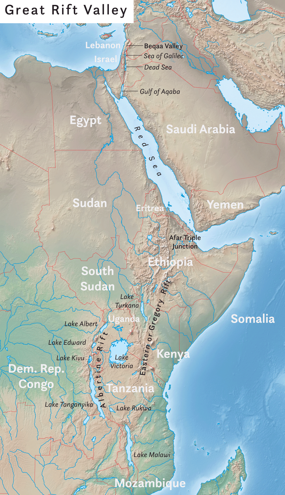
The Great Rift Valley is a series of contiguous geographic trenches, approximately in total length, that runs from Lebanon in Asia to Mozambique in Southeast Africa. While the name continues in some usages, it is rarely used in geology as it is considered an imprecise merging of separate though related rift and fault systems. This valley extends northward for 5,950 km through the eastern part of Africa, through the Red Sea, and into Western Asia. Several deep, elongated lakes, called ribbon lakes, exist on the floor of this rift valley: Lakes Malawi, Rudolf and Tanganyika are examples of such lakes. The region has a unique ecosystem and contains a number of Africa's wildlife parks. The term Great Rift Valley is most often used to refer to the valley of the East African Rift, the divergent plate boundary which extends from the Afar Triple Junction southward through eastern Africa, and is in the process of splitting the African Plate into two new and separate plates. Geolo ... [...More Info...] [...Related Items...] OR: [Wikipedia] [Google] [Baidu] |
Mount Elgon
Mount Elgon is an extinct shield volcano on the border of Uganda and Kenya, north of Kisumu and west of Kitale. The mountain's highest point, named "Wagagai", is located entirely within Uganda."Mount Elgon, Uganda" Peakbagger.com. Retrieved 11 January 2012 Although there is no verifiable evidence of its earliest volcanic activity, geologists estimate that Mount Elgon is at least 24 million years old, making it the oldest extinct volcano in . The mountain's name originates from its Maasai name, Elgonyi. Physical features Mount Elgon ...[...More Info...] [...Related Items...] OR: [Wikipedia] [Google] [Baidu] |
Rongai
Rongai is a town in Nakuru County, Kenya. It lies 30 km west of Nakuru, along the A104 Road and the railway line between Nakuru and Uganda. It is about 10 kilometres north of Elburgon and 15 kilometres east of Molo.The Rough Guide Map - Kenya The town lies 1912 m (6272 ft) above sea level and has a population of 20878. Rongai is part of the Rongai Constituency. Transport It is served by a station on the national railway system. See also * Railway stations in Kenya Railway stations in Kenya include: Maps * UN Map * UNHCR Atlas Map * Prondis Map * Railway Gazette International June 2012, p31 * KRC Map Towns served by metre gauge railways * Mombasa - ocean port * Changamwe * Miritini * Mazeras * Mar ... References External links * Margiti The marketplac {{Kenya-geo-stub Nakuru County ... [...More Info...] [...Related Items...] OR: [Wikipedia] [Google] [Baidu] |
Moiben
Moiben is a settlement in Moiben Constituency, of Uasin Gishu County of Kenya's former Rift Valley Province Rift Valley Province ( sw, Mkoa wa Bonde la Ufa) of Kenya, bordering Uganda, was one of Kenya's eight provinces, before the Kenyan general election, 2013. Rift Valley Province was the largest and one of the most economically important provinces i .... References Populated places in Uasin Gishu County {{RiftValleyKE-geo-stub ... [...More Info...] [...Related Items...] OR: [Wikipedia] [Google] [Baidu] |
Lake Turkana
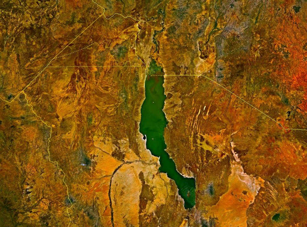
Lake Turkana (), formerly known as Lake Rudolf, is a lake in the Kenyan Rift Valley, in northern Kenya, with its far northern end crossing into Ethiopia. It is the world's largest permanent desert lake and the world's largest alkaline lake. By volume it is the world's fourth-largest salt lake after the Caspian Sea, Issyk-Kul, and Lake Van (passing the shrinking South Aral Sea), and among all lakes it ranks 24th. Lake Turkana is now threatened by the construction of Gilgel Gibe III Dam in Ethiopia due to the damming of the Omo river which supplies most of the lake's water. Although the lake commonly has been —and to some degree still is— used for drinking water, its salinity (slightly brackish) and very high levels of fluoride (much higher than in fluoridated water) generally make it unsuitable, and it has also been a source of diseases spread by contaminated water. Increasingly, communities on the lake's shores rely on underground springs for drinking water. The sam ... [...More Info...] [...Related Items...] OR: [Wikipedia] [Google] [Baidu] |


