|
Swainsona Pterostylis
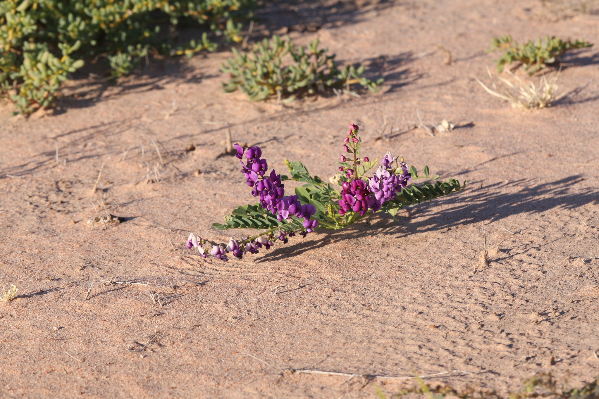
''Swainsona pterostylis'' is a species of flowering plant in the family Fabaceae and is endemic to northern parts of Western Australia. It is a low-growing or prostrate perennial herb, with imparipinnate leaves with mostly 11 to 19 broadly elliptic leaflets, and racemes of 5 to more than 30 purple or violet flowers. Description ''Swainsona pterostylis'' is low-growing or prostrate perennial herb, that typically grows to a height of up to about high, and usually has 3 hairy stems. Its leaves are imparipinnate, mostly long on a petiole, with mostly 11 to 19, broadly elliptic to narrowly egg-shaped with the narrower end towards the base, the side leaflets long and wide. There is a stipule long at the base of the petiole. The flowers are arranged in racemes long with 5 to more than 30 flowers on a peduncle about wide, each flower long on a pedicel long. The sepals are joined at the base, forming a tube about long, the sepal lobes equal to or about as long as the tube. The ... [...More Info...] [...Related Items...] OR: [Wikipedia] [Google] [Baidu] |
Cape Range National Park
Cape Range National Park is a national park in the Gascoyne region of Western Australia, north of Perth. The park occupies the western side of the North West Cape peninsula over an area of . The nearest town is Exmouth, and directly off the coast is the Ningaloo Reef. The area resulted from a gradual uplifting from the sea floor followed by fluctuating sea levels, wind and water erosion that have slowly eroded the range and plain leaving behind a range of rugged limestone, deep canyons, and pristine beaches. There is also an eponymous locality of the Shire of Exmouth, but the boundaries of the national park and the locality are not identical. Overview The Cape is the only elevated plateau composed of limestone on the North West Coast. The range has plateaus to an elevation of and forms the backbone of the peninsula which extends as far as North West Cape. Yardie Creek, a spectacular gorge where the water is trapped by a sandbar, is located within the park. Over 700 ca ... [...More Info...] [...Related Items...] OR: [Wikipedia] [Google] [Baidu] |
Augustin Pyramus De Candolle
Augustin Pyramus (or Pyrame) de Candolle (, , ; 4 February 17789 September 1841) was a Swiss people, Swiss botany, botanist. René Louiche Desfontaines launched de Candolle's botanical career by recommending him at a herbarium. Within a couple of years de Candolle had established a new genus, and he went on to document hundreds of plant families and create a new natural plant classification system. Although de Candolle's main focus was botany, he also contributed to related fields such as phytogeography, agronomy, paleontology, medical botany, and economic botany. De Candolle originated the idea of "Nature's war", which influenced Charles Darwin and the principle of natural selection. De Candolle recognized that multiple species may develop similar characteristics that did not appear in a common evolutionary ancestor; a phenomenon now known as convergent evolution. During his work with plants, de Candolle noticed that plant leaf movements follow a near-24-hour cycle in constant ... [...More Info...] [...Related Items...] OR: [Wikipedia] [Google] [Baidu] |
Pilbara
The Pilbara () is a large, dry, sparsely populated regions of Western Australia, region in the north of Western Australia. It is known for its Indigenous Australians, Aboriginal people; wealth disparity; its ancient landscapes; the prevailing red earth; and its vast mineral deposits, in particular iron ore. It is also a global biodiversity hotspot for subterranean fauna. Definitions of the Pilbara region At least two important but differing definitions of "the Pilbara" region exist. Administratively it is one of the nine regions of Western Australia defined by the ''Regional Development Commissions Act 1993''; the term also refers to the Pilbara shrublands bioregion (which differs in extent) under the Interim Biogeographic Regionalisation for Australia (IBRA). Geography The Pilbara region, as defined by the Regional Development Commissions Act 1993 and administered for economic development purposes by the Pilbara Development Commission, has an estimated population of 61,68 ... [...More Info...] [...Related Items...] OR: [Wikipedia] [Google] [Baidu] |
Murchison Bioregion
The Murchison is a loosely defined area of Western Australia located within the interior of the Mid West region. It was the subject of a major gold rush in the 1890s and remains a significant mining district. The Murchison is also included as an interim Australian bioregion. The bioregion is loosely related to the catchment area of the Murchison River and has an area of . Geography The landscape is characterised by low hills and mesas, separated by colluvium flats and alluvial plains. The western portion of the bioregion is drained by the upper Murchison and Wooramel rivers, which drain westwards towards the coast.Anthony Desmond, Mark Cowan and Alanna Chant (2001). "Murchison 2 (MUR2 – Western Murchison subregion)", in ''A Biodiversity Audit of Western Australia’s 53 Biogeographical Subregions in 2002''. The Department of Conservation and Land Management, Government of Western Australia, November 2001/ref> Together with Gascoyne bioregion, it constitutes the Wester ... [...More Info...] [...Related Items...] OR: [Wikipedia] [Google] [Baidu] |
Great Sandy Desert
The Great Sandy Desert is an interim Australian bioregion,IBRA Version 6.1 data located in the northeast of straddling the and southern regions and extending east into the . It is the second largest desert in Australia after the |
Geraldton Sandplains
Geraldton Sandplains is an Interim Biogeographic Regionalisation for Australia, interim Australian bioregion of Western Australia. It has an area of . The Geraldton Sandplains is part of the larger Southwest Australia savanna ecoregion, as assessed by the World Wildlife Fund. Subregions See also * Shark Bay, Western Australia References Further reading * Thackway, R and I D Cresswell (1995) ''An interim biogeographic regionalisation for Australia : a framework for setting priorities in the National Reserves System Cooperative Program'' Version 4.0 Canberra : Australian Nature Conservation Agency, Reserve Systems Unit, 1995. Biogeography of Western Australia IBRA regions Plains of Australia Mediterranean forests, woodlands, and scrub in Australia Southwest Australia {{WesternAustralia-stub ... [...More Info...] [...Related Items...] OR: [Wikipedia] [Google] [Baidu] |
Gascoyne Bioregion
Gascoyne is an interim Australian bioregion located in Western Australia. It has an area of . Together with Murchison bioregion to the south, it constitutes the Western Australian Mulga shrublands ecoregion, as assessed by the World Wildlife Fund The World Wide Fund for Nature (WWF) is a Swiss-based international non-governmental organization founded in 1961 that works in the field of wilderness preservation and the reduction of human impact on the environment. It was formerly named the .... Subregions It has three subregions named after localities or areas in the region: *Ashburton GAS01 3,687,030 hectares (9,110,800 acres) *Carnegie GAS02 4,718,656 hectares (11,660,050 acres) *Augustus GAS03 9,669,571 hectares (23,894,030 acres) Protected areas Protected areas in the bioregion include: * Barlee Range Nature Reserve * Birriliburu Indigenous Protected Area * Collier Range National Park * Mount Augustus National Park References Further reading * Thackway, R ... [...More Info...] [...Related Items...] OR: [Wikipedia] [Google] [Baidu] |
Dampierland
Dampierland is an interim Australian bioregion in Western Australia Western Australia (WA) is the westernmost state of Australia. It is bounded by the Indian Ocean to the north and west, the Southern Ocean to the south, the Northern Territory to the north-east, and South Australia to the south-east. Western Aust ....IBRA Version 6.1 data The region is also a distinct physiographic section of the larger Nullagine Platform province, which in turn is part of the larger West Australian Shield division. The bioregion is located in the West Kimberley area and incorporates the country that is adjac ... [...More Info...] [...Related Items...] OR: [Wikipedia] [Google] [Baidu] |
Carnarvon Bioregion
The Carnarvon xeric shrublands is a deserts and xeric shrublands ecoregion of Western Australia. The ecoregion is coterminous with the Carnarvon Interim Biogeographic Regionalisation for Australia (IBRA) bioregion.IBRA Version 6.1 data Location and description The ecoregion covers an area of from the bounded by the to the west from the Peron Peninsula in up to the |
Avon Wheatbelt
The Avon Wheatbelt is a bioregion in Western Australia. It has an area of . It is considered part of the larger Southwest Australia savanna ecoregion. Geography The Avon Wheatbelt bioregion is mostly a gently undulating landscape with low relief. It lies on the Yilgarn craton, an ancient block of crystalline rock, which was uplifted in the Tertiary and dissected by rivers. The craton is overlain by laterite deposits, which in places have decomposed into yellow sandplains, particularly on low hills. Steep-sided erosional gullies, known as breakaways, are common. Beecham, Brett (2001). "Avon Wheatbelt 2 (AW2 - Re-juvenated Drainage subregion)" in ''A Biodiversity Audit of Western Australia’s 53 Biogeographical Subregions in 2002''. Department of Conservation and Land Management, Government of Western Australia, November 2001. Accessed 15 May 2022/ref> In the south and west (the Katanning subregion), streams are mostly perennial, and feed rivers which drain westwards to empt ... [...More Info...] [...Related Items...] OR: [Wikipedia] [Google] [Baidu] |
Style (botany)
In botany, the style of an angiosperm flower is an organ of variable length that connects the ovary to the stigma. The style does not contain ovules; these are limited to the region of the gynoecium (female organs of the flower) called the "ovary". Structure The style is a narrow extension of the ovary, usually pointing upwards, connecting the ovary to the stigmatic papillae. It may be absent in some plants; in this case, it is referred to as a sessile stigma. Styles generally resemble more or less long tubes. The style can be open (with few cells occupying the central part, or even none), featuring a central canal that may be filled with mucilage. Alternatively, the style can be closed (completely filled with cells). Most plants with syncarpous pistils ( monocotyledons and some eudicotys) have open styles, whereas many eudicots and grasses have closed (solid) styles containing specialized secretory tissues, which connect the stigma to the center of the ovary. These tissu ... [...More Info...] [...Related Items...] OR: [Wikipedia] [Google] [Baidu] |
Binomial Nomenclature
In taxonomy, binomial nomenclature ("two-term naming system"), also called binary nomenclature, is a formal system of naming species of living things by giving each a name composed of two parts, both of which use Latin grammatical forms, although they can be based on words from other languages. Such a name is called a binomial name (often shortened to just "binomial"), a binomen, name, or a scientific name; more informally, it is also called a Latin name. In the International Code of Zoological Nomenclature (ICZN), the system is also called nomenclature, with an "n" before the "al" in "binominal", which is a typographic error, meaning "two-name naming system". The first part of the name – the '' generic name'' – identifies the genus to which the species belongs, whereas the second part – the specific name or specific epithet – distinguishes the species within the genus. For example, modern humans belong to the genus ''Homo'' and within this genus to the species ''Hom ... [...More Info...] [...Related Items...] OR: [Wikipedia] [Google] [Baidu] |


