|
Sumatra Trench
The Sumatra Trench is a part of the Sunda Trench or Java Trench. The Sunda subduction zone (called also: the Sumatra-Andaman subduction zone) is located in the east part of Indian Ocean, and is about from the southwest coast of Sumatra and Java islands. It extends over long, starting from Myanmar in the northwest and ending at Sumba Island in the southeast. Geological settings The Java trench was generated by the oblique subduction of the Indo-Australian plate into the Sunda plate at a rate of 61mm/y (in the south) and 51mm/y (in the north). The oceanic crust being subducted via this accretionary margin has variable ages (40 to 100 Ma) and structure along the trench. There is also research showing that arc parallel dextral strike-slip fault systems (i.e. the Great Sumatra fault) developed on the landward side of the Sunda forearc to absorb part of the dextral motions associated with the oblique plate convergence. After the disastrous 2004 Sumatran tsunami, more and more researche ... [...More Info...] [...Related Items...] OR: [Wikipedia] [Google] [Baidu] |
Sunda Trench
The Sunda Trench, earlier known as and sometimes still indicated as the Java Trench, is an oceanic trench located in the Indian Ocean near Sumatra, formed where the Australian- Capricorn plates subduct under a part of the Eurasian plate. It is long with a maximum depth of 7,290 metres (23,920 feet). Its maximum depth is the deepest point in the Indian Ocean. The trench stretches from the Lesser Sunda Islands past Java, around the southern coast of Sumatra to the Andaman Islands, and forms the boundary between the Indo-Australian plate and Eurasian plate (more specifically, Sunda plate). The trench is considered to be part of the Alpide belt as well as one of oceanic trenches around the northern edges of the Australian plate. In 2005, scientists found evidence that the 2004 earthquake activity in the area of the Java Trench could lead to further catastrophic shifting within a relatively short period, perhaps less than a decade. This threat has resulted in international agreem ... [...More Info...] [...Related Items...] OR: [Wikipedia] [Google] [Baidu] |
Graben
In geology, a graben () is a depression (geology), depressed block of the Crust (geology), crust of a planet or moon, bordered by parallel normal faults. Etymology ''Graben'' is a loan word from German language, German, meaning 'ditch' or 'trench'. The first known usage of the word in the geologic context was by Eduard Suess in 1883. The plural form is either ''graben'' or ''grabens''. Formation A graben is a valley with a distinct escarpment on each side caused by the displacement of a block of land downward. Graben often occur side by side with Horst (geology), horsts. Horst and graben structures indicate tensional forces and crustal stretching. Graben are produced by sets of normal faults that have parallel fault traces, where the displacement of the hanging wall is downward, while that of the footwall is upward. The faults typically dip toward the center of the graben from both sides. Horsts are parallel blocks that remain between graben; the bounding faults of a horst t ... [...More Info...] [...Related Items...] OR: [Wikipedia] [Google] [Baidu] |
Makran Trench
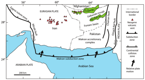
The Makran Trench is the physiographic expression of a subduction zone along the northeastern margin of the Gulf of Oman adjacent to the southwestern coast of Balochistan of Pakistan and the southeastern coast of Iran. In this region the oceanic crust of the Arabian plate is being subducted beneath the continental crust of the Eurasian plate. Tectonics In the Makran region, the Arabian plate subducts beneath the Eurasian plate at ~2-4cm/yr. This subduction is associated with an accretionary wedge of sediments which has developed since the Cenozoic. To the west, the Makran Trench is connected by the Minab Fault system to the Zagros fold and thrust belt. To the east, the Makran Trench is bounded by the transpressional strike-slip Ornach-Nal and Chaman Faults, which connect to the Himalayan orogeny. The Makran Subduction Zone is often split into two segments: the east and west. The Sonne fault divides the two. Though largely much quieter than many other subduction zo ... [...More Info...] [...Related Items...] OR: [Wikipedia] [Google] [Baidu] |
Nicobar Fan
Nicobar can refer to: * Nicobar Islands, a group of islands within the Indian union territory of Andaman and Nicobar Islands **Car Nicobar **Great Nicobar Island **Little Nicobar * Nicobar district, a district of the Indian union territory * '' Nicobar,'' a ship of the Danish Asiatic Company Animals * Nicobar shrew * Nicobar treeshrew *Nicobar long-tailed macaque * Nicobar flying fox * Nicobar pigeon * Nicobar megapode *Nicobar sparrowhawk *Nicobar parakeet *Nicobar bulbul *Central Nicobar serpent eagle *South Nicobar serpent eagle The Great Nicobar serpent eagle (''Spilornis klossi''), also known as the South Nicobar serpent eagle, is a species of bird of prey in the family Accipitridae. It is probably the smallest known eagle, with a weight of about , a wingspan of and a ... * Nicobar scops-owl * Nicobar crow See also * Nicobarese (other) * Car Nicobar (other) {{disambig, geo ... [...More Info...] [...Related Items...] OR: [Wikipedia] [Google] [Baidu] |
Enggano Island
Enggano Island (''Pulau Enggano'') is about southwest of Sumatra, Indonesia. It is one of the 92 officially listed outlying islands of Indonesia, though it can also be considered a barrier island of Sumatra. Geography Enggano (from Portuguese '' engano'' "mistake") is about long from east to west and about wide from north to south. Its area is including four small offshore islands around its coast - ''Pulau Merbau'', ''Pulau Dua'' and tiny ''Pulau Banggai'' off Enggano's east coast, and ''Pulau Satu'' off its south coast. The average elevation is about , and the highest point is . Villages There are six villages on Enggano Island, which are all located on the island's only main road, which traverses the island's north-east coast (Yoder 2011:6). * Kayaapu * Kaana * Malakoni * Apoho * Meok * Banjarsari Malakoni, Apoho, and Meok have more Enggano natives, and the other villages have larger immigrant populations. There are ferries to Bengkulu from Kahayapu and Malakoni (Yod ... [...More Info...] [...Related Items...] OR: [Wikipedia] [Google] [Baidu] |
Bengal Fan
The Bengal Fan, also known as the Ganges Fan, is the largest submarine fan on Earth. Geography It is located in the Bay of Bengal, being about long, wide with a maximum thickness of . The fan resulted from the uplift and erosion of the Himalayas and the Tibetan Plateau produced by the collision between the Indian Plate and the Eurasian Plate. Most of the sediment is supplied by the Ganges and Brahmaputra rivers which supply the Lower Meghna delta in Bangladesh and the Hooghly delta in West Bengal (India). Several other large rivers in Bangladesh and India provide smaller contributions. Turbidity currents have transported the sediment through a series of submarine canyons, some of which are more than 1,500 miles (2,414 km) in length, to be deposited in the Bay of Bengal up to 30 degrees latitude from where it began. To date, the oldest sediments recovered from the Bengal fan are from Early Miocene age. Their mineralogical and geochemical characteristics confirm thei ... [...More Info...] [...Related Items...] OR: [Wikipedia] [Google] [Baidu] |
Simeulue Island
Simeulue is an island of Indonesia, off the west coast of Sumatra. It covers an area of 1,754 square kilometre (677 square miles), including minor offshore islands. It had a population of 80,674 at the 2010 census and 92,865 at the 2020 census. The official estimate as at mid 2021 was 93,762. Simeulue was once a part of West Aceh Regency but was split off in 1999 and became a separate Simeulue Regency. Its capital is Sinabang. Demographics From the ethnic point of view the inhabitants of Simeulue are similar to the people of neighboring Nias Island. Two languages and a number of dialects are spoken on the island: Simeulue and Sigulai, which are different from the languages spoken in the north of Sumatra. The majority of the island's population is Muslim. History In the 17th century Tengku Di brought Islam to the island and the first mosque was built in Salur villiage. Simeulue was historically known to European mariners as "Hog Island"JH Moor '' Notices of the India ... [...More Info...] [...Related Items...] OR: [Wikipedia] [Google] [Baidu] |
Structure Of Accretionary Prism And Land Or Seaward Thrust Folds
A structure is an arrangement and organization of interrelated elements in a material object or system, or the object or system so organized. Material structures include man-made objects such as buildings and machines and natural objects such as biological organisms, minerals and chemicals. Abstract structures include data structures in computer science and musical form. Types of structure include a hierarchy (a cascade of one-to-many relationships), a network featuring many-to-many links, or a lattice featuring connections between components that are neighbors in space. Load-bearing Buildings, aircraft, skeletons, anthills, beaver dams, bridges and salt domes are all examples of load-bearing structures. The results of construction are divided into buildings and non-building structures, and make up the infrastructure of a human society. Built structures are broadly divided by their varying design approaches and standards, into categories including building structures, arch ... [...More Info...] [...Related Items...] OR: [Wikipedia] [Google] [Baidu] |
Myanmar
Myanmar, officially the Republic of the Union of Myanmar; and also referred to as Burma (the official English name until 1989), is a country in northwest Southeast Asia. It is the largest country by area in Mainland Southeast Asia and has a population of about 55 million. It is bordered by India and Bangladesh to its northwest, China to its northeast, Laos and Thailand to its east and southeast, and the Andaman Sea and the Bay of Bengal to its south and southwest. The country's capital city is Naypyidaw, and its largest city is Yangon (formerly Rangoon). Early civilisations in the area included the Tibeto-Burman-speaking Pyu city-states in Upper Myanmar and the Mon kingdoms in Lower Myanmar. In the 9th century, the Bamar people entered the upper Irrawaddy River, Irrawaddy valley, and following the establishment of the Pagan Kingdom in the 1050s, the Burmese language and Culture of Myanmar, culture and Buddhism in Myanmar, Theravada Buddhism slowly became dominant in the co ... [...More Info...] [...Related Items...] OR: [Wikipedia] [Google] [Baidu] |
Indo-Australian
Indian Australians or Indo-Australians are Australians of Indian ancestry. This includes both those who are Australian by birth, and those born in India or elsewhere in the Indian diaspora. Indian Australians are one of the largest groups within the Indian diaspora, with 783,958 persons declaring Indian ancestry at the 2021 census, representing 3.1% of the Australian population. In 2019, the Australian Bureau of Statistics estimated that 721,050 Australian residents were born in India. Indians are the youngest average age (34 years) and the fastest growing community both in terms of absolute numbers and percentages in Australia. In 2017–18 India was the largest source of new permanent annual migrants to Australia since 2016, and overall third largest source nation of cumulative total migrant population behind England and China, 20.5% or 33,310 out of 162,417 Australian permanent resident visas went to the Indians who also additionally had 70,000 students were studying in Au ... [...More Info...] [...Related Items...] OR: [Wikipedia] [Google] [Baidu] |


