|
Sudden Stratospheric Warmings
Sudden stratospheric warming (SSW) is an atmospheric phenomenon that occurs when polar stratospheric temperatures suddenly rise by several degrees (sometimes as much as 50 °C (90 °F)) over the course of a few days. SSW's occur high in the stratosphere, are often associated with Rossby waves and Polar Vortex breakdown and come in varying magnitudes. SSW events are significantly more common in the northern hemisphere than the southern hemisphere. History SSW's were discovered by Richard Scherhag, a German Meteorologist who worked at the Free University of Berlin. Starting in 1951, Scherhag launched radiosondes from Berlin's Tempelhof Airport to research temperature behavior in the upper stratosphere. However, on January 26th, 1952, Scherhag noticed that the upper stratosphere was beginning to warm at an abnormal rate. The warming continued for four days, by which time the upper stratosphere had warmed 33 °C. Scherhag reported this phenomenon in a journal later that ... [...More Info...] [...Related Items...] OR: [Wikipedia] [Google] [Baidu] |
Stratosphere
The stratosphere () is the second-lowest layer of the atmosphere of Earth, located above the troposphere and below the mesosphere. The stratosphere is composed of stratified temperature zones, with the warmer layers of air located higher (closer to outer space) and the cooler layers lower (closer to the planetary surface of the Earth). The increase of temperature with altitude is a result of the absorption of the Sun's ultraviolet (UV) radiation by the ozone layer, where ozone is exothermically photolyzed into oxygen in a cyclical fashion. This temperature inversion is in contrast to the troposphere, where temperature decreases with altitude, and between the troposphere and stratosphere is the tropopause border that demarcates the beginning of the temperature inversion. Near the equator, the lower edge of the stratosphere is as high as , at mid-latitudes around , and at the poles about . Temperatures range from an average of near the tropopause to an average of ne ... [...More Info...] [...Related Items...] OR: [Wikipedia] [Google] [Baidu] |
Polar Vortex
A polar vortex, more formally a circumpolar vortex, is a large region of cold, rotating air; polar vortices encircle both of Earth's polar regions. Polar vortices also exist on other rotating, low-obliquity planetary bodies. The term polar vortex can be used to describe two distinct phenomena; the stratospheric polar vortex, and the tropospheric polar vortex. The stratospheric and tropospheric polar vortices both rotate in the direction of the Earth's spin, but they are distinct phenomena that have different sizes, structures, seasonal cycles, and impacts on weather. The stratospheric polar vortex is an area of high-speed, cyclonically rotating winds around 15 km to 50 km high, poleward of 50°, and is strongest in winter. It forms during autumn when Arctic or Antarctic temperatures cool rapidly as the polar night begins. The increased temperature difference between the pole and the tropics causes strong winds, and the Coriolis effect causes the vortex to spin up. T ... [...More Info...] [...Related Items...] OR: [Wikipedia] [Google] [Baidu] |
Polar Amplification
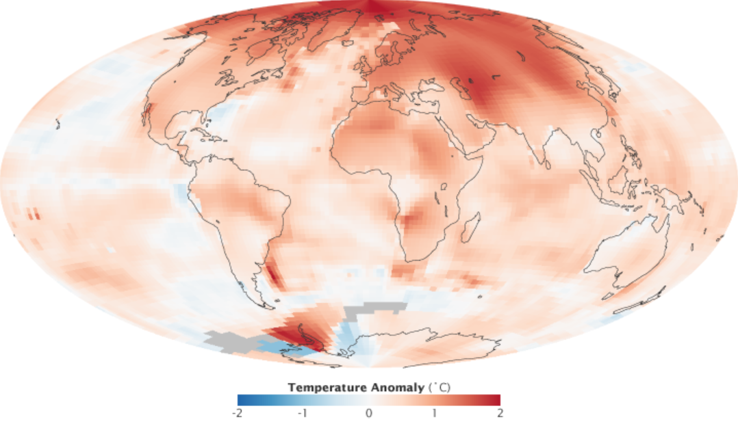
Polar amplification is the phenomenon that any change in the net radiation balance (for example greenhouse intensification) tends to produce a larger change in temperature near the poles than in the planetary average. This is commonly referred to as the ratio of polar warming to tropical warming. On a planet with an atmosphere that can restrict emission of longwave radiation to space (a greenhouse effect), surface temperatures will be warmer than a simple planetary equilibrium temperature calculation would predict. Where the atmosphere or an extensive ocean is able to transport heat polewards, the poles will be warmer and equatorial regions cooler than their local net radiation balances would predict. The poles will experience the most cooling when the global-mean temperature is lower relative to a reference climate; alternatively, the poles will experience the greatest warming when the global-mean temperature is higher. In the extreme, the planet Venus is thought to have experienc ... [...More Info...] [...Related Items...] OR: [Wikipedia] [Google] [Baidu] |
Straight-line Wind
In meteorology, a downburst is a strong downward and outward gushing wind system that emanates from a point source above and blows radially, that is, in straight lines in all directions from the area of impact at surface level. It originates under deep, moist convective conditions like cumulus congestus or cumulonimbus. Capable of producing damaging winds, it may sometimes be confused with a tornado, where high-velocity winds circle a central area, and air moves inward and upward. These usually last for seconds to minutes. Downbursts are particularly strong downdrafts within thunderstorms (or deep, moist convection as sometimes downbursts emanate from cumulonimbus or even cumulus congestus clouds that are not producing lightning). Downbursts are most often created by an area of significantly precipitation-cooled air that, after reaching the surface ( subsiding), spreads out in all directions producing strong winds. Dry downbursts are associated with thunderstorms that exhi ... [...More Info...] [...Related Items...] OR: [Wikipedia] [Google] [Baidu] |
Atmospheric Waveguide
An atmospheric waveguide is an atmospheric flow feature that improves the propagation of certain atmospheric waves. The effect arises because wave parameters such as group velocity or vertical wavenumber depend on mean flow direction and strength. Thus, for instance, westerlies might be a good waveguide for eastward-traveling waves, but might strongly dissipate westward-traveling waves, by increasing or decreasing their vertical wavenumber, respectively. Modification of the waves' group velocity will change their meridional propagation speed, directing them more polewards or more equator The equator is the circle of latitude that divides Earth into the Northern Hemisphere, Northern and Southern Hemisphere, Southern Hemispheres of Earth, hemispheres. It is an imaginary line located at 0 degrees latitude, about in circumferen ...wards. References {{planetary-science-stub Atmosphere ... [...More Info...] [...Related Items...] OR: [Wikipedia] [Google] [Baidu] |
Quasi-biennial Oscillation
The quasi-biennial oscillation (QBO) is a quasiperiodic oscillation of the equatorial zonal wind between easterlies and westerlies in the tropical stratosphere with a mean period of 28 to 29 months. The alternating wind regimes develop at the top of the lower stratosphere and propagate downwards at about per month until they are dissipated at the tropopause. Downward motion of the easterlies is usually more irregular than that of the westerlies. The amplitude of the easterly phase is about twice as strong as that of the westerly phase. At the top of the vertical QBO domain, easterlies dominate, while at the bottom, westerlies are more likely to be found. At the level, with regards to monthly mean zonal winds, the strongest recorded easterly was 29.55 m/s in November 2005, while the strongest recorded westerly was only 15.62 m/s in June 1995. Theory In 1883, the eruption of Krakatoa led to visual tracking of subsequent volcanic ash in the stratosphere. This visua ... [...More Info...] [...Related Items...] OR: [Wikipedia] [Google] [Baidu] |
Block (meteorology)
Blocks in meteorology are large-scale patterns in the atmospheric pressure field that are nearly stationary, effectively "blocking" or redirecting migratory cyclones. They are also known as blocking highs or blocking anticyclones.Glossary of Meteorology, Second Edition; American Meteorological Society, 2000; . These blocks can remain in place for several days or even weeks, causing the areas affected by them to have the same kind of weather for an extended period of time (e.g. precipitation for some areas, clear skies for others). In the Northern Hemisphere, extended blocking occurs most frequently in the spring over the eastern Pacific and Atlantic Oceans. While these events are linked to the occurrence of extreme weather events such as heat waves, particularly the onset and decay of these events is still not well captured in numerical weather forecasts and remains an open area of research. Impact of the polar vortex Polar cyclones are climatological features which hover near ... [...More Info...] [...Related Items...] OR: [Wikipedia] [Google] [Baidu] |
Low-pressure Area
In meteorology, a low-pressure area (LPA), low area or low is a region where the atmospheric pressure is lower than that of surrounding locations. It is the opposite of a high-pressure area. Low-pressure areas are commonly associated with inclement weather (such as cloudy, windy, with possible rain or storms), while high-pressure areas are associated with lighter winds and clear skies. Winds circle anti-clockwise around lows in the northern hemisphere, and clockwise in the southern hemisphere, due to opposing Coriolis forces. Low-pressure systems form under areas of wind divergence that occur in the upper levels of the atmosphere (aloft). The formation process of a low-pressure area is known as cyclogenesis. In meteorology, atmospheric divergence aloft occurs in two kinds of places: * The first is in the area on the east side of upper troughs, which form half of a Rossby wave within the Westerlies (a trough with large wavelength that extends through the troposphere). * A ... [...More Info...] [...Related Items...] OR: [Wikipedia] [Google] [Baidu] |
Troposphere
The troposphere is the lowest layer of the atmosphere of Earth. It contains 80% of the total mass of the Atmosphere, planetary atmosphere and 99% of the total mass of water vapor and aerosols, and is where most weather phenomena occur. From the planetary surface of the Earth, the average height of the troposphere is in the tropics; in the middle latitudes; and in the high latitudes of the polar regions in winter; thus the average height of the troposphere is . The term ''troposphere'' derives from the Greek words ''tropos'' (rotating) and ''sphere, sphaira'' (sphere) indicating that rotational turbulence mixes the layers of air and so determines the structure and the phenomena of the troposphere. The rotational friction of the troposphere against the planetary surface affects the flow of the air, and so forms the planetary boundary layer (PBL) that varies in height from hundreds of meters up to . The measures of the PBL vary according to the latitude, the landform, and the t ... [...More Info...] [...Related Items...] OR: [Wikipedia] [Google] [Baidu] |
Rossby Waves
Rossby waves, also known as planetary waves, are a type of inertial wave naturally occurring in rotating fluids. They were first identified by Sweden-born American meteorologist Carl-Gustaf Arvid Rossby in the Earth's atmosphere in 1939. They are observed in the atmospheres and oceans of Earth and other planets, owing to the rotation of Earth or of the planet involved. Atmospheric Rossby waves on Earth are giant meanders in high-altitude winds that have a major influence on weather. These waves are associated with pressure systems and the jet stream (especially around the Polar vortex, polar vortices). Oceanic Rossby waves move along the thermocline: the boundary between the warm upper layer and the cold deeper part of the ocean. Rossby wave types Atmospheric waves Atmospheric Rossby waves result from the conservation of potential vorticity and are influenced by the Coriolis force and pressure gradient. The image on the left sketches fundamental principles of the wave, e.g., its ... [...More Info...] [...Related Items...] OR: [Wikipedia] [Google] [Baidu] |
Weather Satellite
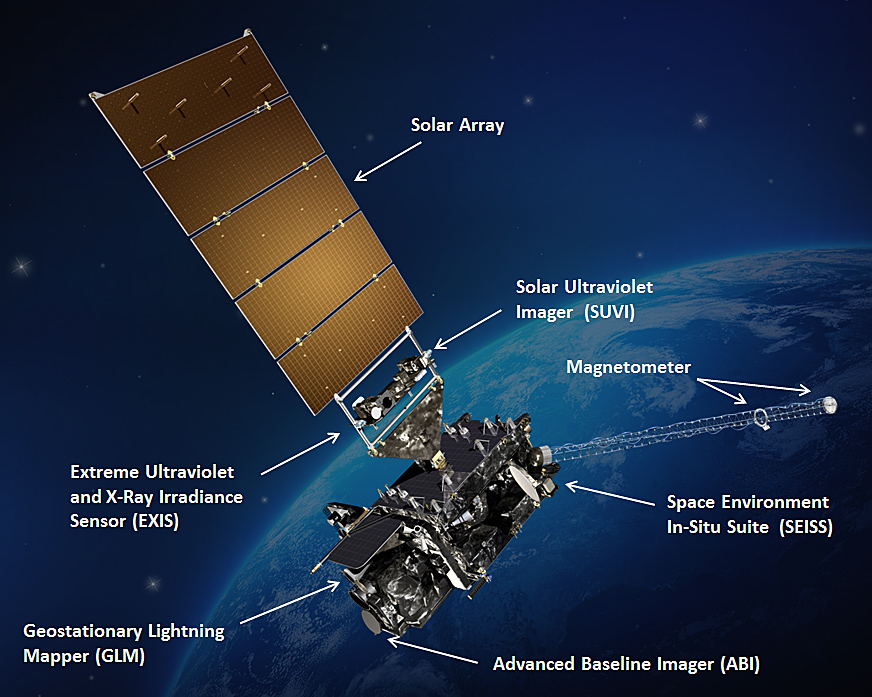
A weather satellite or meteorological satellite is a type of Earth observation satellite that is primarily used to monitor the weather and climate of the Earth. Satellites are mainly of two types: polar orbiting (covering the entire Earth asynchronously) or geostationary (hovering over the same spot on the equator). While primarily used to detect the development and movement of storm systems and other cloud patterns, meteorological satellites can also detect other phenomena such as city lights, fires, effects of pollution, auroras, sand and dust storms, snow cover, ice mapping, boundaries of ocean currents, and energy flows. Other types of environmental information are collected using weather satellites. Weather satellite images helped in monitoring the volcanic ash cloud from Mount St. Helens and activity from other volcanoes such as Mount Etna. Smoke from fires in the western United States such as Colorado and Utah have also been monitored. El Niño and its effects on wea ... [...More Info...] [...Related Items...] OR: [Wikipedia] [Google] [Baidu] |


