|
Submarine Canyons
A submarine canyon is a steep-sided valley cut into the seabed of the continental slope, sometimes extending well onto the continental shelf, having nearly vertical walls, and occasionally having canyon wall heights of up to , from canyon floor to canyon rim, as with the Great Bahama Canyon. Just as above-sea-level canyons serve as channels for the flow of water across land, submarine canyons serve as channels for the flow of turbidity currents across the seafloor. Turbidity currents are flows of dense, sediment laden waters that are supplied by rivers, or generated on the seabed by storms, submarine landslides, earthquakes, and other soil disturbances. Turbidity currents travel down slope at great speed (as much as ), eroding the continental slope and finally depositing sediment onto the abyssal plain, where the particles settle out.Continental Margin Sedimentation: From Sediment Transport to Sequence Stratigraphy (Special Publication 37 of the IAS) March 2009, by Charles ... [...More Info...] [...Related Items...] OR: [Wikipedia] [Google] [Baidu] |
Sea Level
Mean sea level (MSL, often shortened to sea level) is an mean, average surface level of one or more among Earth's coastal Body of water, bodies of water from which heights such as elevation may be measured. The global MSL is a type of vertical datuma standardised geodetic datumthat is used, for example, as a chart datum in cartography and Navigation, marine navigation, or, in aviation, as the standard sea level at which atmospheric pressure is measured to Calibration, calibrate altitude and, consequently, aircraft flight levels. A common and relatively straightforward mean sea-level standard is instead a long-term average of tide gauge readings at a particular reference location. The term ''above sea level'' generally refers to the height above mean sea level (AMSL). The term APSL means above present sea level, comparing sea levels in the past with the level today. Earth's radius at sea level is 6,378.137 km (3,963.191 mi) at the equator. It is 6,356.752 km (3,94 ... [...More Info...] [...Related Items...] OR: [Wikipedia] [Google] [Baidu] |
Slump (geology)
A slump is a form of mass wasting that occurs when a coherent mass of loosely consolidated materials or a rock layer moves a short distance down a Grade (slope), slope. Movement is characterized by sliding along a concave-upward or planar surface. Causes of slumping include earthquake shocks, thorough wetting, freezing and thawing, undercutting, and loading of a slope. Translational slumps occur when a detached landmass moves along a planar surface. Common planar surfaces of failure include joints or bedding planes, especially where a permeable layer overrides an impermeable surface. Block slumps are a type of translational slump in which one or more related block units move downslope as a relatively coherent mass. A rotational slump occurs when a slump block, composed of sediment or rock, slides along a concave-upward slip surface with rotation about an axis parallel to the slope. Rotational movement causes the original surface of the block to become less steep, and the top of ... [...More Info...] [...Related Items...] OR: [Wikipedia] [Google] [Baidu] |
Bioerosion
Bioerosion describes the breakdown of hard ocean substrates – and less often terrestrial substrates – by living organisms. Marine bioerosion can be caused by mollusks, polychaete worms, phoronids, sponges, crustaceans, echinoids, and fish; it can occur on coastlines, on coral reefs, and on ships; its mechanisms include biotic boring, drilling, rasping, and scraping. On dry land, bioerosion is typically performed by pioneer plants or plant-like organisms such as lichen, and mostly chemical (e.g. by acidic secretions on limestone) or mechanical (e.g. by roots growing into cracks) in nature. Bioerosion of coral reefs generates the fine and white coral sand characteristic of tropical islands. The coral is converted to sand by internal bioeroders such as algae, fungi, bacteria (microborers) and sponges (Clionaidae), bivalves (including '' Lithophaga''), sipunculans, polychaetes, acrothoracican barnacles and phoronids, generating extremely fine sediment with diame ... [...More Info...] [...Related Items...] OR: [Wikipedia] [Google] [Baidu] |
Rock (geology)
In geology, rock (or stone) is any naturally occurring solid mass or aggregate of minerals or mineraloid matter. It is categorized by the minerals included, its Chemical compound, chemical composition, and the way in which it is formed. Rocks form the Earth's outer solid layer, the Earth's crust, crust, and most of its interior, except for the liquid Earth's outer core, outer core and pockets of magma in the asthenosphere. The study of rocks involves multiple subdisciplines of geology, including petrology and mineralogy. It may be limited to rocks found on Earth, or it may include planetary geology that studies the rocks of other celestial objects. Rocks are usually grouped into three main groups: igneous rocks, sedimentary rocks and metamorphic rocks. Igneous rocks are formed when magma cools in the Earth's crust, or lava cools on the ground surface or the seabed. Sedimentary rocks are formed by diagenesis and lithification of sediments, which in turn are formed by the weathe ... [...More Info...] [...Related Items...] OR: [Wikipedia] [Google] [Baidu] |
Crystal
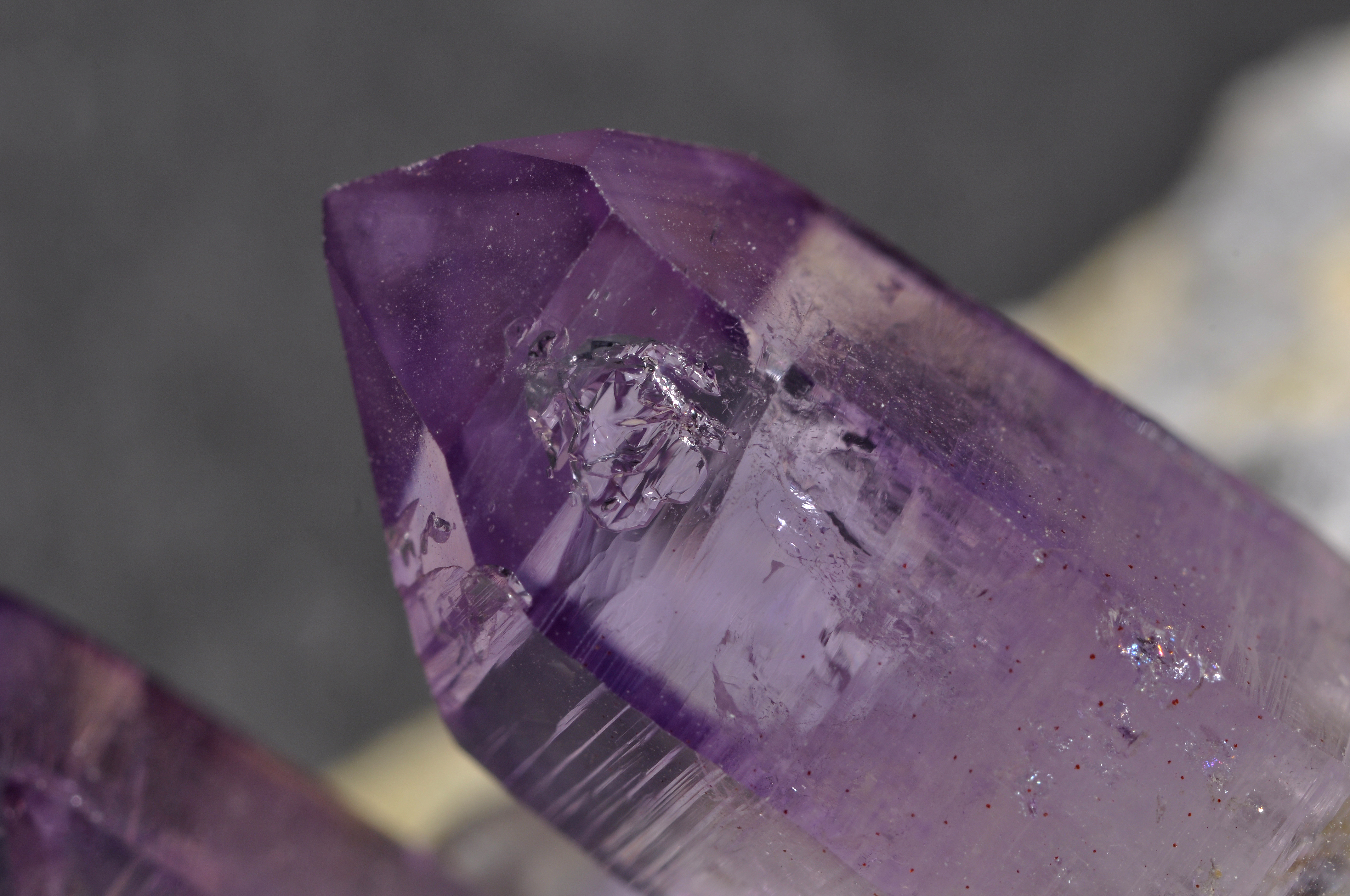
A crystal or crystalline solid is a solid material whose constituents (such as atoms, molecules, or ions) are arranged in a highly ordered microscopic structure, forming a crystal lattice that extends in all directions. In addition, macroscopic single crystals are usually identifiable by their geometrical shape, consisting of flat faces with specific, characteristic orientations. The scientific study of crystals and crystal formation is known as crystallography. The process of crystal formation via mechanisms of crystal growth is called crystallization or solidification. The word ''crystal'' derives from the Ancient Greek word (), meaning both "ice" and " rock crystal", from (), "icy cold, frost". Examples of large crystals include snowflakes, diamonds, and table salt. Most inorganic solids are not crystals but polycrystals, i.e. many microscopic crystals fused together into a single solid. Polycrystals include most metals, rocks, ceramics, and ice. A third cat ... [...More Info...] [...Related Items...] OR: [Wikipedia] [Google] [Baidu] |
Sediment
Sediment is a solid material that is transported to a new location where it is deposited. It occurs naturally and, through the processes of weathering and erosion, is broken down and subsequently sediment transport, transported by the action of wind, water, or ice or by the force of gravity acting on the particles. For example, sand and silt can be carried in suspension (chemistry), suspension in river water and on reaching the sea bed deposited by sedimentation; if buried, they may eventually become sandstone and siltstone (sedimentary rocks) through lithification. Sediments are most often transported by water (fluvial, fluvial processes), but also wind (aeolian processes) and glaciers. Beach sands and stream channel, river channel deposits are examples of fluvial transport and deposition (geology), deposition, though sediment also often settles out of slow-moving or standing water in lakes and oceans. Desert sand dunes and loess are examples of aeolian transport and deposition. ... [...More Info...] [...Related Items...] OR: [Wikipedia] [Google] [Baidu] |
Lithification
Lithification (from the Ancient Greek word ''lithos'' meaning 'rock' and the Latin-derived suffix ''-ific'') is the process in which sediments compact under pressure, expel connate fluids, and gradually become solid rock. Essentially, lithification is a process of porosity destruction through compaction and cementation. Lithification includes all the processes which convert unconsolidated sediments into sedimentary rocks. '' Petrifaction'', though often used as a synonym, is more specifically used to describe the replacement of organic material by silica in the formation of fossil A fossil (from Classical Latin , ) is any preserved remains, impression, or trace of any once-living thing from a past geological age. Examples include bones, shells, exoskeletons, stone imprints of animals or microbes, objects preserve ...s. See also * * * * * * References Geological processes Petrology Sedimentary rocks {{sedimentology-stub ... [...More Info...] [...Related Items...] OR: [Wikipedia] [Google] [Baidu] |
Erosion
Erosion is the action of surface processes (such as Surface runoff, water flow or wind) that removes soil, Rock (geology), rock, or dissolved material from one location on the Earth's crust#Crust, Earth's crust and then sediment transport, transports it to another location where it is deposit (geology), deposited. Erosion is distinct from weathering which involves no movement. Removal of rock or soil as clastic sediment is referred to as ''physical'' or ''mechanical'' erosion; this contrasts with ''chemical'' erosion, where soil or rock material is removed from an area by Solvation, dissolution. Eroded sediment or solutes may be transported just a few millimetres, or for thousands of kilometres. Agents of erosion include rainfall; bedrock wear in rivers; coastal erosion by the sea and Wind wave, waves; glacier, glacial Plucking (glaciation), plucking, Abrasion (geology), abrasion, and scour; areal flooding; Aeolian processes, wind abrasion; groundwater processes; and Mass wastin ... [...More Info...] [...Related Items...] OR: [Wikipedia] [Google] [Baidu] |
Passive Margin
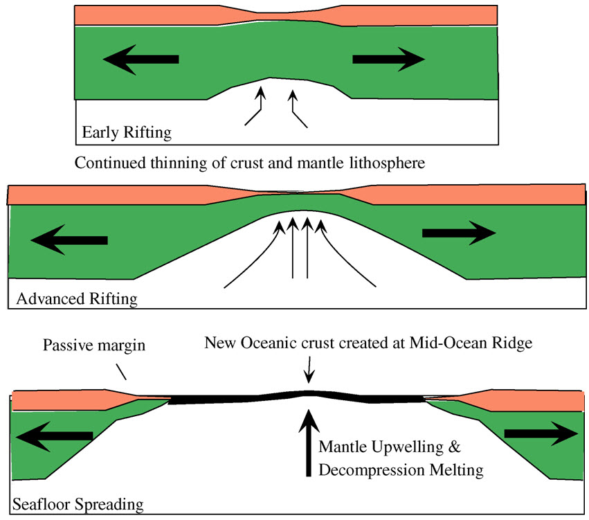
A passive margin is the transition between Lithosphere#Oceanic lithosphere, oceanic and Lithosphere#Continental lithosphere, continental lithosphere that is not an active plate continental margin, margin. A passive margin forms by sedimentation above an ancient rift, now marked by transitional lithosphere. Continental rifting forms new ocean basins. Eventually the continental rift forms a mid-ocean ridge and the locus of extensional tectonics, extension moves away from the continent-ocean boundary. The transition between the continental and oceanic lithosphere that was originally formed by rifting is known as a passive margin. Global distribution Passive margins are found at every ocean and continent boundary that is not marked by a Fault (geology)#Strike-slip faults, strike-slip fault or a subduction, subduction zone. Passive margins define the region around the Arctic Ocean, Atlantic Ocean, and western Indian Ocean, and define the entire coasts of Africa, Australia, Greenla ... [...More Info...] [...Related Items...] OR: [Wikipedia] [Google] [Baidu] |
Active Margin
A convergent boundary (also known as a destructive boundary) is an area on Earth where two or more lithospheric plates collide. One plate eventually slides beneath the other, a process known as subduction. The subduction zone can be defined by a plane where many earthquakes occur, called the Wadati–Benioff zone. These collisions happen on scales of millions to tens of millions of years and can lead to volcanism, earthquakes, orogenesis, destruction of lithosphere, and deformation. Convergent boundaries occur between oceanic-oceanic lithosphere, oceanic-continental lithosphere, and continental-continental lithosphere. The geologic features related to convergent boundaries vary depending on crust types. Plate tectonics is driven by convection cells in the mantle. Convection cells are the result of heat generated by the radioactive decay of elements in the mantle escaping to the surface and the return of cool materials from the surface to the mantle. These convection cells bri ... [...More Info...] [...Related Items...] OR: [Wikipedia] [Google] [Baidu] |
Abyssal Fan
Abyssal fans, also known as deep-sea fans, underwater deltas, and submarine fans, are underwater geological structures associated with large-scale sediment deposition and formed by turbidity currents. They can be thought of as an underwater version of alluvial fans and can vary dramatically in size, with widths from several kilometres to several thousands of kilometres. The largest is the Bengal Fan, followed by the Indus Fan, but major fans are also found at the outlet of the Amazon, Congo, Mississippi and elsewhere. Formation Abyssal (or submarine) fans are formed from turbidity currents. These currents begin when a geologic activity pushes sediments over the edge of a continental shelf and down the continental slope, creating an underwater landslide. A dense slurry of muds and sand Sand is a granular material composed of finely divided mineral particles. Sand has various compositions but is usually defined by its grain size. Sand grains are smaller than ... [...More Info...] [...Related Items...] OR: [Wikipedia] [Google] [Baidu] |


