|
Stolsvatnet
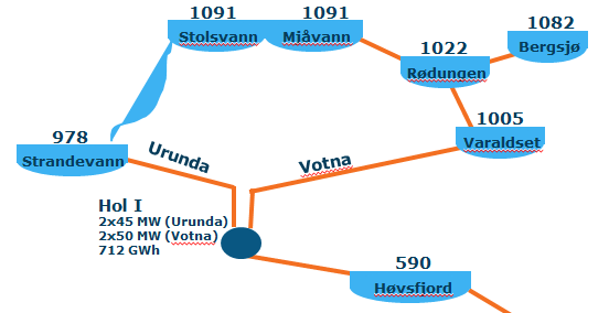
Stolsvatnet is a regulated lake in the municipalities of Ål and Hol in Buskerud, Norway. Stolsvatnet was formed in the late 1940s by the damming of the upper parts of three rivers, (Stolsvatn, Olsendvatn, Holselva) which created a continuous lake across the watersheds. The new lake covered a number of existing smaller lakes. It is a reservoir for Hol I kraftverk, a hydroelectric power plant located off FV 50 by Hovet in Hol. The power plant is owned and operated by E-Co Energi. See also *Strandavatnet Strandavatnet is a lake in Hol, Norway, Hol municipality, Norway. The lake covers an area of , and lies above sea level.' The lake is a reservoir for the Rud hydroelectric powerstation in Hovet, Buskerud. In 1952/1953 a dam was constructed which ... References External linksE-Co Energi Ål Hol, Norway Lakes of Buskerud {{Norway-lake-stub ... [...More Info...] [...Related Items...] OR: [Wikipedia] [Google] [Baidu] |
Strandavatnet
Strandavatnet is a lake in Hol, Norway, Hol municipality, Norway. The lake covers an area of , and lies above sea level.' The lake is a reservoir for the Rud hydroelectric powerstation in Hovet, Buskerud. In 1952/1953 a dam was constructed which lifted the lake level 28 meters, thus the lake varies between 950 and 978 m above sea level. First rock filling dam in Norway The dam in the Strandavatnet was the first rock filling (embankment) dam in Norway. You can see the dam on your left hand side from FV 50 at Myrland (the road to Raggsteindalen goes over the dam). The Hol 1 power station, in Hovet, Buskerud utilizes water from two watercourses, Urunda, where Strandavatnet, is the intake reservoir, and Votna where Varaldset is the intake reservoir. Stolsvatnet is the biggest and highest reservoir in the Votna watercourse. See figure below.E-CO energi Overview of two watercourses Photos A frozen Strandavatnet.jpg, A frozen Strandavatnet Surroundings of Strandavatnet.jpg, Surroun ... [...More Info...] [...Related Items...] OR: [Wikipedia] [Google] [Baidu] |
Hovet, Buskerud
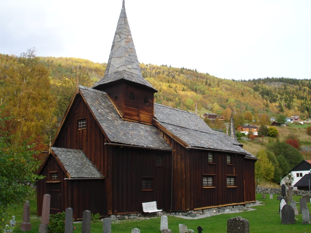
Hovet is a mountain village in Hol, Norway, Hol, Buskerud, Norway. Hovet is located between Strandavatnet and Hovsfjorden. Hovet is the site of Hovet Chapel (''Hovet kapell''). The church is located in the south-east slope of a hill that shoots out into the valley from the north. It was constructed from drawings prepared by architect Ole Stein and inaugurated in 1910. The walls are built of timber frame and rest on a grouted natural stone foundation. All roofs are covered with slate. Håkonsæt Fjellvilla is a mountain villa. It is situated in the centre of Hovet, near Hallingskarvet National Park, 15 minutes from Skisenter Hallingskarvet in Sudndalen, Hovet. and 20 min from the ski resorts of Geilo. Hallingdal Hovet belongs to the traditional district of Hallingdal, the Halling Valley, created by the Hallingdalselva or Hallingdal River. "Elva" is Norwegian for river. The Hallingdal River, also named "big river" or Storåni, originates from the Hardangervidda national park, s ... [...More Info...] [...Related Items...] OR: [Wikipedia] [Google] [Baidu] |
Hol, Norway
Hol is a Municipalities of Norway, municipality in Buskerud Counties of Norway, county, Norway. Administrative history The area of Hol was separated from the municipality Ål in 1877 to become a separate municipality. In 1937 a part of neighboring Uvdal with 220 inhabitants moved to Hol municipality. The area was transferred from Uvdal to Hol in 1944. Uvdal was reunited with Nore to form the new municipality of Nore og Uvdal. General information Name The municipality (originally the parish) is named after the old ''Hol'' farm (Old Norse: ), since the first church was built here. The name is identical with the word , which means 'round (and isolated) hill'. Villages and hamlets in Hol municipality * Dagali * Geilo * Hagafoss * Hol * Hovet, Buskerud, Hovet * Kvisla, Buskerud, Kvisla * Myrland * Strønde * Sudndalen * Vedalen Geography Hol is bordered to the north by Lærdal, to the north and east by Ål, to the south by Nore og Uvdal, and to the west by Eidfjord, Ulvik and A ... [...More Info...] [...Related Items...] OR: [Wikipedia] [Google] [Baidu] |
Buskerud
Buskerud () is a Counties of Norway, county and a current electoral district in Norway, bordering Akershus, Oslo, Innlandet, Vestland, Telemark and Vestfold. The region extends from the Oslofjord and Drammensfjorden in the southeast to Hardangervidda mountain range in the northwest. The county administration was in modern times located in Drammen. Buskerud was merged with Akershus and Østfold into the newly created Viken (county), Viken County on 1 January 2020. On 23 February 2022, the Viken County Council voted in a 49 against 38 decision to submit an application to the Norwegian government for a county demerger. Due to this, Buskerud (except the area forming the defunct municipalities of Røyken and Hurum) was re-established in 2024. Etymology The county was named after the old manor Buskerud Manor, Buskerud () (Biskopsrøysa) located on the west side of the Drammenselva, Drammen River in Åmot, Buskerud, Åmot, Modum municipality. The first element is the genitive case of ', ... [...More Info...] [...Related Items...] OR: [Wikipedia] [Google] [Baidu] |
Norwegian Water Resources And Energy Directorate
The Norwegian Water Resources and Energy Directorate ( or NVE) is a Norwegian government agency established in 1921. It is under the Ministry of Petroleum and Energy and regulates the country's water resources and energy supply. Its mandate includes contingency planning for floods, serving as a centre of expertise for hydrology, research and development, and increasing energy efficiency. It is a member of the Council of European Energy Regulators. The directorate is based in Oslo and has regional offices in Hamar, Førde, Tønsberg, Trondheim, and Narvik. It also establishes international contacts and undertakes work abroad in developing countries for the Norwegian Agency for Development Cooperation. , it had over 400 employees. Its website includes statistics on Norwegian energy consumption, production, and prices and a database of Norwegian lakes and water catchment areas. The directorate is administratively responsible for the Watercourse Regulation Act (1917), Indu ... [...More Info...] [...Related Items...] OR: [Wikipedia] [Google] [Baidu] |
Norway
Norway, officially the Kingdom of Norway, is a Nordic countries, Nordic country located on the Scandinavian Peninsula in Northern Europe. The remote Arctic island of Jan Mayen and the archipelago of Svalbard also form part of the Kingdom of Norway. Bouvet Island, located in the Subantarctic, is a Dependencies of Norway, dependency, and not a part of the Kingdom; Norway also Territorial claims in Antarctica, claims the Antarctic territories of Peter I Island and Queen Maud Land. Norway has a population of 5.6 million. Its capital and largest city is Oslo. The country has a total area of . The country shares a long eastern border with Sweden, and is bordered by Finland and Russia to the northeast. Norway has an extensive coastline facing the Skagerrak strait, the North Atlantic Ocean, and the Barents Sea. The unified kingdom of Norway was established in 872 as a merger of Petty kingdoms of Norway, petty kingdoms and has existed continuously for years. From 1537 to 1814, Norway ... [...More Info...] [...Related Items...] OR: [Wikipedia] [Google] [Baidu] |
Reservoir
A reservoir (; ) is an enlarged lake behind a dam, usually built to water storage, store fresh water, often doubling for hydroelectric power generation. Reservoirs are created by controlling a watercourse that drains an existing body of water, interrupting a watercourse to form an Bay, embayment within it, excavating, or building any number of retaining walls or levees to enclose any area to store water. Types Dammed valleys Dammed reservoirs are artificial lakes created and controlled by a dam constructed across a valley and rely on the natural topography to provide most of the basin of the reservoir. These reservoirs can either be ''on-stream reservoirs'', which are located on the original streambed of the downstream river and are filled by stream, creeks, rivers or rainwater that surface runoff, runs off the surrounding forested catchments, or ''off-stream reservoirs'', which receive water diversion, diverted water from a nearby stream or aqueduct (water supply), aq ... [...More Info...] [...Related Items...] OR: [Wikipedia] [Google] [Baidu] |


