|
Stadtallendorf
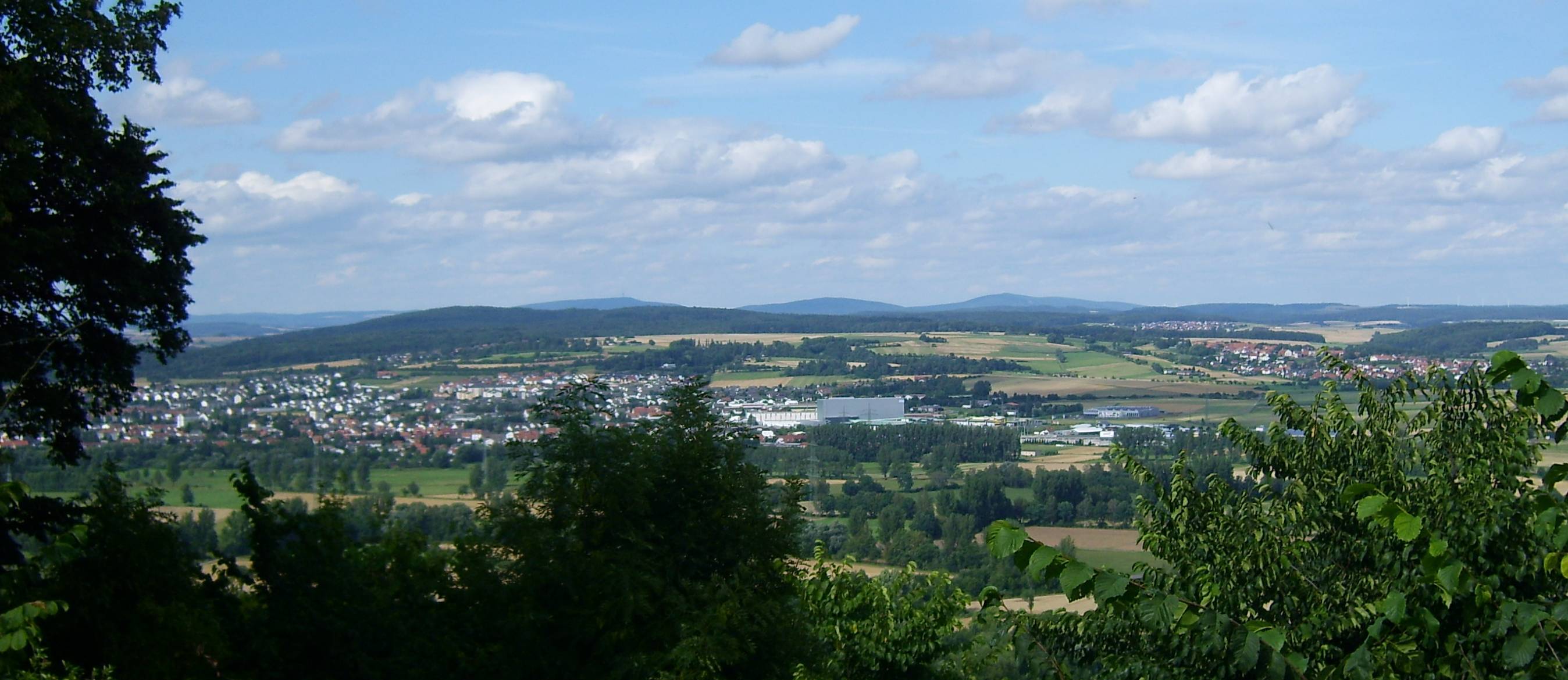
Stadtallendorf is a town in the district of Marburg-Biedenkopf, Hesse, Germany. It lies about east of Marburg. In 2010, the town hosted the 50th Hessentag state festival. Geography Location Under the German system of ''Naturräume'', Stadtallendorf lies in the West Hesse Depression zone (''westhessische Senkenzone'') which is divided into basins and ridges. With respect to these, the town lies on the Upper Hesse Ridge which separates the Amöneburg Basin in the west from the ''Schwalmbecken'' (another basin) in the east. On this ridge may also be found the Neustadt Saddle, abutted by the town's northeast edge. This upland is part of the Water divide, divide between the Rhine and Weser Drainage basin, watersheds. Neighbouring communities Stadtallendorf borders in the north on the town of Rauschenberg, Hesse, Rauschenberg (Marburg-Biedenkopf) and the community of Gilserberg (Schwalm-Eder-Kreis), in the east on the town of Neustadt, Hesse, Neustadt, in the southeast on the to ... [...More Info...] [...Related Items...] OR: [Wikipedia] [Google] [Baidu] |
Upper Hesse Ridge
The Upper Hessian Ridge (german: Oberhessische Schwelle) or Upper Hesse Ridge is a hill chain in the West Hesse Highlands in North and Middle Hesse, which lies on the Rhine-Weser watershed and links the montane Central Upland ranges of the Kellerwald and the Vogelsberg in a north-south direction. The swell is divided into the Gilserberg Heights (''Gilserberger Höhen'') in the north, the central Neustadt Saddle (''Neustädter Sattel'') and the Northern Vogelsberg Foreland (''Nördliche Vogelsberg-Vorland'') in the south. Location In the north the Gilserberg Heights transition directly into the clearly much higher Kellerwald with its prominent hills, the Jeust and the Wüstegarten; to the northeast into the Löwenstein Bottom, which is part of the ''Ostwaldecker Randsenken''. Separated by the Wohra the ridge is adjoined in the northwest by the Burgwald at the Gilserberg Heights. In the southwest the Ohm and the flat Amöneburg Basin follows by the Neustadt Saddle and the North ... [...More Info...] [...Related Items...] OR: [Wikipedia] [Google] [Baidu] |
Hessentag
The Hessentag (; en, Hesse Day) is an annual event, both fair and festival, organized by the German state of Hesse to represent the different regions of Hesse. The events are shown for a week to the visitors, with an emphasis on cultural displays and exhibitions. It is the oldest and largest state festival ( Landesfest) in Germany. History The Hessentag was launched in 1961 by the prime minister of Hesse, Georg August Zinn. The event was intended to bring together long-time residents and migrants and to provide a sense of their new home to the many refugees and displaced persons. Hesse itself had to catch up in terms of togetherness; the state was only created in 1945 by a decision of the victorious powers of World War II, from areas with different history and development. Georg August Zinn knew how to integrate the various new "Hessians", following his motto: "Hesse ist, wer Hesse sein will" (A Hessian is anybody who wants to be a Hessian"). The first Hessentag in Alsfeld in ... [...More Info...] [...Related Items...] OR: [Wikipedia] [Google] [Baidu] |
Rauschenberg, Hesse
Rauschenberg is a town in the north of Marburg-Biedenkopf district in Hesse, Germany. Geography Location Rauschenberg lies at the southern edge of the ''Burgwald'', a low mountain range, near Marburg and Kirchhain. Neighbouring communities Rauschenberg borders in the north on the town of Rosenthal (Waldeck-Frankenberg) as well as on the communities of Wohratal (Marburg-Biedenkopf) and Gilserberg (Schwalm-Eder-Kreis), in the east on the town of Stadtallendorf, in the south on the town of Kirchhain, in the southwest on the community of Cölbe, and in the west on the town of Wetter (all in Marburg-Biedenkopf). Municipality divisions Rauschenberg consists out of following villages: * Albshausen * Bracht * Ernsthausen * Josbach * Rauschenberg (town) * Schwabendorf * Wolfskaute History Even as far back as 1000, a castle was built in what is now Rauschenberg. After a fire about 1250, almost the whole settlement was destroyed. Shortly after Rauschenberg was founded by the Counts of ... [...More Info...] [...Related Items...] OR: [Wikipedia] [Google] [Baidu] |
Hesse
Hesse (, , ) or Hessia (, ; german: Hessen ), officially the State of Hessen (german: links=no, Land Hessen), is a state in Germany. Its capital city is Wiesbaden, and the largest urban area is Frankfurt. Two other major historic cities are Darmstadt and Kassel. With an area of 21,114.73 square kilometers and a population of just over six million, it ranks seventh and fifth, respectively, among the sixteen German states. Frankfurt Rhine-Main, Germany's second-largest metropolitan area (after Rhine-Ruhr), is mainly located in Hesse. As a cultural region, Hesse also includes the area known as Rhenish Hesse (Rheinhessen) in the neighbouring state of Rhineland-Palatinate. Name The German name '' Hessen'', like the names of other German regions (''Schwaben'' "Swabia", ''Franken'' "Franconia", ''Bayern'' "Bavaria", ''Sachsen'' "Saxony"), derives from the dative plural form of the name of the inhabitants or eponymous tribe, the Hessians (''Hessen'', singular ''Hesse''). The g ... [...More Info...] [...Related Items...] OR: [Wikipedia] [Google] [Baidu] |
Homberg (Ohm)
Homberg (Ohm) () is a town in the Vogelsbergkreis in Hesse, Germany. Geography Location The officially recognized climatic spa of Homberg lies from 203 to 350 m above sea level in the valley of the Ohm, a tributary to the Lahn, some 19 km southeast of Marburg. Neighbouring communities Homberg borders in the north on the town of Stadtallendorf (Marburg-Biedenkopf), in the northeast on the town of Kirtorf, in the southeast on the community of Gemünden, in the south on the community of Mücke, in the southwest on the town of Grünberg and the community of Rabenau (both in Gießen district), in the west on the community of Ebsdorfergrund, and in the northwest on the town of Amöneburg (both in Marburg-Biedenkopf). Constituent communities The town of Homberg consists of not only the namesake main town, but also of the outlying centres of Appenrod, Bleidenrod, Büßfeld, Dannenrod, Deckenbach, Erbenhausen, Gontershausen, Haarhausen, Höingen, Maulbach, Nieder-Ofleiden, Ober-Of ... [...More Info...] [...Related Items...] OR: [Wikipedia] [Google] [Baidu] |
Kirtorf
Kirtorf () is a town in the northern Vogelsbergkreis in Hesse, Germany. Through the town runs the ''Deutsche Märchenstraße'', or German Fairytale Road, a touristic route joining many of the places commonly associated with the Brothers Grimm's tales. Geography The town lies at the top of the Rhine-Weser watershed between the east-flowing Antrift and the west-flowing Gleen. Neighbouring communities Kirtorf borders in the north on the town of Neustadt (Marburg-Biedenkopf), in the east on the community of Antrifttal, the town of Alsfeld and the community of Romrod, in the south on the community of Gemünden, and in the west on the town of Homberg (Ohm), and the town of Stadtallendorf (Marburg-Biedenkopf). Constituent communities Besides the town's main centre, which bears the same name as the whole municipality, there are outlying centres named Arnshain, Gleimenhain, Heimertshausen, Lehrbach, Ober-Gleen and Wahlen. History Kirtorf was mentioned in a document as ''Gleene'' in 917 ... [...More Info...] [...Related Items...] OR: [Wikipedia] [Google] [Baidu] |
Neustadt, Hesse
Neustadt is a town in the Marburg-Biedenkopf district in Hesse, Germany. Geography Location Neustadt lies in the Middle Hessian ''Bergland'' ("Highland") at the eastern end of Marburg-Biedenkopf district. Neighbouring communities Neustadt borders in the north on the community of Gilserberg, in the east on the town of Schwalmstadt and the community of Willingshausen (all three in the Schwalm-Eder-Kreis), in the southeast on the community of Antrifttal, in the south on the town of Kirtorf (both in the Vogelsbergkreis), and in the west on the town of Stadtallendorf (Marburg-Biedenkopf). Town divisions Neustadt has, as well as the core community known as Neustadt, centres known as Mengsberg, Momberg and Speckswinkel. Politics Town council After municipal elections on 26 March 2006, the town council is arranged thus: Coat of arms Neustadt's coat of arms, like many throughout western Germany, depicts Saint Martin of Tours cutting off a piece of his cloak for a poor ma ... [...More Info...] [...Related Items...] OR: [Wikipedia] [Google] [Baidu] |
Amöneburg
Amöneburg () is a town in the Marburg-Biedenkopf district in Hesse, Germany. It lies on a mountain and is built around the castle of the same name, ''Burg Amöneburg''. Geography Location Amöneburg lies on a basalt cone that can be seen from a great distance, below which flows the river Ohm, a tributary to the Lahn. From the Vogelsberg massif in the southeast, Amöneburg is split by the Amöneburg Basin, a hollow suspected of being a meteorite craterIn the southwest rise the Lahn Mountains. Neighbouring communities In the north, Amöneburg borders on the town of Kirchhain, in the east on the town of Stadtallendorf (both in Marburg-Biedenkopf), in the southeast on the town of Homberg ( Vogelsbergkreis), and in the west on the community of Ebsdorfergrund (Marburg-Biedenkopf). Communities within town * Erfurtshausen * Mardorf * Roßdorf * Rüdigheim Coat of arms Amöneburg's coat of arms, like many throughout western Germany, depicts the Wheel of Mainz and ... [...More Info...] [...Related Items...] OR: [Wikipedia] [Google] [Baidu] |
Kirchhain
Kirchhain () is a town in Marburg-Biedenkopf district in Hesse, Germany. Geography Kirchhain is located in the heart of the state of Hesse in Marburg-Biedenkopf district. Geographically, it is surrounded by the Amöneburg Basin on the southeast edge of the ''Burgwald'' (a low mountain range) about 15 km east of Marburg on the rivers Ohm and Wohra. Neighbouring communities In the north, Kirchhain borders on the town of Rauschenberg, in the east on the town of Stadtallendorf, in the south on the town of Amöneburg and the community of Cölbe. Town divisions Besides the main centre of Kirchhain with about 8,300 inhabitants, 12 further constituent communities share another 8,900 people: History In prehistoric times a network of long-distance and connecting trails crossed back and forth over the area where the town of Kirchhain was later to be founded. Since the early New Stone Age, there is evidence of almost continuous settlement in the area through various epochs. Th ... [...More Info...] [...Related Items...] OR: [Wikipedia] [Google] [Baidu] |
Marburg-Biedenkopf
Marburg-Biedenkopf is a ''Kreis'' (district) in the west of Hesse, Germany. Neighboring districts are Waldeck-Frankenberg, Schwalm-Eder, Vogelsbergkreis, Gießen, Lahn-Dill, Siegen-Wittgenstein. History The district was created in 1974 when the districts Marburg, Biedenkopf and the former urban district of Marburg were merged. The district has partnerships with Huntingdonshire in the United Kingdom, the borough of Charlottenburg in Berlin, and the district of Kościerzyna in Poland. Geography The main river in the district is the Lahn. Coat of arms The coat of arms shows the lion of Hesse, as Marburg was the seat of the landgraves of Hesse, and also their tomb is located in a church in Marburg. The coat held by the lion shows the black cross of the Counts of the Teutonic Knights The Order of Brothers of the German House of Saint Mary in Jerusalem, commonly known as the Teutonic Order, is a Catholic religious institution founded as a military society in Ac ... [...More Info...] [...Related Items...] OR: [Wikipedia] [Google] [Baidu] |
Hessisches Statistisches Landesamt ...
The statistical offices of the German states ( German: ''Statistische Landesämter'') carry out the task of collecting official statistics in Germany together and in cooperation with the Federal Statistical Office. The implementation of statistics according to Article 83 of the constitution is executed at state level. The federal government has, under Article 73 (1) 11. of the constitution, the exclusive legislation for the "statistics for federal purposes." There are 14 statistical offices for the 16 states: See also * Federal Statistical Office of Germany References {{Reflist Germany Statistical offices Germany Germany, officially the Federal Republic of Germany (FRG),, is a country in Central Europe. It is the most populous member state of the European Union. Germany lies between the Baltic and North Sea to the north and the Alps to the sou ... [...More Info...] [...Related Items...] OR: [Wikipedia] [Google] [Baidu] |
.jpg)


.jpg)

