|
Spermonde Archipelago
The Spermonde Archipelago (also known as the Sangkarang or Pabbiring Archipelago) is a group of around 120 islands off the southwest coast of Sulawesi in Indonesia, located within the Coral Triangle, between the southern arc of Sulawesi and the Strait of Makassar. They comprise two administrative districts (''Kecamatan Liukang Tupabbiring'' and ''Kecamatan Liukang Tupabbiring Utara'') within the Pangkajene and Islands Regency of Indonesia's South Sulawesi Province. Situated west of Makassar, the archipelago covers a land area of approximately 141 km2, and comprises around 50 vegetated islands and 70 unvegetated sand cay A cay ( ), also spelled caye or key, is a small, low-elevation, sandy island on the surface of a coral reef. Cays occur in tropical environments throughout the Pacific, Atlantic, and Indian Oceans, including in the Caribbean and on the Great ...s, of which 43 in total are named. About 50 islands are inhabited, collectively home to 31,293 people at the 20 ... [...More Info...] [...Related Items...] OR: [Wikipedia] [Google] [Baidu] |
Bathymetric Map
A bathymetric chart is a type of isarithmic map that depicts the submerged topography and physiographic features of ocean and sea bottoms. Their primary purpose is to provide detailed depth contours of ocean topography as well as provide the size, shape and distribution of underwater features. Topographic maps display elevation above ground and are complementary to bathymetric charts. Charts use a series of lines and points at equal intervals to showcase depth or elevation. A closed shape with increasingly smaller shapes inside of it can indicate an ocean trench or a seamount, or underwater mountain, depending on whether the depths increase or decrease going inward.Bathymetric surveys and charts are associated with the science of oceanography, particularly marine geology, and underwater engineering or other specialized purposes. Bathymetric data used to produce charts can also be converted to bathymetric profiles which are vertical sections through a feature. History Ancient E ... [...More Info...] [...Related Items...] OR: [Wikipedia] [Google] [Baidu] |
Java Sea
The Java Sea ( id, Laut Jawa, jv, Segara Jawa) is an extensive shallow sea on the Sunda Shelf, between the Indonesian islands of Borneo to the north, Java to the south, Sumatra to the west, and Sulawesi to the east. Karimata Strait to its northwest links it to the South China Sea. It is a part of the western Pacific Ocean. Geography The Java Sea covers the southern section of the Sunda Shelf. A shallow sea, it has a mean depth of . It measures about east-west by north-south GoogleEarth and occupies a total surface area of . It formed as sea levels rose at the end of the last ice age. Its almost uniformly flat bottom, and the presence of drainage channels (traceable to the mouths of island rivers), indicate that the Sunda Shelf was once a stable, dry, low-relief land area ( peneplain) above which were left standing a few monadnocks (granite hills that, due to their resistance to erosion, form the present islands). Extent The International Hydrographic Organization ... [...More Info...] [...Related Items...] OR: [Wikipedia] [Google] [Baidu] |
Indonesia
Indonesia, officially the Republic of Indonesia, is a country in Southeast Asia and Oceania between the Indian and Pacific oceans. It consists of over 17,000 islands, including Sumatra, Java, Sulawesi, and parts of Borneo and New Guinea. Indonesia is the world's largest archipelagic state and the 14th-largest country by area, at . With over 275 million people, Indonesia is the world's fourth-most populous country and the most populous Muslim-majority country. Java, the world's most populous island, is home to more than half of the country's population. Indonesia is a presidential republic with an elected legislature. It has 38 provinces, of which nine have special status. The country's capital, Jakarta, is the world's second-most populous urban area. Indonesia shares land borders with Papua New Guinea, East Timor, and the East Malaysia, eastern part of Malaysia, as well as maritime borders with Singapore, Vietnam, Thailand, the Philippines, Australia, Palau, an ... [...More Info...] [...Related Items...] OR: [Wikipedia] [Google] [Baidu] |
Time In Indonesia
The Indonesian Archipelago geographically stretches across four time zones from UTC+06:00 in Aceh to UTC+09:00 in Papua. However, the Indonesian government recognises only three time zones in its territory, namely: *Western Indonesia Time (WIB) — seven hours ahead ( UTC+07:00) of the Coordinated Universal Time (UTC); *Central Indonesia Time (WITA) — eight hours ahead ( UTC+08:00) of UTC; *Eastern Indonesia Time (WIT) — nine hours ahead ( UTC+09:00) of UTC. The boundary between the Western and Central time zones was established as a line running north between Java and Bali through the provincial boundaries of West and Central Kalimantan. The border between the Central and Eastern time zones runs north from the eastern tip of Indonesian Timor to the eastern tip of Sulawesi. Daylight saving time (DST) is no longer observed anywhere in Indonesia. Current usage In Indonesia, the keeping of standard time is divided into three time zones: These time zones were first obs ... [...More Info...] [...Related Items...] OR: [Wikipedia] [Google] [Baidu] |
Sulawesi
Sulawesi (), also known as Celebes (), is an island in Indonesia. One of the four Greater Sunda Islands, and the world's eleventh-largest island, it is situated east of Borneo, west of the Maluku Islands, and south of Mindanao and the Sulu Archipelago. Within Indonesia, only Sumatra, Borneo, and Papua are larger in territory, and only Java and Sumatra have larger populations. The landmass of Sulawesi includes four peninsulas: the northern Minahasa Peninsula, the East Peninsula, the South Peninsula, and the Southeast Peninsula. Three gulfs separate these peninsulas: the Gulf of Tomini between the northern Minahasa and East peninsulas, the Tolo Gulf between the East and Southeast peninsulas, and the Bone Gulf between the South and Southeast peninsulas. The Strait of Makassar runs along the western side of the island and separates the island from Borneo. Etymology The name ''Sulawesi'' possibly comes from the words ''sula'' ("island") and ''besi'' ("iron") and may ref ... [...More Info...] [...Related Items...] OR: [Wikipedia] [Google] [Baidu] |
Coral Triangle
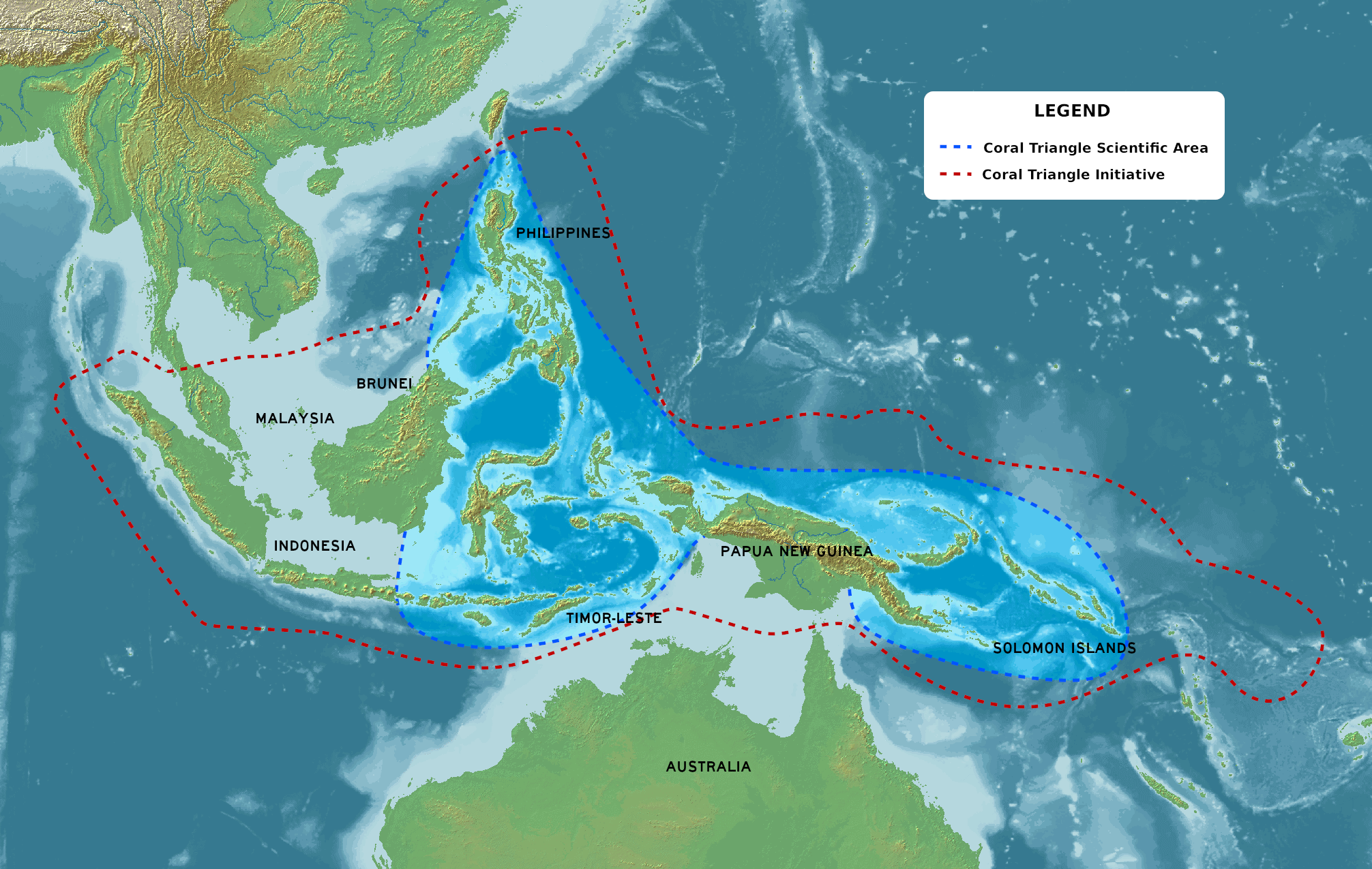
The Coral Triangle (CT) is a roughly triangular area in the tropical waters around the Philippines, Indonesia, Malaysia, Papua New Guinea, the Solomon Islands and Timor-Leste. This area contains at least 500 species of reef-building corals in each ecoregion.Veron et al. Unpublished data The Coral Triangle is located between the Pacific and Indian oceans and encompasses portions of two biogeographic regions: the Indonesian-Philippines Region, and the Far Southwestern Pacific Region.Veron, J.E.N. 1995. Corals in space and time: biogeography and evolution of the Scleractinia. UNSW Press, Sydney, Australia: xiii + 321 pp. As one of eight major coral reef zones in the world,Speers, A. E., Besedin, E. Y., Palardy, J. E., & Moore, C. (2016)Impacts of climate change and ocean acidification on coral reef fisheries: an integrated ecological–economic model Ecological economics, 128, 33-43. Retrieved 26 September 2020 the Coral Triangle is recognized as a global centre of marine biodivers ... [...More Info...] [...Related Items...] OR: [Wikipedia] [Google] [Baidu] |
Strait Of Makassar
A strait is an oceanic landform connecting two seas or two other large areas of water. The surface water generally flows at the same elevation on both sides and through the strait in either direction. Most commonly, it is a narrow ocean channel that lies between two land masses. Some straits are not navigable, for example because they are either too narrow or too shallow, or because of an unnavigable reef or archipelago. Straits are also known to be loci for sediment accumulation. Usually, sand-size deposits occur on both the two opposite strait exits, forming subaqueous fans or deltas. Terminology The terms '' channel'', ''pass'', or ''passage'' can be synonymous and used interchangeably with ''strait'', although each is sometimes differentiated with varying senses. In Scotland, ''firth'' or ''Kyle'' are also sometimes used as synonyms for strait. Many straits are economically important. Straits can be important shipping routes and wars have been fought for control of t ... [...More Info...] [...Related Items...] OR: [Wikipedia] [Google] [Baidu] |
Pangkajene And Islands Regency
The Pangkajene and Islands Regency (Indonesian: ''Kabupaten Pangkajene dan Kepulauan'', usually shortened to ''Pangkep''), ( mak, ᨈᨀᨒᨑ, Pangkajè’ne’, ) is a regency of South Sulawesi Province of Indonesia. The regency lies primarily on the mainland of Sulawesi's southern peninsula, but also includes the Spermonde Islands (''Kepulauan Spermonde'') off the west coast of that peninsula, as well as other small islands further west and southwest. The principal town lies at Pangkajene on Sulawesi, but there are a series of further towns like Lejang, Labakkang, Bontobonto and Segeri proceeding northwards from Pangkajene along the Trans-Sulawesi Highway. The total land area is 1,112.29 km2, and the population was 305,737 at the 2010 Census and 345,775 at the 2020 Census. Administrative Districts The Regency comprises thirteen administrative Districts (''Kecamatan''), tabulated below with their areas and their populations at the 2010 Census and the 2020 Census.Badan ... [...More Info...] [...Related Items...] OR: [Wikipedia] [Google] [Baidu] |
South Sulawesi
South Sulawesi ( id, Sulawesi Selatan) is a province in the southern peninsula of Sulawesi. The Selayar Islands archipelago to the south of Sulawesi is also part of the province. The capital is Makassar. The province is bordered by Central Sulawesi and West Sulawesi to the north, the Gulf of Bone and Southeast Sulawesi to the east, Makassar Strait to the west, and Flores Sea to the south. The 2010 census estimated the population as 8,032,551 which makes South Sulawesi the most populous province on the island (46% of the population of Sulawesi is in South Sulawesi), and the sixth most populous province in Indonesia. At the 2020 Census this had risen to 9,073,509,Badan Pusat Statistik, Jakarta, 2021. and the official estimate as at mid 2021 was 9,139,531. The main ethnic groups in South Sulawesi are the Buginese, Makassarese, Toraja, and Mandar. The economy of the province is based on agriculture, fishing, and mining of gold, magnesium, iron and other metals. The pinisi, a ... [...More Info...] [...Related Items...] OR: [Wikipedia] [Google] [Baidu] |
Makassar
Makassar (, mak, ᨆᨀᨔᨑ, Mangkasara’, ) is the capital of the Indonesian province of South Sulawesi. It is the largest city in the region of Eastern Indonesia and the country's fifth-largest urban center after Jakarta, Surabaya, Medan, and Bandung.Ministry of Internal AffairsRegistration Book for Area Code and Data of 2013/ref> The city is located on the southwest coast of the island of Sulawesi, facing the Makassar Strait. Throughout its history, Makassar has been an important trading port, hosting the center of the Gowa Sultanate and a Portuguese naval base before its conquest by the Dutch East India Company in the 17th century. It remained an important port in the Dutch East Indies, serving Eastern Indonesian regions with Makassarese fishers going as far south as the Australian coast. For a brief period after Indonesian independence, Makassar became the capital of the State of East Indonesia, during which an uprising occurred. The city's area is , a ... [...More Info...] [...Related Items...] OR: [Wikipedia] [Google] [Baidu] |
Sand Cay
A cay ( ), also spelled caye or key, is a small, low-elevation, sandy island on the surface of a coral reef. Cays occur in tropical environments throughout the Pacific, Atlantic, and Indian Oceans, including in the Caribbean and on the Great Barrier Reef and Belize Barrier Reef. Etymology The 1492 indigenous people of the Bahamas were called " Lucayan", an Anglicization of the Spanish ''Lucayos'', derived in turn from the Taíno ''Lukku-Cairi'' (which the people used for themselves), meaning "people of the islands". The Taíno word for "island", ''cairi'', became ''cayo'' in Spanish and "cay" in English (spelled "key" in American English, "caye" in Belizean English). Formation and composition A cay forms when ocean currents transport loose sediment across the surface of a reef to where the current slows or converges with another current, releasing its sediment load. Gradually, layers of deposited sediment build up on the reef surface – a '' depositional node''. Such no ... [...More Info...] [...Related Items...] OR: [Wikipedia] [Google] [Baidu] |


