|
Spanbroekmolen
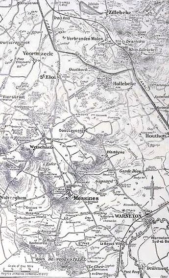
Spanbroekmolen is a small group of farms in Heuvelland, a municipality located in the Belgian province of West Flanders. The hamlet is sited on one of the highest points of the Messines Ridge, in between the villages of Kemmel, Wijtschate and Wulvergem. History Spanbroekmolen was named after a windmill that stood on the site for three centuries until it was ruined by the Germans on 1 November 1914. In World War I, the area was the site of intense and sustained fighting between German and British forces. Between 1914 and 1917, the Western Front ran through the area, and the original buildings were completely destroyed. Because of its strategic position on the Messines Ridge south of the Ypres Salient, the Germans used the site for a front-line fortification. As the Allied attacks along the Western Front became more formidable, the Germans added further defences and trench positions at Spanbroekmolen and connected their original lines with the neighbouring strongpoints, which wer ... [...More Info...] [...Related Items...] OR: [Wikipedia] [Google] [Baidu] |
Mines In The Battle Of Messines (1917)
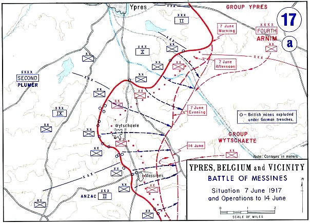
At the start of the Battle of Messines during the First World War, underground explosive charges were detonated by the British Second Army (General Sir Herbert Plumer) beneath the forward position of the German 4th Army near the village of Mesen (''Messines'' in French, historically used in English), in Belgian West Flanders. The mines, secretly planted by British tunnelling units, created craters and killed approximately 10,000 German soldiers. Their joint explosion ranks among the largest non-nuclear explosions of all time. The evening before the attack, General Sir Charles Harington, Chief of Staff of the Second Army, remarked to the press, "Gentlemen, I don’t know whether we are going to make history tomorrow, but at any rate we shall change geography". The Battle of Messines marked the zenith of mine warfare. On 10 August, the Royal Engineers fired the last British deep mine of the war, at Givenchy-en-Gohelle near Arras. Background British mining, 1915–1916 ... [...More Info...] [...Related Items...] OR: [Wikipedia] [Google] [Baidu] |
Tunnelling Companies Of The Royal Engineers
Royal Engineer tunnelling companies were specialist units of the Corps of Royal Engineers within the British Army, formed to dig attacking tunnels under enemy lines during the First World War. The stalemate situation in the early part of the war led to the deployment of tunnel warfare. After the first German Empire attacks on 21 December 1914, through shallow tunnels underneath no man's land and exploding ten mines under the trenches of the Indian Sirhind Brigade, the British began forming suitable units. In February 1915, eight Tunnelling Companies were created and operational in Flanders from March 1915. By mid-1916, the British Army had around 25,000 trained tunnellers, mostly volunteers taken from coal mining communities. Almost twice that number of "attached infantry" worked permanently alongside the trained miners acting as 'beasts of burden'. From the spring of 1917 the whole war became more mobile, with grand offensives at Arras, Messines and Passchendaele. There was ... [...More Info...] [...Related Items...] OR: [Wikipedia] [Google] [Baidu] |
Battle Of Messines (1917)
The Battle of Messines (7–14 June 1917) was an attack by the British Second Army (General Sir Herbert Plumer), on the Western Front, near the village of Messines (now Mesen) in West Flanders, Belgium, during the First World War. The Nivelle Offensive in April and May had failed to achieve its more grandiose aims, had led to the demoralisation of French troops and confounded the Anglo-French strategy for 1917. The attack forced the Germans to move reserves to Flanders from the Arras and Aisne fronts, relieving pressure on the French. The British tactical objective was to capture the German defences on the ridge, which ran from Ploegsteert Wood (Plugstreet to the British) in the south, through Messines and Wytschaete to Mt Sorrel, depriving the German 4th Army of the high ground. The ridge gave commanding views of the British defences and back areas of Ypres to the north, from which the British intended to conduct the Northern Operation, an advance to Passchendaele Ridge an ... [...More Info...] [...Related Items...] OR: [Wikipedia] [Google] [Baidu] |
Gas Attacks At Wulverghem
The Gas attacks at Wulverghem (30 April and 17 June 1916) were German cloud gas releases during the First World War on British troops in the municipality of Heuvelland, near Ypres in the Belgian province of West Flanders. The gas attacks were part of the sporadic fighting between battles in the Ypres Salient on the Western Front. The British Second Army held the ground from Messines Ridge northwards to Steenstraat and the divisions opposite the German XXIII Reserve Corps had received warnings of a gas attack. From 21 to 23 April, British artillery-fire exploded several gas cylinders in the German lines around Spanbroekmolen, which released greenish-yellow clouds. A gas alert was given on 25 April when the wind began to blow from the north-east and routine work was suspended; on 29 April, two German soldiers deserted and warned that an attack was imminent. Just after midnight on 30 April, the German attack began and over no man's land, a gas cloud drifted on the wind into the ... [...More Info...] [...Related Items...] OR: [Wikipedia] [Google] [Baidu] |
250th Tunnelling Company
The 250th Tunnelling Company was one of the tunnelling companies of the Royal Engineers created by the British Army during World War I. The tunnelling units were occupied in offensive and defensive mining involving the placing and maintaining of mines under enemy lines, as well as other underground work such as the construction of deep dugouts for troop accommodation, the digging of subways, saps (a narrow trench dug to approach enemy trenches), cable trenches and underground chambers for signals and medical services.The Tunnelling Companies RE , access date 25 April 2015 Background By January 1915 it had become evident to the BEF at the[...More Info...] [...Related Items...] OR: [Wikipedia] [Google] [Baidu] |
Heuvelland
Heuvelland () is a municipality located in the Belgian province of West Flanders. The municipality comprises the villages of Dranouter, Kemmel, De Klijte, Loker, Nieuwkerke, Westouter, Wijtschate and Wulvergem. Heuvelland is a thinly populated rural municipality, located between the small urban centres of Ypres and Poperinge and the metropolitan area of Kortrijk-Lille along the E17. On 1 January 2006 Heuvelland had a total population of 8,217. The total area is 94.24 km2 which gives a population density of 87 inhabitants per km2. The name ''heuvelland'' is Dutch meaning "hill country", as the municipality is characterized by the different hills on its territory. Geography Landscape The municipality is located in an area known as the West-Flemish Hills. The highest hill in Heuvelland is the Kemmelberg (156 m); followed by the Vidaigneberg (136 m), the Rodeberg (129 m), the Scherpenberg (125 m) and a lower hill in Wijtschate (82 m). On the border with France is the ... [...More Info...] [...Related Items...] OR: [Wikipedia] [Google] [Baidu] |
Kemmel
Heuvelland () is a municipality located in the Belgian province of West Flanders. The municipality comprises the villages of Dranouter, Kemmel, De Klijte, Loker, Nieuwkerke, Westouter, Wijtschate and Wulvergem. Heuvelland is a thinly populated rural municipality, located between the small urban centres of Ypres and Poperinge and the metropolitan area of Kortrijk-Lille along the E17. On 1 January 2006 Heuvelland had a total population of 8,217. The total area is 94.24 km2 which gives a population density of 87 inhabitants per km2. The name ''heuvelland'' is Dutch meaning "hill country", as the municipality is characterized by the different hills on its territory. Geography Landscape The municipality is located in an area known as the West-Flemish Hills. The highest hill in Heuvelland is the Kemmelberg (156 m); followed by the Vidaigneberg (136 m), the Rodeberg (129 m), the Scherpenberg (125 m) and a lower hill in Wijtschate (82 m). On the border with France is ... [...More Info...] [...Related Items...] OR: [Wikipedia] [Google] [Baidu] |
Wijtschate
Heuvelland () is a municipality located in the Belgian province of West Flanders. The municipality comprises the villages of Dranouter, Kemmel, De Klijte, Loker, Nieuwkerke, Westouter, Wijtschate and Wulvergem. Heuvelland is a thinly populated rural municipality, located between the small urban centres of Ypres and Poperinge and the metropolitan area of Kortrijk-Lille along the E17. On 1 January 2006 Heuvelland had a total population of 8,217. The total area is 94.24 km2 which gives a population density of 87 inhabitants per km2. The name ''heuvelland'' is Dutch meaning "hill country", as the municipality is characterized by the different hills on its territory. Geography Landscape The municipality is located in an area known as the West-Flemish Hills. The highest hill in Heuvelland is the Kemmelberg (156 m); followed by the Vidaigneberg (136 m), the Rodeberg (129 m), the Scherpenberg (125 m) and a lower hill in Wijtschate (82 m). On the border with France is th ... [...More Info...] [...Related Items...] OR: [Wikipedia] [Google] [Baidu] |
Ypres Salient
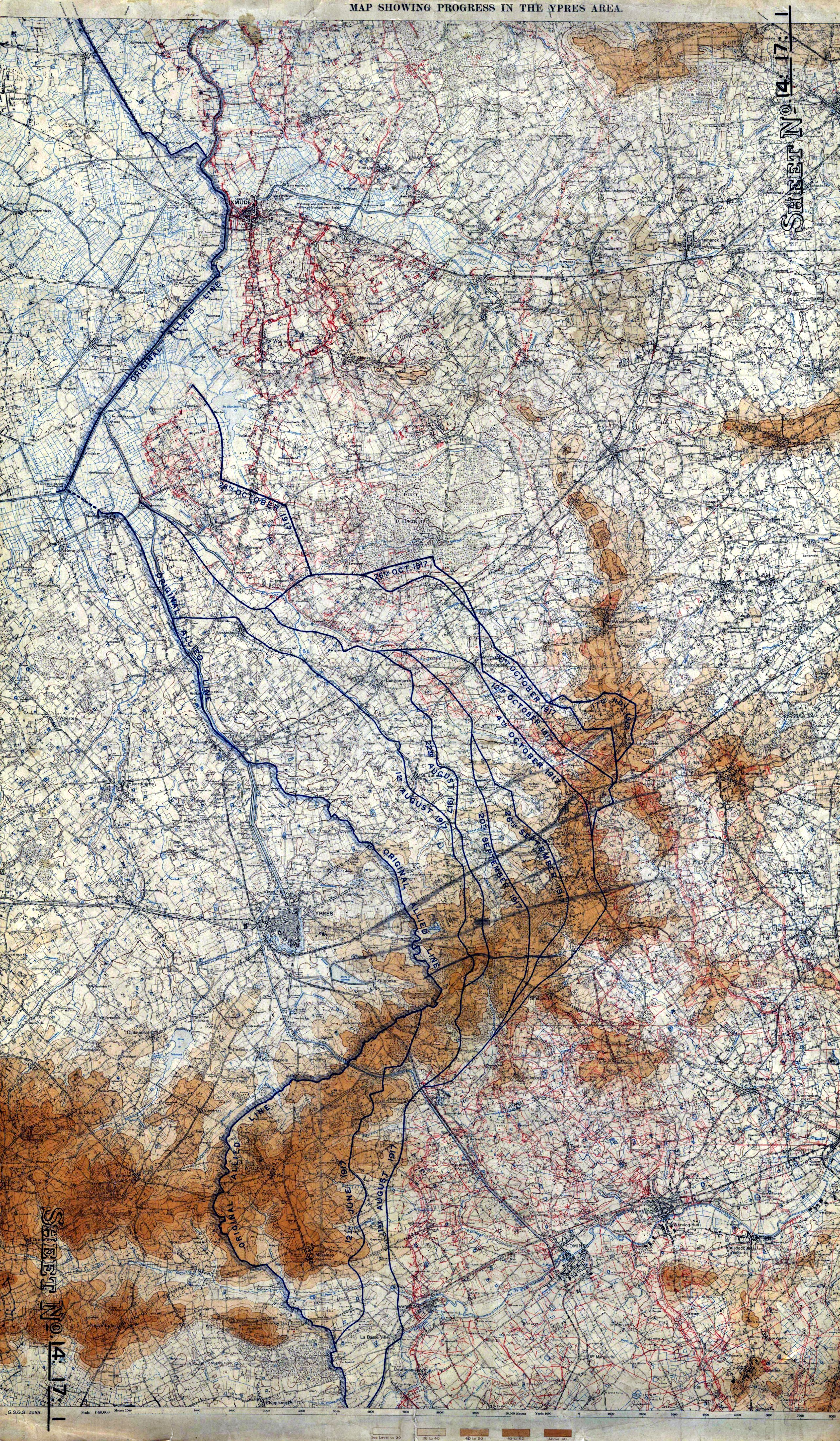
The Ypres Salient around Ypres in Belgium was the scene of several battles and an extremely important part of the Western front during the First World War. Ypres district Ypres lies at the junction of the Ypres–Comines Canal and the Ieperlee. The city is overlooked by Kemmel Hill in the south-west and from the east by low hills running south-west to north-east with Wytschaete ( Wijtschate), Hill 60 to the east of Verbrandenmolen, Hooge, Polygon Wood and Passchendaele ( Passendale). The high point of the ridge is at Wytschaete, from Ypres, while at Hollebeke the ridge is distant and recedes to at Polygon Wood. Wytschaete is about above the plain; on the Ypres–Menin road at Hooge, the elevation is about and at Passchendaele. The rises are slight, apart from the vicinity of Zonnebeke, which has a From Hooge and to the east, the slope is near Hollebeke, it is heights are subtle but have the character of a saucer lip around Ypres. The main ridge has spurs sloping e ... [...More Info...] [...Related Items...] OR: [Wikipedia] [Google] [Baidu] |
Cyril Gordon Martin
Brigadier Cyril Gordon Martin VC CBE DSO (19 December 1891 – 14 August 1980) was a British Army officer and an English recipient of the Victoria Cross (VC), the highest and most prestigious award for gallantry in the face of the enemy that can be awarded to British and Commonwealth forces. Martin was educated at Clifton College He was 23 years old, and a lieutenant in the 56th Field Company, Corps of Royal Engineers, British Army during the First World War when the following deed took place for which he was awarded the VC. On 12 March 1915 at Spanbroekmolen on the Messines Ridge, Belgium, Lieutenant Martin volunteered to lead a small bombing party against a section of the enemy trenches which was holding up the advance. Before he started he was wounded, but, taking no notice, he carried on with the attack which was completely successful. He and his small party held the trench against all counter-attacks for two and a half hours until a general withdrawal was ordered. He late ... [...More Info...] [...Related Items...] OR: [Wikipedia] [Google] [Baidu] |
Second Army (United Kingdom)
The British Second Army was a field army active during the First and Second World Wars. During the First World War the army was active on the Western Front throughout most of the war and later active in Italy. During the Second World War the army was the main British contribution to the Normandy landings on 6 June 1944 and advance across Europe. First World War The Second Army was part of the British Army formed on 26 December 1914, when the British Expeditionary Force was split in two due to becoming too big to control its subordinate formations. The army controlled both III Corps and IV Corps. Second Army spent most of the war positioned around the Ypres salient, but was redeployed to Italy as part of the Italian Expeditionary Force between November 1917 and March 1918. In 1919 it was reconstituted as the British Army of the Rhine.Edmonds (1987) Commanders * 1914–1915 General Sir Horace Smith-Dorrien * 1915–1917 General Sir Herbert Plumer * 1917–1918 General Si ... [...More Info...] [...Related Items...] OR: [Wikipedia] [Google] [Baidu] |


