|
Southern Rocky Mountain Front
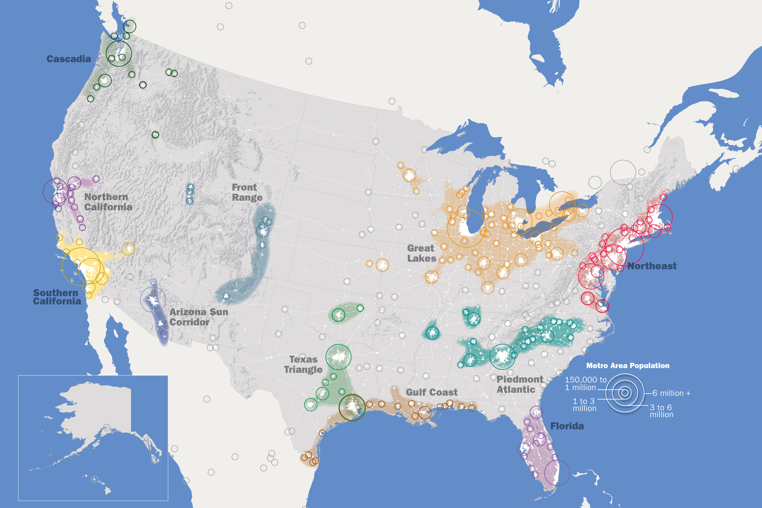
The Southern Rocky Mountain Front is a megaregion of the United States, otherwise known as a megalopolis, with population centers consisting mainly of the Front Range Urban Corridor and the Albuquerque–Santa Fe–Las Vegas combined statistical area, located along the eastern and southern face of the Southern Rocky Mountains in the U.S. states of Wyoming, Colorado, and New Mexico. The region comprises the southern portion of the Rocky Mountain Front geographic region of Canada and the United States, extending into the Southwestern United States. The Southern Rocky Mountain Front had a population of 5,467,633 according to the 2010 United States census. The region is one of the fastest-growing regions in the United States, and its population is projected to grow by 87% to 10,222,370 by 2050. In 2005 the GDP of the region was $229,202,000,000 making up 2% of the United States GDP. Extent The Southern Rocky Mountain Front stretches from Albuquerque, New Mexico, north along Int ... [...More Info...] [...Related Items...] OR: [Wikipedia] [Google] [Baidu] |
Megaregions Of The United States
Megaregions of the United States are generally understood to be regions in the U.S. that contain two or more roughly adjacent urban metropolitan areas that, through commonality of systems—of transport, economy, resources, and ecologies—experience blurred boundaries between the urban centers, such that perceiving and acting as if they are a continuous urban area is, for the purposes of policy coordination, of practical value. The antecedent term, with which "megaregions" is synonymous, is megalopolis, which was coined in relation to the Boston through Washington, D.C., corridor in the Atlantic Northeast, by Jean Gottmann in the mid-twentieth century. ''America 2050'', a project of the Regional Plan Association, lists 11 megaregions encompassing urban regions in the United States, Canada, and Mexico (e.g., the Great Lakes and Northeast Megaregions). As of December 2000, these clustered networks of American cities contained an estimated total population exceeding 280 million ... [...More Info...] [...Related Items...] OR: [Wikipedia] [Google] [Baidu] |
United States Census Bureau
The United States Census Bureau (USCB), officially the Bureau of the Census, is a principal agency of the U.S. Federal Statistical System, responsible for producing data about the American people and economy An economy is an area of the production, distribution and trade, as well as consumption of goods and services. In general, it is defined as a social domain that emphasize the practices, discourses, and material expressions associated with t .... The Census Bureau is part of the United States Department of Commerce, U.S. Department of Commerce and its Director of the United States Census Bureau, director is appointed by the President of the United States. The Census Bureau's primary mission is conducting the United States census, U.S. census every ten years, which allocates the seats of the U.S. House of Representatives to the U.S. state, states based on their population. The bureau's various censuses and surveys help allocate over $675 billion in federal funds e ... [...More Info...] [...Related Items...] OR: [Wikipedia] [Google] [Baidu] |
South Central Colorado Urban Area
240px, An enlargeable map of the four-county South Central Colorado Urban Area The South Central Colorado Urban Area comprises the Colorado Springs Metropolitan Statistical Area, the Pueblo Metropolitan Statistical Area, and the Cañon City Micropolitan Statistical Area in the central and south central region of the State of Colorado. With the exception of northern Teller County and small portions of northern El Paso County, the entire South Central Colorado Urban Area is drained by the Arkansas River and its tributaries. The South Central Colorado Urban Area is the southernmost of the three primary subregions of the Front Range Urban Corridor. The South Central Colorado Urban Area had a population of 851,500 at the 2010 United States Census, and increase of 17.43% from the 2000 United States Census. In 2010, 16.93% of Coloradans lived in the South Central Colorado Urban Area. Extent Municipalities Constituent jurisdictions The South Central Colorado Urban Area inc ... [...More Info...] [...Related Items...] OR: [Wikipedia] [Google] [Baidu] |
Santa Fe, NM Metropolitan Statistical Area
Santa Fe County ( es, Condado de Santa Fe; meaning ''Holy faith'' in Spanish) is located in the U.S. state of New Mexico. As of the 2010 census, the population was 144,170, making it New Mexico's third-most populous county, after Bernalillo County and Doña Ana County. Its county seat is Santa Fe, the state capital. Santa Fe County includes the Santa Fe metropolitan statistical area, which is also included in the Albuquerque–Santa Fe–Las Vegas combined statistical area. Geography According to the U.S. Census Bureau, the county has a total area of , of which is land and (0.08%) is water. It is the fifth-smallest county in New Mexico by area. The highest point in the county is the summit of Santa Fe Baldy at . It is drained by the Rio Grande and several of its small tributaries. Adjacent counties * Rio Arriba County - north * Mora County - northeast * San Miguel County - east * Torrance County - south * Bernalillo County - southwest * Sandoval County - west * Los Alamos ... [...More Info...] [...Related Items...] OR: [Wikipedia] [Google] [Baidu] |
Albuquerque, NM Metropolitan Statistical Area
The Albuquerque Metropolitan Statistical Area, sometimes referred to as Tiguex (named after the Southern Tiwa), is a metropolitan area in central New Mexico centered on the city of Albuquerque. The metro comprises four counties: Bernalillo, Sandoval, Torrance, and Valencia. As of the 2010 United States Census, the MSA had a population of 887,077. The population is estimated to be 923,630 as of July 1, 2020, making Greater Albuquerque the 61st-largest MSA in the nation. The Albuquerque MSA forms a part of the larger Albuquerque–Santa Fe–Las Vegas combined statistical area with a 2020 estimated population of 1,165,181, ranked 49th-largest in the country. History It was the center of the Aztec legend of the Seven Cities of Gold, sometimes called the "cities of Cibola". The Tiguex Province of Santa Fe de Nuevo México was named after the Southern Tiwa speaking Puebloans in the area, they inhabited the area along with the Jemez and Keres people. The area between Bernalillo a ... [...More Info...] [...Related Items...] OR: [Wikipedia] [Google] [Baidu] |
Cañon City, CO Micropolitan Statistical Area
A canyon (from ; archaic British English spelling: ''cañon''), or gorge, is a deep cleft between escarpments or cliffs resulting from weathering and the erosive activity of a river over geologic time scales. Rivers have a natural tendency to cut through underlying surfaces, eventually wearing away rock layers as sediments are removed downstream. A river bed will gradually reach a baseline elevation, which is the same elevation as the body of water into which the river drains. The processes of weathering and erosion will form canyons when the river's headwaters and estuary are at significantly different elevations, particularly through regions where softer rock layers are intermingled with harder layers more resistant to weathering. A canyon may also refer to a rift between two mountain peaks, such as those in ranges including the Rocky Mountains, the Alps, the Himalayas or the Andes. Usually, a river or stream carves out such splits between mountains. Examples of mountain-type ca ... [...More Info...] [...Related Items...] OR: [Wikipedia] [Google] [Baidu] |
Cheyenne, WY Metropolitan Statistical Area
Laramie County is a county located at the southeast corner of the state of Wyoming. As of the 2020 United States Census, the population was 100,512 or 17.4% of the state's total 2020 population, making it the most populous county in Wyoming, but the least populous county in the United States to be the most populous in its state. The county seat is Cheyenne, the state capital. The county lies west of the Nebraska state line and north of the Colorado state line. Laramie County comprises the Cheyenne, WY Metropolitan Statistical Area. The city of Laramie, Wyoming, is in neighboring Albany County. History Laramie County was originally created in 1867 as a county within the Dakota Territory. The county was named for Jacques La Ramee, a French-Canadian fur-trader. In 1867, a portion of Laramie County was annexed to create Sweetwater County; in 1868; further annexations occurred to create Albany County and Carbon County. Laramie County became a county in the Wyoming Territor ... [...More Info...] [...Related Items...] OR: [Wikipedia] [Google] [Baidu] |
Greeley, CO Metropolitan Statistical Area
Weld County is a county located in the U.S. state of Colorado. As of the 2020 census, the population was 328,981. The county seat is Greeley. Weld County comprises the Greeley, CO Metropolitan Statistical Area, which is included in the Denver–Aurora, CO Combined Statistical Area. History On May 30, 1854, the Kansas–Nebraska Act created the Nebraska Territory and the Kansas Territory, divided by the Parallel 40° North ( Baseline Road or County Line Road or Weld County Road 2 in the future Weld County). Present-day Weld County, Colorado, lay in the southwestern portion of the Nebraska Territory, bordering the Kansas Territory. In July 1858, gold was discovered along the South Platte River in Arapahoe County, Kansas Territory. This discovery precipitated the Pike's Peak Gold Rush. Many residents of the mining region felt disconnected from the remote territorial governments of Kansas and Nebraska, so they voted to form their own Territory of Jefferson on October 24, ... [...More Info...] [...Related Items...] OR: [Wikipedia] [Google] [Baidu] |
Fort Collins, CO Metropolitan Statistical Area
Larimer County is a county located in the U.S. state of Colorado. As of the 2020 census, the population was 359,066. The county seat and most populous city is Fort Collins. The county was named for William Larimer, Jr., the founder of Denver. Larimer County comprises the Fort Collins, CO Metropolitan Statistical Area. The county is located at the northern end of the Front Range, at the edge of the Colorado Eastern Plains along the border with Wyoming. History Larimer County was created in 1861, and was named after General William Larimer. Unlike that of much of Colorado, which was founded on the mining of gold and silver, the settlement of Larimer County was based almost entirely on agriculture, an industry that few thought possible in the region during the initial days of the Colorado Gold Rush. The mining boom almost entirely passed the county by. It would take the introduction of irrigation to the region in the 1860s to bring the first widespread settlement to the area. E ... [...More Info...] [...Related Items...] OR: [Wikipedia] [Google] [Baidu] |
Colorado Springs, CO Metropolitan Statistical Area
Colorado (, other variants) is a state in the Mountain West subregion of the Western United States. It encompasses most of the Southern Rocky Mountains, as well as the northeastern portion of the Colorado Plateau and the western edge of the Great Plains. Colorado is the eighth most extensive and 21st most populous U.S. state. The 2020 United States census enumerated the population of Colorado at 5,773,714, an increase of 14.80% since the 2010 United States census. The region has been inhabited by Native Americans and their ancestors for at least 13,500 years and possibly much longer. The eastern edge of the Rocky Mountains was a major migration route for early peoples who spread throughout the Americas. "''Colorado''" is the Spanish adjective meaning "ruddy", the color of the Fountain Formation outcroppings found up and down the Front Range of the Rocky Mountains. The Territory of Colorado was organized on February 28, 1861, and on August 1, 1876, U.S. President Ulysse ... [...More Info...] [...Related Items...] OR: [Wikipedia] [Google] [Baidu] |


.jpg)


