|
Southdowns Airport
Southdowns Airport is an airport serving Kitwe, a city in the Copperbelt Province in Zambia. The airport is located in Kalulushi District, in the countryside southwest of Kitwe and south-east of Kalulushi. The Ndola VOR-DME (Ident: VND) is located east of the airport. The Southdowns non-directional beacon (Ident: KT) is located on the field. See also *Transport in Zambia *List of airports in Zambia This is a list of airports in Zambia, sorted by location. Zambia, officially the Republic of Zambia, is a landlocked country in Southern Africa. The neighboring countries are the Democratic Republic of the Congo to the north, Tanzania to t ... References External linksOpenStreetMap - Southdowns Airport * Airports in Zambia [...More Info...] [...Related Items...] OR: [Wikipedia] [Google] [Baidu] |
Kalulushi
Kalulushi is a town in the Copperbelt Province in north central Zambia. It is located on the M18 Road, just west of Kitwe. Municipal (district) population 75,806 at the 2000 census. Kalulushi emerged as a planned company town with the development of mining Companies in the mid-20th century - initially housing the main offices for the Zambia Consolidated Copper Mines. Economic activity in Kalulushi (as well as the surrounding area) declined severely with the closure of 2 Shaft and 7 Shaft Mining sites. There is a famous story of the origin of the name Kalulushi. The story goes like this. Two gentlemen went hunting for rabbits. Rabbits, in the local Lamba language, are referred to as "kalulu." During their hunt they eventually spotted one rabbit. One of the gentlemen in excitement called out "kalulu!". The other gentlemen quietly told his friend, "shhhh" in order to avoid alarming the rabbit and prevent the rabbit from running away. So that's how the name Kalulushi came about. And so ... [...More Info...] [...Related Items...] OR: [Wikipedia] [Google] [Baidu] |
Kitwe
Kitwe is the third largest city in terms of infrastructure development (after Lusaka and Ndola) and second largest city in terms of size and population (after Lusaka) in Zambia. With a population of 517,543 (''2010 census provisional'') Kitwe is one of the most developed commercial and industrial areas in the nation, alongside Ndola and Lusaka. It has a complex of mines on its north-western and western edges.Google Earth accessed 2007. Kitwe is located in the Copperbelt Province and is made up of s and suburban areas including Parklands, Riverside, Buchi, Ch ... [...More Info...] [...Related Items...] OR: [Wikipedia] [Google] [Baidu] |
Chambishi
Chambishi is a town in Kalulushi District in the Copperbelt Province of Zambia. According to the 2021 Census its population stands at slightly above 11,000. It is located on the T3 Road (Kitwe-Chingola Dual Carriageway) between the cities of Kitwe and Chingola. It was re-established in 1963 as a company township for the mine workers of Chambishi Mine which was under Chibuluma Mine of Kalulushi. This was after an announcement by Sir Ronald Prain, Chairman of Roan Selection Trust, in May 1962 that the company was going to open up the Chambishi open pit-pit mine at a cost of 7.5 million British Pounds. Chambishi has been under civic administration of Kalulushi Municipal Council from 1963, another mining town on the Copperbelt Province of Zambia. Etymology The name Chambishi comes from two Lamba words "Cha" and "mbishi". Cha means "belonging to" or "an area of" while "mbishi" is a Lamba word for a zebra. The area was home to larger herds of zebras a century ago. Therefore, Ch ... [...More Info...] [...Related Items...] OR: [Wikipedia] [Google] [Baidu] |
Copperbelt Province
Copperbelt Province is a province in Zambia which covers the mineral-rich Copperbelt, and farming and bush areas to the south. It was the backbone of the Northern Rhodesian economy during British colonial rule and fuelled the hopes of the immediate post-independence period, but its economic importance was severely damaged by a crash in global copper prices in 1973. The province adjoins the Haut-Katanga province of the Democratic Republic of the Congo, which is similarly mineral-rich. The main cities of the Copperbelt are Kitwe, Ndola, Mufulira, Luanshya, Chingola, Kalulushi and Chililabombwe. Roads and rail links extend north into the Congo to Lubumbashi, but the Second Congo War brought economic contact between the two countries to a standstill, now recovering. It is informally referred to at times as 'Copala' or 'Kopala', invoking the vernacular-like term of the mineral copper that is mined in the province. Demographics As per the 2010 Zambian census, Copperbelt Provinc ... [...More Info...] [...Related Items...] OR: [Wikipedia] [Google] [Baidu] |
Zambia
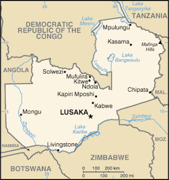
Zambia (), officially the Republic of Zambia, is a landlocked country at the crossroads of Central, Southern and East Africa, although it is typically referred to as being in Southern Africa at its most central point. Its neighbours are the Democratic Republic of the Congo to the north, Tanzania to the northeast, Malawi to the east, Mozambique to the southeast, Zimbabwe and Botswana to the south, Namibia to the southwest, and Angola to the west. The capital city of Zambia is Lusaka, located in the south-central part of Zambia. The nation's population of around 19.5 million is concentrated mainly around Lusaka in the south and the Copperbelt Province to the north, the core economic hubs of the country. Originally inhabited by Khoisan peoples, the region was affected by the Bantu expansion of the thirteenth century. Following the arrival of European explorers in the eighteenth century, the British colonised the region into the British protectorates of Barotseland-No ... [...More Info...] [...Related Items...] OR: [Wikipedia] [Google] [Baidu] |
Kalulushi District
Kalulushi District is a district of Zambia, located in Copperbelt Province. The capital lies at Kalulushi Kalulushi is a town in the Copperbelt Province in north central Zambia. It is located on the M18 Road, just west of Kitwe. Municipal (district) population 75,806 at the 2000 census. Kalulushi emerged as a planned company town with the development .... As of the 2000 Zambian Census, the district had a population of 75,806 people. References Districts of Copperbelt Province Kalulushi District {{Zambia-geo-stub ... [...More Info...] [...Related Items...] OR: [Wikipedia] [Google] [Baidu] |
VOR-DME
In radio navigation, a VOR/DME is a radio beacon that combines a VHF omnidirectional range (VOR) with a distance-measuring equipment (DME). The VOR allows the receiver to measure its bearing to or from the beacon, while the DME provides the slant distance between the receiver and the station. Together, the two measurements allow the receiver to compute a position fix. The VOR system was first introduced in the 1930s, but didn't enter significant commercial use until the early 1950s. It became much more practical with the introduction of low-cost Solid state (electronics), solid state receivers in the 1960s. DME was a modification of World War II-era navigation systems like Gee-H, and began development in 1946. Like VOR, it only became practical with the introduction of solid state receivers during the 1960s. During the mid-1960s, ICAO began the process of introducing a standardized radio navigation system for medium-area coverage on the order of a few hundred kilometres. ... [...More Info...] [...Related Items...] OR: [Wikipedia] [Google] [Baidu] |
Non-directional Beacon
A non-directional beacon (NDB) or non-directional radio beacon is a radio beacon which does not include directional information. Radio beacons are radio transmitters at a known location, used as an aviation or marine navigational aid. NDB are in contrast to directional radio beacons and other navigational aids, such as low-frequency radio range, VHF omnidirectional range (VOR) and tactical air navigation system (TACAN). NDB signals follow the curvature of the Earth, so they can be received at much greater distances at lower altitudes, a major advantage over VOR. However, NDB signals are also affected more by atmospheric conditions, mountainous terrain, coastal refraction and electrical storms, particularly at long range. The system, developed by United States Air Force (USAF) Captain Albert Francis Hegenberger, was used to fly the world's first instrument approach on May 9, 1932. Types of NDBs NDBs used for aviation are standardised by International Civil Aviation Orga ... [...More Info...] [...Related Items...] OR: [Wikipedia] [Google] [Baidu] |
Transport In Zambia
This article is about the transport in Zambia. Railway There is a total of 2,157 km (2008) of railway track in Zambia. Principal lines * Zambia Railways Limited (ZRL) – narrow gauge, 846 km Kitwe-Ndola-New Kapiri Mposhi-Kabwe-Lusaka-Livingstone-Zimbabwe with several freight branches mostly in the Copperbelt totalling 427 km including to DR Congo. Passenger services between Kitwe and Livingstone only. * TAZARA Railway – narrow gauge, 891 km in Zambia: New Kapiri Mposhi- Mpika- Kasama- Dar es Salaam Notable Branch lines * Maamba Colliery Railway, Choma to Masuka, built to carry coal. * The Mulobezi Railway (also known as Zambezi Sawmills Railway) is a narrow gauge line constructed to carry timber from Mulobezi to Livingstone. Has been reported at various times as defunct, currently listed in Railtracker (see 'Railway Network Map' below) but operating status not confirmed. * Mulungushi Commuter Line, later Njanji Commuter Line managed by ZRL, ope ... [...More Info...] [...Related Items...] OR: [Wikipedia] [Google] [Baidu] |
List Of Airports In Zambia
This is a list of airports in Zambia, sorted by location. Zambia, officially the Republic of Zambia, is a landlocked country in Southern Africa. The neighboring countries are the Democratic Republic of the Congo to the north, Tanzania to the northeast, Malawi to the east, Mozambique, Zimbabwe, Botswana and Namibia to the south, and Angola to the west. Zambia is divided into ten provinces. The capital city is Lusaka. __NOTOC__ Airports Airport names shown in bold indicate the airport has scheduled service on commercial airlines. See also * Department of Civil Aviation of Zambia * Transport in Zambia * List of Zambian airports by ICAO code * Wikipedia: WikiProject Aviation/Airline destination lists: Africa#Zambia References * * - includes IATA codes Great Circle Mapper: Airports in Zambia- IATA and ICAO codes {{Africa in topic, List of airports in, state=collapsed Zambia Airports Airports An airport is an aerodrome with extended fa ... [...More Info...] [...Related Items...] OR: [Wikipedia] [Google] [Baidu] |
Buildings And Structures In Copperbelt Province
A building, or edifice, is an enclosed structure with a roof and walls standing more or less permanently in one place, such as a house or factory (although there's also portable buildings). Buildings come in a variety of sizes, shapes, and functions, and have been adapted throughout history for a wide number of factors, from building materials available, to weather conditions, land prices, ground conditions, specific uses, prestige, and aesthetic reasons. To better understand the term ''building'' compare the list of nonbuilding structures. Buildings serve several societal needs – primarily as shelter from weather, security, living space, privacy, to store belongings, and to comfortably live and work. A building as a shelter represents a physical division of the human habitat (a place of comfort and safety) and the ''outside'' (a place that at times may be harsh and harmful). Ever since the first cave paintings, buildings have also become objects or canvasses of much artist ... [...More Info...] [...Related Items...] OR: [Wikipedia] [Google] [Baidu] |


.jpg)


