|
South Kempsey, New South Wales
South Kempsey is a suburb of Kempsey in the Kempsey Shire, New South Wales, Australia. They are separated by the Macleay River The Macleay River is a river that spans the Northern Tablelands and Mid North Coast districts of New South Wales, Australia. Course and features Formed by the confluence of the Gara River, Salisbury Waters and Bakers Creek, the Macleay River .... The 2016 census listed 2302 persons within the South Kempsey area. Heritage listings Kempsey has a number of heritage-listed sites, including: * North Coast railway: Macleay River railway bridge References {{reflist Kempsey Shire ... [...More Info...] [...Related Items...] OR: [Wikipedia] [Google] [Baidu] |
Suburbs And Localities (Australia)
Suburbs and localities are the names of geographic subdivisions in Australia, used mainly for address purposes. The term locality is used in rural areas, while the term suburb A suburb (more broadly suburban area) is an area within a metropolitan area, which may include commercial and mixed-use, that is primarily a residential area. A suburb can exist either as part of a larger city/urban area or as a separate ... is used in urban areas. Australian postcodes closely align with the boundaries of localities and suburbs. This Australian usage of the term "suburb" differs from common American and British usage, where it typically means a smaller, frequently separate residential community outside, but close to, a larger city. The Australian usage is closer to the American or British use of "district" or "neighbourhood", and can be used to refer to any portion of a city. Unlike the use in British or American English, this term can include inner-city, outer-metropolitan ... [...More Info...] [...Related Items...] OR: [Wikipedia] [Google] [Baidu] |
Kempsey, New South Wales
Kempsey is a town in the Mid North Coast region of New South Wales, Australia and is the council seat for Kempsey Shire. It is located roughly 16.5 kilometres inland from the coast of the Pacific Ocean, on the Macleay Valley Way near where the Pacific Highway and the North Coast railway line cross the Macleay River. It is roughly 430 kilometres north of Sydney. As of June 2018 Kempsey had a population of 15,309 (2018). Estimated resident population, 30 June 2018. History At the dawn of white occupation the town lay within the area of the Djangadi people's lands. An Aboriginal presence has been attested archaeologically to go back at least 4,000 years, according to the analysis of the materials excavated at the Clybucca midden, a site which the modern-day descendants of the Djangadi and Gumbaynggirr claim native title rights. In the Clybucca area are ancient camp sites with shell beds in the form of mounds which are up to 2 metres (6 ft 7 in) high. Middens are attes ... [...More Info...] [...Related Items...] OR: [Wikipedia] [Google] [Baidu] |
Kempsey Shire
Kempsey Shire is a Local government in Australia, local government area in the Mid North Coast region of New South Wales, Australia. The shire services an area of and is located on the Pacific Highway (Australia), Pacific Highway and the North Coast railway line, New South Wales, North Coast railway line. Kempsey Shire was formed on 1 October 1975 by the amalgamation of the former Kempsey Municipality and the former Macleay Shire. At the , Kempsey Shire had a high proportion of Aboriginal and Torres Strait Islander people residing within its boundaries; being 11.1 per cent of the resident population, more than four times the national and state Median, averages of 2.5 per cent. The shire also contains a coastal strip that was identified in 2007, and confirmed in 2015, as one of the most SEIFA, socially disadvantaged areas in Australia. The Mayor of the Kempsey Shire is Leo Hauville, an Independent (politician), independent politician. Suburbs * Aldavilla, New South Wales, Alda ... [...More Info...] [...Related Items...] OR: [Wikipedia] [Google] [Baidu] |
New South Wales
) , nickname = , image_map = New South Wales in Australia.svg , map_caption = Location of New South Wales in AustraliaCoordinates: , subdivision_type = Country , subdivision_name = Australia , established_title = Before federation , established_date = Colony of New South Wales , established_title2 = Establishment , established_date2 = 26 January 1788 , established_title3 = Responsible government , established_date3 = 6 June 1856 , established_title4 = Federation , established_date4 = 1 January 1901 , named_for = Wales , demonym = , capital = Sydney , largest_city = capital , coordinates = , admin_center = 128 local government areas , admin_center_type = Administration , leader_title1 = Monarch , leader_name1 = Charles III , leader_title2 = Governor , leader_name2 = Margaret Beazley , leader_title3 = Premier , leader_name3 = Dominic Perrottet ( Liberal) , national_representation = Parliament of Australia , national_representation_type1 = Sen ... [...More Info...] [...Related Items...] OR: [Wikipedia] [Google] [Baidu] |
Macleay River
The Macleay River is a river that spans the Northern Tablelands and Mid North Coast districts of New South Wales, Australia. Course and features Formed by the confluence of the Gara River, Salisbury Waters and Bakers Creek, the Macleay River rises below Blue Nobby Mountain, east of Uralla within the Great Dividing Range. The river flows in a meandering course generally east by south, joined by twenty-six tributaries including the Apsley, Chandler, and Dyke rivers and passing through a number of spectacular gorges and waterfalls in Cunnawarra National Park and Oxley Wild Rivers National Park, before reaching its mouth at the Tasman Sea, near South West Rocks. The river descends over its course. The river flows through the town of Kempsey. At the river is traversed by the Pacific Highway via the Macleay River Bridge ( Dhanggati language: ''Yapang gurraarrbang gayandugayigu''). At the time of its official opening in 2013, the bridge was the longest road bridge in Aust ... [...More Info...] [...Related Items...] OR: [Wikipedia] [Google] [Baidu] |
North Coast Railway Line, New South Wales
The North Coast Line is the primary rail route in the Mid North Coast and Northern Rivers regions of New South Wales, Australia, and forms a major part of the Sydney–Brisbane rail corridor. The line begins at Maitland and ends at Roma Street railway station in Brisbane, although freight services terminate at the yard at Acacia Ridge on the outskirts of Brisbane. Along the way, the railway passes through the towns of Dungog, Gloucester, Wingham, Taree, Kendall, Wauchope, Kempsey, Macksville, Nambucca Heads, Urunga, Sawtell, Coffs Harbour, Grafton, Casino and Kyogle. After the standard gauge line ends at Acacia Ridge, it forms a dual gauge line into Brisbane, running alongside parts of the Beenleigh railway line. Since the Main Northern Line was closed north of Armidale in 1988, the North Coast line is now the only route between Sydney and Queensland. With the closure of former branches to Dorrigo (1972) and Murwillumbah (2004) there are no operating branches off the l ... [...More Info...] [...Related Items...] OR: [Wikipedia] [Google] [Baidu] |
Macleay River Railway Bridge, Kempsey
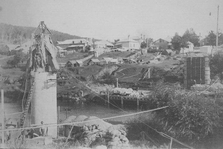
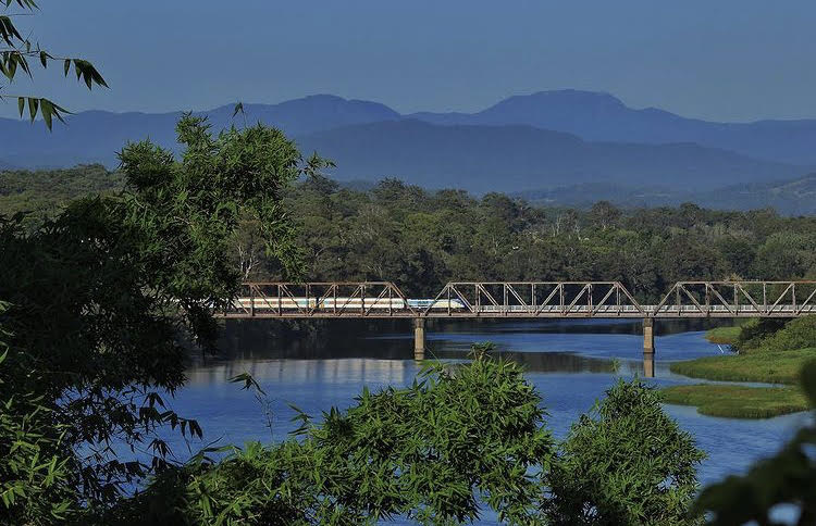
The Macleay River Railway Bridge is a heritage-listed railway bridge that carries the North Coast railway line across the Macleay River from Kempsey to South Kempsey in New South Wales, Australia. History The Macleay River Railway Bridge opened on 3 December 1917 with the extension of the North Coast railway line from Wauchope to Kempsey. The steelwork was made at the Walsh Island Dockyard & Engineering Works, Newcastle and transported to Kempsey by sea. The bridge was damaged in floods in 1949 and 1950. It was repaired with the timber trestles replaced by 1880s vintage wrought iron Warren trusses formerly used on the Main Western railway line between Parramatta and Penrith. It was proposed to replace the entire bridge, but this proposal had been abandoned by 1953. In 1966 the bridge spans were raised by due to the 1950s floods, with new pre-cast concrete approaches constructed.. Description The bridge is a steel Pratt truss bridge with consisting of three steel s ... [...More Info...] [...Related Items...] OR: [Wikipedia] [Google] [Baidu] |


