|
South-up Map Orientation
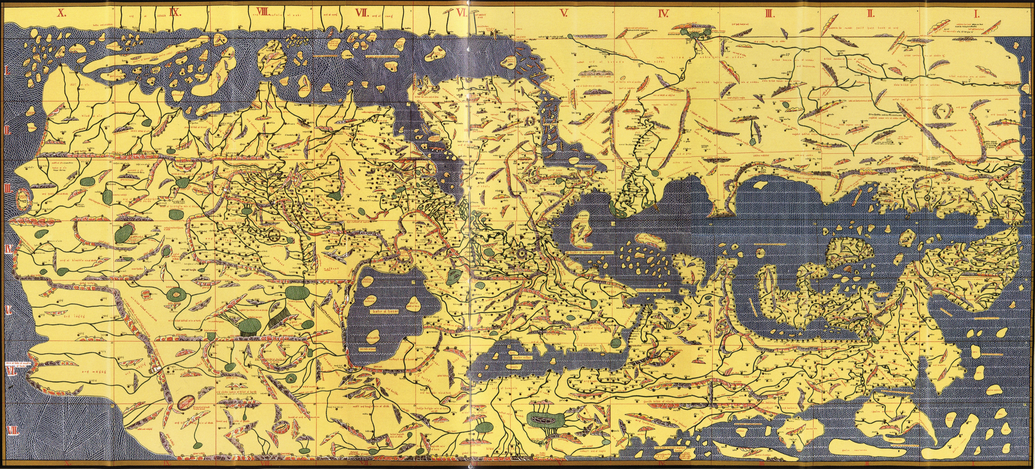
South-up map orientation is the orientation of a map with south up, at the top of the map, amounting to a 180-degree rotation of the map from the standard convention of north-up. Maps in this orientation are sometimes called upside-down maps or reversed maps. Psychological significance Research suggests that north-south positions on maps have psychological consequences. In general, north is associated with richer people, more expensive real estate, and higher altitude, while south is associated with poorer people, cheaper prices, and lower altitude (the "north-south bias"). When participants were presented with south-up oriented maps, this north-south bias disappeared. Researchers posit that the observed association between map-position and goodness/badness (north=good; south=bad) is caused by the combination of * the convention of consistently placing north at the top of maps, and * a much more general association between vertical position and goodness/badness (up=good, do ... [...More Info...] [...Related Items...] OR: [Wikipedia] [Google] [Baidu] |
Mafalda
''Mafalda'' () is an Argentina, Argentine Argentine comics, comic strip written and drawn by cartoonist Quino. The strip features a six-year-old girl named Mafalda, who reflects the Argentine middle class and progressive youth, is concerned about humanity and world peace, and has an innocent but serious attitude toward problems. The comic strip ran from 1964 to 1973 and was very popular in Latin America, Europe, Quebec and Asia. Its popularity led to books and two animated cartoon series. ''Mafalda'' has been praised as masterful satire. History The comic strip artist Quino created ''Mafalda'' in 1963. He had received a proposal by fellow artist Miguel Brascó, and the comic strip would be a covert advertisement for the "Mansfield" line of products of the Siam Di Tella company. The characters would use their products, and all of them would have names starting with "M". The name "Mafalda" was selected as an homage to one of the characters of the 1962 Argentine film ''Dar la cara ... [...More Info...] [...Related Items...] OR: [Wikipedia] [Google] [Baidu] |
North–South Divide In The World
Global North and Global South are terms that denote a method of grouping countries based on their defining characteristics with regard to socioeconomics and politics. According to UN Trade and Development (UNCTAD), the Global South broadly comprises Africa, Latin America and the Caribbean, Asia (excluding Israel, Japan, and South Korea), and Oceania (excluding Australia and New Zealand). Most of the Global South's countries are commonly identified as lacking in their standard of living, which includes having lower incomes, high levels of poverty, high population growth rates, inadequate housing, limited educational opportunities, and deficient health systems, among other issues. Additionally, these countries' cities are characterized by their poor infrastructure. Opposite to the Global South is the Global North, which the UNCTAD describes as broadly comprising Northern America and Europe, Israel, Japan, South Korea, Australia, and New Zealand. Consequently the two groups do n ... [...More Info...] [...Related Items...] OR: [Wikipedia] [Google] [Baidu] |
Map Projection
In cartography, a map projection is any of a broad set of Transformation (function) , transformations employed to represent the curved two-dimensional Surface (mathematics), surface of a globe on a Plane (mathematics), plane. In a map projection, coordinates, often expressed as latitude and longitude, of locations from the surface of the globe are transformed to coordinates on a plane. Projection is a necessary step in creating a two-dimensional map and is one of the essential elements of cartography. All projections of a sphere on a plane necessarily distort the surface in some way. Depending on the purpose of the map, some distortions are acceptable and others are not; therefore, different map projections exist in order to preserve some properties of the sphere-like body at the expense of other properties. The study of map projections is primarily about the characterization of their distortions. There is no limit to the number of possible map projections. More generally, proje ... [...More Info...] [...Related Items...] OR: [Wikipedia] [Google] [Baidu] |
Dymaxion Map
The Dymaxion map projection, also called the Fuller projection, is a kind of polyhedral map projection of the Earth's surface onto the unfolded net of an icosahedron. The resulting map is heavily interrupted in order to reduce shape and size distortion compared to other world maps, but the interruptions are chosen to lie in the ocean. The projection was invented by Buckminster Fuller. In 1943, Fuller proposed a projection onto a cuboctahedron, which he called the ''Dymaxion World'', using the name ''Dymaxion'' which he also applied to several of his other inventions. In 1954, Fuller and cartographer Shoji Sadao produced an updated Dymaxion map, the Airocean World Map, based on an icosahedron with a few of the triangular faces cut to avoid breaks in landmasses. The Dymaxion projection is intended for representations of the entire Earth. History The March 1, 1943, edition of ''Life'' magazine included a photographic essay titled "Life Presents R. Buckminster Fuller's Dymaxio ... [...More Info...] [...Related Items...] OR: [Wikipedia] [Google] [Baidu] |
Polar Map
The azimuthal equidistant projection is an azimuthal map projection. It has the useful properties that all points on the map are at proportionally correct distances from the center point, and that all points on the map are at the correct azimuth (direction) from the center point. A useful application for this type of projection is a polar projection which shows all meridians (lines of longitude) as straight, with distances from the pole represented correctly. The flag of the United Nations contains an example of a polar azimuthal equidistant projection. History While it may have been used by ancient Egyptians for star maps in some holy books,, p.29 the earliest text describing the azimuthal equidistant projection is an 11th-century work by al-Biruni. The first use of the projection on a terrestrial map is the pair of hemispheres by Glareanus of about 1510. Another early example of this system is the world map by ‛Ali b. Ahmad al-Sharafi of Sfax in 1571. The projection appea ... [...More Info...] [...Related Items...] OR: [Wikipedia] [Google] [Baidu] |
T And O Map
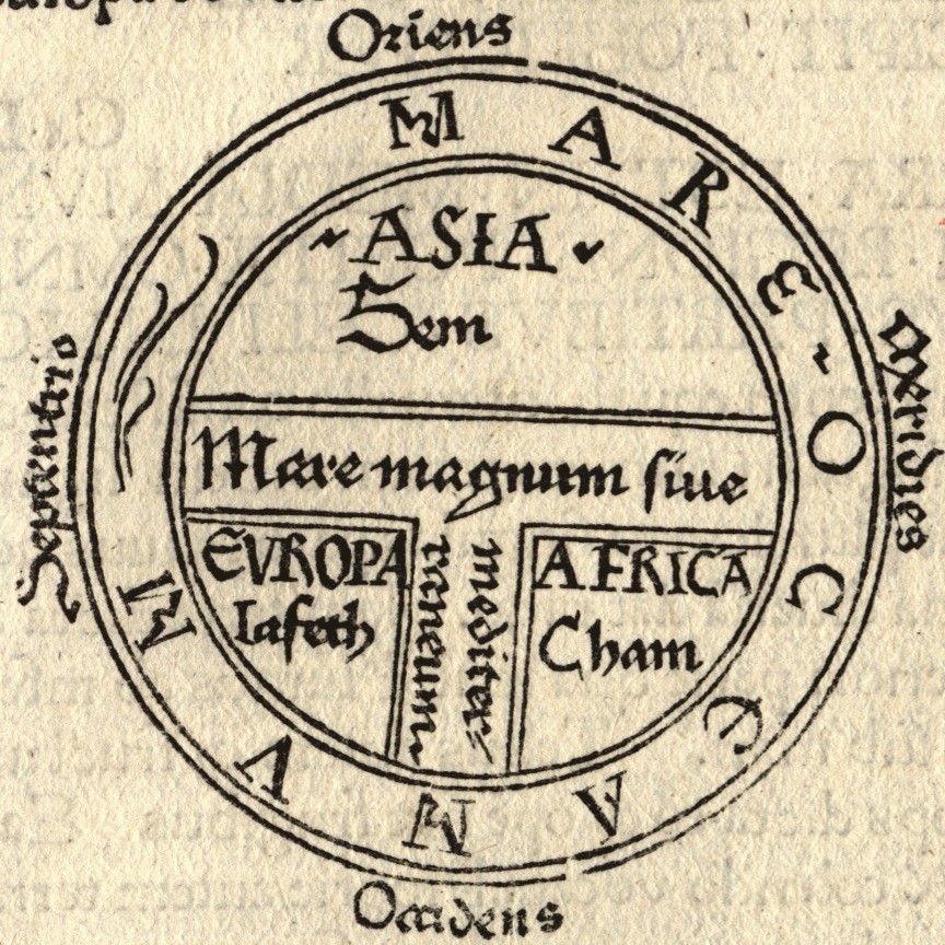
A T and O map or O–T or T–O map (''orbis terrarum'', orb or circle of the lands; with the letter T inside an O), also known as an Isidoran map, is a type of early world map that represents the Afro-Eurasian landmass as a circle (= O) divided into three parts by a T-shaped combination of the Mediterranean sea, the river Tanais (Don) and the Nile. The origins of this diagram are contested, with some scholars hypothesizing an origin in Roman or late antiquity, while others consider it to have originated in 7th or early-8th century Spain. The earliest surviving example of a T-O map is found in a late-7th or early-8th century copy of Isidore of Seville's (c. 560–636) ''De natura rerum'', which alongside his ''Etymologiae'' (c. 625) are two of the most common texts to be accompanied by such a diagram in the Middle Ages. A later manuscript added the names of Noah's sons ( Sem, Iafeth and Cham) for each of the three continents (see Biblical terminology for race).: "...the ... [...More Info...] [...Related Items...] OR: [Wikipedia] [Google] [Baidu] |
Neocolonialism (video Game)
''Neocolonialism'' is a strategic computer game in which players take over different regions all over the world. It is turn-based, and allows three to six players at once. It is produced by American indie studio Subaltern Games, and designed by Esther Alter. As in ''Risk'', the world is divided into a number of different regions that players try to dominate. Unlike ''Risk'', however, the goal is not to occupy as many regions as possible, but to liquidate the votes players have purchased in regions in order to put as much money as possible in a Swiss Bank account. The game lasts for twelve turns. At the end of the twelfth turn, the player who has the most money in their bank account is the winner. Also, ''Neocolonialism'' differs from ''Risk'' in that the map of the world is rotated 180° in relation to the most common world map orientation, putting the north at the bottom. In the introductory tutorial, the player is told, "You will learn the basics of how to ruin the world." Lat ... [...More Info...] [...Related Items...] OR: [Wikipedia] [Google] [Baidu] |
The New Yorker
''The New Yorker'' is an American magazine featuring journalism, commentary, criticism, essays, fiction, satire, cartoons, and poetry. It was founded on February 21, 1925, by Harold Ross and his wife Jane Grant, a reporter for ''The New York Times''. Together with entrepreneur Raoul H. Fleischmann, they established the F-R Publishing Company and set up the magazine's first office in Manhattan. Ross remained the editor until his death in 1951, shaping the magazine's editorial tone and standards. ''The New Yorker''s fact-checking operation is widely recognized among journalists as one of its strengths. Although its reviews and events listings often focused on the Culture of New York City, cultural life of New York City, ''The New Yorker'' gained a reputation for publishing serious essays, long-form journalism, well-regarded fiction, and humor for a national and international audience, including work by writers such as Truman Capote, Vladimir Nabokov, and Alice Munro. In the late ... [...More Info...] [...Related Items...] OR: [Wikipedia] [Google] [Baidu] |
Leo Cullum
Leo Aloysius Cullum (January 11, 1942 – October 23, 2010) was an American cartoonist, one of the more frequent contributors to ''The New Yorker'' with more than 800 gag cartoons published. He started his drawing career after having served as a pilot in the United States Marine Corps during the Vietnam War and flying planes commercially for Trans World Airlines and American Airlines. Born in Newark, New Jersey, Cullum was raised in North Bergen, New Jersey and earned his undergraduate degree in 1963 from the College of the Holy Cross, where he majored in English. He joined the United States Marine Corps after graduating from college, earning a commission as a second Lieutenant. Upon completion of his flight training in Pensacola, Florida, Cullum deployed to Vietnam, where he flew more than 200 missions, mostly ground attacks in support of the infantry in addition to attacks on the Viet Cong supply lines on the Ho Chi Minh trail in Laos. Though the missions over Laos were not offic ... [...More Info...] [...Related Items...] OR: [Wikipedia] [Google] [Baidu] |
Quino
Joaquín Salvador Lavado Tejón (17 July 193230 September 2020), better known by his pen name Quino (), was an Argentina, Argentine cartoonist. His comic strip ''Mafalda'' (which ran from 1964 to 1973) is popular in many parts of the Americas and Europe and has been praised for its use of social satire as a commentary on real-life issues. Early life Joaquín Salvador Lavado Tejón was born in Mendoza, Argentina, Mendoza, Argentina, on 17 July 1932 to emigrant Andalusians, Andalusian parents from Fuengirola, Province of Málaga, Málaga. Following Spanish name tradition, "Lavado" is his first or paternal surname, and "Tejón" his maternal one. Because of his parents' limited social circle, he spoke with an Andalusian accent until the age of six. He retained an affection for his parents' Spanish culture and flamenco into his later years. He obtained Spanish citizenship in 1990 and remained a dual citizen of Spain and Argentina. He was called "Quino" from his childhood on, to dis ... [...More Info...] [...Related Items...] OR: [Wikipedia] [Google] [Baidu] |


