|
Solar Eclipse Of January 25, 1944
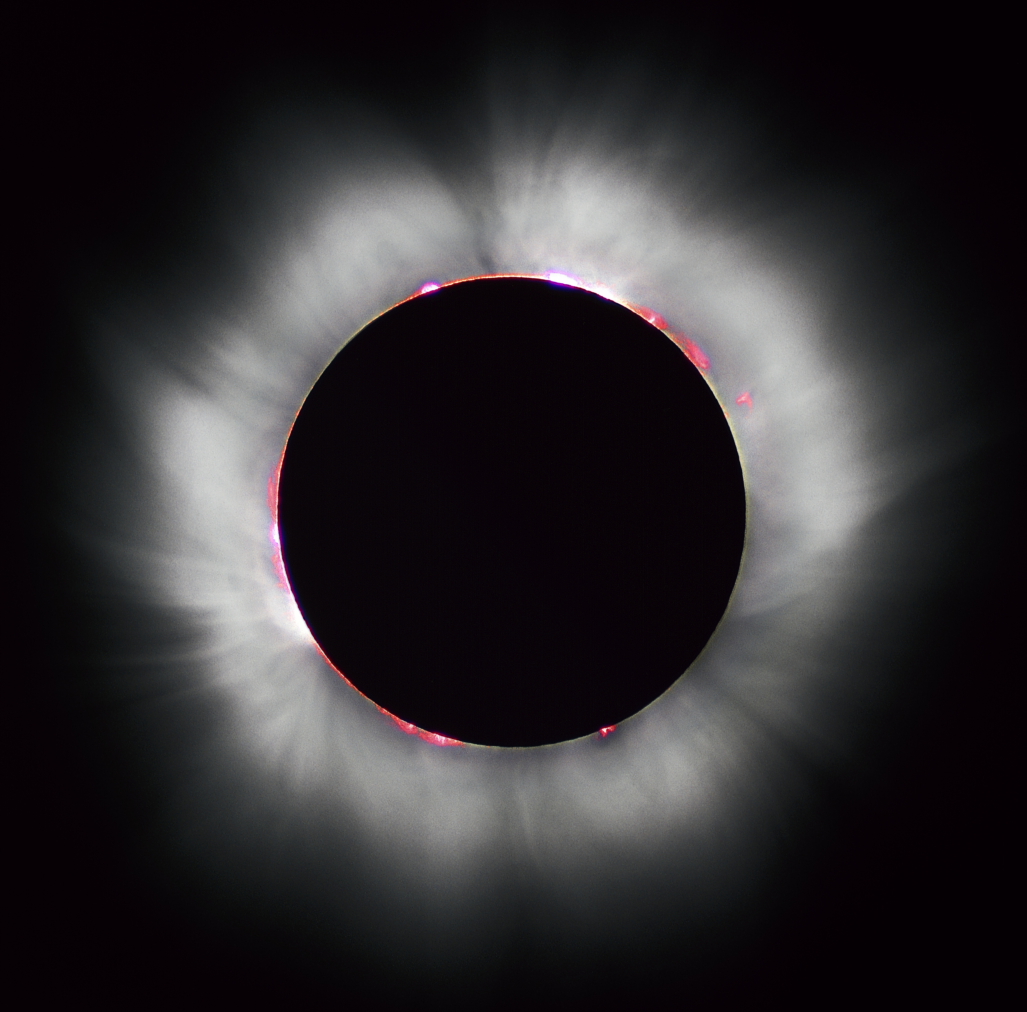
A total solar eclipse occurred at the Moon's descending node of orbit on Tuesday, January 25, 1944, with a magnitude of 1.0428. A solar eclipse occurs when the Moon passes between Earth and the Sun, thereby totally or partly obscuring the image of the Sun for a viewer on Earth. A total solar eclipse occurs when the Moon's apparent diameter is larger than the Sun's, blocking all direct sunlight, turning day into darkness. Totality occurs in a narrow path across Earth's surface, with the partial solar eclipse visible over a surrounding region thousands of kilometres wide. Occurring about 20 hours before perigee (on January 26, 1944, at 11:30 UTC), the Moon's apparent diameter was larger. Totality was visible from Peru, Brazil, British Sierra Leone (today's Sierra Leone), and French West Africa (the parts now belonging to Guinea, Mali, Burkina Faso and Niger, including Guinean capital Conakry). A partial eclipse was visible for parts of southern North America, Central America, the Ca ... [...More Info...] [...Related Items...] OR: [Wikipedia] [Google] [Baidu] |
Solar Eclipse
A solar eclipse occurs when the Moon passes between Earth and the Sun, thereby obscuring the view of the Sun from a small part of Earth, totally or partially. Such an alignment occurs approximately every six months, during the eclipse season in its new moon phase, when the Moon's orbital plane is closest to Ecliptic, the plane of Earth's orbit. In a total eclipse, the disk of the Sun is fully obscured by the Moon. In #Types, partial and annular eclipses, only part of the Sun is obscured. Unlike a lunar eclipse, which may be viewed from anywhere on the night side of Earth, a solar eclipse can only be viewed from a relatively small area of the world. As such, although total solar eclipses occur somewhere on Earth every 18 months on average, they recur at any given place only once every 360 to 410 years. If the Moon were in a perfectly circular orbit and in the same orbital plane as Earth, there would be total solar eclipses once a month, at every new moon. Instead, because the Mo ... [...More Info...] [...Related Items...] OR: [Wikipedia] [Google] [Baidu] |
North America
North America is a continent in the Northern Hemisphere, Northern and Western Hemisphere, Western hemispheres. North America is bordered to the north by the Arctic Ocean, to the east by the Atlantic Ocean, to the southeast by South America and the Caribbean Sea, and to the south and west by the Pacific Ocean. The region includes Middle America (Americas), Middle America (comprising the Caribbean, Central America, and Mexico) and Northern America. North America covers an area of about , representing approximately 16.5% of Earth's land area and 4.8% of its total surface area. It is the third-largest continent by size after Asia and Africa, and the list of continents and continental subregions by population, fourth-largest continent by population after Asia, Africa, and Europe. , North America's population was estimated as over 592 million people in list of sovereign states and dependent territories in North America, 23 independent states, or about 7.5% of the world's popula ... [...More Info...] [...Related Items...] OR: [Wikipedia] [Google] [Baidu] |
Popular Astronomy (US Magazine)
''Popular Astronomy'' is an American magazine published by John August Media, LLC and hosted at TechnicaCuriosa.com for amateur astronomers. Prior to its revival in 2009, the title was published between 1893 and 1951. It was the successor to '' The Sidereal Messenger'', which was published from March 1882 to 1892. The first issue of ''Popular Astronomy'' appeared in September 1893. Each yearly volume of ''Popular Astronomy'' contained 10 issues, for a total of 59 volumes. The first editor, from 1893 to 1909, was William W. Payne of Carleton College, with Charlotte R. Willard as co-editor 1893–1905. Payne was followed by Herbert C. Wilson, who served in the post between 1909 and 1926. Dr. Curvin Henry Gingrich, Professor of Mathematics and Astronomy at Carleton, served as the final editor for the initial publication run, which ended with his sudden death (by heart attack) in 1951. Dr. Gingrich received a six-page eulogy written by Dr. Frederick C. Leonard, in the August 1951 ... [...More Info...] [...Related Items...] OR: [Wikipedia] [Google] [Baidu] |
Stellar Corona
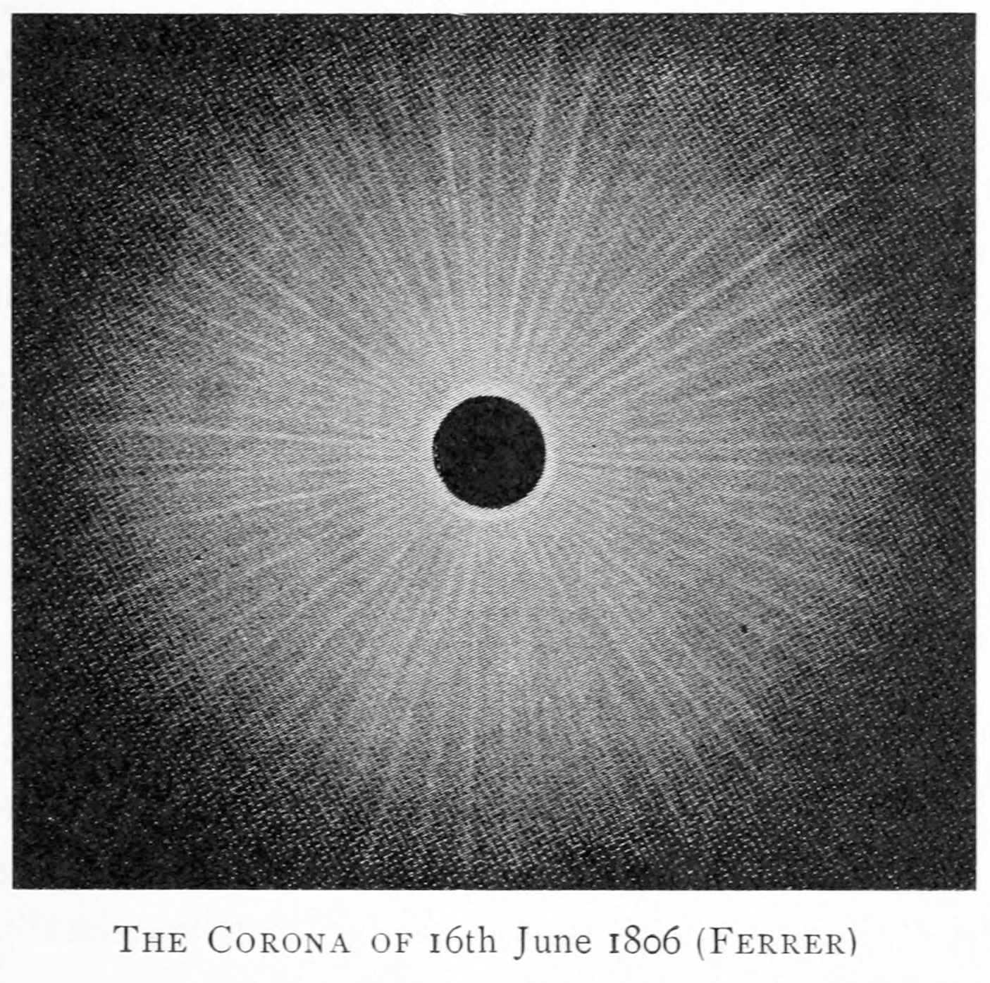
In astronomy, a corona (: coronas or coronae) is the outermost layer of a star's Stellar atmosphere, atmosphere. It is a hot but relatively luminosity, dim region of Plasma (physics), plasma populated by intermittent coronal structures such as solar prominence, prominences, coronal loops, and helmet streamers. The Sun's corona lies above the chromosphere and extends millions of kilometres into outer space. Coronal light is typically obscured by diffuse sky radiation and Glare (vision), glare from the solar disk, but can be easily seen by the naked eye during a total solar eclipse or with a specialized coronagraph. Spectroscopic measurements indicate strong ionization in the corona and a plasma temperature in excess of , much hotter than the surface of the Sun, known as the photosphere. is, in turn, derived . History In 1724, French-Italian astronomer Giacomo F. Maraldi recognized that the aura visible during a solar eclipse belongs to the Sun, not to the Moon. In 1809, Span ... [...More Info...] [...Related Items...] OR: [Wikipedia] [Google] [Baidu] |
Solar Zenith Angle
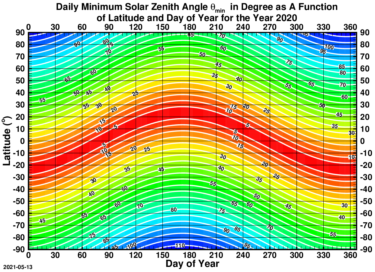
The solar zenith angle is the zenith angle of the sun, i.e., the angle between the sun’s rays and the vertical direction. It is the complement to the solar altitude or solar elevation, which is the altitude angle or elevation angle between the sun’s rays and a horizontal plane. At solar noon, the altitude angle (complement of the solar angle) is at a minimum and is equal to latitude minus solar declination angle. This is the basis by which ancient mariners navigated the oceans. Solar zenith angle is normally used in combination with the solar azimuth angle to determine the position of the Sun as observed from a given location on the surface of the Earth. Formula \cos \theta_s = \sin \alpha_s = \sin \Phi \sin \delta + \cos \Phi \cos \delta \cos h where * \theta_s is the ''solar zenith angle'' * \alpha_s is the ''solar altitude angle'', \alpha_s = 90^\circ - \theta_s * h is the hour angle, in the local solar time. * \delta is the current declination of the Sun * \Phi is the ... [...More Info...] [...Related Items...] OR: [Wikipedia] [Google] [Baidu] |
Chiclayo
Chiclayo (; mochica language, Mochica: ''Cɥiclaiæp'') is the principal city and capital of the Lambayeque region and Chiclayo Province in northern Peru. It is located from the Pacific coast, from the city of Trujillo, Peru, Trujillo, and from the country's capital, Lima. The city was originally founded by Spanish priests as "Santa María de los Valles de Chiclayo" in the 16th century, acting as a small town of passage and rest of travelers. It was declared an official city on 15 April 1835 by president Felipe Santiago Salaverry. He named Chiclayo "the Heroic City" to recognize the courage of its citizens in the fight for independence, a title it still holds. Other nicknames for Chiclayo include "The Capital of Friendship" and the "Pearl of the North", due to its kind and friendly nature of its people. Chiclayo is Peru's List of 20 largest cities in Peru, fourth-largest city, after Lima, Arequipa, and Trujillo, with a population of 738,000 as of 2011. [...More Info...] [...Related Items...] OR: [Wikipedia] [Google] [Baidu] |
Mexico
Mexico, officially the United Mexican States, is a country in North America. It is the northernmost country in Latin America, and borders the United States to the north, and Guatemala and Belize to the southeast; while having maritime boundary, maritime boundaries with the Pacific Ocean to the west, the Caribbean Sea to the southeast, and the Gulf of Mexico to the east. Mexico covers 1,972,550 km2 (761,610 sq mi), and is the List of countries by area, thirteenth-largest country in the world by land area. With a population exceeding 130 million, Mexico is the List of countries by population, tenth-most populous country in the world and is home to the Hispanophone#Countries, largest number of native Spanish speakers. Mexico City is the capital and List of cities in Mexico, largest city, which ranks among the List of cities by population, most populous metropolitan areas in the world. Human presence in Mexico dates back to at least 8,000 BC. Mesoamerica, considered a cradle ... [...More Info...] [...Related Items...] OR: [Wikipedia] [Google] [Baidu] |
Tacubaya
Tacubaya is a Poverty in Mexico, working-class area of Mexico City in the borough of Miguel Hidalgo, D.F., Miguel Hidalgo. The ''colonia (Mexico), colonia'' Tacubaya and adjacent areas in other colonias are collectively referred to as Tacubaya. San Miguel Chapultepec sección II, Observatorio, Daniel Garza, and Ampliación Daniel Garza are also considered part of Tacubaya. The area has been inhabited since the fifth century BC. Its name comes from Nahuatl, meaning “where water is gathered.” From the Spanish colonization of the Americas , colonial period to the beginning of the 20th century, Tacubaya was an separate entity to historic center of Mexico City, Mexico City and many of the city’s wealthy residents, including viceroys, built residences there to enjoy the area’s scenery. From the mid-19th century on, Tacubaya began to urbanization, urbanize both due to the growth of Mexico City and the growth of its own population. Along with this urbanization, the are ... [...More Info...] [...Related Items...] OR: [Wikipedia] [Google] [Baidu] |
National Astronomical Observatory (Mexico)
The National Astronomical Observatory (Spanish: ''Observatorio Astronómico Nacional''—OAN) is an astronomical observatory in Baja California, Mexico. History Mexico City The observatory was first established on the balcony of Chapultepec Castle in Mexico City in 1878. The observatory has been operated by the National Autonomous University of Mexico (UNAM) since 1929. It was later moved to Palacio del Ex-Arzobispado in Tacubaya, then on the outskirts of the city on the west side of the Federal District. The location is remembered by the name Metro Observatorio, the terminal station of the Line 1 of the Mexico City Metro located nearby. Puebla In the middle of the 20th century, OAN had to move from the increasingly crowded and polluted Valley of Mexico, to Tonantzintla in Puebla state, Central Mexico. Baja California In 1967 excessive air pollution and night light pollution caused another move, from Puebla to atop the Sierra San Pedro Mártir mountain range of Baja Cali ... [...More Info...] [...Related Items...] OR: [Wikipedia] [Google] [Baidu] |
Central Africa
Central Africa (French language, French: ''Afrique centrale''; Spanish language, Spanish: ''África central''; Portuguese language, Portuguese: ''África Central'') is a subregion of the African continent comprising various countries according to different definitions. Middle Africa is an analogous term used by the United Nations in its United Nations geoscheme for Africa, geoscheme for Africa and consists of the following countries: Angola, Cameroon, Central African Republic, Chad, Democratic Republic of the Congo, Republic of the Congo, Equatorial Guinea, Gabon, and São Tomé and Príncipe. The United Nations Office for Central Africa also includes Burundi and Rwanda in the region, which are considered part of East Africa in the geoscheme. These eleven countries are members of the Economic Community of Central African States (ECCAS). Six of those countries (Cameroon, Central African Republic, Chad, Equatorial Guinea, Gabon, and Republic of the Congo) are also members of the ... [...More Info...] [...Related Items...] OR: [Wikipedia] [Google] [Baidu] |
West Africa
West Africa, also known as Western Africa, is the westernmost region of Africa. The United Nations geoscheme for Africa#Western Africa, United Nations defines Western Africa as the 16 countries of Benin, Burkina Faso, Cape Verde, The Gambia, Ghana, Guinea, Guinea-Bissau, Ivory Coast, Liberia, Mali, Mauritania, Niger, Nigeria, Senegal, Sierra Leone, and Togo, as well as Saint Helena, Ascension and Tristan da Cunha (United Kingdom Overseas Territories, United Kingdom Overseas Territory).Paul R. Masson, Catherine Anne Pattillo, "Monetary union in West Africa (ECOWAS): is it desirable and how could it be achieved?" (Introduction). International Monetary Fund, 2001. The population of West Africa is estimated at around million people as of , and at 381,981,000 as of 2017, of which 189,672,000 were female and 192,309,000 male.United Nations Department of Economic and Social Affairs, Population Division (2017). World Population Prospects: The 2017 Revision, custom data acquired via webs ... [...More Info...] [...Related Items...] OR: [Wikipedia] [Google] [Baidu] |
Western Europe
Western Europe is the western region of Europe. The region's extent varies depending on context. The concept of "the West" appeared in Europe in juxtaposition to "the East" and originally applied to the Western half of the ancient Mediterranean world, the Latin West of the Roman Empire, and "Western Christendom". Beginning with the Renaissance and the Age of Discovery, roughly from the 15th century, the concept of ''Europe'' as "the Western world, West" slowly became distinguished from and eventually replaced the dominant use of "Christendom" as the preferred endonym within the area. By the Age of Enlightenment and the Industrial Revolution, the concepts of "Eastern Europe" and "Western Europe" were more regularly used. The distinctiveness of Western Europe became most apparent during the Cold War, when Europe was divided for 40 years by the Iron Curtain into the Western Bloc and Eastern Bloc, each characterised by distinct political and economical systems. Historical divisions ... [...More Info...] [...Related Items...] OR: [Wikipedia] [Google] [Baidu] |


