|
Chiclayo
Chiclayo (; mochica language, Mochica: ''Cɥiclaiæp'') is the principal city and capital of the Lambayeque region and Chiclayo Province in northern Peru. It is located from the Pacific coast, from the city of Trujillo, Peru, Trujillo, and from the country's capital, Lima. The city was originally founded by Spanish priests as "Santa María de los Valles de Chiclayo" in the 16th century, acting as a small town of passage and rest of travelers. It was declared an official city on 15 April 1835 by president Felipe Santiago Salaverry. He named Chiclayo "the Heroic City" to recognize the courage of its citizens in the fight for independence, a title it still holds. Other nicknames for Chiclayo include "The Capital of Friendship" and the "Pearl of the North", due to its kind and friendly nature of its people. Chiclayo is Peru's List of 20 largest cities in Peru, fourth-largest city, after Lima, Arequipa, and Trujillo, with a population of 738,000 as of 2011. [...More Info...] [...Related Items...] OR: [Wikipedia] [Google] [Baidu] |
Chiclayo Metropolitan Area
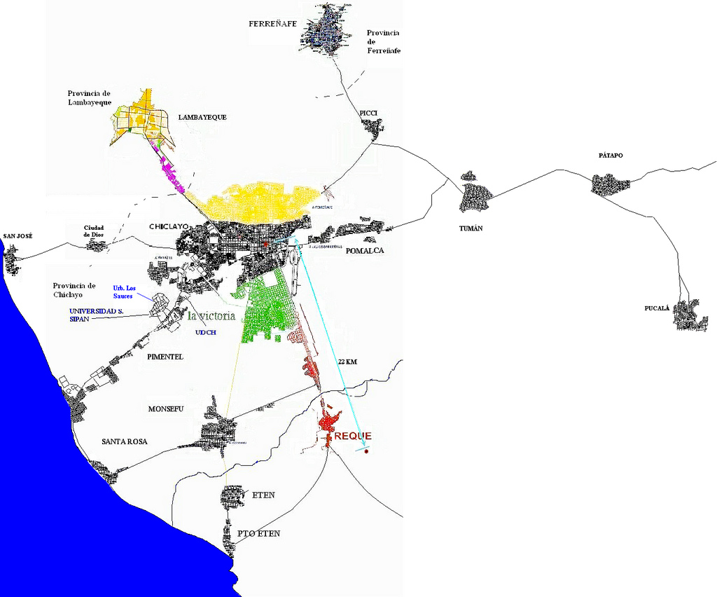
The Chiclayo Metropolitan Area is the name used to refer to the metropolitan area whose principal city is Chiclayo, according to Municipality of Chiclayo. According to population statistics of INEI It is List of metropolitan areas of Peru, the fourth most populous metropolitan area of Peru in year 2015. Population According to studies of municipality of Chiclayo the population of Chiclayo metropolitan in the year 2017 was of 697.871 people distributed in its metropolitan districts. Graphics of evolution of the population In the following Graphics the evolution of the population of Chiclayo metropolitan area. See also * Chiclayo Province * List of metropolitan areas of Peru * Peru References {{coord missing, Peru Metropolitan areas of Peru Chiclayo ... [...More Info...] [...Related Items...] OR: [Wikipedia] [Google] [Baidu] |
Chiclayo District
Chiclayo District is one of twenty districts of the Chiclayo province in Peru. Instituto Nacional de Estadística e Informática. Banco de Información Distrital''. Retrieved April 11, 2008. The district is home to the principal city of Chiclayo. References See also * Administrative divisions of Peru The administrative divisions of Peru have changed from time to time since the nation gained independence from Spain in the early 19th century. The old territorial subdivisions have split or merged due to several reasons, the most common ones being ... Districts of the Chiclayo province Districts of the Department of Lambayeque {{Lambayeque-geo-stub ... [...More Info...] [...Related Items...] OR: [Wikipedia] [Google] [Baidu] |
Metropolitan Areas Of Peru
The following is a list of the most populous Peruvian metropolitan areas with over 300,000 inhabitants. Note that the populations of metropolitan areas are not city populations but rather a combination of a main large city and many other smaller satellite cities. In Peru, cities with a population of more than 500,000 and with a metropolitan development plan are considered metropolises. As of the 2007 census, these cities are Lima, Arequipa, and Trujillo. Composition :* Lima metropolitan area Lima metropolitan area is composed of 5 sub regions that group 43 urban districts of Lima Province and 6 districts of Callao Province. These sub regions are the Lima Norte, Lima Sur, Lima Este, Central Lima, and Callao with a total estimated population in 2015 of 9.886.647 people. :*Arequipa Metropolitan Area :*Trujillo Metropolitan Area :*Chiclayo Metropolitan Area :*Piura: Piura, Castilla, Catacaos. :*Iquitos: Iquitos, Punchana, San Juan Bautista, Belén. :*Cus ... [...More Info...] [...Related Items...] OR: [Wikipedia] [Google] [Baidu] |
Peru
Peru, officially the Republic of Peru, is a country in western South America. It is bordered in the north by Ecuador and Colombia, in the east by Brazil, in the southeast by Bolivia, in the south by Chile, and in the south and west by the Pacific Ocean. Peru is a Megadiverse countries, megadiverse country, with habitats ranging from the arid plains of the Pacific coastal region in the west, to the peaks of the Andes mountains extending from the north to the southeast of the country, to the tropical Amazon basin rainforest in the east with the Amazon River. Peru has Demographics of Peru, a population of over 32 million, and its capital and largest city is Lima. At , Peru is the List of countries and dependencies by area, 19th largest country in the world, and the List of South American countries by area, third largest in South America. Pre-Columbian Peru, Peruvian territory was home to Andean civilizations, several cultures during the ancient and medieval periods, and has one o ... [...More Info...] [...Related Items...] OR: [Wikipedia] [Google] [Baidu] |
Provinces Of Peru
The provinces of Peru () are the second-level administrative subdivisions of the country. They are divided into districts (). There are 196 provinces in Peru, grouped into 25 regions, except for Lima Province which does not belong to any region. This makes an average of seven provinces per region. The region with the fewest provinces is Callao (one) and the region with the most is Ancash (twenty). While provinces in the sparsely populated Amazon rainforest of eastern Peru tend to be larger, there is a large concentration of them in the north-central area of the country. The province with the fewest districts is Purús Province, with just one district. The province with the most districts is Lima Province, with 43 districts. The most common number of districts per province is eight; a total of 29 provinces share this number of districts. Provinces table The table below shows all provinces with their capitals and the region in which they are located. The UBIGEO code unique ... [...More Info...] [...Related Items...] OR: [Wikipedia] [Google] [Baidu] |
Lambayeque Region
Lambayeque () is a Administrative divisions of Peru, department and Regional Government of Lambayeque, region in northwestern Peru known for its rich Moche culture, Moche and Chimú culture, Chimú historical past. The region's name originates from the ancient pre-Inca Empire, Inca civilization of the ''Sican culture, Lambayeque (''muchic: ''Ñampaxllæc)'' . It is the second-smallest department in Peru after Department of Tumbes, Tumbes, but it is also its most densely populated department and its eighth most populous department. Etymology The name ''Lambayeque'' is a Spanish derivation of the Muchik language, muchik word for god ''Yampellec'', said to have been worshipped by the first Lambayeque culture, Lambayeque king, ''Naymlap''. The Spanish gave the name to the early people. Geography The vast plains that make up the department of Lambayeque's territory are watered by rivers that originate in the Andes; cultivation is only possible in a small portion of this parched ... [...More Info...] [...Related Items...] OR: [Wikipedia] [Google] [Baidu] |
Districts Of Peru
The districts of Peru () are the third-level country subdivisions of Peru. They are subdivisions of the provinces of Peru, provinces, which in turn are subdivisions of the larger regions of Peru, regions or departments. There are 1,838 districts in total. Overview A 1982 law requires a minimum of residents in an area for a new district to be legally established: 3,500 if it is located in the rainforest, 4,000 in the Andes highlands and 10,000 in the Chala, coastal area. In the dry Andean area, many districts have less than 3,500 inhabitants due to low population density in the area. In some cases, their populations have decreased in comparison to the days when they were founded. Districts that are located at very high altitudes tend to be scarcely populated. These districts usually are large in area, have few available land for use. Many basic government services do not reach all residents of these districts due to their difficult geography. Many lack financial means to govern th ... [...More Info...] [...Related Items...] OR: [Wikipedia] [Google] [Baidu] |
Zaña
Zaña or Saña (''Çañap'' in mochica language, Mochica) is the capital of Zaña District in the Chiclayo Province of Lambayeque region in northern Peru. It is located inland from the Pacific Ocean at an elevation of in the valley of the Zaña River. Zaña had a population of 4,510 in 2017. The town was founded in 1563 by the Spanish conquerors of Peru. The Zaña Valley became a major area of sugar cane production and Zaña was one of the most important cities of colonial Peru. The wealth of Zaña attracted English pirates who raided the city in 1686. A flood destroyed Zaña in 1720 and it never recovered its previous importance. Ruins from the flood still exist at the edge of the 21st century town. Imported African slaves made up a major part of the population of the city and its environs during its heyday. The Afro-Peruvian Museum is in Zaña and in 2017 the museum was declared by UNESCO to be a Site of Remembrance of Slavery and African Cultural Heritage. History The ... [...More Info...] [...Related Items...] OR: [Wikipedia] [Google] [Baidu] |
Wari Empire
The Wari Empire or Huari Empire was a political formation that emerged around 600 in Peru's Ayacucho Basin and grew to cover much of coastal and highland Peru. The empire lasted for about 500 years, until 1100.Wade, Lizzie (17 August 2016), "The Wari's grisly end—the fall of a South American empire", ''Science'', retrieved 28 April 2024. It existed during the same era as the Tiwanaku culture, and at one time, was thought to have been derived from it. In 2008, archeologists found a precolumbian city, the Northern Wari ruins (also called Cerro Pátapo) near modern Chiclayo. The find was the first extensive settlement related to the Wari culture discovered that far north. Archaeological discoveries have continued over the past decade. In 2023, archaeologists discovered a 1200-year-old Wari ritual complex in Arequipa. While more discoveries are being made regarding the Wari Empire, archaeologists are able to draw more conclusions about the Wari Empire's culture. Political rel ... [...More Info...] [...Related Items...] OR: [Wikipedia] [Google] [Baidu] |
Mochica Language
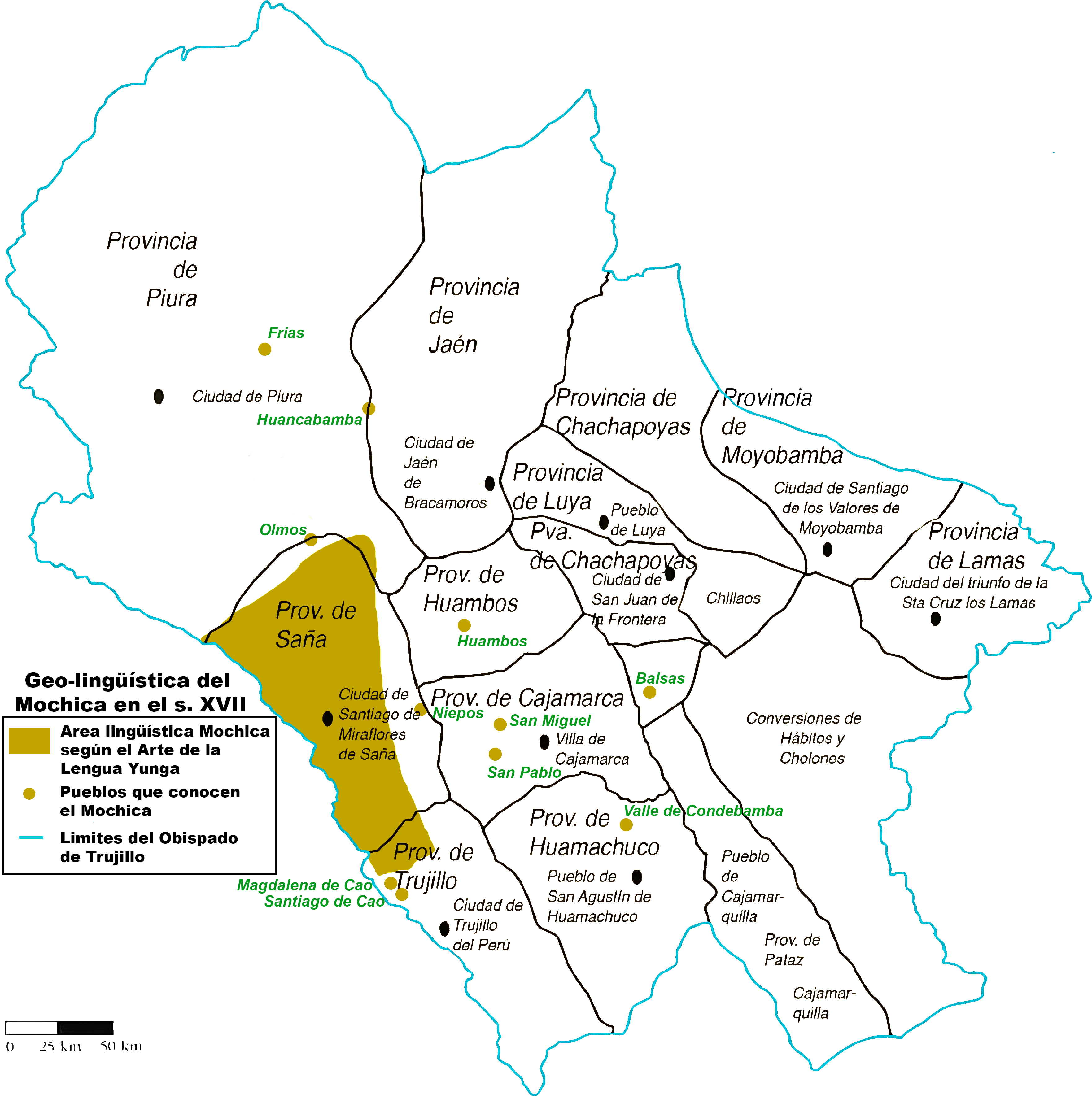
Mochica is an extinct language formerly spoken along the northwest coast of Peru and in an inland village. First documented in 1607, the language was widely spoken in the area during the 17th century and the early 18th century. By the late 19th century, the language was dying out and spoken only by a few people in the village of Etén, in Chiclayo. It died out as a spoken language around 1920, but certain words and phrases continued to be used until the 1960s. A revival movement has appeared in recent times. Classification Mochica is usually considered to be a language isolate, but has also been hypothesized as belonging to a wider Chimuan language family. Stark (1972) proposes a connection with Uru–Chipaya as part of a Maya–Yunga–Chipayan macrofamily hypothesis. Denominations The ''yunga'' form is mentioned in the work of Fernando de la Carrera, "''yunca''" is another form mentioned by varieties of Quechua, "''muchic''" is only mentioned by the Augustinian father ... [...More Info...] [...Related Items...] OR: [Wikipedia] [Google] [Baidu] |
List Of 20 Largest Cities In Peru
This is a list of cities in Peru by population. For metropolitan areas see List of metropolitan areas of Peru. List See also *List of metropolitan areas of Peru *List of regions by population of Peru References External links {{Peru lists Cities in Peru, Populated places in Peru, * Peru geography-related lists, Cities, largest Lists of cities by population, Peru Lists of cities by country, Peru, List of cities in Lists of cities in the Americas, Peru ... [...More Info...] [...Related Items...] OR: [Wikipedia] [Google] [Baidu] |


