|
Solar Eclipse Of June 8, 1918
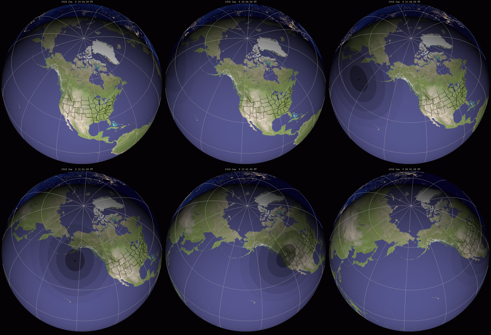
A total solar eclipse occurred at the Moon's Lunar node, descending node of orbit between Saturday, June 8 and Sunday, June 9, 1918, with a Magnitude of eclipse, magnitude of 1.0292. A solar eclipse occurs when the Moon passes between Earth and the Sun, thereby totally or partly obscuring the image of the Sun for a viewer on Earth. A total solar eclipse occurs when the Moon's apparent diameter is larger than the Sun's, blocking all direct sunlight, turning day into darkness. Totality occurs in a narrow path across Earth's surface, with the partial solar eclipse visible over a surrounding region thousands of kilometres wide. Occurring 3.7 days after Apsis, perigee (on June 5, 1918, at 8:40 UTC), the Moon's apparent diameter was larger. The eclipse was viewable across the entire contiguous United States, an event which would not occur again until the solar eclipse of August 21, 2017. The Path The path of totality started south of Empire of Japan, Japan, went across the Pacific Oc ... [...More Info...] [...Related Items...] OR: [Wikipedia] [Google] [Baidu] |
Solar Eclipse
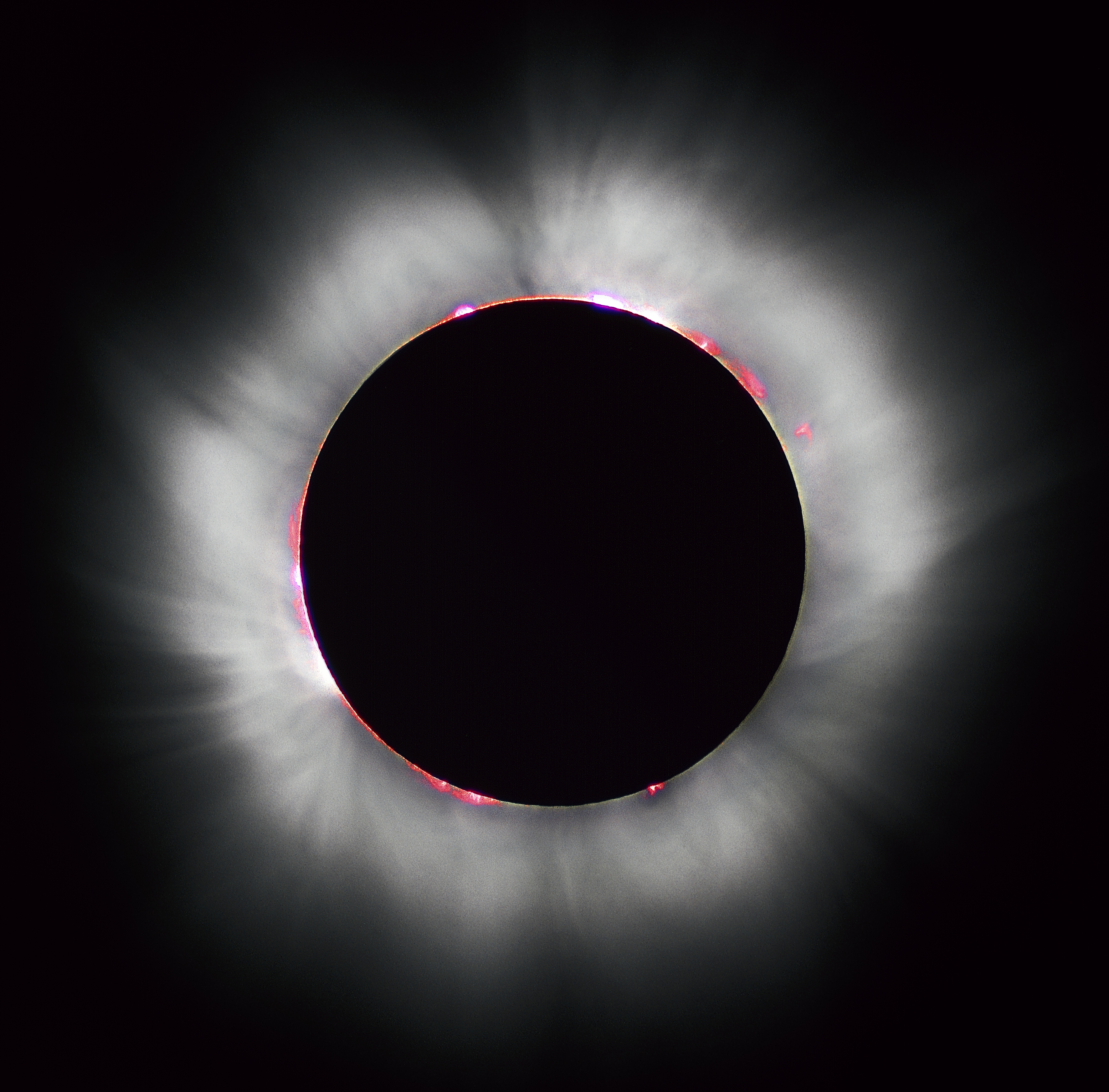
A solar eclipse occurs when the Moon passes between Earth and the Sun, thereby obscuring the view of the Sun from a small part of Earth, totally or partially. Such an alignment occurs approximately every six months, during the eclipse season in its new moon phase, when the Moon's orbital plane is closest to Ecliptic, the plane of Earth's orbit. In a total eclipse, the disk of the Sun is fully obscured by the Moon. In #Types, partial and annular eclipses, only part of the Sun is obscured. Unlike a lunar eclipse, which may be viewed from anywhere on the night side of Earth, a solar eclipse can only be viewed from a relatively small area of the world. As such, although total solar eclipses occur somewhere on Earth every 18 months on average, they recur at any given place only once every 360 to 410 years. If the Moon were in a perfectly circular orbit and in the same orbital plane as Earth, there would be total solar eclipses once a month, at every new moon. Instead, because the Mo ... [...More Info...] [...Related Items...] OR: [Wikipedia] [Google] [Baidu] |
East Asia
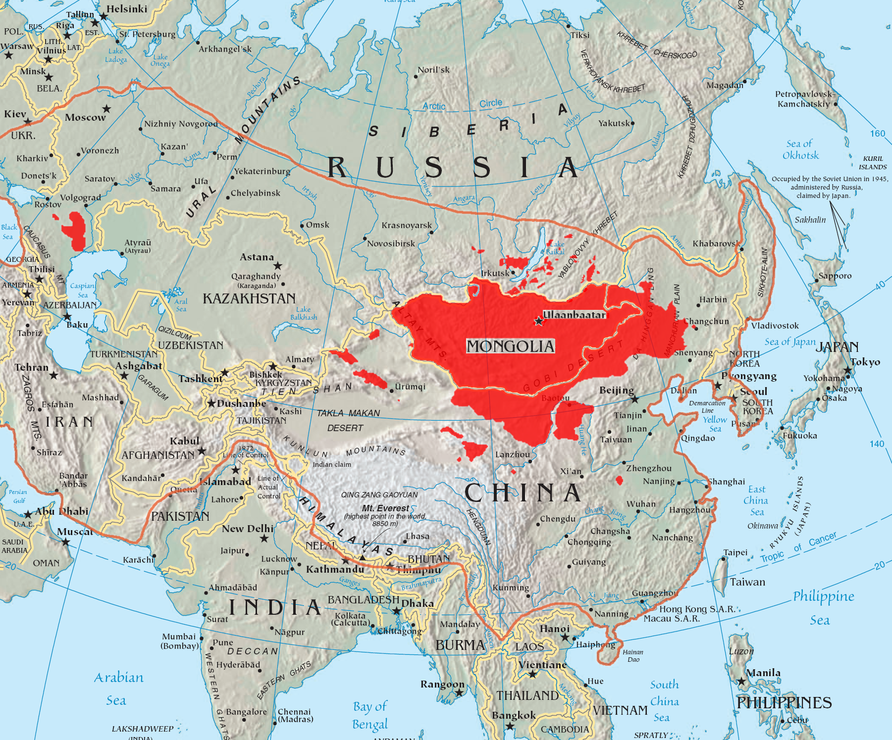
East Asia is a geocultural region of Asia. It includes China, Japan, Mongolia, North Korea, South Korea, and Taiwan, plus two special administrative regions of China, Hong Kong and Macau. The economies of Economy of China, China, Economy of Japan, Japan, Economy of South Korea, South Korea, and Economy of Taiwan, Taiwan are among the world's largest and most prosperous. East Asia borders North Asia to the north, Southeast Asia to the south, South Asia to the southwest, and Central Asia to the west. To its east is the Pacific Ocean. East Asia, especially History of China, Chinese civilization, is regarded as one of the earliest Cradle of civilization#China, cradles of civilization. Other ancient civilizations in East Asia that still exist as independent countries in the present day include the History of Japan, Japanese, History of Korea, Korean, and History of Mongolia, Mongolian civilizations. Various other civilizations existed as independent polities in East Asia in the past ... [...More Info...] [...Related Items...] OR: [Wikipedia] [Google] [Baidu] |
Oregon
Oregon ( , ) is a U.S. state, state in the Pacific Northwest region of the United States. It is a part of the Western U.S., with the Columbia River delineating much of Oregon's northern boundary with Washington (state), Washington, while the Snake River delineates much of its eastern boundary with Idaho. The 42nd parallel north, 42° north parallel delineates the southern boundary with California and Nevada. The western boundary is formed by the Pacific Ocean. Oregon has been home to many Indigenous peoples of the Americas, indigenous nations for thousands of years. The first European traders, explorers, and settlers began exploring what is now Oregon's Pacific coast in the early to mid-16th century. As early as 1564, the Spanish expeditions to the Pacific Northwest, Spanish began sending vessels northeast from the Philippines, riding the Kuroshio Current in a sweeping circular route across the northern part of the Pacific. In 1592, Juan de Fuca undertook detailed mapping a ... [...More Info...] [...Related Items...] OR: [Wikipedia] [Google] [Baidu] |
Baker City, Oregon
Baker City is a city in and the county seat of Baker County, Oregon, United States. It was named after Edward D. Baker, Edward Dickinson Baker, the only U.S. Senator ever killed in military combat. The population was 10,099 at the time of the 2020 United States census, 2020 census. History Platted in 1865, Baker City grew slowly in the beginning. A post office was established on March 27, 1866, but Baker City was not incorporated until 1874. Even so, it supplanted Auburn, Oregon, Auburn as the county seat in 1868. The city and county were named in honor of U.S. Senator Edward D. Baker, the only sitting senator to be killed in a military engagement. He died in 1861 while leading a failed charge of 1,700 Union Army soldiers up a ridge at Battle of Ball's Bluff, Ball's Bluff, Virginia, during the American Civil War. The Oregon Short Line Railroad came to Baker City in 1884, prompting growth; by 1900 it was the largest city between Salt Lake City and Portland and a trading center f ... [...More Info...] [...Related Items...] OR: [Wikipedia] [Google] [Baidu] |
Florida
Florida ( ; ) is a U.S. state, state in the Southeastern United States, Southeastern region of the United States. It borders the Gulf of Mexico to the west, Alabama to the northwest, Georgia (U.S. state), Georgia to the north, the Atlantic Ocean to the east, the Straits of Florida to the south, and The Bahamas to the southeast. About two-thirds of Florida occupies a peninsula between the Gulf of Mexico and the Atlantic Ocean. It has the List of U.S. states by coastline, longest coastline in the contiguous United States, spanning approximately , not including its many barrier islands. It is the only state that borders both the Gulf of Mexico and the Atlantic Ocean. With a population of over 23 million, it is the List of U.S. states and territories by population, third-most populous state in the United States and ranks List of states and territories of the United States by population density, seventh in population density as of 2020. Florida spans , ranking List of U.S. states ... [...More Info...] [...Related Items...] OR: [Wikipedia] [Google] [Baidu] |
Washington (state)
Washington, officially the State of Washington, is a U.S. state, state in the Pacific Northwest region of the United States. It is often referred to as Washington State to distinguish it from Washington, D.C., the national capital, both named after George Washington (the first President of the United States, U.S. president). Washington borders the Pacific Ocean to the west, Oregon to the south, Idaho to the east, and shares Canada–United States border, an international border with the Provinces and territories of Canada, Canadian province of British Columbia to the north. Olympia, Washington, Olympia is the List of capitals in the United States, state capital, and the most populous city is Seattle. Washington is the List of U.S. states and territories by area, 18th-largest state, with an area of , and the List of U.S. states and territories by population, 13th-most populous state, with a population of just less than 8 million. The majority of Washington's residents live ... [...More Info...] [...Related Items...] OR: [Wikipedia] [Google] [Baidu] |
South America
South America is a continent entirely in the Western Hemisphere and mostly in the Southern Hemisphere, with a considerably smaller portion in the Northern Hemisphere. It can also be described as the southern Subregion#Americas, subregion of the Americas. South America is bordered on the west by the Pacific Ocean, on the north and east by the Atlantic Ocean, and to the south by the Drake Passage; North America and the Caribbean Sea lie to the northwest. The continent includes twelve sovereign states: Argentina, Bolivia, Brazil, Chile, Colombia, Ecuador, Guyana, Paraguay, Peru, Suriname, Uruguay, and Venezuela; two dependent territory, dependent territories: the Falkland Islands and South Georgia and the South Sandwich Islands; and one administrative division, internal territory: French Guiana. The Dutch Caribbean ABC islands (Leeward Antilles), ABC islands (Aruba, Bonaire, and Curaçao) and Trinidad and Tobago are geologically located on the South-American continental shel ... [...More Info...] [...Related Items...] OR: [Wikipedia] [Google] [Baidu] |
Lesser Antilles
The Lesser Antilles is a group of islands in the Caribbean Sea, forming part of the West Indies in Caribbean, Caribbean region of the Americas. They are distinguished from the larger islands of the Greater Antilles to the west. They form an arc which begins east of Geography of Puerto Rico, Puerto Rico at the Virgin Islands, archipelago of the Virgin Islands, swings southeast through the Leeward Islands, Leeward and Windward Islands towards South America, and turns westward through the Leeward Antilles along the Geography of Venezuela, Venezuelan coast. Most of them are part of a long, partially volcanic arc, volcanic island arc between the Greater Antilles to the north-west and the continent of South America."West Indies." ''Merriam-Webster's Geographical Dictionary'', 3rd ed. 2001. () Springfield, MA: Merriam-Webster Inc., p. 1298. The islands of the Lesser Antilles form the eastern boundary of the Caribbean Sea where it meets the Atlantic Ocean. Together, the Lesser Antilles a ... [...More Info...] [...Related Items...] OR: [Wikipedia] [Google] [Baidu] |
North America
North America is a continent in the Northern Hemisphere, Northern and Western Hemisphere, Western hemispheres. North America is bordered to the north by the Arctic Ocean, to the east by the Atlantic Ocean, to the southeast by South America and the Caribbean Sea, and to the south and west by the Pacific Ocean. The region includes Middle America (Americas), Middle America (comprising the Caribbean, Central America, and Mexico) and Northern America. North America covers an area of about , representing approximately 16.5% of Earth's land area and 4.8% of its total surface area. It is the third-largest continent by size after Asia and Africa, and the list of continents and continental subregions by population, fourth-largest continent by population after Asia, Africa, and Europe. , North America's population was estimated as over 592 million people in list of sovereign states and dependent territories in North America, 23 independent states, or about 7.5% of the world's popula ... [...More Info...] [...Related Items...] OR: [Wikipedia] [Google] [Baidu] |
Russian Empire
The Russian Empire was an empire that spanned most of northern Eurasia from its establishment in November 1721 until the proclamation of the Russian Republic in September 1917. At its height in the late 19th century, it covered about , roughly one-sixth of the world's landmass, making it the list of largest empires, third-largest empire in history, behind only the British Empire, British and Mongol Empire, Mongol empires. It also Russian colonization of North America, colonized Alaska between 1799 and 1867. The empire's 1897 census, the only one it conducted, found a population of 125.6 million with considerable ethnic, linguistic, religious, and socioeconomic diversity. From the 10th to 17th centuries, the Russians had been ruled by a noble class known as the boyars, above whom was the tsar, an absolute monarch. The groundwork of the Russian Empire was laid by Ivan III (), who greatly expanded his domain, established a centralized Russian national state, and secured inde ... [...More Info...] [...Related Items...] OR: [Wikipedia] [Google] [Baidu] |


