|
Small Satellite Research Laboratory
The University of Georgia Small Satellite Research Laboratory (SSRL) is a research laboratory which builds CubeSat, CubeSats for Earth observation. The laboratory was conceived of in late 2015 and officially materialized in 2016 through a collaboration of faculty and students. Its original goal was to launch a student-built spacecraft into low Earth orbit, which it accomplished in 2020 with the Spectral Ocean Color imager (SPOC). Its current focuses are remote Earth observation (remote sensing) and space-based artificial intelligence. The lab is notable for its high number of undergraduate participants; as of the 2024 spring semester, over 300 students had been members of the lab for some period of time between 2016 and 2024. The SSRL has a Space Act Agreement with the NASA Ames Research Center. [...More Info...] [...Related Items...] OR: [Wikipedia] [Google] [Baidu] |
Wallops Flight Facility
Wallops Flight Facility (WFF) is a rocket launch site on Wallops Island on the Eastern Shore of Virginia, United States, just east of the Delmarva Peninsula and approximately north-northeast of Norfolk, VA, Norfolk. The facility is operated by the Goddard Space Flight Center in Greenbelt, Maryland, and primarily serves to support science and exploration missions for NASA and other Federal government of the United States, federal agencies. WFF includes an extensively instrumented range to support launches of more than a dozen types of sounding rockets; small expendable suborbital and orbital rockets; high-altitude balloon flights carrying scientific instruments for atmospheric and astronomical research; and, using its Research Airport, flight tests of aeronautical research aircraft, including unmanned aerial vehicles. There have been over 16,000 launches from the rocket testing range at Wallops since its founding in 1945 in the quest for information on the flight characteristi ... [...More Info...] [...Related Items...] OR: [Wikipedia] [Google] [Baidu] |
Digital Elevation Model
A digital elevation model (DEM) or digital surface model (DSM) is a 3D computer graphics representation of elevation data to represent terrain or overlaying objects, commonly of a planet, Natural satellite, moon, or asteroid. A "global DEM" refers to a discrete global grid. DEMs are used often in geographic information systems (GIS), and are the most common basis for digitally produced Relief mapping (computer graphics), relief maps. A digital terrain model (DTM) represents specifically the ground surface while DEM and DSM may represent tree top Canopy (biology), canopy or building roofs. While a DSM may be useful for Landscape planning, landscape modeling, Urban planning, city modeling and visualization applications, a DTM is often required for flood or drainage modeling, Land-use planning, land-use studies, geological applications, and other applications, and in planetary science. Terminology There is no universal usage of the terms ''digital elevation model'' (DEM), ''di ... [...More Info...] [...Related Items...] OR: [Wikipedia] [Google] [Baidu] |
Point Clouds
A point cloud is a discrete set of data points in space. The points may represent a 3D shape or object. Each point position has its set of Cartesian coordinates (X, Y, Z). Points may contain data other than position such as RGB colors, normals, timestamps and others. Point clouds are generally produced by 3D scanners or by photogrammetry software, which measure many points on the external surfaces of objects around them. As the output of 3D scanning processes, point clouds are used for many purposes, including to create 3D computer-aided design (CAD) or geographic information systems (GIS) models for manufactured parts, for metrology and quality inspection, and for a multitude of visualizing, animating, rendering, and mass customization applications. Alignment and registration When scanning a scene in real world using Lidar, the captured point clouds contain snippets of the scene, which requires alignment to generate a full map of the scanned environment. Point clouds are o ... [...More Info...] [...Related Items...] OR: [Wikipedia] [Google] [Baidu] |
Low Earth Orbit
A low Earth orbit (LEO) is an geocentric orbit, orbit around Earth with a orbital period, period of 128 minutes or less (making at least 11.25 orbits per day) and an orbital eccentricity, eccentricity less than 0.25. Most of the artificial objects in outer space are in LEO, peaking in number at an altitude around , while the farthest in LEO, before medium Earth orbit (MEO), have an altitude of 2,000 km, about one-third of the Earth radius, radius of Earth and near the beginning of the Van Allen radiation belt#Inner belt, inner Van Allen radiation belt. The term ''LEO region'' is used for the area of space below an altitude of (about one-third of Earth's radius). Objects in orbits that pass through this zone, even if they have an apogee further out or are sub-orbital spaceflight, sub-orbital, are carefully tracked since they present a collision risk to the many LEO satellites. No human spaceflights other than the lunar missions of the Apollo program (1968-1972) have gone beyond L ... [...More Info...] [...Related Items...] OR: [Wikipedia] [Google] [Baidu] |
Structure From Motion
Structure from motion (SfM) is a photogrammetric range imaging technique for estimating three-dimensional structures from two-dimensional image sequences that may be coupled with local motion signals. It is a classic problem studied in the fields of computer vision and visual perception. In computer vision, the problem of SfM is to design an algorithm to perform this task. In visual perception, the problem of SfM is to find an algorithm by which biological creatures perform this task. Principle Humans perceive a great deal of information about the three-dimensional structure in their environment by moving around it. When the observer moves, objects around them move different amounts depending on their distance from the observer. This is known as motion parallax, and this depth information can be used to generate an accurate 3D representation of the world around them. Finding structure from motion presents a similar problem to finding structure from stereo vision. In both ... [...More Info...] [...Related Items...] OR: [Wikipedia] [Google] [Baidu] |
Charge-coupled Device
A charge-coupled device (CCD) is an integrated circuit containing an array of linked, or coupled, capacitors. Under the control of an external circuit, each capacitor can transfer its electric charge to a neighboring capacitor. CCD sensors are a major technology used in digital imaging. Overview In a CCD image sensor, pixels are represented by Doping (semiconductor), p-doped metal–oxide–semiconductor (MOS) capacitors. These MOS capacitors, the basic building blocks of a CCD, are biased above the threshold for inversion when image acquisition begins, allowing the conversion of incoming photons into electron charges at the semiconductor-oxide interface; the CCD is then used to read out these charges. Although CCDs are not the only technology to allow for light detection, CCD image sensors are widely used in professional, medical, and scientific applications where high-quality image data are required. In applications with less exacting quality demands, such as consumer and pr ... [...More Info...] [...Related Items...] OR: [Wikipedia] [Google] [Baidu] |
Terra (satellite)
Terra (EOS AM-1) is a multi-national scientific research satellite operated by NASA in a Sun-synchronous orbit around the Earth. It takes simultaneous measurements of Earth's atmosphere, land, and water to understand how Earth is changing and to identify the consequences for life on Earth. It is the flagship of the Earth Observing System (EOS) and the first satellite of the system which was followed by Aqua (launched in 2002) and Aura (launched in 2004). Terra was launched in 1999. The name "Terra" comes from the Latin word for Earth. A naming contest was held by NASA among U.S. high school students. The winning essay was submitted by Sasha Jones of Brentwood, Missouri. The identifier "AM-1" refers to its orbit, passing over the equator in the morning. Launch The satellite was launched from Vandenberg Air Force Base on December 18th, 1999, aboard an Atlas IIAS vehicle and began collecting data on February 24th, 2000. It was placed into a near-polar, sun-synchrono ... [...More Info...] [...Related Items...] OR: [Wikipedia] [Google] [Baidu] |
Moderate-resolution Imaging Spectroradiometer
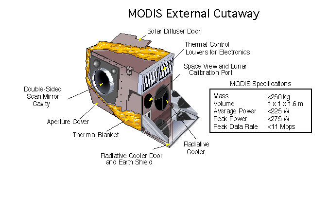
The Moderate Resolution Imaging Spectroradiometer (MODIS) is a satellite-based sensor used for earth and climate measurements. There are two MODIS sensors in Geocentric orbit, Earth orbit: one on board the Terra (satellite), Terra (Earth Observing System, EOS AM) satellite, launched by NASA in 1999; and one on board the Aqua (satellite), Aqua (EOS PM) satellite, launched in 2002. Since 2011, MODIS operations have been supplemented by VIIRS sensors, such as the one aboard Suomi NPP. The systems often conduct similar operations due to their similar designs and orbits (with VIIRS data systems deisgned to be compatible with MODIS), though they have subtle differences contributing to similar but not identical uses. The MODIS instruments were built by Santa Barbara Remote Sensing. They capture data in 36 spectral bands ranging in wavelength from 0.4 μm to 14.4 μm and at varying spatial resolutions (2 bands at 250 m, 5 bands at 500 m and 29 bands at 1 km). Together th ... [...More Info...] [...Related Items...] OR: [Wikipedia] [Google] [Baidu] |
Sapelo Island
Sapelo Island is a state-protected barrier island located in McIntosh County, Georgia. The island is accessible only by boat; the primary ferry comes from the Sapelo Island Visitors Center in McIntosh County, Georgia, a seven-mile (11 km), twenty-minute trip. It is the site of Hog Hammock, the last known Gullah community. Access to the island is restricted to residents, landowners, or guests thereof. Public access must be obtained by getting a permit issued by state tourism authorities. Approximately 97 percent of the island is owned by the state of Georgia and is managed by the Georgia Department of Natural Resources; the remainder is under private ownership. The western perimeter of Sapelo is the Sapelo Island National Estuarine Research Reserve (SINERR) which is part of NOAA's National Estuarine Research Reserve system (NERR). The University of Georgia Marine Institute, which is focused on research and education, is located on on the south end of the island. ... [...More Info...] [...Related Items...] OR: [Wikipedia] [Google] [Baidu] |
University Of Georgia Marine Institute
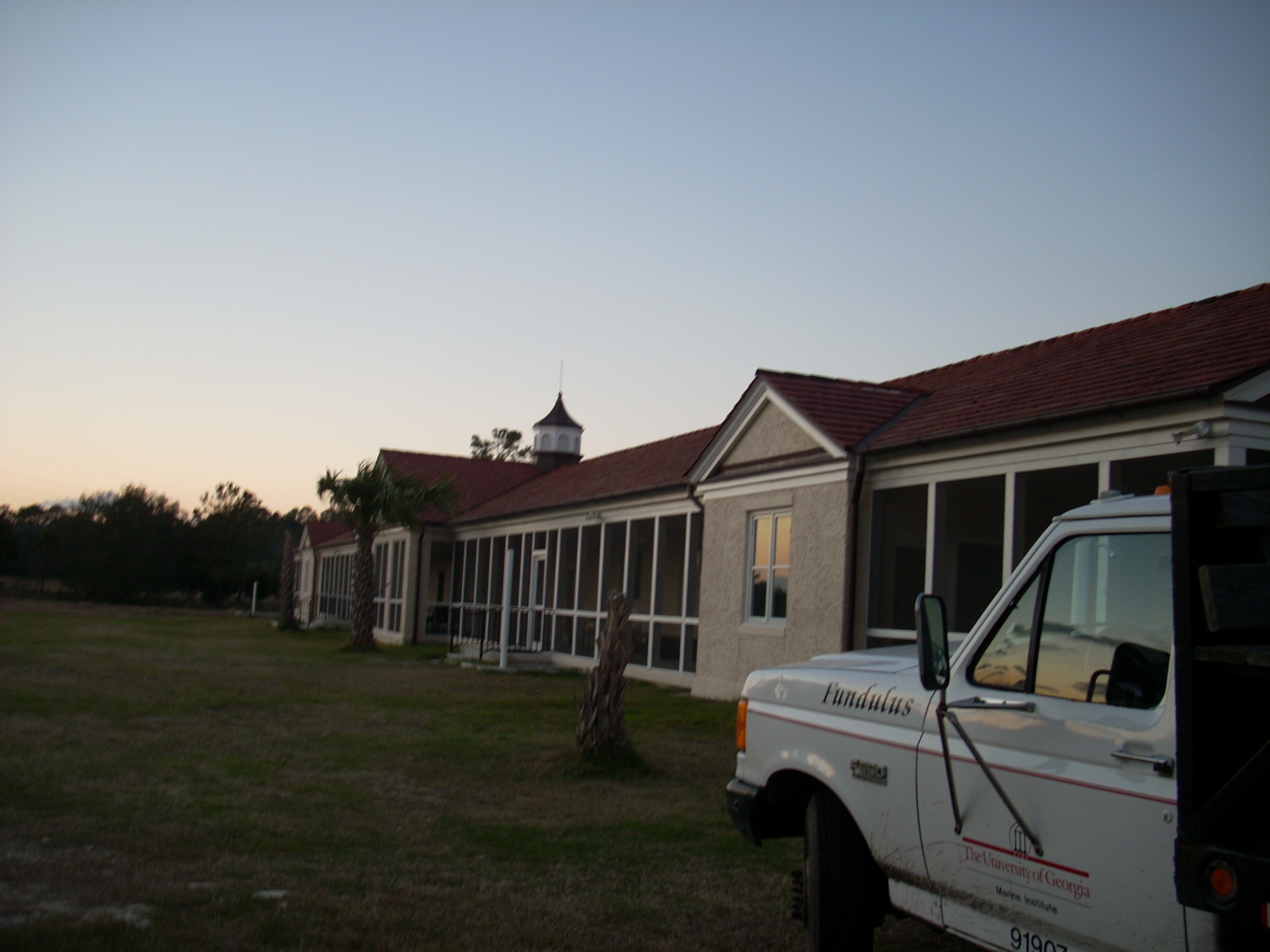
The University of Georgia Marine Institute (UGAMI) is a nearshore ecological and geological research station located on Sapelo Island off the coast of Georgia (U.S. state), Georgia in the United States. This island lies between the Atlantic Ocean and a pristine salt marsh. A ferry takes passengers from Meridian, Georgia, Meridian (between Darien, Georgia, Darien and Crescent, Georgia, Crescent) to Sapelo Island. The Island has fewer than 100 full-time residents. The Institute was created in 1953 and is currently a unit of the University of Georgia's Office of Research. The Institute is 280 miles southeast of the University of Georgia's main campus in Athens, Georgia, Athens. UGAMI is world-renowned for its research on coastal marine and estuarine ecosystems. Education UGAMI offers life-changing experiences for undergraduate and graduate students. Approximately 600-700 university students train there each year. Students experience complete immersion in field-based academic stu ... [...More Info...] [...Related Items...] OR: [Wikipedia] [Google] [Baidu] |
Nanoracks CubeSat Deployer
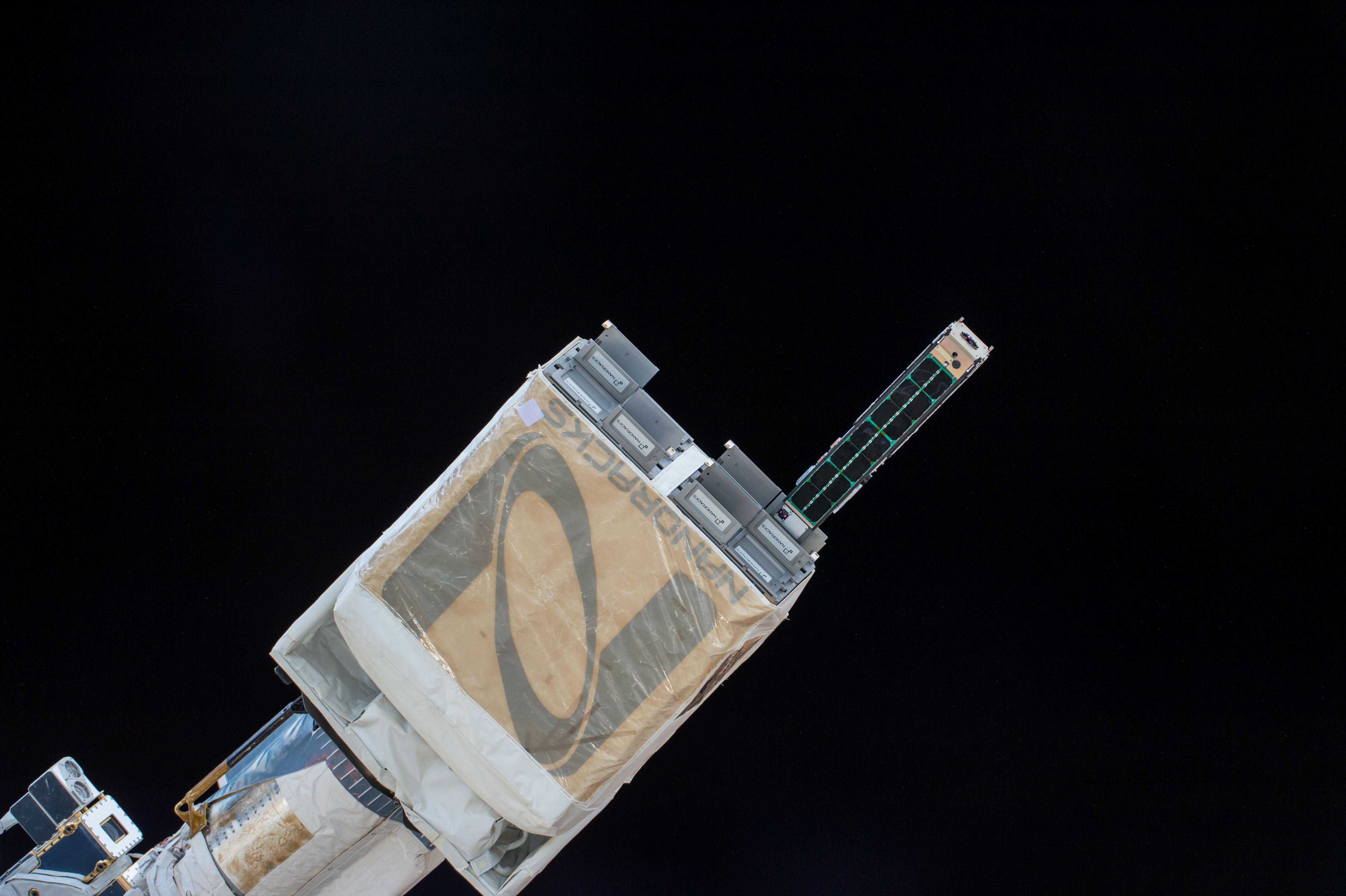
The Nanoracks CubeSat Deployer (NRCSD) is a device to deploy CubeSats into orbit from the International Space Station (ISS). In 2014, two CubeSat deployers were on board the International Space Station (ISS): the Japanese Experiment Module (JEM) Small Satellite Orbital Deployer (J-SSOD) and the Nanoracks CubeSat Deployer (NRCSD). The J-SSOD is the first of its kind to deploy small satellites from the International Space Station (ISS). The NRCSD is the first commercially operated small satellite deployer from the ISS, maximizing full capabilities of each airlock cycle of deployments. CubeSats belong to a class of research spacecraft called nanosatellites. The basic cube-shaped satellites measure on each side, weigh less than , and have a volume of about , although there are CubeSats which are built and deployed with sizes of multiples of 10 cm in length. , one method of getting CubeSats to orbit is to transport them aboard a larger spacecraft as part of a cargo load to ... [...More Info...] [...Related Items...] OR: [Wikipedia] [Google] [Baidu] |


