|
Sindhuli
Sindhuli District ( ne, सिन्धुली जिल्ला), a part of the Bagmati Province, is one of the seventy-seven districts of Nepal, a landlocked country of South Asia. The district, with Sindhulimadhi Kamalamai as its district headquarters and covers an area of . In 2001, it had a population of 279,821, in 2011 the population was 296,192.Household and population by districts, Central Bureau of Statistics (CBS) Nepal 
Etymology i) Before being annexed as an integral part of Nepal, it was under the governance ...[...More Info...] [...Related Items...] OR: [Wikipedia] [Google] [Baidu] |
Kamalamai Temple
Kamalamai (former name: Sindhulimadi; ne, सिन्धुलीमाडी) is a municipality in Sindhuli District, in the Bagmati Province of central south Nepal. At the time of the 2011 Nepal census it had a population of 39,413 people in 9,304 households. The city is located in the Sindhuli Valley of central south Nepal. The historic symbol of the valley, Sindhuli Gadhi fort, is at the peak of a hill of the Mahabharata range. The city is in the plain valley made by the Kamla River. Kamalamai Municipality is the largest municipality of Nepal according to area. History The occupation of the Kuti Pass in about 1756 stopped the valley's trade with Tibet. Finally, King Prithvi Narayan Shah entered the valley after the victory of Kirtipur. King Jaya Prakash Malla of Kathmandu sought help from the British and so the East India Company sent a contingent of soldiers under Captain Kinloch in 1767. The British force was defeated at Sindhuli by Prithvi Narayan Shah's army. It was the ... [...More Info...] [...Related Items...] OR: [Wikipedia] [Google] [Baidu] |
Kamalamai
Kamalamai (former name: Sindhulimadi; ne, सिन्धुलीमाडी) is a municipality in Sindhuli District, in the Bagmati Province of central south Nepal. At the time of the 2011 Nepal census Nepal conducted a widespread national census in 2011 by the Nepal Central Bureau of Statistics. Working with the 58 municipalities and the 3915 Village Development Committees at a district level, they recorded data from all the municipalities an ... it had a population of 39,413 people in 9,304 households. The city is located in the Sindhuli Valley of central south Nepal. The historic symbol of the valley, Sindhuli Gadhi fort, is at the peak of a hill of the Mahabharata range. The city is in the plain valley made by the Kamla River. Kamalamai Municipality is the largest municipality of Nepal according to area. History The occupation of the Kuti Pass in about 1756 stopped the valley's trade with Tibet. Finally, King Prithvi Narayan Shah entered the valley after the vict ... [...More Info...] [...Related Items...] OR: [Wikipedia] [Google] [Baidu] |
Bagmati Province
Bagmati Province ( ne, बाग्मती प्रदेश, ''Bagmati Pradesh'') is one of the seven provinces of Nepal established by the constitution of Nepal. The province is Nepal's second-most populous province and fifth largest province by area. Bagmati is bordered by Tibet Autonomous Region of China to the north, Gandaki Province to the west, Province No. 1 to the east, Madhesh Province and the Indian state of Bihar to the south. With Hetauda as its provincial headquarters, the province is also the home to the country's capital Kathmandu, is mostly hilly and mountainous, and hosts mountain peaks including Gaurishankar, Langtang, Jugal, and Ganesh. Being the most populous province of Nepal, it possesses rich cultural diversity with resident communities and castes including Newar, Tamang, Madhesis, Sherpa, Tharu, Chepang, Jirel, Brahmin, Chhetri , Marwari and more. It hosted the highest number of voters in the last election for the House of Representatives ... [...More Info...] [...Related Items...] OR: [Wikipedia] [Google] [Baidu] |
Roads In Nepal
The Economic Survey 2014–15 released by the Ministry of Finance (Nepal), shows that the country has total road network of 80,078 km that includes 26,935 km roads constructed and being maintained by the Department of Roads (DoR) and 53,143 km roads constructed by the government local bodies. This includes the national highway system, feeder roads, district roads and urban roads. National Highways This is the list of national highways in Nepal. Feeder Roads This is the list of feeder or regional roads in Nepal. District Roads Road that improve the commutes and connectivity within a district are considered District Roads. Below is data from Department of Roads, Nepal.https://dor.gov.np/home/publication/statistics-of-strategic-road-network-2-17-18/force/part-2-ssrn-2-17-18 See also *National Highway System (Nepal) *Churia Tunnel External links * * * {{cite web , url = https://dor.gov.np/home/publication/general-documents/nepal-road-standard-2-7 , ... [...More Info...] [...Related Items...] OR: [Wikipedia] [Google] [Baidu] |
District Coordination Committee
District administration makes up the third level of government division in Nepal. The provision for a District Assembly, which acts as the legislature at the district-level, is mentioned in Part 17 of the Constitution of Nepal. The 77 districts of Nepal each have their own district assemblies which in turn elect their own District Coordination Committees, which serves as the executive at the district-level. In addition to this each district also has a District Administration Office which oversees the general administration of each district. District Administration Office The District Administration Office ( ne, जिल्ला प्रशासन कार्यालय) is a general administration of government in each district of Nepal. The government of Nepal appoints a Chief District Officer in each district to function as a Chief Administration Officer. The Local Administration Act, 2028 (1971) was implemented to conduct local administration in accordance with the dece ... [...More Info...] [...Related Items...] OR: [Wikipedia] [Google] [Baidu] |
Tamang Language
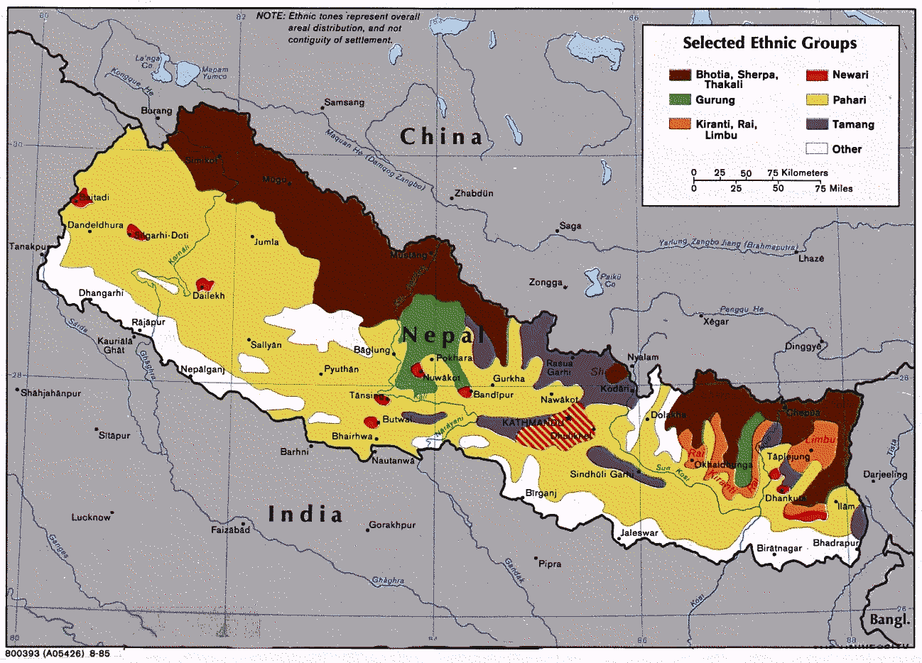
Tamang (Devanagari: तामाङ; ''tāmāng'') is a term used to collectively refer to a dialect cluster spoken mainly in Nepal, Sikkim, West Bengal ( Darjeeling) and North-Eastern India. It comprises Eastern Tamang, Northwestern Tamang, Southwestern Tamang, Eastern Gorkha Tamang, and Western Tamang. Lexical similarity between Eastern Tamang (which is regarded as the most prominent) and other Tamang languages varies between 81% to 63%. For comparison, lexical similarity between Spanish and Portuguese, is estimated at 89%. Ethnologue report for Spanish Dialects '' Ethnologue'' divides Tamang into the following varieties due to mutual unintelligibility. *Eastern Tamang: 759,000 in Nepal (2000 WCD). Population total all countries: 773,000. Sub-dialects are as follows. **Outer-Eastern Tamang (Sailung Tamang) **Central-Eastern Tamang (Temal Tamang) **Southwestern Tamang (Kath-Bhotiya, Lama Bhote, Murmi, Rongba, Sain, Tamang Gyoi, Tamang Gyot, Tamang Lengmo, Tamang Tam) *We ... [...More Info...] [...Related Items...] OR: [Wikipedia] [Google] [Baidu] |
Magar Language
Magar Dhut ( ne, मगर ढुट, ) is a Sino-Tibetan Language spoken mainly in Nepal, Southern Bhutan, and in Darjeeling and Sikkim, India, by the Magar people. It is divided into two groups (Eastern and Western) and further dialect divisions give distinct tribal identity. In Nepal 788,530 people speak the language. While the government of Nepal developed Magar language curricula, as provisioned by the constitution, the teaching materials have never successfully reached Magar schools, where most school instruction is in the Nepali language. It is not unusual for groups with their own language to feel that the "mother-tongue" is an essential part of identity. The Dhut Magar language is sometimes lumped with the Magar Kham language spoken further west in Bheri, Dhaulagiri, and Rapti zones. Although the two languages share many common words, they have major structural differences and are not mutually intelligible. Geographical distribution Western Magar Western Maga ... [...More Info...] [...Related Items...] OR: [Wikipedia] [Google] [Baidu] |
Districts Of Nepal
Districts in Nepal are second level of administrative divisions after provinces. Districts are subdivided in municipalities and rural municipalities. There are seven provinces and 77 districts in Nepal. After the state's reconstruction of administrative divisions, Nawalparasi District and Rukum District were divided into Parasi District (officially Nawalparasi (West of Bardaghat Susta) District) and Nawalpur District (officially Nawalparasi (East of Bardaghat Susta) District), and Eastern Rukum District and Western Rukum District respectively. District official include: * Chief District Officer, an official under Ministry of Home Affairs is appointed by the government as the highest administrative officer in a district. The C.D.O is responsible for proper inspection of all the departments in a district such as health, education, security and all other government offices. * District Coordination Committee acts as an executive to the District Assembly. The DCC coordin ... [...More Info...] [...Related Items...] OR: [Wikipedia] [Google] [Baidu] |
Provincial Assembly (Nepal)
The Provincial Assembly ( ne, प्रदेश सभा; ''Pradesh Sabha'') is the unicameral legislative assembly for a federal province of Nepal. According to Article 176 of the Constitution of Nepal 2015, following the dissolution of the provincial assembly all the members forming the Provincial Assembly are elected. The term for the Provincial Assembly is five years, except when dissolved earlier. Candidates for each constituency are chosen by the political parties or stand as independents. Each constituency elects one member under the first past the post system of election. Since Nepal uses a parallel voting system, voters cast another ballot to elect members through the party-list proportional representation. The current constitution specifies that sixty percent of the members should be elected from the first past the post system and forty percent through the party-list proportional representation system. Women should account for one third of total members electe ... [...More Info...] [...Related Items...] OR: [Wikipedia] [Google] [Baidu] |
2011 Nepal Census
Nepal conducted a widespread national census in 2011 by the Nepal Central Bureau of Statistics. Working with the 58 municipalities and the 3915 Village Development Committees at a district level, they recorded data from all the municipalities and villages of each district. The data included statistics on population size, households, sex and age distribution, place of birth, residence characteristics, literacy, marital status, religion, language spoken, caste/ethnic group, economically active population, education, number of children, employment status, and occupation. *Total population in 2011: 26,494,504 *Increase since last census 2001: 3,343,081 *Annual population growth rate (exponental growth): 1.35 *Number of households ... [...More Info...] [...Related Items...] OR: [Wikipedia] [Google] [Baidu] |
Maithili Language
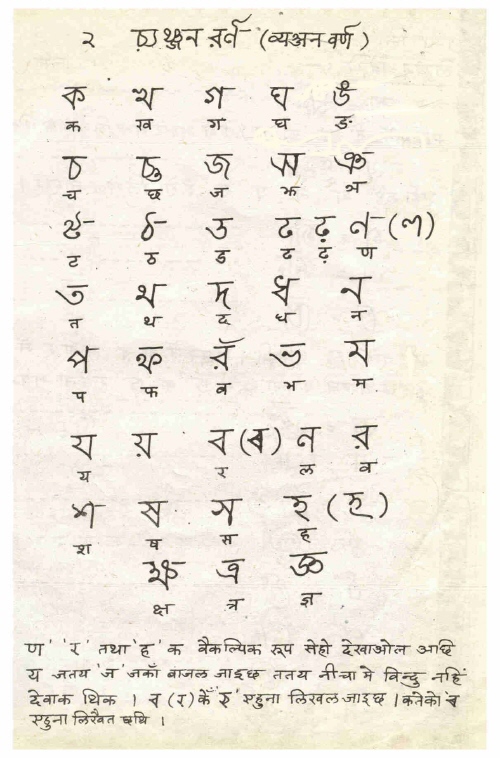
Maithili () is an Indo-Aryan language spoken in parts of Languages of India, India and Languages of Nepal, Nepal. It is native to the Mithila region, which encompasses parts of the Indian states of Bihar and Jharkhand as well as Nepal's eastern Terai. It is one of the 22 Eighth Schedule to the Constitution of India, officially recognised languages of India and the second most spoken Languages of Nepal, Nepalese language in Nepal. The language is predominantly written in Devanagari, but there were two other historically important scripts: Tirhuta script, Tirhuta, which has retained some use until the present, and Kaithi script, Kaithi. Official status In 2003, Maithili was included in the 8th Schedule, Eighth Schedule of the Indian Constitution as a recognised language of India, Indian language, which allows it to be used in education, government, and other official contexts in India. Maithili language is included as an optional paper in the Union Public Service Commission, UP ... [...More Info...] [...Related Items...] OR: [Wikipedia] [Google] [Baidu] |


