|
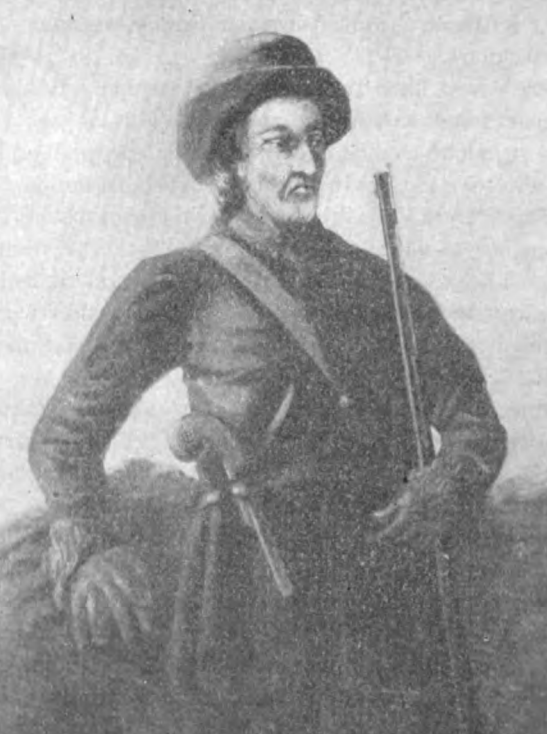
Simon Girty
Simon Girty (14 November 1741 – 18 February 1818) was an interpreter with the British Indian Department during the American Revolutionary War and Northwest Indian War. As a child he and his brothers James and George were captured and adopted by Native Americans. Freed after living with the Seneca people, Seneca for seven years, Girty worked as a trader and interpreter. During the American Revolution he became disillusioned with the Patriot (American Revolution), Patriot cause, and in 1778, fled to Fort Detroit where he was hired as an interpreter for the British Indian Department. Girty accompanied Britain's Indigenous allies during the 1780 Bird's invasion of Kentucky, expedition against Kentucky, Kentucky's frontier settlements and was present at Lochry's Defeat in 1781. Girty was held complicit when the Lenape tortured William Crawford (soldier), Colonel William Crawford to death following the Battle of Sandusky. He continued to serve with the British Indian Department for ma ... [...More Info...] [...Related Items...] OR: [Wikipedia] [Google] [Baidu] |
Amherstburg
Amherstburg is a town near the mouth of the Detroit River in Essex County, Ontario, Canada. In 1796, Fort Malden was established here, stimulating growth in the settlement. The fort has been designated as a National Historic Site. The town is approximately south of the U.S. city of Detroit, Michigan, facing Wyandotte, Grosse Ile Township, Brownstown Charter Township, Trenton, and Gibraltar, Michigan. It is part of the Windsor census metropolitan area. Communities Besides the town proper of Amherstburg, the town of Amherstburg comprises a number of villages and hamlets, including the following communities: * Former Anderdon Township: – Edgewater Beach, McGregor (partially), River Canard (partially); ''Golfview'', ''Kingsbridge'', ''Pointe West''; ''Auld'', ''Delisle's Corners'' (partially), ''Loiselleville'', ''Paquette Corners'' (partially), ''Rivière-Aux-Canards'', ''Southwick'', ''Splitlog'' * Former Malden Township: – ''Amherstburg'', Amherst Point, ... [...More Info...] [...Related Items...] OR: [Wikipedia] [Google] [Baidu] |
Squirrel Hill
Squirrel Hill is a residential neighborhood in the East End of Pittsburgh, Pennsylvania, United States. The city officially divides it into two neighborhoods, Squirrel Hill North and Squirrel Hill South, but it is almost universally treated as a single neighborhood. Geography Squirrel Hill is located at and has two ZIP codes: 15217 and 15232. Surrounding neighborhoods Squirrel Hill North has five borders with the Pittsburgh neighborhoods of Shadyside to the north, Point Breeze to the east, Squirrel Hill South to the south, Central Oakland to the southwest and North Oakland to the west. Squirrel Hill South has nine land borders with the Pittsburgh neighborhoods of Squirrel Hill North to the north and northwest, Point Breeze to the northeast, Regent Square to the east, Swisshelm Park to the southeast, Glen Hazel and Hazelwood to the south-southwest, Greenfield to the southwest, and South Oakland and Central Oakland to the west. Across the Monongahela River to ... [...More Info...] [...Related Items...] OR: [Wikipedia] [Google] [Baidu] |
Treaty Of Easton
The Treaty of Easton was a colonial agreement in North America signed in October 1758 during the French and Indian War (Seven Years' War) between British colonials and the chiefs of 13 Native American nations, representing tribes of the Iroquois, Lenape (Delaware), and Shawnee. Negotiations over more than a week were concluded on October 26, 1758, at a ceremony held in Easton, Pennsylvania between the British colonial governors of the provinces of Pennsylvania and New Jersey, and representatives of 13 Indian nations, including the Iroquois, who sent chiefs of three of their nations to ensure their continued domination of their Ohio Country region; the eastern and western Lenape (Delaware), represented by two chiefs and headmen; Shawnee and others. More than 500 Native Americans attended the outdoor ceremony, after lengthy negotiations to bring peace to the regions of Pennsylvania, New Jersey and the Ohio Country. Conrad Weiser served as an interpreter and arbitrator for the Brit ... [...More Info...] [...Related Items...] OR: [Wikipedia] [Google] [Baidu] |
Guyasuta
Guyasuta (c. 1725–c. 1794; , "he stands up to the cross" or "he sets up the cross") was an important Native American leader of the Seneca (tribe), Seneca people in the second half of the eighteenth century, playing a central role in the diplomacy and warfare of that era. Although he became friends with George Washington in 1753, he sided with the French against Britain during the French and Indian War and fought against the British in Pontiac's War. He later supported the British during the American Revolutionary War. In his final years, he engaged in peacemaking to end the Northwest Indian War. Early life and family Born in a Mingo community in upstate New York, probably on the Genesee River, he and his family migrated along the Allegheny River and after 1725 they settled in Logstown, a mostly-Iroquois village in Pennsylvania. Guyasuta was a maternal uncle to Cornplanter and Handsome Lake. He was distantly related to Governor Blacksnake and Red Jacket. Guyasuta married ... [...More Info...] [...Related Items...] OR: [Wikipedia] [Google] [Baidu] |
Kittanning Expedition
The Kittanning Expedition, also known as the Armstrong Expedition or the Battle of Kittanning, was a raid during the French and Indian War that led to the destruction of the American Indian village of Kittanning, which had served as a staging point for attacks by Lenape warriors against colonists in the British Province of Pennsylvania. Commanded by Lieutenant Colonel John Armstrong Sr., this raid deep into hostile territory was the only major expedition carried out by Pennsylvanian provincial troops during a brutal backcountry war. Early on September 8, 1756, they launched a surprise attack on the Indian village. Background Although it eventually became a worldwide conflict known as the Seven Years' War, the French and Indian War began on the Pennsylvania frontier as a struggle for control of the Ohio Country. With the surrender of George Washington at Fort Necessity in 1754 and Braddock's defeat in 1755, the settlers on the Pennsylvania frontier were without professiona ... [...More Info...] [...Related Items...] OR: [Wikipedia] [Google] [Baidu] |
Kittanning (village)
Kittanning (Lenape language, Lenape Kithanink; ) was an 18th-century Native Americans in the United States, Native American village in the Ohio Country, located on the Allegheny River at present-day Kittanning, Pennsylvania. The village was at the western terminus of the Kittanning Path, an Indian trail that provided a route across the Alleghenies between the Ohio River, Ohio and Susquehanna River, Susquehanna river basins. Together with Logstown, Pickawillany, Upper Sandusky, Ohio, Sandusky, and Lower Shawneetown, Kittanning was one of several large multiethnic and autonomous "Indian republics" made up of a variety of smaller disparate social groups: village fragments, extended families, or individuals, often survivors of epidemics and refugees from conflicts with other Native Americans or with Europeans. [...More Info...] [...Related Items...] OR: [Wikipedia] [Google] [Baidu] |
Louis Coulon De Villiers
Louis Coulon, Sieur de Villiers (17 August 1710 – 2 November 1757) was a French military officer who served during the French and Indian War. Perhaps his greatest claim to fame is the fact that he is the only military opponent to force George Washington to surrender. Coulon was born into a prominent French Canadian family. His grandfather, Sieur Raoul-Guillaume Coulon, was an officer in the French Royal Army. Life He was the son of Nicolas Antoine Coulon de Villiers and Elizabeth Le Couturier. Louis Coulon de Villiers entered the military in 1733. He had risen to the rank of captain by the outbreak of the French and Indian War and was assigned to Fort Duquesne. His half-brother, Ensign Joseph Coulon de Jumonville, was killed at the Battle of Jumonville Glen after having surrendered to George Washington. Coulon sought revenge and led an expedition to attack the British garrison at Fort Necessity under Washington's command. On the morning of July 3, 1754, Coulon's troops ... [...More Info...] [...Related Items...] OR: [Wikipedia] [Google] [Baidu] |
Fort Granville
Fort Granville was a militia stockade located in the colonial Province of Pennsylvania. Its site was about a mile from Lewistown, in what is now Granville Township, Mifflin County. Active from 1755 until 1756, the stockade briefly sheltered pioneer settlers in the Juniata River valley during the French and Indian War. The fort was attacked on August 2, 1756, by a mixed force of French troops and Native Americans, mostly Lenape warriors. The fort’s garrison surrendered the strongpoint to these attackers, who celebrated their victory and destroyed the stockade. Background After the French victory in the Battle of the Monongahela on 9 July 1755, English settlers, who set up farms on Native American lands that they had illegally squatted on drew in hostilities from Native Americans. Native Americans who never legally ceded their land, resorted to hit-and-run tactics on the Pennsylvania frontier. The Native American tribes whose land was underhandedly sold by the Iroquois an ... [...More Info...] [...Related Items...] OR: [Wikipedia] [Google] [Baidu] |
French And Indian War
The French and Indian War, 1754 to 1763, was a colonial conflict in North America between Kingdom of Great Britain, Great Britain and Kingdom of France, France, along with their respective Native Americans in the United States, Native American allies. European historians generally consider it a related conflict of the wider 1756 to 1763 Seven Years' War, although in the United States it is viewed as a singular conflict unassociated with any European war. Although Britain and France were officially at peace following the Treaty of Aix-la-Chapelle (1748), tensions over trade continued in North America. These culminated in a dispute over the Forks of the Ohio, and the related French Fort Duquesne which controlled them. In May 1754, this led to the Battle of Jumonville Glen, when Colony of Virginia, Virginia militia led by George Washington ambushed a French patrol. In 1755, Edward Braddock, the new Commander-in-Chief, North America, planned a four-way attack on the French. None s ... [...More Info...] [...Related Items...] OR: [Wikipedia] [Google] [Baidu] |
Shermans Creek (Pennsylvania)
Shermans Creek is a U.S. Geological Survey. National Hydrography Dataset high-resolution flowline dataThe National Map accessed August 8, 2011 tributary of the Susquehanna River in Perry County, Pennsylvania. Shermans Creek joins the Susquehanna River just downstream of Duncannon. As of April 2010, the United States Geological Survey Geographic Names Information System made the decision to modify the name to be "Shermans Creek", prior to that date the creek was referred to as "Sherman Creek" by the United States Geological Survey. In some cases it can be found referred to as "Sherman's Creek" with an apostrophe although most locals refer to it as Shermans Creek. Shermans Creek is purported to be named after a Native American fur trader who lived near and drowned crossing the creek on horseback. Bridges * Book's Covered Bridge * Dellville Covered Bridge See also *List of rivers of Pennsylvania This is a list of streams and rivers in the U.S. state of Pennsylvania. By ... [...More Info...] [...Related Items...] OR: [Wikipedia] [Google] [Baidu] |
Susquehanna River
The Susquehanna River ( ; Unami language, Lenape: ) is a major river located in the Mid-Atlantic (United States), Mid-Atlantic region of the United States, crossing three lower Northeastern United States, Northeast states (New York, Pennsylvania and Maryland). At long, it is the longest river on the East Coast of the United States. By Drainage basin, watershed area, it is the 16th-largest river in the United States,Susquehanna River Trail Pennsylvania Fish and Boat Commission, accessed March 25, 2010.Susquehanna River , Green Works Radio, accessed March 25, 2010. and also the longest river in the early 21st-century continental United State ... [...More Info...] [...Related Items...] OR: [Wikipedia] [Google] [Baidu] |


